The cosmology of Inca huacas
86
0
0
Full text
(2) 155. Part IV: Field Research. I collected field data during five separate research trips that took place in October 2006, June 2007, October 2007, June 2008, and October 2008. My field assistant, Carlos Aranibar, at my direction took additional photos on other key dates. Certain background information is provided, but astronomical orientations are listed regardless of whether or not they were also supported by historical references. Most of the orientations of this research are sightlines to the horizon that do not involve alignments with walls. This study searched for intentional orientations, but it is possible that a few could be coincidental. Without conclusive evidence for elimination, all that were found to exist are included. I performed research at 29 sites and have divided them into three regions. Chapter 9 covers sites of the region surrounding Cusco, Chapter 10 sites of the Sacred Valley Region, and Chapter 11 those of the Machu Picchu Region. The Region Surrounding Cusco includes 19 sites south of Tambomachay, including Tipon to the east and Saihuite to the west. The Sacred Valley Region is north of Tambomachay and includes seven sites from Pisac to Ollantaytambo. The Machu Picchu Region consists of three sanctuaries in the northwest area of my study. Figures IV-1 and IV-2 show the locations of the sites examined. Chapter and section numbers are included with each site for reference. Most of the sites in chapters 9 through 11 include data taken during my field research that is presented in the appropriate sections. In a few locations I did not attempt to duplicate existing research, but still cite information gathered by others in an effort to present additional information regarding the astronomy of the Incas in the associated region..
(3) 156. Figure IV-1: Research Site Locations (modified from Hemming and Ranney, 1982).. Legend:. 9.2 Kenko Grande*. 10.2 Chinchero*. 10.7 Choquequilla*. 9.12 Tambomachay*. 10.3 Pisac*. 10.8 Ollantaytambo*. 9.13 Sacsahuaman*. 10.4 Quespiwanka*. 11.2 Machu Picchu*. 9.19 Tipon*. 10.5 Cerro Pumahuachana. 11.3 River Intihuatana*. 9.20 Saihuite*. 10.6 Cerro Unoraqui. 11.4 Llactapata*. * actual or potential astronomical orientation or sightline present.
(4) 157. Figure IV-2: Local Cusco Research Site Locations (modified from Bauer, 1998).. Legend:. 9.2 Kenko Grande*. 9.9 Solar Horizons*. 9.15 Sapantiana. 9.3 Kenko Chico*. 9.10 Lanlakuyok*. 9.16 Rumiwasi Bajo*. 9.4 Mesa Redonda. 9.11 Puca Pucara*. 9.17 Rumiwasi Alto*. 9.5 Tetecaca. 9.12 Tambomachay*. 9.18 Kusicallanca*. 9.6 Patallacta. 9.13 Sacsahuaman*. 9.19 Tipon*. 9.7 Kusilluchayoc*. 9.14 Mollaguanca*. 9.20 Saihuite*. 9.8 Lacco*. * actual or potential astronomical orientation or sightline present.
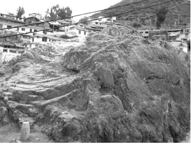
(5) 158. Chapter 9. Region Surrounding Cusco. 9.1 Introduction. Pachacuti instituted a great system of ceques and huacas that emanated in all directions from Cusco’s Coricancha, the primary sun temple of the Incas. He ordered sun temples to be built across the empire so that all could worship the sun (Cobo, 1983 [1653]: 134). Structures in Cusco such as the Coricancha, the Sunturhuasi, and the ushnu of the Hanan Huacaypata plaza figured prominently in Inca astronomy, but are not subjects of my research that involved mainly more rural huacas, especially those that are carved outcroppings. At least 328 huacas were worshipped and cared for, but most did not survive the Catholic purge of idolatries following the Spanish conquest. Those that remain were carved from rock and many of these are examined in this chapter. I have followed the designation system of ceques and huacas that was first mentioned by Cobo (1990 [1653]: 51-84) and later put forth by Bauer (1998). Certain huaca descriptions by Cobo are included in this chapter. A major part of the field data presented is a photographic survey of the astronomical orientations found in many of the carved rock huacas, stones and structures of the area surrounding Cusco. Also included are negative findings for certain huacas and carved rocks that exhibited no signs of celestial orientation. This field research does not involve buildings within Cusco and does not attempt to duplicate the work of others regarding such structures. Certain celestial orientations among buildings of the city, such as the Sunturhuasi, previously have been shown to vertically measure the zenith sun (Zuidema, 1981b). I found huacas in the surrounding countryside to tend more toward horizontal observations. The contrast between city and countryside may indicate why this research found so many orientations to be solstitial rather than for the zenith or anti-zenith sun. Vertical zenith observations could have easily been made among certain structures of Cusco, thus leaving horizontal solar observations for outlying huacas with relatively clear horizons. Figure IV-1 is a location map of the sites of my field research presented in this chapter..
(6) 159 9.2 Kenko Grande. Kenko Grande is located at S13°-30.53’; W071°-58.24’ and 3614 masl.. Motifs and Features: Kenko Grande is a carved rock and was found to exhibit light and shadow effects, solstitial orientations, east-west orientations, stairs, seats, niches, a water source, basins, a cave, a light-tube, altars, a monolith, animal replica stones, and a zigzag channel.. Visible from the Coricancha, Kenko Grande (Figure 9-1) is a sculpted limestone outcrop north of Cusco that incorporates carvings and crevices as well as a stone monolith surrounded by a series of niches along an arced plaza. My field research examined several of Kenko Grande’s rock features for potential astronomical orientations.. Figure 9-1: Kenko Grande and its monolith..
(7) 160. 9.2.1 “The Awakening of the Puma”. Kenko Grande exhibits a visually dramatic phenomenon at the time of the June solstice which is known locally as “the awakening of the puma.” The Inca venerated the condor, puma and snake with regard to cosmological correlations with the sky, earth, and underworld (Van de Guchte, 1990). Located atop the huaca and carved into the stone are two carved cylinders designed for effects of light and shadow (Figure 9-2). The cylinders are about 25 cm high and are spaced 35 cm apart. In close proximity is a small wall with a fissure (Figure 9-3) aligned for the sunrise at the June solstice. Light from the morning sun passes through the fissure and first touches the left side of the left cylinder. As the sun continues to rise its rays move across the cylinder and then illuminate the opposite one as well. The cylinders are situated in such a way that the glowing pair and the relative shadows now resemble a puma – “the puma’s awakening” (Figure 9-4).. Figure 9-2: Cylinders carved on top of Kenko Grande..
(8) 161. Figure 9-3: Fissure aligned for the June solstice sunrise..
(9) 162. Figure 9-4: “The Eyes of the Puma” at June solstice sunrise.. Figure 9-5: Plan of the cylinders and fissure. The line of the fissure (fisura) in the drawing is 62° from north (from Arévalo, 2007)..
(10) 163. Light falling on the cylinders also helps mark the equinoxes and the December solstice. The photo in Figure 9-6 was taken on 20 March 2008. On the day of an equinox the sun rises between the cylinders on the eastern horizon. Its rays soon cast an effect of light and shadow that splits the carving into dark and light halves thought to represent the equal periods of day and night.. Figure 9-6: According to local folklore light and shadow effects at equinox represent the division of day and night.. The December solstice sun rises over the 6372 meter snowpeak Nevado Ausangate on an orientation that crosses between and is tangent to both cylinders..
(11) 164 9.2.2 Zigzag channel. The top of Kenko Grande exhibits many once-fine carvings including an offertory/divination channel flowing to a cave (Figure 9-7). A common motif of carved huacas is a straight or zigzag channel through which liquids, most probably chicha, could flow. The current of energy necessary to establish harmony and maintain equilibrium in the world was stimulated by the pouring of liquid offerings into these channels. The channel begins with a cup-like basin, extending first for 130 cm and then 145 cm before splitting into two 80 cm branches. Kenko in Quechua means a zigzag (Paternosto, 1996).. Figure 9-7: The zigzag channel carved on top of Kenko Grande.. 9.2.3 Interior cave and altars. Located within Kenko Grande is a sculpturally-enhanced cave with two entrances, two altars, niches, and a set of three ritual stairs (Figure 9-8). Locals maintain that light entering the cave within the niche shown at the rear of this photo was reflected by the Incas with gold or silver.
(12) 165 plates in order to illuminate the entire chamber. The cave is oriented along a southeast-northwest axis and includes an additional niche to the right of the altar large enough to hold a mummy.. Figure 9-8: Kenko Grande’s primary altar.. The primary altar was carved and polished with three ritual stairs at its northwestern end (the far side in Figure 9-8). During the time nearing the June solstice sunlight enters the cave, approaches the altar and climbs the three stairs (Figure 9-9). Ritual stairways are common features, symbolizing shamanic movement between the three worlds. Such a cave could serve as a portal for communication with Ucu Pacha, the world below. Light enters through an opening approximately 341.5° in azimuth and an inclination of +40°..
(13) 166. Figure 9-9: Symbolic stairs illuminated by the midday sun in June..
(14) 167 At times of the solar equinoxes the cave’s secondary altar is illuminated at sunrise, a shown in a photo take on 20 March 2008 (Figure 9-10). The opposite entrance of the cave near the main altar is oriented to the equinox sunset. The meaning of this remains uncertain as ethnohistorical evidence has not been found to support Inca interest in equinox horizon observations.. Calculated azimuth of equinox sunrise from the center of the cave opening Measured azimuth from the center of the cave opening to the horizon Measured Azimuth:. 094.0°. Magnetic Declination:. 3.9° W. True Azimuth:. 090.1°. Calculated ESR Azimuth:. 089.9°. ∆ True Az & Calc ESR Az:. 0.2°. Measured Inclination:. +2.0°. Figure 9-10: The secondary altar within Kenko Grande’s cave at equinox sunrise..
(15) 168 9.2.4 Monolith. Kenko Grande’s 5.5 meter high monolith (Figure 9-11) is located near the focal point of a semi-circular shaped plaza that includes a partially destroyed wall containing 19 body-sized niches, plus a 20th opening for an entranceway. Modern interpretations describe this as a puma, a phallic symbol or an axis mundi; the monolith may also have functioned as a gnomon.. Figure 9-11: The monolith at Kenko Grande..
(16) 169 9.3 Kenko Chico. Kenko Chico is located at S13°-30.62’; W071°-58.32’ and 3598 masl.. Motifs and Features: Kenko Chico is a carved rock and was found to exhibit a potential solstitial orientation, stairs, seats, a water source, basins, and a gnomon.. Kenko Chico (Figure 9-12) is located near Kenko Grande to its southwest, separated by a ravine and a small stream. Kenko Chico contains a stone stairway leading to its summit, terraces, and large stone blocks similar in size to many of those used at Sacsahuaman. It is surrounded by a moat and exhibits many carvings, such as steps and seats, in its limestone. Kenko Chico is oriented generally east-west and, while not a structural alignment, Nevado Ausangate can be viewed on the horizon in the direction of the December solstice sunrise. The central staircase is aligned north and south.. Calculated azimuth of December solstice sunrise from the southeast end of Kenko Chico Measured azimuth from the southeast end of Kenko Chico to Nevado Ausangate Measured Azimuth:. 116.0°. Magnetic Declination:. 3.9° W. True Azimuth:. 112.1°. Calculated DSSR Azimuth:. 113.6°. ∆ True Az & Calc DSSR Az:. 1.5°. Measured Inclination:. +2.0°.
(17) 170. Figure 9-12: Kenko Chico..
(18) 171 9.4 Mesa Redonda. Mesa Redonda is located at S13°-30.80’; W071°-58.18’ and 3474 masl.. Motifs and Features: Mesa Redonda is a group of carved rocks and was found to exhibit stairs, a water source, and an altar.. In the residential area immediately below Kenko Chico and visible from the Coricancha is a flat rock known as Mesa Redonda (Figure 9-13). Bauer (1998) states that the boulder and adjacent carved rock are likely candidates for Pachatosa (An 2:2).. [An-2:2] the second guaca of this ceque was named Pachatosa; it was a large stone which was next to [Diego] Cayo’s house. The sacrifice was burned on top of it, and they said that the stone ate it (Cobo, 1990 [1653]: 64).. Figure 9-13: Mesa Redonda..
(19) 172 9.5 Tetecaca. Tetecaca is located at S13°-30.90’; W071°-57.93’ and 3492 masl.. Motifs and Features: Tetecaca is a carved rock and was found to exhibit a niche, a water source, a cave, an altar, a carved cylinder, and a channel.. To the east of Mesa Redonda and also visible from the Coricancha is a large carved outcrop known locally as Tetecaca (Figure 9-14). The boulder includes a modern shrine and has a carved cylinder sculpted upon its upper surface. The site has a good view of the valley and surrounding horizons and the top of the rock includes a mini-landscape reminiscent of the one found at Saihuite.. Figure 9-14: Tetecaca..
(20) 173 9.6 Patallacta. Patallacta is located at S13°-30.75’; W071°-58.11’ and 3492 masl.. Motifs and Features: Patallacta is a carved rock and was found to exhibit seats.. Van de Guchte (1990) calls this outcrop Patallacta (Ch 1:2). Cobo describes a house which may have been nearby.. [Ch-1:2] The second guaca of the ceque was called Patallacta. It was a house which Inca Yupanqui designated for his sacrifices, and he died in it. The Incas who succeeded him thereafter made ordinary sacrifice here. In general, all the things which they consumed in sacrifice were offered for the health and prosperity of the Inca (Cobo, 1990 [1653]: 51).. The rock is visible from the Coricancha and has been damaged by the modern road cut below it (Figure 9-15). Carvings, especially those of seats, are extant and from the top of the rock there is a commanding view of the north half of the valley where horizon events could have been observed..
(21) 174. Figure 9-15: Patallacta.. 9.7 Kusilluchayoc. Kusilluchayoc is located at S13°-30.51’; W071°-57.94’ and 3637 masl.. Motifs and Features: Kusilluchayoc is a carved rock with adjacent structures and was found to exhibit a solstitial orientation, niches, a water source, a basin, animal replica stones, and a channel.. Proceeding upslope from Patallacta is another large limestone outcrop, Kusilluchayoc, which is situated about 300 meters south of Lacco. Kusilluchayoc consists of two rocks separated by a central corridor and a series of walls constructed on its western side (Figure 9-16). In Quechua Kusilluchayoc means ‘the one with the monkey’ (Van de Guchte, 1990) and among the carvings on the huaca are those of three monkeys, a serpent and a puma..
(22) 175. Figure 9-16: The western face of Kusilluchayoc.. Several masonry walls form multiple rooms with windows and niches on Kusilluchayoc’s western face. Both a corridor between the rocks and a body-size niche face the setting point of the June solstice sun (Figure 9-17).. Calculated azimuth of June solstice sunset from the center of the corridor Measured azimuth along the corridor to the horizon Measured Azimuth:. 297.5°. Magnetic Declination:. 3.9° W. True Azimuth:. 293.6°. Calculated JSSS Azimuth:. 295.3°. ∆ True Az & Calc JSSS Az:. 1.7°. Measured Inclination:. +4.0°.
(23) 176. Figure 9-17: View from Kusilluchayoc in the direction of the June solstice sunset..
(24) 177 9.8 Lacco. Lacco is located at S13°-30.29’; W071°-57.89’ and 3662 masl.. Motifs and Features: Lacco is a carved rock and was found to exhibit light and shadow effects, a solstitial orientation, a zenith orientation, stairs, seats, niches, a water source, basins, caves, light-tubes, altars, a carved cylinder, animal replica stones, and channels.. Lacco is a carved limestone outcropping incorporating several astronomical orientations (Figure 9-18). It was barely visible from the Coricancha. The elaborate huaca, also known as Salonpuncu, is located above Cusco to the northeast of Kenko Grande. Zuidema (1977) and Aveni (1981a) suggest Lacco as being near the site of Chuquimarca (An 3:4).. [An-3:4] The fourth was called Chuquimarca; it was a temple of the Sun on the hill of Manto calla, in which they said that the Sun descended many times to sleep. For this reason, in addition to everything else, they offered it children (Cobo, 1990 [1653]: 65).. Lacco is the largest limestone outcrop in the vicinity, covering an area of some 1670 square meters, and contains elaborately carved stairways, caves and niches. There are at least seven other carved outcrops located within a 1 km radius. Two stairways face the northwest toward the June solstice sunset. Lacco’s upper surface is extensively carved with examples such as seats, sacred animals and a carved cylinder. A fault runs like a corridor between the northeast and southeast sides of the rock. There are short sections of stairways and a series of niches, like doorways, large enough to stand inside. A canal, originating at Ucu Ucu some 3 kms distant, runs near the base of the rock and the Inca road to Pisac is nearby. Three caves were modified with altars and exhibit astronomical orientations..
(25) 178. Figure 9-18: Lacco with Nevado Ausangate in the distance.. Figure 9-19: Plan of Lacco. (A) is the 065° direction of the June solstice sunrise from the Northeast Cave. The other two caves have vertical alignments (modified from Van de Guchte, 1990)..
(26) 179. 9.8.1 Northeast Cave. Lacco, on its northeast face, has a cave opening which is oriented for the June solstice sunrise (Figure 9-20). The greatest eastward angle as viewed through the cave’s entrance is 078°, therefore at least some sunlight is admitted to a portion of the interior for several days before and after the solar standstill. The sun centers on the cave opening at the time of the June solstice as show in a photo taken on 22 June 2007 (Figure 9-21). During this period sunlight enters the portal, illuminating the altar and cave interior (Figure 9-22). I first noted the solar alignment in October 2006 and returned in June 2007 to document the phenomenon. The process began very quickly at 06:25 and persisted until the last vestiges of light disappeared from the altar’s stone surface nearly two hours later at 08:24. The Northeast Cave is located at S13°-30.34’; W071°57.86’ and 3650 masl.. Calculated azimuth of June solstice sunrise from the center of the cave opening Measured azimuth from the center of the cave opening to the sunrise position on the horizon Measured Azimuth:. 067.5°. Magnetic Declination:. 3.9° W. True Azimuth:. 063.6°. Calculated JSSR Azimuth:. 065.0°. ∆ True Az & Calc JSSR Az:. 1.4°. Measured Inclination:. +3.0°. Immediately to the east of the Northeast Cave is the north opening of the crevasse running across Lacco. It also is oriented approximately to the June solstice sunrise. Two ceremonial thrones are situated in front of and below two large steps leading to the Northeast Cave’s opening. The thrones might have been occupied during the rising of the solstice sun..
(27) 180. Figure 9-20: Lacco’s Northeast Cave and two ceremonial thrones to the right of the huaca’s crevasse..
(28) 181. Figure 9-21: June solstice sunrise as seen from Lacco’s Northeast Cave. The sun advances each day from the right until reaching the central standstill as depicted, after which it reverses course and retreats..
(29) 182. Figure 9-22: Lacco’s Northeast Cave and altar illuminated by the June solstice early morning sun..
(30) 183 9.8.2 Southwest Cave. Lacco’s Southwest Cave contains a small altar below a light-tube oriented to the ecliptic at times when the sun’s path is between 70° and 75° above the horizon. When properly positioned, either the sun or a full moon can illuminate the altar within. A waxing crescent moon was viewed through the light tube on 26 October 2006, near the October 30th date of the zenith sun (Figure 923). The cave’s door is oriented facing 235°. The Southwest Cave is located at S13°-30.35’; W071°-57.89’ and 3662 masl.. A small altar was carved within the cave and is aligned to be illuminated by light passing through the tube. The elevation from the altar to the lower edge of the light tube is approximately 70° at an azimuth of 211°. The cave includes two recesses cut into its western wall.. Figure 9-23: A waxing crescent moon as viewed through the light-tube in Lacco’s Southwest Cave..
(31) 184 9.8.3 Southeast Cave. Lacco’s second cave with light-tube illumination is known both as the Temple of the Moon and the Temple of the Sun. This chamber is the most elaborate found within the huaca and the remains of carvings of both a puma and a snake adorn its entrance (Figure 9-24), the serpent symbolizing passage into the realm of Ucu Pacha (Paternosto, 1996). I found sunlight to be admitted through the cave’s light-tube near solar noon on 26 October 2007. The shaft aligns vertically to admit the light of the zenith sun. This occurrence took place with the sun at an elevation of 89° (Figure 9-25). The high aspect of this opening makes illumination possible from September through March when the sun’s altitude is greatest in the Southern Hemisphere sky. The light-tube is directed at a finely carved altar (Figure 9-26) on an azimuth of 055°, which also can be illuminated by the moon. The Southeast Cave is located at S13°-30.36’; W071°-57.86’ and 3655 masl.. Figure 9-24: A snake is carved into the entrance of Lacco’s Southeast Cave..
(32) 185. Figure 9-25: The sun as viewed through Lacco’s Southeast Cave’s light-tube..
(33) 186. Figure 9-26: Recording data on the illuminated altar..
(34) 187 9.9 Huaca with two circles oriented for solar horizon events. The huaca is located at S13°-30.30’; W071°-58.07’ and 3662 masl.. Motifs and Features: The huaca is a carved rock and was found to exhibit solstitial orientations, east-west orientations, seats and carved cylinders.. Located between Kenko Grande and Lacco (Figure 9-27) is a small huaca exhibiting interesting orientations for the solstices and equinoxes (Figure 9-28). Within it are two flat circular carvings, one large and one small, oriented in such a way that they could have had utility as solar gauges (Figure 9-29). A line drawn across the circular carvings, aligned east-west with respect to one another, would indicate the horizon positions of the equinox sunrises and sunsets. Intersecting lines drawn tangent to the carvings point to the sunrises and sunsets of the June and December solstices (Figure 9-30).. Figure 9-27: Location of the huaca with two circles oriented for solar horizon events (modified from Van de Guchte, 1990)..
(35) 188. Figure 9-28: The huaca with two circles oriented for solar horizon events..
(36) 189. Figure 9-29: Two circles, large and a small, are carved into the huaca’s base..
(37) 190. Figure 9-30: Circle orientation indicates the directions of the horizon positions of sunrise and sunset on the solstices and equinoxes.. The larger circle has a diameter of approximately 110 cm while the smaller circle’s diameter is 43 cm. The two are 131 cm apart and the upper surface of the large carving is 55 cm higher than that of the lower carving. The two are aligned on a true azimuth of 088.6°/268.6° with respect to one another and the tangential lines crossing between them are approximately oriented 064.1°/244.1° and 111.1°/291.1° (Figure 9-31). I have taken compass error at +/- 0.5° throughout my study. The center points of the circles were measured so as to minimize any error resulting from misalignment. This then established the centerline between the two circles. The tangential lines were also established before the observations were made. Figure 9-32 shows the June solstice sunrise as viewed along the tangential line between the carvings. This photo was taken on 9 June 2008. The sun will move 0.8° further to the left by June 21st..
(38) 191. Figure 9-31: Orientation of the circles for six solar horizon events. Line B-E is oriented for the equinox sunrise and sunset. Line C-D is oriented for the June solstice sunrise and the December solstice sunset. Line A-F is oriented for the December solstice sunrise and the June solstice sunset.. Figure 9-32: Sunrise near the June solstice as viewed between the circles..
(39) 192. Calculated azimuth of June solstice sunrise from the carved circles Measured azimuth along the right edge large circle and left edge small circle to the horizon Measured Azimuth:. 068.0°. Magnetic Declination:. 3.9° W. True Azimuth:. 064.1°. Calculated JSSR Azimuth:. 065.0°. ∆ True Az & Calc JSSR Az:. 0.9°. Measured Inclination:. +3.0°. Calculated azimuth of equinox sunrise from the carved circles Measured azimuth along the center of the carved circles to the horizon Measured Azimuth:. 092.5°. Magnetic Declination:. 3.9° W. True Azimuth:. 088.6°. Calculated ESR Azimuth:. 089.6°. ∆ True Az & Calc ESR Az:. 1.0°. Measured Inclination:. +2.0°. Calculated azimuth of December solstice sunrise from the carved circles Measured azimuth along the left edge large circle and right edge small circle to the horizon Measured Azimuth:. 115.0°. Magnetic Declination:. 3.9° W. True Azimuth:. 111.1°. Calculated DSSR Azimuth:. 113.6°. ∆ True Az & Calc DSSR Az:. 2.5°. Measured Inclination:. +2.0°.
(40) 193 Seats and stairs are carved in the huaca and several seats are oriented in a manner that directs them toward the viewing of each of these solar horizon events, with the exception of the June solstice sunset. That area of the stone is severely eroded but may originally have contained the missing seat. The seats are oriented to 063°, 092°, 116°, 247°, and 272°.. The overall purpose of this shrine remains enigmatic. While astronomical orientations are present, it is likely that the Incas used the site for other purposes as well. The two carvings might have served as ceremonial platforms, giving rise to the possibility of an additional astronomical function whereas the day of the zenith sun could be determined when a figure placed on one of the carvings cast no shadow.. 9.10 Lanlakuyok. Lanlakuyok is located at S13°-29.82’; W071°-58.41’ and 3727 masl.. Motifs and Features: Lanlakuyok is a carved rock and was found to exhibit an east orientation, stairs, seats, niches, a water source, caves, and light-tubes.. Sherbondy and Van de Guchte have suggested that Lanlakuyok is a candidate for Amaromarcaguaci (An 1:7).. [An-1:7] The seventh guaca was called Amaromarcaguaci; this was a house of Amaro Tupa Inca, which was on the road of the Andes (Cobo, 1990 [1653]: 63].. Lanlakuyok is a large carved outcrop along the road to Pisac that has an extensive system of passageways within it illuminated by occasional tubes or openings to the sky (Figure 9-33). The position of the huaca has a clear view of both Lacco and Sacsahuaman (Figure 9-34). Kenko Grande would also have been visible, but is presently blocked by trees. A primary cave opening faces sunrise at the time of an equinox..
(41) 194 Calculated azimuth of equinox sunrise from the center of the cave opening Measured azimuth from the center of the cave opening to the horizon Measured Azimuth:. 091.5°. Magnetic Declination:. 3.9° W. True Azimuth:. 087.6°. Calculated ESR Azimuth:. 089.6°. ∆ True Az & Calc ESR Az:. 2.0°. Measured Inclination:. +2.0°. Figure 9-33: Recording data at a naturally lit point in a passageway within Lanlakuyok..
(42) 195. Figure 9-34: Sacsahuaman’s zigzagged walls as viewed from Lanlakuyok..
(43) 196. 9.11 Puca Pucara. Puca Pucara is located at S13°-29.00’; W071°-57.72’ and 3805 masl.. Motifs and Features: Puca Pucara is a group of structures and was found to exhibit east-west orientations, a water source, a fountain, platforms, and doublejambed doorways.. Puca Pucara is said to have been one of Pachacuti’s residences (Bauer, 1998) and Niles (1987) has suggested it as the location of An 1:9.. [An-1:9] The ninth was named Tambomachay; it was a house of Inca Yupanqui where he lodged when hunting. It was set on a hill near the road of the Andes. They sacrificed all kinds of things to it except children (Cobo, 1990 [1653]: 63].. The huaca is located at the top of a small hill along the road to Pisac and consists of several structures and a fountain. Entry to the main part of the compound is through a pair of doublejambed doorways connected by a corridor. The doors and corridor are oriented approximately east-west on an axis that also aligns with the fountain (Figure 9-35). This east-west orientation aligns with the positions of sunrise and sunset on the equinoxes. Because the orientations exist and were potentially available for use I include them, but further research will be necessary to establish if the Incas actually did so..
(44) 197. Figure 9-35: Double–jambed doorways and corridor at Puca Pucara oriented eastwest.. Bauer (1998) states that the fountain at Puca Pucara (Figure 9-36) should be considered as a candidate for Puquiu (An 2:8).. [An-2:8] The eighth guaca was called Puqui; it was a fountain which is at the end of Tambo Machay. They offered it sheep, clothing, and shells (Cobo, 1990 [1653]: 64)..
(45) 198. Figure 9-36: A fountain is aligned on the east-west axis with the double-jambed doorways.. Calculated azimuth of equinox sunrise from the center of the corridor Measured azimuth along the axis of the corridor to the horizon Measured Azimuth:. 093.0°. Magnetic Declination:. 3.9° W. True Azimuth:. 089.1°. Calculated ESR Azimuth:. 089.7°. ∆ True Az & Calc ESR Az:. 0.6°. Measured Inclination:. +3.0°. Calculated azimuth of equinox sunset from the center of the corridor Measured azimuth along the axis of the corridor to the horizon Measured Azimuth:. 273.0°. Magnetic Declination:. 3.9° W. True Azimuth:. 269.1°. Calculated ESR Azimuth:. 270.5°. ∆ True Az & Calc ESR Az:. 1.4°. Measured Inclination:. +4.0°.
(46) 199. 9.12 Tambomachay. The mouth of the cave is located at S13°-28.58’; W071°-58.09’ and 3900 masl.. Motifs and Features: The cave of Tambomachay is part of a rock outcrop and was found to exhibit a solstitial orientation, stairs, and a platform. A water source is found at the Fountain of Tambomachay below.. The cave of Tambomachay (Figure 9-37) is associated with an Inca platform and staircase and Bauer (1998) suggests it to be the best candidate for Cirocaya (Ch 1:4).. [Ch-1:4] The fourth guaca was called Cirocaya. It is a cave of stone from which they believed the hail issued. Hence, at the season when they were afraid of it, all went to sacrifice in the cave so that hail should not come out and destroy their crops (Cobo, 1990 [1653]: 54).. The cave opening looks out on a bearing of 135° while the 028°/208° platform in front of it more directly faces the December solstice sunrise. The site is positioned with a clear view of Tambomachay, Puca Pucara, and parts of the Cusco Valley. A stairway leads to the south end of the platform. A boulder rests centrally on the terrace of the platform and a wall was constructed on the side of the terrace closest to the outcrop. The cave is shallow and its interior is extensively eroded.. Calculated azimuth of December solstice sunrise from the cave and platform Measured azimuth perpendicular from the platform in front of the cave to the horizon Measured Azimuth:. 118.0°. Magnetic Declination:. 3.9° W. True Azimuth:. 114.1°. Calculated DSSR Azimuth:. 113.9°. ∆ True Az & Calc DSSR Az:. 0.2°. Measured Inclination:. +1.0°.
(47) 200. Figure 9-37: The cave of Tambomachay with a platform approximately oriented to the December solstice sunrise.. Bauer (1998) proposes that the highly structured fountain at Tambomachay (Figure 9-38) may have been Quinoapuquiu (An 1:10).. [An-1:10] The tenth guaca was called Quinoapuquiu; it was a fountain near Tambo Machay which consists of two springs. Universal sacrifice was made to it, except children (Cobo, 1990 [1653]: 64).. The fountain is situated on the main level of the complex, well below the cave and platform..
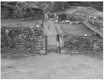
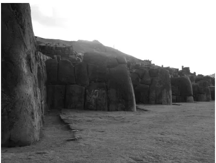
(48) 201. Figure 9-38: The fountain of Tambomachay.. 9.13 Sacsahuaman. The base of Sacsahuaman’s zigzag walls are located at S13°-30.50’; W071°58.91’ and 3595 masl.. Motifs and Features: Sacsahuaman is a multi-faceted complex and exhibits carved rocks, zenith and anti-zenith alignments, stairs, seats, niches, a water source, basins, a cave, and altars.. Niles (1999) feels that construction of Sacsahuaman (Figure 9-39) may have been started by Topa Inca and completed by Huayna Capac. Zuidema and Quispe (1973) state that Sacsahuaman was regarded as a temple of the sun. The orientation of Cusco with Sacsahuaman northwest and above it ensured the June solstice sun would first strike Sacsahuaman before illuminating the city..
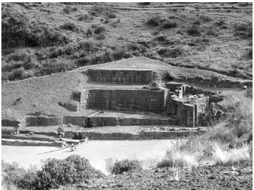
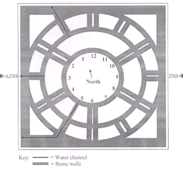
(49) 202 Zuidema says that a seat in Sacsahuaman is on a northwest/southeast line running from Ollantaytambo to Cusco and on to Lake Titicaca (personal communication).. Figure 9-39: Plan of Sacsahuaman (from D’Altroy, 2002).. 9.13.1 Muyucmarca. Above the zigzagged walls of Sacsahuaman (Figure 9-41) lies the foundation of a round building called Muyucmarca (Figure 9-40), which Zuidema describes as having three concentric round walls divided by interior walls and three gutters. He states that the central of three water channels, its opposing niche, and the walls that parallel them are all aligned along the axis of the.
(50) 203 zenith sunrise and anti-zenith sunset. Muyucmarca’s round tower and related buildings could have been used to observe the zenith sun overhead, as well as the horizon positions of the sunrise at zenith and the sunset at anti-zenith (Zuidema, 1981b: 326). Garcilaso (1961 [1609]: 287) says that Muyucmarca “…contained rooms with gold and silver painted walls, on which animals, birds, and plants figured in relief, as though in tapestry. It was here that the king lived when he came for a rest in the forest ….”. Figure 9-40: The zenith and anti-zenith alignments of Mayucmarca (from Zawaski, 2007:58)..
(51) 204. Figure 9-41: The zigzagged walls of Sacsahuaman..
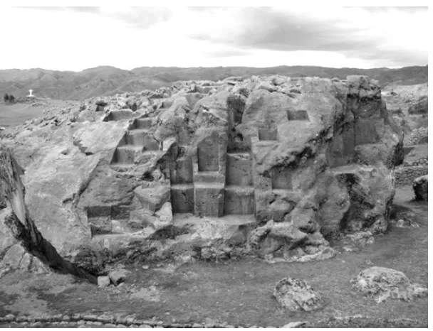
(52) 205 9.13.2 Tired Stone. The Tired Stone (Figure 9-42) is Piedra Casada (Ch 4:6).. [Ch-4.6] The sixth guaca was a large stone named Collanconcho which was in the fortress. They declared that, bringing it for that structure, it fell three times and killed some Indians. The sorcerers said that it had replied to questions they put to it that, if they persisted in wanting to put it in the structure, all would have a bad end, apart from the fact that they would not be able to do it. From that time on it was considered a general guaca to which they made offerings for the strength of the Inca (Cobo, 1990 [1653]: 56-57).. The limestone huaca is extensively carved with many examples of seats and stairs. Legend has it that as the massive stone was being brought to Sacsahuaman it became “tired” and could move no further (Hemming and Ranney, 1982). Van de Guchte (1990) argues the exclusion of the Tired Stone and the subsequent incompletion of Sacsahuaman to be intentional. This would leave the project’s completion for supernatural assistance. The Tired Stone is located at S13°-30.25’; W071°-58.86’ and 3610 masl.. Figure 9-42: The Tired Stone..
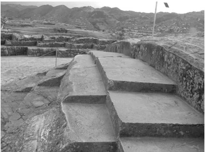
(53) 206. 9.13.3 Throne of the Inca. Across the plaza from Sacsahuaman’s ramparts is a huaca known as the Throne of the Inca (Figure 9-43), or Sabacurinca (Ch 5:6).. [Ch-5:6] The sixth guaca was named Sabacurinca; it was a well-carved seat where the Incas sat. It was very venerated, and solemn sacrifices were made to it. On account of this seat, the whole fortress was worshipped, for the seat must have been inside or next to the fortress (Cobo, [1653]: 57).. The series of massive steps or tiers were carved from diorite and are said to have served as a place where ruling Incas sat, in particular in a seat carefully carved for that purpose. The Throne of the Inca faces Cerro Huanacauri, the mountain mentioned with the procession and the pilgrimage in section 5.17. The Throne of the Inca is located at S13°-30.43’; W071°-58.93’ and 3618 masl.. Figure 9-43: The Throne of the Inca..
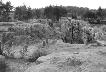
(54) 207 9.14 Mollaguanca. Mollaguanca is located at S13°-30.35’; W071°-58.74’ and 3581 masl.. Motifs and Features: Mollaguanca is a carved rock and was found to exhibit solstitial orientations, stairs, seats, and a water source.. To the east of Sacsahuaman lies a small huaca that may be Mollaguanca (Ch 3:6).. [Ch-3:6] The sixth guaca was named Mollaguanca; it was a certain stone which was in the middle of a flat place which they called Calispuquiu. Inca Yupanqui ordered it to be placed there and considered it a shrine (Cobo, 1990 [1653]: 55).. The crevasse in the center of the boulder (Figure 9-44) is aligned on the axis for June solstice sunrise and December solstice sunset. There are carvings of stairs and seats, but erosion is extensive thus leaving these potential orientations for June solstice sunrise and December solstice sunset inconclusive.. Calculated azimuth of June solstice sunrise from the center of the crevasse Measured azimuth from the axis of the crevasse to the horizon Measured Azimuth:. 068.0°. Magnetic Declination:. 3.9° W. True Azimuth:. 064.1°. Calculated JSSR Azimuth:. 065.0°. ∆ True Az & Calc JSSR Az:. 0.9°. Measured Inclination:. +3.0°.
(55) 208 Calculated azimuth of December solstice sunset from the center of the crevasse Measured azimuth from the axis of the crevasse to the horizon Measured Azimuth:. 248.0°. Magnetic Declination:. 3.9° W. True Azimuth:. 245.1°. Calculated DSSS Azimuth:. 246.4°. ∆ True Az & Calc DSSS Az:. 1.3°. Measured Inclination:. +4.0°. Figure 9-44: Mollaguanca..
(56) 209 9.15 Sapantiana. Sapantiana is located at S13°-30.73’; W071°-58.68’ and 3465 masl.. Motifs and Features: Sapantiana is a carved rock and was found to exhibit a water source, and an animal replica stone.. In a residential area below Sacsahuaman and within view of the Coricancha is a huaca known as Sapantiana (Figure 9-45). Homes have grown to surround this shrine that Bauer (1998: 53) says is the “best possible location for Ch 2:4.”. [Ch-2:4] The fourth guaca was called Viroypacha; it is a conduit of fairly good water which was declared a guaca by Inca Yupanqui. It was prayed to for the tranquility of the Inca (Cobo, 1990 [1653]: 54).. Figure 9-45: Sapantiana is currently surrounded by homes..
(57) 210 9.16 Rumiwasi Bajo. Rumiwasi Bajo is located at S13°-31.17’; W071°-56.42’ and 3470 masl.. Motifs and Features: Rumiwasi Bajo is a group of structures and was found to exhibit a solstitial orientation, niches, and a cave (tunnel).. To the east of Cusco above San Sebastián lies Rumiwasi Bajo. The rock of Rumiwasi Bajo contains a number of niches and a nine meter-long passageway. One doorway to the passageway through the huaca looks out close to the June solstice sunset, but is 12° off. The other doorway opens to the December solstice sunrise (Figure 9-46).. Figure 9-46: The southeastern door to the passageway of Rumiwasi Bajo..
(58) 211. Calculated azimuth of December solstice sunrise from the southeastern tunnel door Measured azimuth from the axis of the tunnel door to the horizon Measured Azimuth:. 116.0°. Magnetic Declination:. 3.9° W. True Azimuth:. 112.1°. Calculated DSSR Azimuth:. 113.9°. ∆ True Az & Calc DSSR Az:. 1.8°. Measured Inclination:. +2.0°. Calculated azimuth of June solstice sunset from the northwestern tunnel door Measured azimuth from the axis of the tunnel door to the horizon Measured Azimuth:. 286.0°. Magnetic Declination:. 3.9° W. True Azimuth:. 281.1°. Calculated JSSS Azimuth:. 294.4°. ∆ True Az & Calc JSSS Az:. 2.0°. Measured Inclination:. +12.3°.
(59) 212 9.17 Rumiwasi Alto. Rumiwasi Alto is located at S13°-30.97’; W071°-56.36’ and 3563 masl.. Motifs and Features: Rumiwasi Alto is a group of structures and was found to exhibit a potential solstitial orientation, niches, and terraces.. Another carved rock lies several hundred meters uphill, known as Rumiwasi Alto. The site includes four terraces bound by walls, one with four niches facing out to 195° (Figure 9-47). Several other niches have not survived. Rumiwasi Alto looks 13.5° down upon Rumiwasi Bajo at an angle of 206°. The walls of the terraces are aligned at 118° and nearby Kusicallanca is oriented with this site on the December solstice sunrise axis.. Calculated azimuth of December solstice sunrise from the central terrace wall Measured azimuth along the central terrace wall to the horizon Measured Azimuth:. 118.0°. Magnetic Declination:. 3.9° W. True Azimuth:. 114.1°. Calculated DSSR Azimuth:. 113.9°. ∆ True Az & Calc DSSR Az:. 0.2°. Measured Inclination:. +1.0°.
(60) 213. Figure 9-47: Walls and niches of Rumiwasi Alto..
(61) 214 9.18 Kusicallanca. Kusicallanca is located at S13°-31.02’; W071°-56.23’ and 3573 masl.. Motifs and Features: Kusicallanca is a group of structures and was found to exhibit a potential solstitial orientation, niches, and terraces.. Kusicallanca neighbors Rumiwasi Alto to the southeast. It exhibits three terraces with several masonry walls, including an upper one with two extant niches (Figure 9-48). The original wall likely contained two to four additional niches. The wall is oriented such that the December solstice sun will rise behind it.. Calculated azimuth of December solstice sunrise from the upper wall with two niches Measured azimuth perpendicular from the upper wall with two niches to the horizon Measured Azimuth:. 120.0°. Magnetic Declination:. 3.9° W. True Azimuth:. 116.1°. Calculated DSSR Azimuth:. 114.1°. ∆ True Az & Calc DSSR Az:. 2.0°. Measured Inclination:. +0.0°.
(62) 215. Figure 9-48: Wall with two niches at Kusicallanca..
(63) 216 9.19 Tipon. Tipon is located at S13°-34.25’; W071°-46.99’ and 3460 masl.. Motifs and Features: Tipon is a multi-faceted complex and was found to exhibit sacred rocks, a solstitial orientation, niches, a water source, fountains, a doublejambed doorway, and terraces.. Tipon is situated approximately 26 km to the southeast of Cusco and was an Incan city most likely originally known as Quispicanche. Zuidema (1981b: 331-335) argues Tipon to have been part of a ritual pilgrimage that took place at the time of the June solstice (see section 5.17). The modern village of Quispicanchis lies along the highway in the valley below Tipon. Wright (2006) suggests that Tipon was an estate for Inca nobility.. The site (Figure 9-49) includes two main sections, the lower area consisting of masonry structures, fountains fed by a mountain spring, and thirteen finely-constructed terraces (Figure 950). The upper area includes a complex of masonry structures with a shrine known as an Intihuatana. Further north is a ceremonial plaza, an aqueduct and a residential area. On the top of the mountain above the plaza is Limaqawarina (Zuidema, 1981b: 333). Upper sections of Cusco may be seen to the northwest from both Limaqawarina and the Intihuatana. Limaqawarina is on the zenith sunrise axis as viewed from the Chirao sucanca on Cerro Picchu and is the likely site of the Pucuy Sucanca (Zuidema, 1981b: 335)..
(64) 217. Figure 9-49: Plan of Quispicanche, or Tipon (Fidel Ramos, from Zuidema, 1981b: 334)..
(65) 218. Figure 9-50: The terraces of Tipon looking to the southwest. Iglesia Raqui is to the left and the Intihuatana is to the right..
(66) 219 Two structures are located above the eastern flank of the terraces. One is called Iglesia Raqui and the other is immediately adjacent to it on its northeast side. The structures are located at S13°-34.24’; W071°-46.95’ and 3476 masl. Iglesia Raqui has three windows and two doors facing out over the terraces and the opposite rear wall contains six windows. The northeastern structure has one door facing northeast, twelve interior niches and one window looking northwest over the terraces (Figure 9-51).. Figure 9-51: Structure immediately northeast of Iglesia Raqui..
(67) 220 Structures in the Intihuatana complex can be seen from Iglesia Raqui and the northeastern structure. The window in the northeastern structure faces out at 312° (Figure 9-52) and the Intihuatana is 297.4° from the structure, 1° from the predicted point of the June solstice sunset.. Calculated azimuth of June solstice sunset from Iglesia Raqui Measured azimuth from the northeastern structure to the intihuatana Measured Azimuth:. 301.5°. Magnetic Declination:. 4.1° W. True Azimuth:. 297.4°. Calculated JSSS Azimuth:. 298.4°. ∆ True Az & Calc JSSS Az:. 1.0°. Measured Inclination:. +13.0°. Figure 9-52: The Intihuatana as viewed from the window in the northeastern structure..
(68) 221 The Tipon Intihuatana differs from the intihuatanas at Machu Picchu, the River Intihuatana and Pisac in that those intihuatanas are all finely carved while Tipon’s consists of unimproved rocks (Figure 9-53). Similarly to the ones at Machu Picchu and Pisac, the Tipon Intihuatana is situated on high ground facilitating “access” to the sun. It is located at S13°-34.16’; W071°47.13’ and 3554 masl.. Calculated azimuth of June solstice sunset from the intihuatana Measured azimuth from the intihuatana to a raised feature on the horizon Measured Azimuth:. 298.0°. Magnetic Declination:. 4.1° W. True Azimuth:. 293.9°. Calculated JSSS Azimuth:. 294.4°. ∆ True Az & Calc JSSS Az:. 0.5°. Measured Inclination:. +1.0°. Figure 9-53: The Intihuatana of Tipon..
(69) 222 The Intihuatana stones lie at the southern end of a complex of associated structures and overlook much of the site below. Many of the structures near the Intihuatana are crumbling and are the subjects of current reconstruction efforts. Iglesia Raqui is at a 13° angle of depression from the Intihuatana (Figure 9-54). Tipon has a sightline aligned for the June solstice sunset that may have played a role in pilgrimage and ceremonies during the time of the festival of Inti Raymi. The Pucuy Sucanca of Quispicancha is oriented with the Chirao Sucanca at Picchu along the axis of the zenith sunrise and anti-zenith sunset (see section 8.8.2). Priests would pass through Quispicancha on their return from their pilgrimage to Vilcanota (see section 5.17). As with certain other Inca pilgrimage centers there could have been separate areas for elites and nonelites to view the solstice sunset. A double-jambed doorway on the trail leading from the terraces to the Intihuatana would indicate that only elites were permitted past this point (Niles, 1999: 295) and they alone would be able to view the sunset from the Intihuatana (Figure 9-55). Non-elites, however, could still have viewed the June solstice sun setting over the Intihuatana from a flat area near Iglesia Raqui, a location that could accommodate a large number of observers. The orientation of the June solstice sunset axis is shown in Figure 9-56.. Figure 9-54: The eastern mesa as viewed from the Intihuatana..
(70) 223. Figure 9-55: The horizon position of the June solstice sunset as viewed from Tipon’s Intihuatana..
(71) 224. Figure 9-56: The June solstice sunset could have been viewed over the Tipon Intihuatana from a mesa behind Iglesia Raqui (modified from Malville, 2008)..
(72) 225 9.20 Saihuite. Saihuite is located at S13°-32.82’; W072°-48.11’ and 3623 masl.. Motifs and Features: Saihuite is a multi-faceted complex and was found to exhibit carved rocks, light and shadow effects, a solstitial orientation, east-west orientations, stairs, seats, niches, a water source, fountains, platforms, animal replica stones, and channels.. Saihuite, well within the ancient territory of the Chanca and the modern province of Abancay, is situated some 160 km west of Cusco. The site’s Principal Stone is a striking rock of andesite that has been carved extensively. The stone’s upper half is completely sculpted with zoomorphic carvings as well as channels, possibly for fluids of divination.. The site is divided into upper and lower sectors and in addition to the Principal Stone includes the Rumihuasi ruins and an ushnu (Figure 9-57). The Principle Stone and a structure with several rooms and a large niche rest on a raised platform in the upper sector which is situated on a terraced hilltop called Concacha. Beyond this platform the terrain descends rapidly and a great multi-tiered fountain that includes a staircase was constructed down the side of the hill. Located in the lower sector are several features that include additional carved stones and a major platform..
(73) 226. Figure 9-57: Plan of Saihuite. The Principle Stone, or monolith, is to the left; to the east are the Rumihuasi; the Ushnu Pampa and Chingana; and the Third Stone. The fountain and stairs are on the hill between the monolith and Rumihuasi (Van de Guchte, from Staller, 2008: 300)..
(74) 227 9.20.1 Principal Stone. Saihuite is oriented generally southeast to northwest and the upper sector that includes the Principal Stone is at the northwest end of the site (Figure 9-58). The features of the upper sector rest on an earthen platform. The stone is extensively sculpted and is currently protected by a wrought-iron fence (Figure 9-59). Among the many fine carvings found on the stone are those of symbolic steps, pumas, lizards, frogs, snakes, llamas, humans and a monkey. Carvings are in high relief, but most have been mutilated, presumably during the period of the Spanish extirpation of idolatries (Hemming and Ranney, 1982; Paternosto, 1996). Van de Guchte (1990) argues the carvings of the Principal Stone to be a figurative landscape or map of the Inca Empire. The Principal Stone is located at S13°-32.84’; W072°-48.18’ and 3652 masl.. Figure 9-58: Saihuite’s upper sector and the corners of its earthen platform on the terraced hill of Concacha. The Principal Stone is nearest the southwest corner of the platform..
(75) 228. Figure 9-59: The Saihuite Principal Stone. A complex series of channels and cups begins at the top of the stone and is carved throughout (Figure 9-60). Ceremonial fluids would have been fed to the channels by hand. The rock may also have been given sentience through the power of camay by water flowing in these channels across its surface.. The Principal Stone lies with the adjacent structure on the axis of the June solstice sunrise and December solstice sunset..
(76) 229. Figure 9-60: Carvings of figures, stairs and fluid channels..
(77) 230 9.20.2 Upper Structure. Adjacent to the Principal Stone on the raised grassy platform is a structure with several rooms and a door with a niche facing to the southeast (Figure 9-61). The upper sector of Saihuite is predominantly oriented to the axis of the June solstice sunrise and December solstice sunset. The long retaining walls of the earthen platform measure approximately 064.3°/244.3° as well as do walls of the Upper Structure. The Upper Structure is located at S13°-32.83’; W072°-48.19’ and 3657 masl.. Figure 9-61: Elements of the upper sector of Saihuite..
(78) 231 The Upper Structure’s northeast face includes a corridor and niche that are oriented to view the June solstice sunrise (Figure 9-62). The niche is large enough that a priest could stand within it to view the events on the distant horizon (Figure 9-63). Additional features of the Upper Structure align on this axis as well.. Calculated azimuth of June solstice sunrise from the niche Measured azimuth along the axis of the niche and corridor to the horizon Measured Azimuth:. 067.5°. Magnetic Declination:. 3.2° W. True Azimuth:. 064.3°. Calculated JSSR Azimuth:. 065.3°. ∆ True Az & Calc JSSR Az:. 1.0°. Measured Inclination:. +2.0°. Figure 9-62: Niche and corridor aligned for the June solstice sunrise..
(79) 232. Figure 9-63: View in the direction of the June solstice sunrise from the niche..
(80) 233 9.20.3 Multi-Tiered Fountains. A set of 69 stairs and an adjacent multi-tiered fountains connect Saihuite’s upper and lower sectors (Figure 9-64). The fountain has 22 tiers oriented to 098°/278° with a 24° slope. The lower portion of the fountain complex has six sections of two-tier fountains, while the upper portion uses three sections of three-tier fountains. There is one additional fountain in a top tier. The original source came from the terrace above and markings on the stones would indicate that water has flowed through the fountain in modern times. The top of the fountain is located at S13°32.82’; W072°-48.14’ and 3640 masl, and the bottom is at S13°-32.82’; W072°-48.11’ and 3623 masl.. Figure 9-64: A multi-tiered fountain descends the slope leading to Saihuite’s lower sector..
(81) 234 9.20.4 Rumihuasi Stone. The Rumihuasi Stone lies in the Rumihuasi area of Saihuite’s lower sector (Figure 9-65). The stone is finely carved (Figure 9-66) on all sides and exhibits features in common with other sculptures such as the Ceremonial Rock of Machu Picchu (see Figure 11-37) and the River Intihuatana (see Figure 11-23). It exhibits shelves, seats and symbolic steps, as well as possible divination channels on its southern side (Figure 9-67). Fluids might have been poured into a cup on top of the rock to flow through a channel, first to a fork and then through either of two additional channels to small niches with drains. Paternosto (1996) writes that the stone is still used for marriage ceremonies, the bride and groom each drinking water from the two channels. I found no apparent celestial orientations in the Rumihuasi Stone and it now is split in two, perhaps as the result of an earthquake. The Rumihuasi Stone is located at S13°-32.77’; W072°-47.97’ and 3584 masl.. Figure 9-65: The lower sector of Saihuite..
(82) 235. Figure 9-66: The Rumihuasi Stone of Saihuite..
(83) 236. Figure 9-67: Ceremonial channels in the Rumihuasi Stone..
(84) 237 9.20.5 Chingana. The platform of Chingana (“where one gets lost”) in the lower sector is cardinally oriented (Figure 9-68), with the long walls measuring east-west and the shorter ones nearly north-south. The rear wall of the platform extends for 38 meters at 090°/270°. The front wall measures 091° and 271°. Both side walls are 21 meters long at 008°/188°. The staircase includes 16 steps that are eight meters wide and face 003°.. Platforms, as ushnus, were used for ceremony and sacrifice, but the specific function of this site remains unclear. It is a raised platform with stairs that has at its center a one square meter depression that may have served to drain fluids – two of the three elements typical of an ushnu. Chingana’s size would also make it suitable as a place to gather for viewing ceremonies held on Ushnu Pampa immediately to its north. On the north side of Ushnu Pampa (see figure 9-57) lays the remains of a considerably deteriorated platform called Rauraq’asa. Chingana is located at S13°-32.88’; W072°-47.89’ and 3565 masl.. Figure 9-68: Chingana in Saihuite’s lower sector. A depression can be seen in the center..
(85) 238 9.20.6 Third Stone. Paternosto (1996) says the Third Stone (Figure 9-69) was first published in 1972 by HébertStevens. Hemming and Ranney (1982: 176) refer to it as “a pumalike stone at Saihuite” in the caption of one of their photos. Paternosto (1996: 135) continues that “this Third Stone is the best instrument for watching the movement of the sun between the solstices, as the shadow projected by the stepped quarter-disc – the ‘gnomon’ – demonstrates.” Paternosto refers to following the shadow of the central arm as if it were a sundial depicting the extremes at solstices and without shadow at the equinoxes. Staller (2008: 298) says that the stone’s carvings are oriented in such a way that it can serve observation of the annual cycle of solar movement. As such it acts as a gnomon or pillar, the last of the three prescribed elements for an ushnu at Saihuite.. The Third Stone is finely carved on all sides. The axis of its central arm is 057°/237°, or a 33° difference from the 090°/270° east-west axis. The arm with a hole suggests potential use as an intihuatana, but the true purpose of the Third Stone remains enigmatic. The stone lies at the opposite extreme of Saihuite from the Principal Stone. The Third Stone is located at S13°-32.84’; W072°-47.79’ and 3545 masl.. Figure 9-69: The Third Stone..
(86) 239 9.21 Summary. The region outside of Cusco exhibits many fine examples of Inca astronomy encoded into its huacas and other structures. The “Eyes of the Puma” at Kenko Grande and the solar orientations within the huaca’s cavern readily demonstrate the Inca’s fascination with the sun and their propensity for utilizing their astronomical knowledge when constructing important shrines. No where better is this shown than within the caves of Lacco where their altars are illuminated by the sun or the moon at specific times of the year.. The huaca with two circles aligned for solar horizon events is especially interesting. The Incas seem to have designed multiple meaning and purpose into most everything they carved and this huaca is certainly no exception. The astronomical orientations of the circles and the sculpted seats are unmistakable and their use would have been a prominent feature of this site. The full significance of this huaca, however, is as of yet unknown and remains to be determined.. At Tipon the orientation for viewing of the June solstice sunset by elites and non-elites is intriguing as this becomes part of a potential emerging trend found in common with other pilgrimage sites. In Saihuite the axis between the horizon points of the June solstice sunrise and December solstice sunset dominates the upper sector of the complex..
(87)
Figure

+7
Outline
Related documents
Taffs and Holt (2013, p.501) state that “in order to be accessed, resources must match student needs as well as their expectations”, and a primary goal in the development of
For residents of all states except AL, AR, CO, LA, MD, ME, NJ, NY, OK, TN, VA, WA, WV and District of Columbia and Puerto Rico: Any person who knowingly and with intent to defraud
What this list shows is that buying from social enterprises isn’t just about the central procurement department – it is about every person who makes purchasing decisions in
For members participating in KERS, CERS, and SPRS, the amount of service credit used to determine retirement eligibility and benefits can include current service, prior
ON Semiconductor makes no warranty, representation or guarantee regarding the suitability of its products for any particular purpose, nor does ON Semiconductor assume any
January term is a month-long study of one particular subject that can occur on campus in traditional classroom settings or through domestic and international
We train fitness instructors to teach the public Boxercise Classes and Personal Training, running over 200 training course a year from different venues worldwide. In the UK
Bahan pangan yang dimaksud dalam penelitian ini adalah bahan pangan yang diperoleh dari tumbuhan yang tidak dibudidayakan (wild dan semi wild) yang digunakan
