Part III: Habitats
Chapter 21
Vulnerability of geomorphological features in the
Great Barrier Reef to climate change
21.1 Introduction
The Great Barrier Reef (GBR) is the largest contiguous coral reef ecosystem in the world81,49. That
it is possibly the largest geomorphological structure ever created by living organisms is less widely appreciated. The GBR extends through approximately 15 degrees of latitude and more than 2100 km along the northeast Queensland coast, covering an area of 344,500 km282. It includes more than
2900 reefs of varying types (eg fringing, patch, cresentic, lagoonal, planar), dimensions and stage of growth, which together occupy greater than 20,000 km2, or about 5.8 percent of the total area of the
GBR81,82. Three hundred or so coral cays, and more than 600 continental or high islands occur within
the GBR. The mainland coast, which can be broadly separated into sandy shorelines and mangrove-lined muddy coasts and estuaries (rocky coasts are far less common)80, is another important and
dynamic geomorphological component of the GBR.
The geomorphology and ecology of the GBR are strongly interdependent – the reefs are almost entirely the skeletal remains of a myriad of calcium carbonate secreting fauna and flora. A suite of organisms and ecological processes are involved in the production, consolidation, modification and redistribution of these products to form many of the GBR’s geomorphological features. Conversely, geomorphological features are important to reef ecology. They physically structure habitats for various biota and influence the distribution of physical processes (such as waves and currents) important to many reef organisms. At a larger scale, outer reefs separate the inner lagoon and open ocean, and control cross-shelf hydrodynamic energy gradients important for many species. Biogeographic and other influences are important156, but the extraordinary habitat complexity and biological diversity
found on the GBR can be largely attributed to the geographical opportunities of latitudinal and cross-shelf gradients provided by its impressive scale.
This chapter provides an overview of the vulnerability to climate change of five of the GBR’s major geomorphological features: i) coral reefs, ii) reef islands, iii) high island beaches and spits, iv) mainland sandy coasts, and v) mainland muddy coasts. The vulnerability of biota associated with these features is assessed in other chapters (Lovelock and Ellison chapter 9, Hoegh-Guldberg et al. chapter 10, Congdon et al. chapter 14, Fabricius et al. chapter 17, Sheaves et al. chapter 19 and Turner and Batianoff chapter 20). Vulnerability is defined as the degree to which a system or species is susceptible to, or unable to cope with, the adverse effects of climate change1.
Part
III:
Habitats
Chapter
21:
V
ulnerability
of
geomorphological
features
in
the
Great
Barrier
Reef
to
climate
[image:3.499.72.429.124.608.2]change
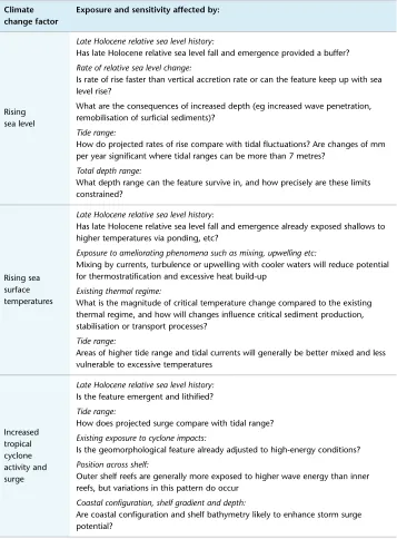
Table 21.1 Possible conditions affecting the exposure and sensitivity of different geomorphological features of the GBR to climate change factors
Climate change factor
Exposure and sensitivity affected by:
Rising sea level
Late Holocene relative sea level history:
Has late Holocene relative sea level fall and emergence provided a buffer?
Rate of relative sea level change:
Is rate of rise faster than vertical accretion rate or can the feature keep up with sea level rise?
What are the consequences of increased depth (eg increased wave penetration, remobilisation of surficial sediments)?
Tide range:
How do projected rates of rise compare with tidal fluctuations? Are changes of mm per year significant where tidal ranges can be more than 7 metres?
Total depth range:
What depth range can the feature survive in, and how precisely are these limits constrained?
Rising sea surface temperatures
Late Holocene relative sea level history:
Has late Holocene relative sea level fall and emergence already exposed shallows to higher temperatures via ponding, etc?
Exposure to ameliorating phenomena such as mixing, upwelling etc:
Mixing by currents, turbulence or upwelling with cooler waters will reduce potential for thermostratification and excessive heat build-up
Existing thermal regime:
What is the magnitude of critical temperature change compared to the existing thermal regime, and how will changes influence critical sediment production, stabilisation or transport processes?
Tide range:
Areas of higher tide range and tidal currents will generally be better mixed and less vulnerable to excessive temperatures
Increased tropical cyclone activity and surge
Late Holocene relative sea level history:
Is the feature emergent and lithified?
Tide range:
How does projected surge compare with tidal range?
Existing exposure to cyclone impacts:
Is the geomorphological feature already adjusted to high-energy conditions?
Position across shelf:
Outer shelf reefs are generally more exposed to higher wave energy than inner reefs, but variations in this pattern do occur
Coastal configuration, shelf gradient and depth:
Climate change factor
Exposure and sensitivity affected by:
Enhanced or reduced rainfall
Proximity to the coast:
Inshore areas are more exposed to flood impacts and changed sediment/ contaminant delivery to the GBR lagoon
Degree of enclosure:
Enclosed settings with poor mixing more exposed to lowered salinities
Nature of rainfall pattern change:
How do projected changes compare with existing rainfall patterns?
Degree of oceanic mixing:
Influence ameliorated where waters well mixed
Ocean acidification
Temperature and aragonite saturation state:
Acidification is likely to vary within the GBR as a function of temperature and alkalinity (see chapter 17)
An appreciation of the nature and rates of past environmental changes on the GBR provides an important starting point for assessments of how it might respond to climate change and of the significance of any adjustments. The geological record documents numerous cycles of sea level change of greater magnitude and pace than those predicted for the future, through which corals have survived and the GBR has repeatedly re-established158. Of course, optimistic assessments of coral reef resilience
to predicted environmental changes based on past survival must be tempered by acknowledgement of the extra pressures most now endure85,124,45. These issues are central to a longstanding debate about
whether reefs are robust (a geological perspective) or fragile (an ecological position). Reviews of this debate generally conclude that both positions are valid, with each having merit at appropriate temporal and spatial scales (eg Done38, Grigg57). Geomorphology is uniquely positioned to offer an integrative
perspective of reef condition that is at a scale appropriate for many climate change assessments.
21.2 Geomorphological features discussed in this chapter
21.2.1 Coral reefs
Numerous definitions of a coral reef exist, with varying emphasis on ecological and geomorphological attributes132,92. Coral reefs are commonly defined geomorphologically as biologically influenced,
wave-resistant structures composed of coral framework and carbonate sediments70. Most coral
reefs are dominated by calcium carbonate produced by corals, although coralline algae, molluscs, foraminiferans and various other organisms can be significant contributors. For a ‘true’ coral reef to develop the skeletal remains of these organisms must accumulate to form a deposit stable enough to resist dispersion by waves and currents. Biological influence on coral reef geomorphology is not limited to skeletal carbonate production – reef organisms also erode, transport, bind and consolidate reef materials51,84. The above definition emphasises coral framework as an important structural element,
but detrital facies are recognised as volumetrically more important on many reefs110,82. The production
Part
III:
Habitats
Chapter
21:
V
ulnerability
of
geomorphological
features
in
the
Great
Barrier
Reef
to
climate
change
The modern GBR began to grow after the last ice age when rising seas flooded the continental shelf. For many years it was believed that modern reef growth on the GBR started within a ‘narrow take-off envelope’ between 8300 and 7500 years ago31, but re-interpretation of detrital sediments at the base
of reef cores suggests a much broader initiation interval beginning as early as 9900 years ago82. Outer-
and mid-shelf reefs typically established on the limestone remnants of reefs formed during previous sea level highstands, the last of which occurred around 125,000 years ago94. Significantly, conditions
amenable for reef growth have existed on the central GBR shelf for about 15 million years32, but reef
cores suggest that coral growth began on the northern GBR only 600,000 years ago, and growth equivalent to modern reef growth did not begin until 450,000 to 360,000 years ago158. As reviewed
by Pandolfi and Greenstein (chapter 22), conditions suitable for reef growth have been the exception rather than the rule for much of the GBR’s history. For most of the time, reef growth was restricted to the deeper shelf edge by low glacial sea levels70,82. Just five or six highstands (each lasting less than
10,000 years) during which reef growth comparable to present could flourish have occurred during the GBR’s history158. Fluctuating sea level and associated environmental changes (often rapid and
abrupt) have dominated the GBR’s past (see chapter 22).
Comprehensive accounts of the tremendous geomorphological diversity observed across and between individual reefs within the GBR are available in Hopley70 and Hopley et al.82. This variety largely reflects
the ecological and geomorphological zonation of environmental parameters across reefs, and across the shelf and latitudinally74,36,37. Reef zonation is dynamic, changing as reefs grow or conditions
change. The concept of reef geomorphology progressing through an evolutionary sequence was introduced by Darwin29 for mid-ocean reefs, and was offered as a reason for the ‘gradational nature’ of
GBR shelf reefs by Maxwell114. Hopley70,72 extended Maxwell’s work and developed a morphogenetic
classification that explains differences in reef morphology as a function reef evolutionary stage. At the simplest level three broad classes were identified, each largely determined by the depth and size of a reef’s foundations, and its relative sea level history:
• Juvenile reefs: reefs not yet at sea level, perhaps because they have risen from deep foundations or started growing late.
• Mature reefs: reefs with established reef flats but retaining a lagoon, possibly because reef foundations were larger or deeper than for senile reefs.
• Senile reefs: reefs with infilled lagoons and planar reef tops, usually formed over small and shallow foundations subject to late-Holocene sea level fall (Figure 21.1).
Under stable sea level conditions reefs will develop through this sequence to a natural point of senescence. Approximately 2080 of the GBR’s 2900 named reefs are easily classified with this morphogenetic scheme (ribbon and fringing reefs cannot), with around half at the juvenile stage (submerged and patches), and 25 percent at both the mature (crescentic and lagoonal) and senile (planar) stages. The spread of reef types at various stages in the evolutionary sequence is therefore suitable for the continued maintenance and development of habitat diversity and function. However, broad regional patterns in foundation depth, relative sea level history, and thus reef stage and morphology occur70,81,82. Therefore some reef types are spatially concentrated and are vulnerable to
Figure 21.1 Shelf reef classification and summary statistics (after Hopley et al.82)
Radiocarbon ages from reef cores and reef flat microatolls indicate that reefs can rapidly move through the evolutionary sequence. For example, many inner northern GBR reefs progressed from submerged reef patches to planar reef tops in a few thousand years153,137. Simple models using
present-day carbonate production rates suggest very small lagoonal reefs may become planar reefs in under 500 years, and larger reefs of 20 km diameter (greater than 300 km² area) with 10 metre deep lagoons can reach senility in less than 6000 years82. Significant environmental and ecological
change would accompany this intrinsic geomorphological development. Well-flushed submerged ‘catch-up’ reefs116 with luxuriant growth over the platform would become increasingly enclosed and
dominated by detrital sediments. The outer reefs had their most vigorous period of growth between approximately 8500 and 5500 years ago, since then their structural and ecological diversity has progressively declined82. As noted above, about 25 percent of GBR shelf reefs are near the end of this
sequence.
Fringing reefs cannot be easily classified using Hopley’s70 evolutionary scheme, and due to their
proximity to land are widely perceived as especially vulnerable to changes in terrestrial conditions. Clearly, however, many fringing reefs on the GBR have long been exposed to a range of terrestrial influences, and their sensitivity to these may actually be relatively low. Smithers et al.143 noted that the
Part
III:
Habitats
Chapter
21:
V
ulnerability
of
geomorphological
features
in
the
Great
Barrier
Reef
to
climate
change
factors, although climate fluctuations were argued to modulate reef growth rates. Second, several of these senile reefs have not significantly changed size for thousands of years despite supporting healthy coral communities in historical times. These results demonstrate the long-term resilience of coral reef structures through prolonged periods of diminished carbonate production, and the pitfalls of assuming simple relationships between coral community condition and reef growth and maintenance.
21.2.2 Reef islands
Reef islands (cays) are low-lying accumulations of reef-derived sediments, portions of which may be lithified, deposited on reef platforms at or close to sea level. They form where waves refract around and over reefs and converge at a focal point on the reef platform where sediments are deposited54,79. Cays
are generally absent from larger reefs or those with a geometry that impedes centripetal wave refraction. The long-term development of reef islands in areas of dense reef network is similarly constrained, as low ambient wave energy cannot effectively concentrate sediment deposition54. Sand cays formed
under ambient wave and climate conditions typically accumulate near the leeward edge of the reef platform, whereas those composed of coarser sediments moved during storms usually form closer to the windward reef edge. Gourlay54 presents an excellent summary of reef island formation processes.
The geomorphology of reef islands on the GBR is varied, reflecting the range of latitude and climate, the variable geometries and relative sea level histories of the reefs on which they form, and the diversity of sediments of which they are composed79,82. Detailed descriptions of the reef islands found
on the GBR are presented in Hopley70,79 and Hopley et al.82. Unvegetated sand or shingle cays are the
simplest reef islands geomorphologically, and usually the youngest and most dynamic. The complex low wooded islands composed of a windward shingle island, a leeward sand cay, and varying degrees of mangrove development over the intervening reef platform, are typically the most complex and stable. Surprisingly few reef islands on the GBR have been subject to detailed geomorphological investigations.
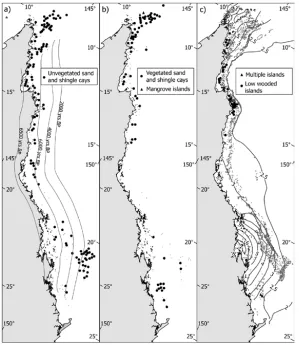
Most (72.7%) reef islands on the GBR occur on planar reefs that are concentrated north of 16° S and between 21 and 22° S, including almost all (97.6%) vegetated cays and low wooded islands. Importantly, approximately 60 percent of planar reefs presently do not support reef islands, and reef islands are not restricted to planar reefs. For example, 42 unvegetated cays occur on reef patches. Figure 21.2 shows the distribution of the major types of reef island on the GBR. More than 70 percent of reef islands on the GBR are unvegetated cays, with most located north of Cairns. They are also particularly common on the Swain Reefs between 21 and 22° S. A few unvegetated cays are located on the outer reefs (eg Sand Bank numbers 7 and 8), but only where protection exists70. Unvegetated
cays are not found between Wheeler Reef in the central GBR south to the northern Pompey Reefs (a distance of 315 km). This absence probably reflects the high tidal range (approximately eight metres near Broad Sound; see section 21.3.1), and greater exposure to both normal and cyclonic waves on this section of the reef70,127.
Figure 21.2 Distribution of different types of reef islands in the GBR (after Hopley et al.82). Isobase lines indicate approximate time when modern sea level was reached in panel a, and approximate tidal range in panel c.
Several vegetated cays are located on the far northern outer barrier (Tydeman Cay, an unnamed cay on a reef at 13° 22’ S, Moulter Cay and Raine Island), but none exist on outer barrier islands outside this province. The distribution of complex low wooded islands is strongly associated with the location of smaller planar reefs with emergent reef flats that are concentrated on the inner shelf north of Cairns. Ninety-four percent are within 20 km of the mainland, and all lie west of (inside) the zero hydro-isostatic isobase and have experienced relative sea level fall since the mid-Holocene21,71 (see
section 21.3.1).
The confinement of GBR reef islands inside the zero hydro-isostatic isobase raises the question of whether relative sea level fall is required for reef islands to form. Kench et al.89 suggested that some
Part
III:
Habitats
Chapter
21:
V
ulnerability
of
geomorphological
features
in
the
Great
Barrier
Reef
to
climate
change
Radiocarbon-dated fossil microatolls underlie many of the reef islands investigated on the GBR106,147,
suggesting that most developed after the reefs had reached sea level18,21. Reef islands on the Cocos
(Keeling) Islands, Indian Ocean, similarly exist over fossil reef flat foundations that became emergent as sea levels fell during the late Holocene170. Dickinson35 proposed that wave-resistant emergent
palaeoreef flats strongly influenced the development of stable reef islands on many Pacific atolls, but acknowledged that less stable ‘unpinned’ reef islands are common on reef flats that remain flooded by lower tides.
If radiocarbon chronologies are correct, rapid sand production, delivery, and cay deposition occurred on many planar reefs of the GBR between 4000 and 3000 years ago, with only relatively minor modifications since. However, AMS radiocarbon dating of a sandy reef island in Torres Strait indicates that mid-Holocene ages may be an artefact of age determination on bulk sand samples; ages of molluscs indicate sustained incremental accretion of Warraber Island over the past 3000 years172.
Island nuclei deposited during this earlier accumulation phase are often indicated by the presence of mature vegetation and greater soil development (eg Douglas Island and Masthead Island63), although
Woodroffe and Morrison169 found no clear relationship between soil development and age at Makin
Island, Kiribati. Significantly, most stable reef islands form over reefs in or entering the senile stage of geomorphological development. Factors that promote reef advance through the evolutionary sequence are therefore important drivers of reef island formation. Reef island formation has not ceased on the GBR, and new reef islands will form if reef growth and sediment production continues. Excluding the ribbon, incipient fringing and true fringing reefs (which are not easily accommodated in Hopley’s70 morphogenetic classification), about 26 percent of reefs on the GBR are planar, 13 percent
are lagoonal, 12 percent are cresentic, 21 percent are patches and 27 percent are submerged (Figure 21.1). Average estimates of the time required to progress through this sequence were discussed in the preceding section, but we emphasise that small shallow lagoonal reefs can transform into planar reefs in as few as 250 years82. Thus, where sediment supply is adequate and reefs are of suitable elevation,
geometry and energy exposure exist, reef islands may form quite rapidly.
Reef island morphology and location on a reef platform can be sensitive to changes in wave energy and direction, associated with both normal variability in ambient conditions and infrequent extreme events such as cyclones47,48. Island responses vary from total obliteration, shifts in size, shape and
position, or shifts between predictable morphological states. Changes in sediment type, supply or erosion, and in the extent of lithification, may also modify reef island morphology149,178. Almost all
descriptions of unvegetated cays on the GBR note that they can rapidly and markedly change shape, size, elevation and position152,69,70,3. Compact unvegetated sand cays are especially dynamic, with
several disappearing in historical time. Hopley70 reported the example of a cay on Pixie Reef, near
Cairns that was about 45 metres in diameter in 1928, but had split into two cays 65 metres apart by 1929. Reef top sediments at Pixie Reef in the early 1980s were completely dispersed, with not even a discrete sand bar visible.
The most detailed account of compact unvegetated cay behaviour on the GBR exists for Wheeler Cay69, a normally oval cay, around 80 by 50 metres in size, located over an area of sanded reef flat
included a three-hour storm with gusts to 60 knots, and the whole cay moved six metres on another day under light winds of less than 10 knots. Wheeler Cay had moved and changed shape again by 1980, but remained within the original sanded reef flat area3.
The most stable reef islands typically occur on small to medium-sized reefs, with larger cays usually more stable than smaller ones. Vegetation is indicative of some stability and may also improve or maintain stability in various ways. Relatively large cays on the GBR are unvegetated compared to other reef areas in the world. For example, Waterwitch Cay is 2.8 hectares was unvegetated when visited in 1973, but all cays larger than 0.1 hectare on the Belize barrier are vegetated, and at Kapingamarangi Atoll all islets greater than 0.01 hectare support terrestrial plants146. This difference may reflect the
larger tidal ranges, cyclone exposure, and possibly greater mobility of reef islands on the GBR. These constraints are particularly limiting on the central GBR.
Many stable reef islands are partially lithified, a process requiring at least temporary stability to occur145,147, and which may impart improved stability in the longer term137. Beach rock is common
on GBR reef islands, and forms a hard shoreline resistant to erosion. However, even large islands with extensive beach rock can be destabilised. For example, at Waterwitch Cay massive beach rock outcrops suggest previous periods of moderate stability, but at present the cay is barren, undoubtedly mobile, and disjunct from these lithified former shorelines. The cementation of cay sediments by phosphate solutions derived from guano to form phosphate rock is another lithification process that can improve reef island stability. Phosphate rocks mainly form above the high tide mark and in island interiors where birds may congregate. Where phosphate rock is well developed, such as at Raine Island, the island core becomes hardened and prospects for enduring island stability are improved, although unconsolidated beaches may remain dynamic.
21.2.3 High island beaches and spits
More than 600 high islands – continental outcrops separated from the mainland when the sea flooded the continental shelf after the last ice age – occur within the GBR. Many high islands have beaches, particularly in leeward embayments. Some of these beaches are fringed by reef and dominated by carbonate sediments (eg northwest end of Curacoa Island). Others are dominated by terrigenous sediments and have no fringing reef offshore (eg Horseshoe Bay, Magnetic Island). Beach rock is common on carbonate rich beaches, with lithified sediments varying from sands through to coarser shingle and rubble.
Many high islands, especially in the central GBR, have large leeside spits, many features of which are similar to the low wooded islands. The spit at Dunk Island, for example, extends more than 1200 metres along its central axis. Spit morphology is generally consistent with wave refraction around the islands and surrounding reefs. Most spits are dominated by terrigenous sediments, including boulders deposited during high-energy events. Hopley73 concluded that larger spits were not Holocene
deposits, but were multi-generational features formed over several previous sea level highstands. The soil development and elevated interiors of many spits are compatible with greater antiquity and formation during previous highstands when sea levels were higher than at present94. Many of these
Part
III:
Habitats
Chapter
21:
V
ulnerability
of
geomorphological
features
in
the
Great
Barrier
Reef
to
climate
change
(eg Curacoa Island and Rattlesnake Island). These ridges preserve a history of severe (greater than category 3) cyclone impact extending back to the mid-Holocene. These records show that severe storms affect most places on the GBR on average every 200 to 300 years, and that this recurrence interval has not significantly varied for the past 6000 or so years61. Nott and Hayne120 have argued
that this recurrence interval is significantly shorter than that calculated from instrumental records (and used in IPCC climate change projections), and suggests severe storms occur frequently enough to significantly influence coral communities and reef development.
21.2.4 Mainland sandy coastlines
Much of the mainland coast inside the GBR is sandy, composed of siliciclastic sediments derived from coastal catchments. Most of the sandy coastline may be geomorphologically described as either beach ridge plain or coastal sand barrier, with coastal dunes locally associated with both. Beach ridges are coastal sand ridges emplaced by waves, with sequences developing as successive ridges are emplaced on a prograding coast150,151. The mechanisms of beach ridge formation are debated, with
pulsed sediment supply2 and storm emplacement119 the two main theories. Barrier systems may be
broadly described as coastal sand deposits worked onshore by the transgression, but separated from the hinterland by an estuary or wetlands.
Beach ridges trail north from the mouth of almost every stream along the coast, typically forming a plain around 500 metres wide of up to 10 ridges. Much wider sequences have developed adjacent to major rivers. At the Haughton River, for example, a beach ridge plain of greater than 100 ridges is more than five kilometres wide. Beaches on exposed parts of the central Queensland coast typically develop a steep, coarse-grained, reflective upper profile and a lower gradient, fine-grained, dissipative lower profile. North of Cairns, wave energy is reduced because the barrier reef is closer. Sandy beaches with narrow beach ridge plains (generally less than one km) separated by rocky headlands occur along this coast. Most beach ridges on the GBR coast are Holocene in age, but some remnants of Pleistocene barriers exist65.
High wave energy and lower tidal ranges are normally associated with barrier development, but more than 30 barrier systems occur on macrotidal sections of the central Queensland coast. Further north, near Kurrimine, a multiple barrier system up to 12 km wide occurs, in which at least three phases of progradation can be recognized from the orientation of ridge crests56. Ridges exposed to prevailing
south-easterly winds commonly develop a dune cap, with higher ridges developing at the north of exposed beaches.
Several of the largest coastal dune fields in tropical Australia occur on Cape York, especially at Newcastle Bay, Orford Bay, Cape Grenville (400 km2), Cape Flattery (700 km2), and Cape Bedford.
Most of the beach ridge and barrier systems on the mainland GBR coast underwent a phase of active accretion and progradation during the late-Holocene56, which did not continue to present in some
locations. For example, mangrove muds of 2000 to 3000 years age interpreted as being originally deposited in the lee of seaward beach ridges now locally outcrop on exposed sections of the central and northern GBR coasts175. These muds have been uncovered by coastal retreat, which clearly should
not be assumed to be a recent phenomenon, or anthropogenically forced.
Carbonate sediments occur on beaches adjacent to mainland fringing reefs, which are mainly concentrated around the Whitsunday Islands and further north around Cape Tribulation. Carbonates are subordinate to siliciclastic sediments even at these locations. Massive beach rock like that on offshore reefs and high islands may form where carbonates are well represented, such as at Hydeaway Bay in the Whitsunday region, but is relatively uncommon.
21.2.5 Mainland muddy coastlines
Muddy shorelines on the mainland coast are most common in north-facing bays protected from the prevailing south-easterly winds. In these areas the inshore sediment prism, a body of fine sediment trapped in the nearshore zone, can encroach onto the shoreline. On exposed coasts resuspension prevents the landward edge of the prism extending further inshore than the five metre isobath97.
A series of characteristic geomorphological zones develop on these muddy coasts42 (see chapter
9). Broad salt flats usually dominate the supratidal and upper intertidal, with freshwater marshes developing in higher rainfall areas. Sequences of shelly or coarse sandy ridges (known as cheniers) occur on many salt flats, a legacy of episodic cyclones in these normally low-energy environments19,8.
At Princess Charlotte Bay, Chappell et al.21 estimated that storms capable of depositing a chenier have
occurred about every 80 years since the mid-Holocene. Near Sandfly Creek in Cleveland Bay (central GBR) at least four ridges can be identified within one kilometre of the active mangrove muds. The rear ridge is around 3700 years old and the most seaward 1400 years old, yielding a late Holocene progradation rate of about 0.5 metres per year17. Seaward of the salt flats a mangrove fringe usually
occurs, the exact elevation of which varies locally. At Cocoa Creek, near Townsville, it lies between the mean low and high water spring tide levels173. Seaward of the mangroves are broad bioturbated
mudflats, often with significant seagrass meadows. Tidal creeks incise back into the salt flats in many areas. Heap et al.62 provide excellent descriptions of many of these systems on the GBR coast.
Part
III:
Habitats
Chapter
21:
V
ulnerability
of
geomorphological
features
in
the
Great
Barrier
Reef
to
climate
change
21.3 Exposure and sensitivity to major climate change stressors
21.3.1 Sea level rise
21.3.1.1 Post glacial sea level history.
Understanding sea level history is important for evaluating the vulnerability of the GBR to climate change for several reasons. First, detailed sea level histories can inform interpretations of how future sea level changes on the GBR might differ from predicted average global rates. Second, they provide a context for interpreting previous reef development and how reefs may respond to future change. Third, identification of features formed at higher sea levels, such as emergent palaeoreef flats35
(section 21.2.2), allows recognition and consideration of physiographic regions and possibly process thresholds for inclusion in climate or sea level change response models. Reported rates of historical and future sea level change are generally global averages derived from a globally aggregated instrumental data set. A rate of rise around 1.7 mm per year is typically quoted for the past century, accelerating since 1993 to around 3 mm per year25. Assessments of the exposure and sensitivity
of geomorphological features of the GBR to possible future sea level changes should consider the regional pattern of relative sea level change as this is the sea level signal to which the system will respond. Regional and global signals may differ due to a variety of mostly dynamic earth (isostatic) and ocean (temperature, density, wind and atmospheric pressure) factors.
The precise details of elevation and chronology vary spatially, but sea level was close to present by around 6500 years ago along much of the inner GBR, before rising a further metre or so by 6000 years ago and then falling to its present level68,21. Subtle flexure of the continental shelf in response to
loading with seawater during the postglacial transgression (hydro-isostasy) produces this pattern115.
Hydro-isostatic flexure occurs about a hinge line (the zero isobase20), to the east of which the shelf
has subsided and relative sea level has risen, and to the west of which the shelf has flexed upward and relative sea level has fallen. This history has two major implications for assessments of future vulnerability. First, the inner GBR has experienced relative sea level fall for several thousand years, with intertidal communities formed in the mid-Holocene often elevated around a metre above their modern equivalents21. Second, different locations across the shelf have different sea level histories that
may affect their response to future climate changes71,115.
Geomorphological responses to postglacial sea level changes prior to the mid-Holocene highstand are also relevant to vulnerability assessments. During the last deglaciation at least two periods of rapid and sustained sea level rise forced by ice-sheet decay and melt-water discharge occurred. The
two best-known events are melt-water pulse 1A (MWP-1A) and melt-water pulse 1B (MWP-1B)46,4.
MWP-1A is accepted as ‘a real feature of the postglacial eustatic sea level history’159, beginning about
14,500 years ago, after which sea level rose by 40 to 55 mm per year for around 500 years46. The
details of MWP-1B and other melt-water pulses179,26,10 are less certain138,6,174. Reef growth on the GBR
was limited to the continental slope during both MWP-1A and 1B by low sea levels, and thus they did not affect the contemporary GBR. Shelf reefs had established by 7600 years ago, but no convincing evidence of the melt-water pulse speculated then exists on the GBR82. Although direct evidence from
the GBR is lacking, reefs clearly survived rapid sea level rise during MWP-1 events at Barbados and Tahiti46,5, confirming the capacity of healthy reefs to endure sustained episodes of sea level rise at rates
21.3.1.2 Tide range and wave exposure
The sensitivity of geomorphological environments to sea level changes in the order of millimetres per year is influenced by the variability of the ambient water level signal to which they are adjusted. Generally, ‘noisy’ environments – such as where waves and or tidal range are high – are less sensitive (Lovelock and Ellison chapter 9). Within the GBR, tidal range varies with latitude and across the shelf, ranging between 3.6 and 2.5 metres from Torres Strait to Cairns, but exceeding eight metres at Broad Sound on the southern GBR coast (refer to Figure 21.2c). The spring tidal range at the shelf edge is typically about three metres. The present-day wave climate is similarly variable, with smaller waves where the outer barrier is best developed and where fetch inside the barrier is limited. The hydrodynamics of the GBR are summarised in detail in Hopley et al.82. We emphasise that
contemporary conditions are not always the same as those that have prevailed in the past, or during important periods of ecosystem or geomorphological development. For example, Hopley73 suggested
that boulder beaches and spits inside the central GBR were reworked by larger waves during the ‘Holocene high-energy window’ – a short interval in the mid-Holocene when the outer barrier lagged sea level and oceanic waves entered the GBR lagoon. Tidal ranges within the GBR have also been modified as sea level, reef, and coastal configurations changed through time.
21.3.1.3 Other background sea level variability
Superimposed over longer-term sea level fluctuations, and shorter ones such as tides, are other ocean-atmosphere phenomena with a range of frequencies and amplitudes, such as the El Niño-Southern Oscillation (ENSO), the Pacific Decadal Oscillation, and the Interdecadal Pacific Oscillation. For example, sea level in the Western Pacific can oscillate by about 0.5 metres as the ENSO shifts from El Niño to La Niña over cycles as short as four to six years177,60. Such variations are another source of
natural variability that may temper sensitivity to slower rates of predicted sea level change.
21.3.1.4 Depth range, bathymetric relief and topography
The exposure and sensitivity of geomorphological features will vary according to the breadth of the depth range in which they form. For example, coral reefs capable of flourishing within a 30 to 50 metre depth window are less sensitive to rising seas than reef islands, which form and persist within a much narrower vertical range. Especially on low gradient parts of the GBR, it is important to recognise that marked lateral shoreline translations may accompany sea level rise. In some areas shorelines may simply migrate across similar deposits emplaced in the late Holocene, but complex re-organisation of the coastal zone may ensue elsewhere.
21.3.2 Rising sea surface temperature
Part
III:
Habitats
Chapter
21:
V
ulnerability
of
geomorphological
features
in
the
Great
Barrier
Reef
to
climate
change
Thermal stress will not be uniform across the GBR, or across habitats at smaller scales (eg reef front compared to lagoon). It will vary according to tolerances developed in response to the present-day thermal regime, with tolerance to three–day hot spells most critical for coral bleaching9. The magnitude
and rate of temperature changes over the past century may also be important (Lough chapter 2, Lovelock and Ellison chapter 9, Fabricius et al. chapter 17), with corals in the south of the GBR experiencing warming by 0.7°C since 1903 – almost double the 0.4°C experienced on the northern GBR64 (Fabricius et
al. chapter 17). This geographic difference is further revealed by comparison of the mean maximum SST for both the northern and southern GBR for 1910 to 1919 and 1990 to 1999. This analysis shows a 0.6°C SST rise on the southern GBR but no change in the northern GBR (Lough chapter 2).
Surface water heating is the main cause of thermal stress, and greatest exposure occurs where surface waters are weakly mixed by waves and currents, have longer residence times, and do not receive cooler upwelling. However, it is important to note that for coral reefs, for example, bleaching is most highly correlated with three–day hot spells rather than mean or median conditions9, and thus only short-term
exposure is required for significant stress impacts to occur. At smaller scales, organisms living where water may stagnate, such as in enclosed embayments, lagoons or ponded reef flats, may experience more critical stresses than on reef fronts and flanks where active hydrodynamic mixing takes place. The physiologically damaging effects of ultraviolet-A and ultraviolet-B radiation164 will also vary spatially
due to mediation associated with hydrodynamic mixing and water column properties. Inshore turbid zone reefs may be less exposed than those in clearer waters where damaging radiation can penetrate to greater depths78.
The sensitivity of different organisms to rising SSTs is a common theme in preceding chapters. Geomorphological features that rely directly or indirectly on ‘sensitive’ organisms to produce materials, or to undertake or facilitate important geomorphological processes are most exposed and sensitive to these impacts. The sensitivity of most features has not been adequately established, but coral reefs are an obvious example. Corals have bleached repeatedly in recent decades due primarily to elevated SSTs, and projections suggest that the capacity of reefs on the GBR to maintain significant coral communities will be largely lost as SSTs rise40. Although this outcome may be catastrophic ecologically, and will
inevitably produce some geomorphological modification, the medium- to long-term geomorphological significance of these changes remains unquantified. With other stresses (eg acidification, increased storm frequency) rising SST will probably lead to increased mortality and availability of a new pulse of sediment on many reefs (see Sheppard et al.139).
21.3.3 Increased cyclone activity
Tropical cyclones have two major impacts on geomorphological features of the GBR: i) direct damage through storm waves, and ii) extreme cyclonic rainfall that generates floods delivering freshwater, sediments and nutrients to the GBR (exposure and sensitivity to rainfall are discussed in section 21.3.4). Tropical cyclones can devastate coral and other communities, but they are important constructional events for several geomorphological features. Storm blocks, shingle ramparts, and detrital facies are common geomorphologic features that document a long-history of storm exposure on the GBR136.
Cheniers and beach ridges along the mainland coast similarly record episodic cyclone impacts in the recent geological past119. Severe tropical cyclones have occurred about once every 200 to 300 years on
average for the last 6000 or so years over most of the GBR24,61,120, and these events may be mechanically
Many tropical coastal habitats are adapted to periodic cyclonic disturbances, with robust communities and structures in higher-energy settings better able to physically withstand periodic cyclonic impacts27. Exposure to physical destruction by cyclone waves thus tends to show strong cross-shelf
variation, being lowest where reef configuration limits fetch and/or attenuates waves as they cross the shelf. However, this decline in exposure occurs against a corresponding increase in sensitivity. Corals on inshore reefs tend to have weaker skeletons and can be less firmly attached to the reef structure. The reef structure may also be weakly consolidated142,125, and potentially more sensitive and vulnerable
to damage.
An increase in the destructiveness and intensity of cyclones in recent decades has been argued and linked to climate change44,160, although the completeness of the underlying data is questioned95,96.
Increased cyclone activity will raise the exposure of more frequently affected reefs. The physical sensitivity of structures should not vary markedly from the present-day pattern in the short term, but accompanying changes in community structure are predicted which may have variable effects. Reefs dominated by fragile forms will be most sensitive initially, but as community structure changes and massive and encrusting corals with a higher probability of surviving wave damage dominate39, this
effect may diminish. Geomorphological features reliant on sediments produced by fragile assemblages will be sensitive to this structural transformation. Coral shingle is an important contributor to many geomorphological features (eg ramparts and beaches), and with a high surface area to volume ratio may be a major and relatively dynamic producer of coral sands. Projected general reductions in calcification and simplification of coral communities may significantly modify sediment budgets, especially where post-event community recovery slows and the interval between storms shortens. Under this scenario, geomorphological features that have historically been constructed by cyclones may be eroded in the longer-term future.
Patterns of exposure and sensitivity for inter- and supratidal geomorphological features like reef islands and sandy beaches differ from those of reefs, and are likely to be affected more by factors such as tidal range and late Holocene sea level history. For example, many reef islands on the inner northern GBR are located over emergent reef platforms (see section 21.3.1), and are protected by lithified ramparts. These islands are less exposed and sensitive to changed cyclone activity than unconsolidated cays on lower reef flats. By their very nature, sandy beaches are sensitive to changes in hydrodynamic environment and sediment supply, and move toward an equilibrium profile that is largely a function of these two parameters.
21.3.4 Enhanced rainfall
Climate change projections suggest that increased cyclone activity will produce more frequent high intensity rainfall events against a more general drying of most coastal catchments (Lough chapter 2). This change may expose geomorphological features to three interrelated impacts: i) increased frequency of freshwater flood plumes, ii) increased delivery of sediments to the coast, and iii) increased exposure to elevated nutrients and contaminants. Inshore geomorphological features will be most exposed, however as these environments have been episodically affected by similar events in the past their sensitivity should be relatively low. However, water quality has declined historically in many parts of the inner GBR33,11,45, and it is uncertain whether past resilience to plume impacts has
Part
III:
Habitats
Chapter
21:
V
ulnerability
of
geomorphological
features
in
the
Great
Barrier
Reef
to
climate
change
More frequent large plumes may extend further offshore and increase the exposure of offshore reefs. Cyclonic rain produced a large flood plume from the Fitzroy River in 1992 that lowered salinity over shallow reefs on the Keppel Islands and reduced live coral cover by 85 percent155. The sensitivity of
inshore communities other than coral reefs have been discussed in other chapters, and will affect the sensitivity of associated geomorphological features such as sandy or muddy coastlines. As an example, reductions in mangrove or seagrass cover may affect patterns of sediment deposition, erosion and transport70,154.
Changes in both sediment availability and transport potential may affect sediment delivery to the coast. Terrestrial and marine records in the region indicate that sediment yields are highest when dry conditions are followed by episodic high intensity rain events, especially where drought reduces vegetation cover and increases catchment vulnerability to erosion103. The sensitivity of inshore
communities to increased supply of fine sediments should be low, as they already experience high turbidity due to wind and wave resuspension of the inshore sediment prism98,99. Where excessive
sediment is delivered, currents may struggle to transport it all away and some smothering may result. This is most likely in sheltered locations, or near stream mouths163. Where flood plumes deliver
suspended sediments beyond their present range, sensitivities may be higher. Delivery of sand to the coast may also increase, but this will take longer, and the amount of new sediment delivered will still be relatively small compared to the amount accumulated over the last 6000 years97. Sands are
unlikely to be transported far offshore, but may be redistributed alongshore7,126, possibly renewing
beach ridge progradation in some areas.
21.3.5 Reduced rainfall
A major impact of reduced general rainfall but episodic high intensity events will be reduced vegetation cover and an increase in terrestrial erosion, with accompanying water quality reductions if nutrient and contaminant yields during floods remain high. The sensitivity of geomorphological features to reduced rainfall will also be influenced by the extent to which attributes such as vegetation that rely on regular freshwater are involved in enhancing stability or other important processes. For example, where insufficient rain falls to replenish aquifers or keep vegetation alive, cays may become more vulnerable to erosion, or less likely to become vegetated with the stability that brings.
21.3.6 Ocean acidification
Atmospheric carbon dioxide (CO2) concentrations are expected to rise from pre-industrial levels of 280 parts per million to 540 to 970 parts per million by 210086 (Lough chapter 2). Carbon dioxide
entering the ocean reduces the capacity of calcifying organisms to produce calcium carbonate skeletons131, with obvious potential impacts for geomorphological features reliant on these materials.
Future changes in seawater pH are anticipated to reach levels not experienced for several hundreds of millions of years16. Critically, carbonate ion availability is estimated to fall below that necessary
for calcification by corals when atmospheric concentrations of CO2 exceed 500 parts per million50,58
(Hoegh-Guldberg et al. chapter 10), a level at the lower end of future projections.
It has been argued that negative impacts of ocean acidification on calcification will be offset by positive impacts of temperature increases on the same process107. Although calcification is highly correlated
21.4 Potential impacts, adaptive capacity and vulnerability
Predictions of the potential impacts, adaptive capacity and vulnerability of projected climate change on geomorphological features of the GBR are complicated by the diversity of each of the major geomorphological features, and uncertainties regarding the nature of projected climate changes, geomorphological responses, and of synergistic effects of climate change, natural variability and human activities. Nonetheless we can be certain that the entire GBR and adjacent coast experienced massive and repeated environmental changes beyond anticipated projections in the recent geological past, as glacial-interglacial cycles forced sea levels through more than 100 metres of vertical range, and forced shorelines to migrate laterally over tens of kilometres. The adaptive capacity of most geomorphological features – even under sub-optimal conditions – is therefore self evident, and the long-term vulnerability of many would appear demonstrably low. However, confidence in this conclusion is reduced where biological productivity is important and the survival of critical organisms is threatened by climate driven changes, compounded by pressures associated with other anthropogenic activities. Coral reefs are clearly in this category.
In this section we infer the adaptive capacity of major geomorphological features from knowledge of their morphological behaviour to natural cycles (some with limits that exceed the extremes of future projections), including those observed from outside the GBR and those that have occurred in the historical and geological past.
21.4.1 Coral reefs
21.4.1.1 Sea level rise
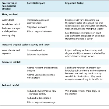
Potential impacts of climate change on the geomorphological structure of coral reefs are summarised in Table 21.2 and schematically shown in Figure 21.3. Despite earlier concerns, the consensus is now that rising sea levels alone will not present significant difficulties for healthy reefs, as projected rises are within the range of natural variability and geological precedent. Projected rates of sea level rise are well below published rates of coral growth, which are commonly around 10 to 12 mm per year for massive corals and as high as 180 mm per year for branching species22. However, coral and reef
growth rates are not synonymous. Reef accretion – the rate at which the reef grows vertically – is not only a product of coral calcification, but is also affected by factors including sediment production by other reef organisms (eg foraminiferans, molluscs, etc), bioerosion, and sediment redistribution84.
Spencer144 calculated average rates of vertical accretion for the northern, central and southern GBR
at 14, 10, and 12 mm per year respectively, again suggesting that projected sea level rise will not be problematic for healthy reefs.
Many reefs on the GBR reached sea level in the mid-Holocene82, after which continued vertical and
luxuriant reef growth was ‘turned off’ by stresses associated with a lack of accommodation space14.
Hopley77 argued that where coral growth rates have not been diminished by human activities, the
more rapid projections of future sea level rise (0.5 metres by 2100) may reinvigorate or ‘turn on’14 at
least some of these reefs by providing new accommodation space into which they may grow. Kinsey and Hopley90 estimated that the current calcification rate of about 50 million tonnes per year on
Part III: Habitats Chapter 21: V ulnerability of geomorphological features in the Great Barrier Reef to climate change
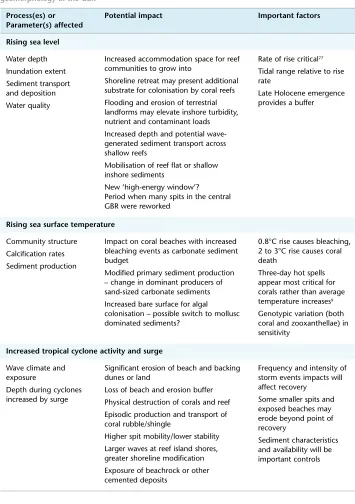
Table 21.2 Potential impacts of global climate change on coral reef geomorphological features of the GBR
Process(es) or
Parameter(s) affected Potential impact Important factors
Rising sea level
Water depth Inundation extent Sediment transport and deposition Substrate availability Water quality
Lower irradiance for deeper corals and possibly slower growth or even ‘drowning’ Increase accommodation space into which depth-constrained reef communities may extend
Shoreline retreat may present additional habitable substrate
Flooding and erosion of terrestrial landforms may elevate inshore turbidity, nutrient and contaminant loads
Greater depths and openness on the inner GBR may improve flushing and water quality in some areas
Increased depth and potential for wave-generated sediment transport across shallow reefs
Rate of rise critical77
Tidal range relative to rise rate Late Holocene sea level history important Turbidity impacts
Rising sea surface temperature
Community structure Photosynthesis/ Autotrophic activities Calcification rates and contributing calcifiers Primary production Erosion (including bioerosion) and disease Reef strength
Increased coral bleaching and loss of sensitive species
Coral reef calcification rate and sediment budget modified (composition, texture, amount, and durability of sediments) Reef growth rate may change
– construction may shift more to detrital than framework growth
Balance between primary calcification production and secondary sediment yield may be modified
Increased bare substratum for colonisation by algae and accessible to disease and bioeroders
Physical strength of coral reef structures reduced, and stability as substratum for colonisation possibly altered
0.8°C rise causes bleaching, 2 to 3°C rise causes coral death Three-day hot spells are most critical for corals, not average temperature increases9
Process(es) or Parameter(s) affected
Potential impact Important factors
Increased tropical cyclone activity and surge Wave climate and
exposure
Greater exposure to larger waves Physical destruction of corals and other living benthos
Shifts toward more storm tolerant taxa and modification of sediment types and rates of production
Increased erosion and secondary sediment production
Episodic production and transport of coral rubble/shingle
Reduced structural complexity, strength and possibly long-term wave resistance
Existing exposure to high energy storms and associated geomorphological characteristics
Tide range and reef depth relative to wave base Skeletons weakened by bioerosion, crystal poisoning, etc, more vulnerable
Enhanced rainfall Fluvial and groundwater inputs into GBR lagoon Runoff quality Inshore water quality Salinity
Coral reef growth
Increased number, duration and extent of flood plumes
Reefs further offshore affected more often by flood plumes
Increased delivery of sediments, nutrients and contaminants by flood plumes Increased benthic algae and reduced coral cover
Increased probability of low salinity mortality events in enclosed lagoons, moats and settings with restricted circulation and mixing
Increased bioerosion
Proximity to mainland and/or larger high islands
Catchment size and land use
Reduced rainfall Inshore and surface water salinity Inshore water quality
Reduced number, duration and extent of flood plumes
Offshore water conditions occur closer to the coast, possibly causing shifts in community composition and change to fewer heterotrophs
Reduced delivery of sediments, nutrients and contaminants by flood plumes Increased coral cover
Reduced bioerosion
Proximity to mainland and/or larger high islands
Catchment size and land use
Ocean acidification Calcium carbonate production and fixing
Part
III:
Habitats
Chapter
21:
V
ulnerability
of
geomorphological
features
in
the
Great
Barrier
Reef
to
climate
[image:21.499.71.423.119.410.2]change
Figure 21.3 Key processes and potential impacts of predicted climate changes on coral reefs, reef islands and high islands
Rapid rates of sea level rise will improve transmission of wave and current energy over reef surfaces, producing several effects. Depth is a critical control of energy available for sediment transport, which is likely to increase over reef flats as sea level rises. The inner part of the wide reef flat at Warraber in the Torres Strait is now around one metre above the live reef as a result of regional hydro-isostatic adjustment171, similar to many reef flats inside the zero isobase on the GBR71,115. Recent work by Kench
and Brander87 showed that the reef flat at Warraber is geomorphologically inert for most of the time
21.4.1.2 Rising sea surface temperature
Projected sea level rise may have some positive outcomes for reefs, but it is increasingly unlikely that they will outweigh the negative impacts of other climate change stressors. Rising temperatures are predicted to cause more widespread, severe, and frequent bleaching (Hoegh-Guldberg et al. chapter 10), resulting in reduced live coral cover and structural complexity, and modified reef sediment budgets. Branching
Acropora corals are likely to be affected first and gradually decline, but massive corals will be increasingly affected as SSTs continue to warm (Hoegh-Guldberg et al. chapter 10). Diminished coral cover and fecundity of survivors will reduce recovery of bleached communities, producing an increasingly bare substratum dominated by fleshy algae34. The general decline in Acropora and other primary framework
builders will reduce primary reef framework construction; fewer living Acropora and reduced shingle sediment production will be amongst the most rapid changes. However, the dynamics are complex; it has been argued that warmer sea surface temperatures will (up to a limit) produce faster growth but lower calcification107,108,93, so that material produced is more fragile and easily broken down139. More
shingle will initially be produced as declining thickets are disturbed more often, leading to at least a short period of accelerated reef evolution as lagoons are infilled by detrital sediments, however diminished recovery and thicket growth will ultimately reduce the production of this material.
Some reefs may shift toward an erosional regime, with unstable frameworks and reduced structural integrity, but again such effects are likely to be variable. Well-preserved reef surfaces and even corals formed thousands of years ago (eg fossil microatolls) suggest that this may be a very slow process and not a major problem in many areas. Conversely, however, fringing reefs in the Seychelles are now far less efficient dissipaters of wave energy than they were prior to the 1998 bleaching event and subsequent coral mortality and disintegration139.
21.4.1.3 Increased cyclone activity
Increased cyclone activity will have variable effects, with negligible impact on reefs or reef habitats in high-energy settings, but potentially large impacts on those not adapted to such events. Reefs composed of unbound detrital material, as is common for many inshore reefs142, are vulnerable
to stripping and possibly structural collapse. As for other climate stressors, the negative effects of community composition changes will be reinforced by slow and increasingly limited recovery between events. Resultant morphological changes are likely to mirror those associated with rising SSTs, with initial loss of fragile components. This loss may be hastened by skeletal weakening associated with eutrophication and crystal poisoning (where contaminants are incorporated into the skeletal structure and reduce skeletal strength130). Greater bioerosion associated with increased
benthic algae and plankton may also increase the rate of coral loss. The diminution of coarse primary carbonates to sands may be accelerated by these processes, but not enough is known to confidently predict this outcome.
Although corals are important components on most healthy reefs, other organisms are also significant contributors to reef construction (section 21.2). As coral vigour is reduced by climate change stress, other contributors, for example, molluscs, foraminiferans or coralline algae may compensate if suitable substrates and conditions are available. Halimeda, for example, has formed large banks in
areas of the GBR affected by nutrient rich upwellings41, and may become a more widespread and
Part
III:
Habitats
Chapter
21:
V
ulnerability
of
geomorphological
features
in
the
Great
Barrier
Reef
to
climate
change
by rising seas after the last ice age were linked to flourishing Halimeda by Hopley76, and are a useful
analogy for possible future changes. Carbonate sediments produced by different organisms vary markedly in important properties like durability and hydrodynamic behaviour, and shifts in producers can alter sediment transport and depositional dynamics. The impacts of such changes on various reef environments are poorly understood.
21.4.1.4 Enhanced rainfall
Increased exposure to low salinity flood plumes fed by enhanced rainfall may cause greater mortality than occurs at present, but the most significant impacts of a changed hydrological regime will probably be associated with increased nutrient and contaminant loads rather than freshwater runoff
per se. Modern reef growth occurred as the coastal plain was actively prograding (eg Belperio7,
Graham56), suggesting that floods themselves are unlikely to limit reef growth.
21.4.1.5 Ocean acidification
Increased ocean acidification will pose a critical threat to continued reef development as calcifying organisms, particularly those secreting aragonite, struggle to form skeletons131. Kleypas et al.91
suggested that doubling pre-industrial CO2 by 2050 would lower the ocean’s aragonite saturation state by 10 to 30 percent, with dire consequences for reef construction. How these changes will affect existing reefs is uncertain. Existing reefs will remain as geological structures, but the probability of continued vigorous reef growth seems low. Ecological and aesthetic reef values will also likely be diminished as detrital sediments increasingly dominate.
21.4.2 Reef islands
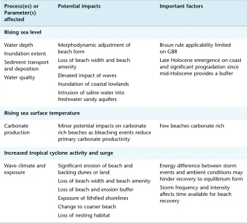
The potential impacts of climate change on reef islands of the GBR will, like the islands themselves, be diverse. Anticipated potential impacts are summarised in Table 21.3 and schematically presented in Figure 21.3.
21.4.2.1 Sea level rise
Early concerns that sea level rise will simply drown reef islands have been shown to be incorrect, with island response being the result of the complex interplay of a variety of physical, biological and chemical factors. Changes in sediment production and delivery must be considered, and the possibility that some islands will actually expand, at least in the short to medium term, is now widely accepted106,75,77,88.
Rising sea level may improve sediment transport across reef platforms by allowing larger waves to propagate further through more of each tidal cycle (section 21.4.1.1). Inner shelf reefs experienced a relative sea level fall of about a metre during the late-Holocene, allowing sediments to build up over reef flats that are immobile except during storms. Shallow depths over these reef platforms limit sediment transport and delivery to reef islands77,87, and rising sea levels might ameliorate
this impediment by allowing more wave energy across the reef platform. Hopley75 suggested that