83
Post-Processed Precise Point Positioning:
A Viable Alternative?
Thomas Grinter
Survey Infrastructure and Geodesy, Land and Property Information NSW Department of Finance & Services
Volker Janssen
Survey Infrastructure and Geodesy, Land and Property Information NSW Department of Finance & Services
ABSTRACT
The concept of Precise Point Positioning (PPP) using Global Navigation Satellite System (GNSS) technology was first introduced in 1976. However, it took until the 1990s for PPP to generate interest amongst the greater GNSS community. Over the last two decades, dual-frequency PPP has been extensively researched, and several PPP online services and software packages have been developed. This research has shown that centimetre-level point positioning is achievable in post-processed static mode. However, several limitations still remain, primarily the long convergence times needed to resolve ambiguities, currently restricting the use of PPP for high-accuracy survey applications. With the advent of cost-effective and accurate post-processing PPP services provided by organisations such as the National Aeronautics and Space Administration (NASA) Jet Propulsion Laboratory (JPL), the International GNSS Service (IGS) and Natural Resources Canada (NRCan), PPP now offers centimetre-level point positioning from much smaller observation datasets. This study compares PPP results from 1-hour, 2-hour, 4-hour, 12-hour and 24-hour observation datasets using NRCan’s PPP online service against the official, Regulation 13-certified coordinates of twenty CORSnet-NSW sites across New South Wales. It is shown that post-processed PPP can provide a viable alternative to differential techniques for survey accuracy, static survey applications for observation spans of at least 4 hours.
KEYWORDS:Precise Point Positioning, GNSS, post processing, static, CORSnet-NSW.
1 INTRODUCTION
84
accuracy, with the highest operational accuracy being possible (at the few centimetre-level) using the most sophisticated receiver equipment and algorithms, even in real-time and with the user equipment in motion.
Precise Point Positioning (PPP) is an alternative positioning method that employs widely and readily available GNSS orbit and clock correction products, e.g. obtained via the International GNSS Service (IGS), to perform point positioning using a single GNSS receiver (Kouba, 2009). This provides PPP with an advantage over differential techniques in that only a single receiver is necessary (at the user’s end), removing the need for the user to establish a local base station or access data from surrounding Continuously Operating Reference Station (CORS) networks. Consequently, the spatial operating range limit of differential techniques is negated, as well as the need for simultaneous observations at both rover and reference station. This, in turn, can reduce labour and equipment costs and simplify operational logistics (Gao, 2006). It should be noted, however, that an international CORS network is required to calculate the GNSS orbit and clock correction products essential for PPP. Since this international CORS network is so far removed and hidden from the user, PPP is assumed to provide stand-alone point positioning.
The use of a single GNSS receiver for PPP also invokes major disadvantages. The most significant disadvantage is the long convergence time necessary (> 20 minutes) for the float solution to converge to centimetre accuracy, thus limiting its use in real-time applications. PPP requires a number of corrections to limit the effects of centimetre-level variations to un-differenced code and phase observations. Phase wind-up corrections, satellite antenna phase centre corrections, solid earth tide corrections and ocean loading corrections are all necessary for accurate PPP solutions, but not considered for standard differential positioning techniques (i.e. short/medium-length static baselines, kinematic and real-time techniques). For a review of recent developments in PPP, the reader is referred to Grinter and Roberts (2011).
At present, post-processed PPP offers the most comparable accuracies to differential positioning techniques. PPP post-processing services such as Auto-GIPSY from the National Aeronautics and Space Administration (NASA) Jet Propulsion Laboratory (JPL) (JPL, 2012) and Natural Resources Canada’s (NRCan’s) CSRS-PPP (NRCan, 2010) provide converged float solutions at the centimetre-level. This has allowed PPP to offer a viable alternative to post-processed differential GNSS solutions for some applications.
CSRS-PPP provides converged GPS & GLONASS float solutions utilising IGS satellite orbits and clock corrections, satellite/receiver antenna phase offsets, tropospheric models including hydrostatic and wet delay and mapping functions. It should be noted that it also allows ocean loading coefficients to be input by the user. However, this was deemed unnecessary in this study because the average user will generally not have access to these coefficients.
85
Furthermore, the processing time and skills needed to process conventional GNSS baselines (even via commercial off-the-shelf software) is greater compared to post-processed PPP, which involves sending the observed data to a third party for position determination. It was concluded that PPP yields a “slightly lower accuracy” but is a more cost-effective alternative to establishing geodetic control, particularly applicable in remote areas or developing countries. Ebner and Featherstone (2008) also noted that at least two continuous days of observations were required to achieve reliable results, in this case interpreted as a PPP solution within 20 mm of the Bernese solution.
This paper employs NRCan’s CSRS-PPP online service (NRCan, 2010) to investigate what accuracies can be expected when using a PPP-only approach to geodetic control at twenty CORS sites across NSW, based on observation periods of different lengths (between 1 and 24 hours). The accuracy is determined by comparison to the official coordinates of these CORS, which were obtained from a differential GPS network solution performed by Geoscience Australia during the Regulation 13 process (see section 2). It is shown that survey accurate PPP solutions (here defined as 25 mm in Easting and Northing, and 35 mm in Ellipsoidal Height) can be obtained for observation windows of at least 4 hours.
2 STUDY AREA: CORSnet-NSW
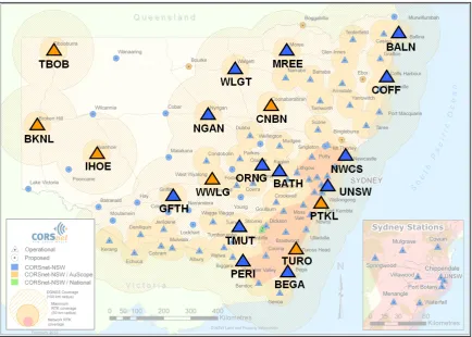
CORSnet-NSW is a rapidly growing network of GNSS CORS providing fundamental positioning infrastructure for New South Wales that is accurate, reliable and easy to use (Janssen et al., 2011; LPI, 2012). The network also provides stimulus for innovative spatial applications and research using satellite positioning technology. It is built, owned and operated by Land and Property Information (LPI), a division of the NSW Department of Finance & Services. CORSnet-NSW currently (February 2012) consists of more than 80 CORS tracking multiple satellite constellations, and efforts are underway to expand the network to over 120 stations by the end of 2013.
In order to distinguish GNSS CORS networks in regards to their purpose, the concept of a tiered hierarchy of permanent GNSS reference stations was proposed by Rizos (2007) and has since been widely accepted across Australia (Burns and Sarib, 2010). Tier 1 stations contribute to international or global geodesy initiatives, Tier 2 stations provide primary national geodetic infrastructure for datum definition, and Tier 3 stations are secondary state or private GNSS networks, often established for real-time precise positioning services. While Tier 1 and Tier 2 sites generally require solid pillar monuments firmly anchored to bedrock, Tier 3 sites are often mounted on buildings. This original hierarchy has been adopted and expanded by CORSnet-NSW (LPI, 2011).
Initially, seven Tier 2 CORSnet-NSW sites were selected for this study, as these provide the most stable CORS sites with the clearest skyview and the most advanced GNSS antennas. A further 13 Tier 3 sites were added to increase the size of the dataset and provide a more even distribution across NSW. Extensive and continuous scientific processing by LPI and Geoscience Australia has proven the long-term stability of Tier 3 sites (data not shown).
86
Figure 1: CORSnet-NSW coverage map (current at February 2012), including the 20 CORS sites investigated. Tier 2 sites are shown in orange, Tier 3 sites in blue.
The Geocentric Datum of Australia (GDA94) is the basis for geodetic infrastructure in Australia (ICSM, 2006). For a review of coordinate systems, datums and associated transformations the reader is referred to Janssen (2009). All CORSnet-NSW sites are coordinated via Regulation 13 certification, which provides coordinates in the GDA94(2010) realisation of the national datum (Janssen and McElroy, 2010). The so-called ‘Reg 13’ certificates are issued by Geoscience Australia, a facility accredited by the National Association of Testing Authorities (NATA). Geoscience Australia determines 3-dimensional site coordinates, which are stated on these certificates, based on a differential GPS network solution using one complete week of 30-second GPS data (in RINEX format) and highly traceable, standardised, scientific processing using the Bernese 5.0 software (Dach et al., 2007). These certificates are valid for five years (assuming that no equipment change occurs) and provide a Recognised Value Standard for positioning infrastructure with respect to the national datum. Through this facility the site coordinates are linked to a standard of measurement in accordance with the National Measurement Regulations 1999 and the National Measurement Act 1960.
87
coordinates to better than 10 mm in horizontal position and 15 mm in ellipsoidal height (data not shown).
3 TESTING METHODOLOGY AND DATA USED
The PPP solutions investigated in this study were obtained by NRCan’s CSRS-PPP online processing service (NRCan, 2010). It is important to note that CSRS-PPP results are referred to the International Terrestrial Reference Frame (ITRF, see Altamimi et al., 2011) and not GDA94. In order to enable coordinate comparisons to the official CORSnet-NSW coordinates (determined via Regulation 13 certification), the ITRF2005 or ITRF2008 precise position estimates had to be transformed to GDA94. It should be noted that this extra step in the process can lead to the propagation of further errors in the final coordinates (Haasdyk and Janssen, 2011, 2012a). Following GNSS best practice, a 14-parameter similarity transformation between ITRF and GDA94 was applied utilising the parameters stated in Dawson and Woods (2010).
For each of the twenty CORSnet-NSW sites investigated, a subset of the 7-day GNSS dataset used to determine the Regulation 13 certified coordinates was utilised, i.e. day four (middle day). In the case of CNBN, a 24-hour AUSPOS solution was used instead. Each 24-hour file was then divided into separate 1-hour, 2-hour, 4-hour and 12-hour files centred on 12:00 UT. This ensured that all PPP coordinate solutions obtained at a site referred to the same ITRF epoch (i.e. 12:00 UT on the selected day), as well as referring to the same epoch used for Regulation 13 certification. These files were then submitted to the CSRS-PPP service for processing.
The resulting PPP coordinates, obtained from observation windows of varying length, were then transformed to GDA94 and compared against their official Regulation 13 values. An initial analysis was based on the seven Tier 2 CORSnet-NSW sites currently in operation. This sample was then extended by a further 13 Tier 3 sites to provide a more even distribution across NSW.
4 RESULTS AND DISCUSSION
4.1 Post-Processed PPP Performance for Longer Observation Windows
It is recognised that a longer observation window generally provides a better coordinate solution for static GNSS applications, simply because more data can be used in processing. In practice, the observation window chosen is usually a compromise between the requirement to collect enough data to meet accuracy specifications on one hand and the logistics and cost of the fieldwork on the other. In an initial analysis, it was investigated how well the 12-hour and 24-hour PPP solutions agree with the official Regulation 13 values (here assumed to be the ‘true’ coordinates). The aim was to determine whether there is a significant difference in coordinate quality between these two solutions. This analysis was limited to the seven Tier 2 sites currently operating in CORSnet-NSW (see Figure 1).
88
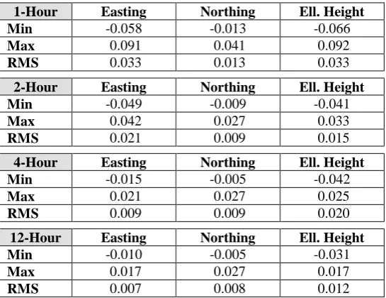
[image:6.595.162.435.545.755.2]can be interpreted as the average accuracy at the 1-sigma level. While there is a slight improvement (a few millimetres) in positioning quality when using 24 hours of data, this improvement is generally negligible for static positioning at the 2-centimetre level required for most survey practice. Based on these findings, the remaining analysis was limited to observation windows up to 12 hours.
Table 1: CSRS-PPP vs. Regulation 13 coordinate comparison across seven Tier 2 sites for 12-hour and 24-hour observation windows. All values in metres.
12-Hour Easting Northing Ell. Height
Min -0.010 -0.005 -0.031
Max 0.013 0.012 0.008
RMS 0.007 0.008 0.014
24-Hour Easting Northing Ell. Height
Min -0.007 -0.005 -0.030
Max 0.008 0.009 0.006
RMS 0.005 0.006 0.012
4.2 Post-Processed PPP Performance for Shorter Observation Windows
In practice, the GNSS observation window is selected to be as short as possible but long enough to provide a reliable position that meets accuracy requirements. In order to investigate how long it takes for the CSRS-PPP solutions to converge to an acceptable level, PPP solutions were obtained for 1-hour, 2-hour, 4-hour and 12-hour files centred around 12:00 UT, and compared to their official Regulation 13 values (or, for CNBN, the 24-hour AUSPOS solution). This analysis was performed for all Tier 2 and Tier 3 sites investigated (i.e. 20 CORS in total) to provide an even distribution across NSW.
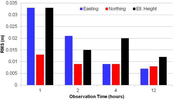
For each observation window length, Table 2 lists the minimum and maximum differences from the official Regulation 13 coordinates across all sites, as well as the RMS. Figure 2 graphically illustrates the RMS values obtained for each coordinate component to allow easy, visual comparison.
Table 2: CSRS-PPP vs. Regulation 13 coordinate comparison across 20 sites for 1-hour, 2-hour, 4-hour and 12-hour observation windows. All values in metres.
1-Hour Easting Northing Ell. Height
Min -0.058 -0.013 -0.066
Max 0.091 0.041 0.092
RMS 0.033 0.013 0.033
2-Hour Easting Northing Ell. Height
Min -0.049 -0.009 -0.041
Max 0.042 0.027 0.033
RMS 0.021 0.009 0.015
4-Hour Easting Northing Ell. Height
Min -0.015 -0.005 -0.042
Max 0.021 0.027 0.025
RMS 0.009 0.009 0.020
12-Hour Easting Northing Ell. Height
Min -0.010 -0.005 -0.031
Max 0.017 0.027 0.017
89
Figure 2: Average agreement of CSRS-PPP solutions to Regulation 13 across 20 sites for different observation windows.
From Table 2 and Figure 2 it can be seen that, as expected, PPP solutions based on shorter observation windows (i.e. 1 and 2 hours) produce larger differences to the official coordinates than those based on longer observation windows (i.e. 4 and 12 hours). This is apparent for both the RMS (i.e. the average agreement) and the minimum/maximum values (i.e. the largest disagreement across the twenty sites). In regards to the RMS, this behaviour is particularly evident in the Easting coordinates, with coordinate differences converging for the longer observation spans. It should be noted that the overall height quality of the 2-hour PPP solutions was better than expected, in this case outperforming agreement in the Easting component.
The improvement between the 4-hour and the 12-hour solutions is only minor, both in terms of RMS and the minimum/maximum values. This shows that a 4-hour dataset can generally provide very similar results to the much longer 12-hour dataset, assuming typical survey requirements.
An outlier in the 1-hour PPP solution for ORNG accounts for the second largest difference in the Easting (-58 mm), and the largest difference in the Northing (41 mm) and Ellipsoidal Height (92 mm) components across all sites. This site is known to exhibit less than favourable multipath conditions. Removing ORNG from the 1-hour analysis reduced the RMS values from 33, 13 and 33 mm to 30, 10 and 26 mm in Easting, Northing and Ellipsoidal Height respectively. The PPP solution for ORNG improved significantly when using two hours of data, showing much better agreement to the Regulation 13 coordinates (-4 mm, 27 mm and 22 mm in Easting, Northing and Ellipsoidal Height).
WLGT is another example of a site that is more prone to multipath than usual. Since the effect of multipath can generally be cancelled out (at least to some degree) over time, the agreement to the Regulation 13 coordinates improves considerably with increasing observation length (Table 3).
90
Table 3: CSRS-PPP vs. Regulation 13 coordinate comparison at WLGT for 1-hour, 2-hour, 4-hour and 12-hour observation windows. All values in metres.
Easting Northing Ell. Height 1-Hour 0.091 0.002 0.044 2-Hour 0.042 0.003 0.033 4-Hour 0.018 0.000 0.025
12-Hour -0.001 0.003 -0.002
These examples show the effect that larger-than-normal differences from the ‘true’ Regulation 13 coordinates can have on the average agreement determined from the relatively limited sample size of twenty CORS investigated in this study. It is well known that shorter observation windows are more likely to be affected by multipath than longer observation spans.
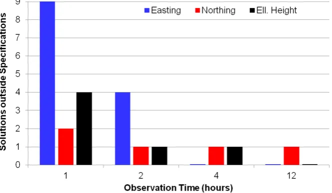
[image:8.595.133.466.440.634.2]Let us assume typical survey requirements of obtaining accuracies at the 25 mm level for Easting and Northing, and 35 mm in Ellipsoidal Height. Out of the twenty 1-hour PPP solutions investigated, 11 fell outside these specifications in at least one coordinate component (i.e. 55% failed). Using a 2-hour observation window improved the results, but still left 6 (30%) solutions outside specifications. The 4-hour dataset only showed 2 (10%) solutions that did not meet specifications. All 12-hour solutions met specifications, with the small exception of one solution in Northing slightly outside specifications (i.e. 27 mm).
Figure 3 illustrates these findings visually. It should be noted that ORNG contributes heavily to the instances outside specifications in all datasets, i.e. in Easting, Northing and Ellipsoidal Height (1-hour dataset), as well as Northing (2-hour, 4-hour and 12-hour datasets).
Figure 3: Number of PPP coordinate component solutions outside specifications (25 mm in Easting/Northing and 35 mm in Ellipsoidal Height) across 20 sites, for different observation windows.
91
This result provides a significant improvement on findings reported by Ebner and Featherstone (2008) who noted that at least two continuous days of observations were required to achieve results within 20 mm of a Bernese network solution. While it is recognised that the focus of the present study is different from the Ebner and Featherstone (2008) study, and is based on a small sample size, it is clear that PPP has evolved significantly over the last five years or so. Post-processed PPP can provide a viable alternative to differential GNSS processing for static applications, even with observation spans as short as 4 hours, provided that the vital step of transforming between ITRF and GDA94(2010) is performed using GNSS best practice (Haasdyk and Janssen, 2011, 2012a). If a connection to the local survey control network in NSW is required, a site transformation must be performed (Haasdyk and Janssen, 2012b). However, it should be remembered that differential GNSS positioning will continue to provide superior results (accuracy and reliability), simply due to the processing strategy employed. PPP is evolving, and its potential and developments should be closely monitored. It is up to the spatial professional to decide which tool is the most suitable for a given job.
5 CONCLUDING REMARKS
Cost-effective and accurate online post-processing PPP services are now able to offer centimetre-level point positioning for static applications in Australia, provided the resulting positions (generally given in a global datum such as ITRF2008) are transformed to GDA94. If a connection to the local survey control network in NSW is required, a site transformation must be performed.
This study has compared PPP results from 1-hour, 2-hour, 4-hour, 12-hour and 24-hour observation datasets using the CSRS-PPP online service against the official, Regulation 13-certified coordinates of twenty CORSnet-NSW sites across the state. It was shown that post-processed PPP can provide a viable alternative to differential GNSS techniques for survey-accuracy, static applications using observation spans of 4 hours. The risk of outliers can be minimised by utilising a longer observation window, while excessive 12-24 hour occupations do not appear to provide any further improvements in meeting the specifications assumed in this study (within 25 mm in Easting/Northing and 35 mm in Ellipsoidal Height). However, it should be emphasised that outliers can always occur, so double occupations are strongly recommended (and continue to be GNSS best practice). Post-processed PPP can be potentially useful in regional areas that are currently not covered by a sufficiently dense CORS infrastructure.
REFERENCES
Altamimi Z., Collilieux X. and Métivier L. (2011) ITRF2008: An improved solution of the
international terrestrial reference frame, Journal of Geodesy, 85(8), 457-473.
Burns D. and Sarib R. (2010) Standards and practices for GNSS CORS infrastructure,
networks, techniques and applications, Proceedings of XXIV FIG International Congress
2010, 11-16 April, Sydney, Australia, 16pp.
92
Dawson J. and Woods A. (2010) ITRF to GDA94 coordinate transformations, Journal of
Applied Geodesy, 4(4), 189-199.
Ebner R. and Featherstone W.E. (2008) How well can online GPS PPP post-processing
services be used to establish geodetic survey control networks? Journal of Applied
Geodesy, 2(3), 149-157.
GA (2011) AUSPOS – Online GPS processing service,
http://www.ga.gov.au/earth-monitoring/geodesy/auspos-online-gps-processing-service.html (accessed Feb 2012).
Gao Y. (2006) Precise Point Positioning and its challenges, Inside GNSS, 1(8), 16-18.
Grinter T. and Roberts C. (2011) Precise Point Positioning: Where are we now? Proceedings
of International GNSS Society Symposium (IGNSS2011), Sydney, Australia, 15-17 November, 15pp.
Haasdyk J. and Janssen V. (2011) The many paths to a common ground: A comparison of
transformations between GDA94 and ITRF, Proceedings of International GNSS Society
Symposium (IGNSS2011), Sydney, Australia, 15-17 November, 16pp.
Haasdyk J. and Janssen V. (2012a) Choosing the best path: Global to national coordinate
transformations, Coordinates, 8(2), 10-16.
Haasdyk J. and Janssen V. (2012b) Site transformations: A block shift in thinking,
Proceedings of Association of Public Authority Surveyors Conference (APAS2012), Wollongong, Australia, 19-21 March, 29-47.
ICSM (2006) Geocentric Datum of Australia technical manual, version 2.3,
http://www.icsm.gov.au/icsm/gda/gdatm/index.html (accessed Feb 2012).
Janssen V. (2009) Understanding coordinate reference systems, datums and transformations,
International Journal of Geoinformatics, 5(4), 41-53.
Janssen V., Haasdyk J., McElroy S. and Kinlyside D. (2011) CORSnet-NSW: Improving
positioning infrastructure for New South Wales, Proceedings of Surveying & Spatial
Sciences Institute Biennial International Conference (SSSC2011), Wellington, New Zealand, 21-25 November, 395-409.
Janssen V. and McElroy S. (2010) Coordinates and CORSnet-NSW: Dealing with distortions
in GDA94, Position, 50, 24-27.
JPL (2012) The automatic precise positioning service of the Global Differential GPS
(GDGPS) System, http://apps.gdgps.net/ (accessed Feb 2012).
Kouba J. (2009) A Guide to using International GNSS Service (IGS) products, Natural
Resources Canada, http://igscb.jpl.nasa.gov/components/usage.html (accessed Feb 2012).
LPI (2011) Guidelines for CORSnet-NSW Continuously Operating Reference Stations
(CORS), version 1.0, available from
http://www.lpi.nsw.gov.au/surveying/corsnet-nsw/education_and_research (accessed Feb 2012).
LPI (2012) CORSnet-NSW, http://www.corsnet.com.au/ (accessed Feb 2012).
NRCan (2010) Online global GPS processing service (CSRS-PPP),
http://www.geod.nrcan.gc.ca/products-produits/ppp_e.php (accessed Feb 2012).
Rizos C. (2007) Alternatives to current GPS-RTK services & some implications for CORS