Processing Laser Scanner Plant Data To Extract Structural Information
Jim Hanan, Birgit Loch, Tim McAleer Advanced Computational Modelling Centre
Department of Mathematics University of Queensland, Australia
[jim,bil]@maths.uq.edu.au
Plant architecture information has traditionally used the hierarchical structure of the plant as its basis, with digitised point data from real plants entered in a particular hierarchical pattern. Data collection and classification have thus been inseparable. The advent of laser profile scanners, such as the Polhemus FastSCAN, means that 3D plant data can be captured holistically. The data acquired from laser surface scanners is in unordered point cloud form, with points collected only on the surface of the object under study.
This means that the structure of the plant must be extracted from the cloud of 3D co-ordinates using manual methods. This paper describes issues arising when using a Polhemus FastSCAN laser scanner, and a program for manual extraction of points developed at the Advanced Computational Modelling Centre (ACMC), which can be used independently or with specialised software such as FloraDig [1].
The Laser Scanner
The FastSCAN handheld laser scanner [2,3] is an elegant combination of an optical and an electromagnetic device (Figure 1). A magnetic field is generated by which the position of the “wand” is determined at any time. Pressing the trigger causes a scan line of red laser light to be emitted. When the scan line is swept over the object, intersections of the laser line with the surface of the object (the profiles) are captured by video cameras mounted at an angle to the laser line generator on the wand, and processed into data points by joining sweeps. The nominal resolution for captured data is 0.5 mm, this number is influenced by the speed with which the wand is swept over the surface [4]. The number of points measured with the laser scanner can be enormous since each sweep will add a large amount of data. FastSCAN software allows the export of reduced surface data generated from the raw data as ASCII data files. As overlapping sweeps are merged, this will result in unique data points that are not clustered where overlapping occurred. The new set of points is calculated to a user-specified resolution. One of the advantages of the laser scanner is that it is a non-contact method, in other words the surface of the plant does not need to be touched by a probe. In comparison, contact devices often encounter measurement error if the object is displaced and generally lead to smaller data sets than non-contact methods since every single data point needs to be selected by the operator.
Scanning Issues
Application of the laser scanner for plant digitising raises several issues. One is that the surface may not produce sufficient laser contrast for the scanner to detect a profile. This may be caused by shininess or by the colour of a surface. Since a green surface will absorb light of any colour but green and laser light is relatively pure in colour, not enough of a red laser beam may be reflected from the object and received by the scanner cameras to calculate positions of the data points. Rather than an expensive change from a red to a green laser, the surface may be treated to change its reflective properties. Using an airbrush, very fine chalk or clay dust can be mixed with water and then sprayed onto the surface, which is subsequently left to dry. This technique has been successfully applied to leaf surfaces in [5], see Figures 1 and 2. The added thin layer allows the user to capture data on plant surfaces using a red laser scanner.
[image:2.595.192.405.266.403.2]
Figure 1: The laser scanner, from [5].
Figure 2: A treated leaf surface, from [5].
Another issue for performance of the laser scanner is magnetic interference. All metallic objects and electromagnetic fields need to be removed from within a certain distance from the transmitter, since they interfere with the magnetic field generated to identify the position and the orientation of the wand. Failure to do so will result in faulty data. We observed that even a watch worn by the scanner operator may adversely affect the quality of the resulting data.
[image:2.595.172.424.446.584.2]An additional issue for whole plant scanning is that at least one out of the two cameras needs to have a direct line of view of the profile at all times, otherwise scanning is impossible. This means that hidden plant parts cannot be scanned.
Since background information is often captured, editing of the data with a point manipulation program such as PointPicker developed at the ACMC to remove unwanted points is desirable. This type of program is also required when specific points need to be selected from large sets of data points.
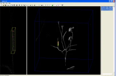
PointPicker
PointPicker is a program designed to take a cloud of point data from an ASCII source file and allow the user to select or delete individual points from a graphical display of that data. Point data can come from any source, as long as it is space delimited; valid file extensions are *.txt and *.asc. The program will typically be used to process data from the laser scanner, and it is capable of communicating the selected points to other programs, for instance FloraDig [1]. PointPicker has a text edit pane (Figure 3, on the
right), which can be used to copy and paste data into other applications, such as Excel.
The program features two 3D viewing panes (Figure 3). The right-hand pane automatically sizes its image to the complete data cloud. The left enlarges a highlighted region of the right pane. Zoom, rotate and dolly functions are available for moving the object in the view, and sections can be highlighted by marking a resizable circular or rectangular area in the viewing plane. These functions can all be accessed through the menu, the toolbar or through the right-click invoked context menu. Single 3D points can be collected from the enlarged highlighted point set in the left pane; they will then be coloured differently, and can be connected by line segments if desired. These points can be explicit points that are present in the loaded file, or calculated averages of several nearby points. Collected points appear in the edit pane, and can be directly copied to other programs.
[image:3.595.96.502.480.747.2]
Features of PointPicker include deleting single points or complete highlighted regions, as well as inverting the selection of points. This is particularly useful when background data needs to be deleted, as it only requires selection of the object that should be kept. Any changes made can be undone, this also includes un-deleting points. Two different options exist for saving data – one allows the complete set as displayed in the right 3D viewing pane to be saved, the other only saves the collected points that are listed in the edit pane.
Conclusions
The laser scanner is a useful device for digitising surface information from plants. In combination with PointPicker, it is a very powerful tool to capture large amounts of data, and reduce it to points at desired locations.
Future work in the area of scanning plant data with a laser scanner includes testing differently coloured laser scanners. For example a near infra red [6] or a green laser scanner may be able to collect data from a plant surface without treatment, although shininess may still be a problem. Polhemus have since released a new model, the FastSCAN Cobra handheld laser scanner, which is half the size of the model used here and operates with only one camera. Due to its reduced size, it may be easier to reach semi-hidden plant parts with this model.
Future features for PointPicker will include the option to assign colours to different imported point sets. Progress has already been made in the development of an automatic, voxel-based technique for segmenting the data into branches, to identify features of interest such as branching points. This will eventually allow the user to define hierarchical structures when collecting data and to reconstruct plant organs from data clouds. This approach is based on previous work on human airways through CT images [7] and automatic data segmentation [8].
Current research concentrating on leaf surface modelling is investigating automated ways of reducing the number of data points acquired with the laser scanner without extensive loss of quality of the resulting surface fit. Points chosen in this way describe significant locations on a leaf surface where data should be sampled. Knowledge of such locations can be used to give advice to operators of single-point digitising devices such as sonic digitisers [9] on where data should be collected.
Current research concentrating on leaf surface modelling is investigating ways of reducing the number of data points required without extensive loss of quality of the resulting surface fit. Large data sets acquired with the laser scanner are analysed to determine significant locations on a leaf surface where data should be sampled. Knowledge of such locations can be used to give advice to operators of single-point digitising devices such as sonic digitisers [9] on where data should be collected.
References
[1]Hanan, J. and Room, P. Floradig User Manual, Centre for Plant Architecture
[2] McCallum, B.C. and Fright, W.R. and Nixon, M.A. and Price, N.B., “A Feasibility Study of Hand-held Laser Surface Scanning”,
Proceedings, Image and Vision Computing New Zealand, Lower Hutt, August 1996, pp. 103-108, 1996
[3]McCallum, B.C. and Nixon, M.A. and Price, N.B. and Fright, W.R.,
“Hand-held Laser Scanning in Practice”, Proceedings, Image and Vision Computing NZ, The University of Auckland, October 1998,
pp. 17-22, 1998
[4] FastSCAN Cobra Handheld Laser Scanner Manual, download at http://www.polhemus.com, 2003
[5] Loch, B., “Surface Fitting for the Modelling of Plant Leaves”, submitted PhD Thesis, University of Queensland, Australia, 2004
[6] Sinoquet et al., “DALI: an automated laser distance system for measuring profiles of vegetation”, Agricultural and Forest Meteorology, 67, pp. 43-64, 1993
[7] Wood, S. A. and Hoford, J. D. and Hoffman, E.A. and Zerhouni, E and Mitzner. W.”A method for measurement of the cross sectional area, segment length, and branching angle of airway tree structures in situ”. Computerized Medical Imaging and Graphics. V 19, No. 1. pp. 145-152. 1995
[8] Huang, J. and Menq, C. H. “Automatic Data Segmentation for Geometric Feature Extraction From Unorganized 3-D Coordinate Points.” IEEE Trans on Robotics and Automation, 17 (3) June 2001
[9] Room, P. and Hanan, J. “Virtual plants: new perspectives for ecologists,
![Figure 2: A treated leaf surface, from [5].](https://thumb-us.123doks.com/thumbv2/123dok_us/341351.65782/2.595.192.405.266.403/figure-treated-leaf-surface.webp)