www.hydrol-earth-syst-sci.net/21/1455/2017/ doi:10.5194/hess-21-1455-2017
© Author(s) 2017. CC Attribution 3.0 License.
Impacts of future deforestation and climate change on the
hydrology of the Amazon Basin: a multi-model analysis
with a new set of land-cover change scenarios
Matthieu Guimberteau1, Philippe Ciais1, Agnès Ducharne2, Juan Pablo Boisier3, Ana Paula Dutra Aguiar4,
Hester Biemans5, Hannes De Deurwaerder6, David Galbraith7, Bart Kruijt5, Fanny Langerwisch8, German Poveda9, Anja Rammig8,10, Daniel Andres Rodriguez11, Graciela Tejada4, Kirsten Thonicke8, Celso Von Randow4,
Rita C. S. Von Randow4, Ke Zhang12, and Hans Verbeeck6
1Laboratoire des Sciences du Climat et de l’Environnement, LSCE/IPSL, CEA-CNRS-UVSQ, Université Paris-Saclay,
91191 Gif-sur-Yvette, France
2Sorbonne Universités, UPMC, CNRS, EPHE – UMR7619 METIS, 75252 Paris, France
3Department of Geophysics, Universidad de Chile, and Center for Climate and Resilience Research (CR2), Santiago, Chile 4Centro de Ciência do Sistema Terrestre (CCST), Instituto Nacional de Pesquisas Espaciais (INPE), Av dos Astronautas
1758, 12227-010, São José dos Campos, Brazil
5Wageningen University & Research (Alterra), Wageningen, the Netherlands
6CAVElab – Computational and Applied Vegetation Ecology, Department of Applied Ecology and Environmental Biology,
Faculty of Bioscience Engineering, Ghent University, Coupure Links 653, 9000 Ghent, Belgium
7School of Geography, University of Leeds, Leeds, UK
8Earth System Analysis, Potsdam Institute for Climate Impact Research (PIK), P.O. Box 60 12 03, Telegraphenberg A62,
14412 Potsdam, Germany
9School of Geosciences and Environment, Universidad Nacional de Colombia, Medellín, Colombia
10TUM School of Life Sciences Weihenstephan, Land Surface–Atmosphere Interactions, Technical University of Munich,
Freising, Germany
11Centro de Ciência do Sistema Terrestre (CCST), Instituto Nacional de Pesquisas Espaciais (INPE), Rodovia Presidente
Dutra km 39, CP 01, CEP: 12630-000, Cachoeira Paulista, São Paulo, Brazil
12State Key Laboratory of Hydrology–Water Resources and Hydraulic Engineering, and College of Hydrology and Water
Resources, Hohai University, 1 Xikang Road, Nanjing, China
Correspondence to:Matthieu Guimberteau (matthieu.guimberteau@lsce.ipsl.fr) Received: 22 August 2016 – Discussion started: 24 August 2016
Revised: 5 January 2017 – Accepted: 9 February 2017 – Published: 9 March 2017
Abstract.Deforestation in Amazon is expected to decrease evapotranspiration (ET) and to increase soil moisture and river discharge under prevailing energy-limited conditions. The magnitude and sign of the response of ET to defor-estation depend both on the magnitude and regional patterns of land-cover change (LCC), as well as on climate change and CO2 levels. On the one hand, elevated CO2 decreases
leaf-scale transpiration, but this effect could be offset by in-creased foliar area density. Using three regional LCC sce-narios specifically established for the Brazilian and
precipitation increases by 8.5%, with a large uncertainty across GCMs. In the case of no deforestation, we found that ET and runoff increase by 5.0 and 14 %, respectively. However, in south-east Amazonia, precipitation decreases by 10 % at the end of the dry season and the three LSMs produce a 6 % decrease of ET, which is less than precipitation, so that runoff decreases by 22%. For instance, the minimum river discharge of the Rio Tapajós is reduced by 31 % in 2100. To study the additional effect of deforestation, we prescribed to the LSMs three contrasted LCC scenarios, with a forest decline going from 7 to 34 % over this century. All three scenarios partly offset the climate-induced increase of ET, and runoff increases over the entire Amazon. In the south-east, however, deforestation amplifies the decrease of ET at the end of dry season, leading to a large increase of runoff (up to+27 % in the extreme deforestation case), offsetting the negative effect of climate change, thus balancing the de-crease of low flows in the Rio Tapajós. These projections are associated with large uncertainties, which we attribute sepa-rately to the differences in LSMs, GCMs and to the uncer-tain range of deforestation. At the subcatchment scale, the uncertainty range on ET changes is shown to first depend on GCMs, while the uncertainty of runoff projections is pre-dominantly induced by LSM structural differences. By con-trast, we found that the uncertainty in both ET and runoff changes attributable to uncertain future deforestation is low.
1 Introduction
The Amazon Basin provides a range of ecosystem services. The rivers are used for navigation and hydropower; the for-est is an important global sink and store of carbon, and a store of biodiversity; evaporation provides a water vapour source for rainfall downwind. When analysing changes to this ecosystem, it is important to take an integrated approach because each of these services may be affected by, or may affect, the others. Currently, two major changes are taking place simultaneously in Amazonia: deforestation and climate change. From the middle 1970s, southern Amazonia has ex-perienced widespread deforestation (Moran, 1993) with for-est being cleared to create new pasture and cropland (Fearn-side, 2005). About 7.3 % of the Amazon Basin was defor-ested between 1976 and 2003 (Callède et al., 2008) and a further 2.6 % between 2000 and 2010 (Song et al., 2015). At the same time, the background level of CO2has been rising
and the climate has been changing in response (IPCC, 2013). These changes are expected to continue, to some degree, for the rest of this century.
Here, we focus on future changes to the river hydrol-ogy of the Amazon Basin. For different deforestation sce-narios, we model the changes in river flow from grid-based drainage and runoff estimated by different land surface mod-els (LSMs) driven by forcing data derived from general
cir-culation model (GCM) output. Because of the long transit times of water moving from soil to the mouth of the Ama-zon, to simulate discharge requires LSMs to be coupled to a river routing scheme (Biemans et al., 2009; Guimberteau et al., 2012; Langerwisch et al., 2013).
The climate of the Amazon Basin is notoriously difficult to model and there is a wide between-GCM variation in the estimated precipitation and its changes (Boisier et al., 2015). This introduces a first level of uncertainty.
Equally, several LSMs exist and, to a greater or lesser ex-tent, they all incorporate existing process knowledge into their parameterizations (Gash et al., 2004; Keller et al., 2009). However, because of their different structures and the values of the parameters used, LSMs also simulate a range of changes in the water and energy balances even when forced by the same input climate data. The differences between models’ results relate in a complex way to simulated vege-tation structure, phenology and physiology as well as to soil hydrological processes. This introduces a second level of un-certainty.
ar-Figure 1.Panel(a)indicates Amazon catchments (names in white; the abbreviations are indicated in Table S1) and the main rivers (adapted from Guimberteau et al., 2012), with localization of the main SO HYBAM gauging stations (the abbreviations are indicated in Table S1). The bold black line delineates the Madeira catchment. Colour is used to distinguish the southern (red), western (purple) and northern catchments (pink). Panel(b)indicates the percentage of deforestation in each 25×25 km2in 2005 (observed data; Aguiar et al., 2016).
eas (Dalla-Nora et al., 2014). At the same time, the future of the region remains highly uncertain, as several factors may contribute to the return of high deforestation rates, in-cluding the rapidly expanding global markets for agricultural commodities, large-scale transportation and energy infras-tructure projects and weak institutions (Aguiar et al., 2016). In this complex context, in order to better represent the cur-rent situation of the region, we adopted the updated and con-trasting scenarios generated in the scope of the AMAZA-LERT project (raising the alert about critical feedbacks be-tween climate and long-term land use change in the Amazon, http://www.eu-amazalert.org/home) for this study.
Here, we apply for the first time three grid-based LSMs forced by three different GCM climate projections and more realistic regional LCC scenarios, combining the effect of un-certainty in GCM forcing data, LSM structure and LCC fu-ture scenarios, and allowing us to estimate the magnitude of likely future hydrological changes due to deforestation and climate change and their uncertainty. In particular, we discuss the relative contribution of GCM uncertainty, LSM uncertainty and LCC scenario uncertainties in future pro-jections of runoff and evapotranspiration (ET) fluxes, with a special focus on the more vulnerable southern Amazon catchments.
2 Materials and methods
2.1 Simulation design and models
The time frame studied includes a present period represent-ing current climate conditions (1970–2008) and 21st
cen-tury projections (2009–2100). Although the domain used in the simulations described below includes the whole Ama-zon Basin (Fig. 1a and Table S1 in the Supplement), the analysis focuses on the catchments sensitive to deforesta-tion (Fig. 1b). We selected the southern catchments, which are subjected to a distinct dry season today, and are both sensitive to future precipitation changes (Guimberteau et al., 2013; Boisier et al., 2015) and vulnerable to future deforesta-tion (Coe et al., 2009; Costa and Pires, 2010). These catch-ments are the Rio Madeira (MAD) and its upstream tributary, the Mamoré (MAM), and the two large south-eastern catch-ments of the Tapajós (TAP) and Xingu (XIN) (Fig. 1a). We also chose three western catchments, the Purus (PUR), Ju-ruá (JUR) and upper Solimões (UPSO), and the northern Rio Branco catchment (BRA). These catchments have also ex-perienced deforestation (Nóbrega, 2012; Lima et al., 2014; Barni et al., 2015). The river discharge of the Amazon Basin is taken from the gauging station at Óbidos. Although this station is the closest to the mouth of the Amazon, it is up-stream from the confluence of the Tapajós and Xingu with the main stem of the Amazon (Fig. 1a). The Óbidos data there-fore do not contain the contribution of these rivers.
[image:3.612.75.527.65.262.2]Table 1.Models used in this study.
Model Institute Reference Model setup Resolution
ORCHIDEE1 IPSL, Paris, France Krinner et al. (2005) River routing 1.0◦, half-hourly INLAND-DGVM2 NPE, São José dos Campos, Brazil Foley et al. (1996) No river routing 1.0◦, half-hourly
Kucharik et al. (2000)
LPJmL-DGVM3 PIK, Potsdam, Germany Sitch et al. (2003) River routing 1.0◦, daily
1ORganising Carbon and Hydrology In Dynamic EcosystEms.2INtegrated model of LAND surface processes.3Lund Potsdam Jena managed Land model.
Models DGVMs / LSM
INLAND-DGVM LPJmL-DGVM
LCC scenarios
(2009–2100)
CC scenarios
(2009–2100)
Present
(2009)
NODEF
Princeton forcing
(1970–2008)
ORCHIDEE CCSM3
UKMO-HadCM3
PCM
Future
(2009–2100) LODEF
HIDEF
EXDEF
Downscaling CMIP3 GCMs outputs
(2009–2100)
Bias correction
Present simulations Future simulations
DGVMs / LSM outputs
analyzed for hydrological variables
Figure 2.Flow chart methodological approach for present and future simulation processes (CC indicates climate change, LCC indicates land-cover change). Abbreviations of the LCC scenarios are explained in Table 4.
been widely tested over South American biomes to repre-sent the biosphere–atmosphere interactions. Thus, the three LSMs are representative of the diversity of approaches to de-scribe the functioning of the coupled system vegetation hy-drology. Moreover, two out of three models integrate differ-ent river routing schemes and are thus able to simulate the change of river discharge with climate change and in interac-tion with the LCC.
First, we performed an historical simulation (1850–2008) where we forced the LSMs with pre-industrial land cover and the Princeton global climate (Sheffield et al., 2006) at a 1◦×1◦ spatial resolution and 3-hourly temporal resolu-tion (Fig. 2). This forcing is based on the Naresolu-tional Center for Environmental Prediction – National Center for Atmo-spheric Research (NCEP-NCAR) 6-hourly reanalysis data
sets (Kistler et al., 2001) with precipitation, air temperature and radiation biases corrected by hybridization with global monthly gridded observations. The corrected precipitation was disaggregated in space by a statistical downscaling at 1◦ resolution using relationships developed by the Global Pre-cipitation Climatology Project (GPCP; Huffman et al., 2001) and in time from daily to 3-hourly using the Tropical Rainfall Measuring Mission (TRMM; Huffman et al., 2007) satellite data. A 300-year spin-up was performed by each LSM to en-sure equilibrium of carbon and water pools by recycling the Princeton forcing over the period 1970–2008 with constant pre-industrial atmospheric CO2concentration representative
[image:4.612.127.479.188.487.2]also by recycling the Princeton forcing. We only kept the 39-year period from 1970 to 2008 as the reference simulation of present conditions (HIST simulation; Table 2). Neither the spin-up nor the HIST runs account for LCC. Each LSM used its own definition of natural land cover and soil parameters. The LSMs were not calibrated at the present time. Their per-formance to simulate ET and river discharge in the HIST sim-ulation is summarized in Table S2. Other evaluations over the Amazon Basin for the present time can be found in Langer-wisch et al. (2013) for LPJmL-DGVM, in Dias et al. (2015) and Lyra et al. (2016) for INLAND-DGVM and in Guim-berteau et al. (2012, 2014) for ORCHIDEE.
Using HIST as initial conditions, multiple future simula-tions with each LSM forced by three GCMs (see Sect. 2.2) were run from 2009 to 2100 (Table 2, Fig. 2) with increas-ing CO2 from the Special Report on Emissions Scenarios
(SRES) A2 scenario (388 to 856 ppm). First, to define the hydrological response to climate change only, we performed a future simulation with land cover set constant at the value for the year 2009 for each LSM (NODEF; Table 2). Then, in order to separate the impacts of future deforestation, we prescribed to each LSM three annual LCC spatial projections (Fig. 2), generated in the scope of the AMAZALERT project, described in Sect. 2.3.
2.2 Climate change scenarios
[image:5.612.345.510.108.302.2]The projections of future climate (2009–2100) were ob-tained from simulations of three GCMs from CMIP3 un-der the SRES A2 scenario for which sub-daily outputs were available for driving LSMs, including the Paral-lel Climate Model (PCM), the Community Climate Sys-tem Model (CCSM3) and the Hadley Centre Coupled Model (UKMO-HadCM3) (Table 3). The outputs of the three GCMs were regridded to 1.0◦and 1 h resolution using inter-polation approaches and corrected for biases (Zhang et al., 2015; Moghim et al., 2017). Biases in precipitation and temperature fields were corrected by applying the equidis-tant cumulative distribution function (EDCDF) matching method (Moghim et al., 2017). Specific humidity and down-ward longwave radiation were then correspondingly adjusted using the bias-corrected temperature data (Moghim et al., 2017). The method for spatial interpolation is the bilinear in-terpolation. For temporal disaggregation of different models’ output variables, two statistical methods were used. CCSM3 generates and stores precipitation data instantaneously every 6 h, while UKMO-HadCM3 and PCM produces 6- and 3-hourly accumulated precipitation values, respectively. There-fore, two different methods are used for hourly disaggre-gation of precipitation obtained from these models. Linear temporal interpolation is used for disaggregation of 6-hourly instantaneous CCSM3 precipitation, while a stochastic ap-proach developed for the disaggregation of accumulated cipitation is applied to the UKMO-HadCM3 and PCM pre-cipitation. A method that incorporates the solar zenith angle
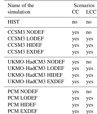
Table 2.List of the different simulations performed with the three LSMs (ORCHIDEE, INLAND-DGVM and LPJmL-DGVM) with or without climate change (CC) and land-cover change (LCC).
Name of the Scenarios
simulation CC LCC
HIST no no
CCSM3 NODEF yes no
CCSM3 LODEF yes yes
CCSM3 HIDEF yes yes
CCSM3 EXDEF yes yes
UKMO-HadCM3 NODEF yes no
UKMO-HadCM3 LODEF yes yes UKMO-HadCM3 HIDEF yes yes UKMO-HadCM3 EXDEF yes yes
PCM NODEF yes no
PCM LODEF yes yes
PCM HIDEF yes yes
PCM EXDEF yes yes
is used to disaggregate shortwave radiation, while the other meteorological variables are interpolated linearly. Additional details of the downscaling and bias-correction methods are described in Moghim et al. (2017).
2.3 Deforestation scenarios
The Amazon Basin is located in the countries of Bolivia, Brazil, Colombia, Ecuador, Peru and Venezuela. Each coun-try in the basin has its own socioeconomic and institutional context-specific aspects to be taken into consideration when building scenarios in order to avoid oversimplifications. Our methodological choice was to generate new updated scenar-ios only for Brazil and Bolivia, the most important deforesta-tion hotspots in the basin. The Brazilian pordeforesta-tion of the basin covers approximately 50 % of the area, being also where most of the deforestation hotspots have been located in the previous decades. Bolivia has also been facing an intensive deforestation process for agricultural expansion around the Santa Cruz area. For the other countries, existing spatial pro-jections were used.
Table 3.List of the GCMs participating in CMIP3 used in this study with their approximate atmospheric horizontal resolution.
Institutes, country Model Resolution References
Name Abbreviations (lat×long)
National Center for Atmospheric Research (NCAR), USA Community Climate System Model CCSM3 1.4 ◦×
1.4◦ Bonan et al. (2002) Parallel Climate Model PCM ∼2.8◦×2.8◦ Washington et al. (2000) Hadley Centre for Climate Prediction
Hadley Centre Coupled Model UKMO-HadCM3 ∼2.5◦×3.75◦ Gordon et al. (2000) and Research/Met Office, UK
not reaching the full potential from an integrated socioeco-nomic, institutional and environmental perspective. Finally, Scenario C is a pessimistic scenario, named “fragmentation”, consisting of a weakening of the conservation efforts of re-cent years, including the depletion of natural resources and the return of high deforestation rates.
To feed the spatial model, only some selected elements of the storylines were used – mainly concerning the natu-ral resources theme: (a) deforestation rates; (b) secondary vegetation dynamics; (c) roads and protected areas network; and (d) law enforcement. The quantification process for the Brazilian Amazon is described in Aguiar et al. (2016). For the Bolivian Amazon, expert-driven premises about these same selected elements were adopted – respecting however the Bolivian socioeconomic and political specificities, as ex-plained in Tejada et al. (2015).
Based on these elements, future maps of forest area were then simulated using the LuccME (Land use and cover change Modeling Environment; http://www.terrame. org/luccme) model framework, generating annual forest cover maps until 2100 on a grid of 25 km2 for the Brazil-ian Amazon (Aguiar et al., 2016) and the BolivBrazil-ian Amazon (Tejada et al., 2015).
LuccME (Aguiar et al., 2012) is a generic framework to build land-use demand–potential–allocation models. Land change decisions are controlled by an allocation mechanism which uses the suitability of each cell for a given land change transition (potential of change) to distribute a given amount (demand) of change in space. LuccME allows the construc-tion of LUCC models combining existing demand, poten-tial and allocation components according to the needs of a given application and scale of analysis. The modelling components adopted to build the LuccME/BRAmazon and LuccME/Bolivia models are based on the ideas of the Clue model (Verburg et al., 2002). In the allocation model, cells with positive change potential will receive a percentage of the annual deforestation rate expected to be allocated to the whole area. The amount of change (i.e. new deforestation) in each cell will be proportional to the cell potential, which is recomputed, every year, considering not only the temporal changes in the spatial drivers but also the distance to previ-ously opened areas.
For the Brazilian Amazon, annual spatially explicit defor-estation maps from 2002 to 2013, provided by the PRODES (Program for the Estimation of Deforestation in the
Brazil-ian Amazon) system (INPE, 2016), were used to calibrate and validate the parameters of the deforestation model, as detailed in Aguiar et al. (2016) (LuccME/BRAmazon). The main drivers are related to accessibility (connection to na-tional markets and distance to markets), protected areas and soil fertility. Using these variables, the model correctly cap-tured the different stages of occupation of the new Amazo-nia frontiers from 2002 to 2013 (Aguiar et al., 2016). The scenario projections generated for the AMAZALERT project cover the period 2014 to 2100. The same premises described by Aguiar et al. (2016) were used to extend the projections from 2050 to 2100. The modelling process for the Bolivian Amazon (LuccME/Bolivia) was similar. The main spatial drivers considered in the model are connectivity to markets, distance to roads, protected areas and slope (Tejada et al., 2015). The observed deforestation data were drawn from the NKMMNH (Noel Kempff Mercado Museum of Natural His-tory; Killeen et al., 2012) from 2001 to 2008. In this case, the scenario projections run from 2009 to 2100, adapting the premises described by Tejada et al. (2015) from 2050 to 2100.
To generate basin-wide LCC projections, the annual spa-tially explicit results for Brazil and Bolivia were combined with the existing “business-as-usual” projection (defined by the continuation of the current trend) to the other countries, based on historical deforestation trends, as part of the EU-funded ROBIN (Role Of Biodiversity In climate change mit-igatioN) project (Eupen et al., 2014).
Table 4.LCC scenarios used in this study.
Qualitative scenarios Quantification of deforestation rates (spatially explicit projections until 2100)
Name Brief storyline Name Brazilian Amazon Bolivian Amazon Other countries
(Aguiar et al., 2016) (Tejada et al., 2015) (Eupen et al., 2014)
A – Sustainability
“Zero” deforestation scenario:
LODEF
Annual rate decreasing Trend of 2005–2008 Same as HIDEF
sustainable land use, to 3900 km2yr−1 until 2013,
protected areas, until 2020, and then then decrease by 50 %
indigenous territories, to 1000 km2yr−1 restrained construction until 2025, and then
of new roads stabilizing until 2100
C – Fragmentation
HIDEF
Annual rate increasing Total deforested area reaches For each country, to 15 000 km2yr−1 13 million ha in 2025 ha, projected until 2020 then replicates the 2005–2008 according to
Return of high and stabilizing until 2100 annual rate historical trends
deforestation rates
EXDEF
Annual rate increasing Same as HIDEF Same as HIDEF
to 19 500 km2yr−1
(1996–2005 historical rate) until 2020 and stabilizing until 2100
2.4 Model results analysis
We selected two 20-year periods, 2040–2059 and 2080– 2099, for LSM output analysis. The impact of future climate change alone was estimated for each LSM by the difference between the results of NODEF and HIST in precipitation, ET, runoff and river discharge (Table 2). The impact of fu-ture LCC was estimated by taking the difference, for each LSM and GCM forcing, between the results of future simu-lations with LCC (LODEF, HIDEF and EXDEF) and without LCC (NODEF). Relative differences are calculated with the same benchmark (HIST simulation).
The spread in the ensemble mean variation (LSMs and GCM forcings) was measured by the interquartile range (IQR). The consistency of the variations in precipi-tation, ET and runoff were estimated by the signs of the first (Q1) and the last (Q3) quartiles. A decrease (increase)
was considered to be consistent ifQ3<0 (Q1>0).
We quantify the relative contribution of GCMs, LSMs and LCC scenarios to uncertainty using an analysis of vari-ance (ANOVA) framework as in, e.g. Yip et al. (2011), San-som et al. (2013) and Giuntoli et al. (2015). ANOVA parti-tions a total sum of squares into porparti-tions associated with the various factors. The effect size statistic is usually calledη2
which quantifies the proportion of total variance attributed to each factor.
3 Results
3.1 Future scenarios 3.1.1 Climate
By the end of the 21st century, GCM-mean annual tempera-ture increases by 3.3◦C in Amazonia. The forcing from the
GCM chosen in this study spans the range of climate predic-tions for Amazonia (Malhi et al., 2009; Zhang et al., 2015). The UKMO-HadCM3 GCM is the driest and warmest model (+4.5◦C), predicting Amazon rainfall reductions twice as large as any other CMIP3 GCM (Covey et al., 2003; Cox et al., 2004); PCM simulates a slightly warmer (+1.7◦C) but wetter future climate compared to the current climate; and CCSM3 falls in between (+3.6◦C) (Zhang et al., 2015).
The strongest warming of 6.1◦C by 2100 is found in
east-ern Amazonia with the UKMO-HadCM3 GCM (not shown). Because of the differences in precipitation changes projected by the three GCMs (between−4.5 and+16.2 %) by the end of the century, the average increase of precipitation by 8.5 % (190 mm yr−1) across the three GCMs should be considered as very uncertain (Fig. 3a). Precipitation changes are also spatially contrasted. Western and northern Amazonia tend to become wetter in all GCM models, with annual precipitation increases going from 6.5 to 11 % (Figs. 3a and 4a). In the upper Solimões and the Branco catchments, the three GCM forcings give an increase of precipitation. Southern Amazo-nia also becomes wetter, in particular the Madeira catchment where the three GCM forcings give a 5 % increase in pre-cipitation (Fig. 3a) but with spatial differences. In the Madre de Dios region (see Fig. 1a for location), at least two out of the three GCM forcings give a decrease in precipitation (Fig. 4a). In south-eastern Amazonia, there is no change in GCM-mean precipitation over the Tapajós and Xingu catch-ments but GCM forcings disagree on the sign and magnitude of the change (Fig. 3a). At least two out of the three GCM forcings give a decrease of precipitation in the western part of the Tapajós catchment (Fig. 4a).
Figure 3.Changes in mean annual (mm yr−1) and August to October (ASO) values (mm month−1) of(a, b)precipitation,(c, d)ET and (e, f)runoff due to climate change only, for the end of the century, over the Amazon Basin and eight of its catchments (the abbreviations of the catchments are indicated in Table S1). Each box plot corresponds to the interquartile range (IQR, distance between the 25th and the 75th percentiles) within each catchment, indicating the spread of the three GCM forcings (for1P) and three GCM forcings×three LSMs (for1ET and1R) results (see Fig. 1 for colour code). For a given box plot, the black points denote the mean value over the catchment, the whiskers extend from the minimum value to the maximum one and the numbers above the box plot indicate the mean relative differences over the catchment (%).
spatial patterns of precipitation changes are similar to annual mean changes, but with a larger area of decreased precipita-tion (Fig. 4a and b). As noticed by Guimberteau et al. (2013), south-eastern Amazonia becomes drier in the middle and at the end of the century, with an average ASO precipitation decrease ranging from 10 to 14 % in the Tapajós and Xingu catchments (Fig. 3b). At least two out of the three GCM forc-ings give a consistent ASO precipitation decrease in most of the grid cells of these two catchments, particularly in the
Figure 4.Maps indicate spatial change in(a)annual (mm yr−1) and(b)ASO (mm month−1) precipitation due to climate change (mean of the three GCM forcings) for the end of the century. The symbols indicate that more than two GCM forcings out of three give a precipitation increase (+) or decrease (−) on the grid cell. The black lines delineate the Amazon Basin and the catchments. Plots indicate the corresponding zonal mean of relative changes in precipitation (%) from the three GCM forcings.
Figure 5. Interannual variation of forest area (106km2) over the Amazon Basin, according to the NODEF scenario, the three LCC scenarios and the SSP of the AR5 RCP8.5 scenario over 2009– 2099. The blue bands indicate the two future periods selected for this study.
3.1.2 Land-cover change
The total area of Amazonian forest prescribed in 2009 is 5.27 million km2, i.e. 89 % of the total area of the whole basin (Fig. 5). The LODEF scenario projects a 7 % decrease in for-est area over the Amazon Basin by 2099 relative to 2009 (Fig. 6). By comparison, the SSP land-use scenario with the RCP8.5 emission scenario, which broadly corresponds to the SRES A2 storyline of the GCM climate forcing used in this study, gives a forest area loss of 4.6 % (Fig. 5), relative to a forest area of 5.03 million km2in 2009. By contrast, in both HIDEF and EXDEF scenarios, forest area strongly declines during the next century. By 2100, according to the EXDEF
Basin AMAZ MAD MAM TAP XIN UPSO PUR JUR BRA -70
-60 -50 -40 -30 -20 -10 0
LODEF HIDEF EXDEF Sub-basins
(%
)
MAIN SOUTH WEST NORTH
Figure 6.Forest area decrease (%) over the different catchments of the Amazon Basin between each of the three LCC scenarios in 2099 and the NODEF scenario in 2009 (the abbreviations of the catch-ments are indicated in Table S1).
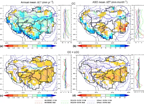
[image:9.612.310.546.311.469.2]Figure 7.Maps indicate spatial change in(a, c)annual (mm yr−1) and(b, d)ASO (mm month−1) ET due to(a, b)climate change (mean of the three GCM forcings) and(c, d)deforestation combined with climate change (EXDEF) for the end of the century. The symbols indicate that more than six simulations out of nine (three GCM forcings×three LSMs) give an increase (+) or a decrease (−) of ET on the grid cell. The black lines delineate the Amazon Basin and the catchments. Plots indicate the corresponding zonal mean of relative changes in ET (%) from each of the nine simulations.
it decreases by approximately 50 % (Fig. 6). The western and northern catchments are projected to lose between 2 and 40 % of their forest area, depending on the LCC scenario.
3.2 Effects of climate change on ET and runoff 3.2.1 Annual mean changes in ET and runoff
The 8.5 % average increase of GCM-estimated annual pre-cipitation (190 mm yr−1) by the end of the century results in
a 5 % increase in ET (54 mm yr−1) and a 14 % increase in
runoff (136 mm yr−1) over the entire Amazon Basin (Fig. 3a, c and e, respectively). The ensemble spread in annual ET variation is lower (IQR=110 mm yr−1; Fig. 3c) than the change in runoff (IQR=420 mm yr−1; Fig. 3e), which is very uncertain. Western parts of the basin become wetter, and ensemble-mean ET and runoff consistently increase by up to 6.5 and 16 %, respectively, with a higher spread for
-1
-1
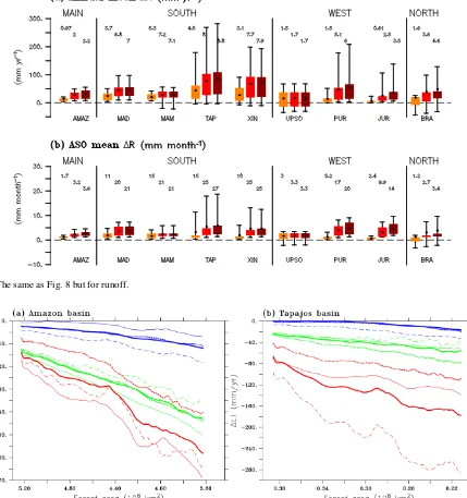
Figure 8. (a)Mean annual (mm yr−1) and(b)ASO values (mm month−1) of ET changes due to deforestation and assuming future climate change, for the end of the century, over the Amazon Basin and eight of its catchments (the abbreviations of the catchments are indicated in Table S1). Each box plot corresponds to the interquartile range (IQR, distance between the 25th and the 75th percentiles) within each catchment indicating the spread of the three GCM forcings×three LSMs results for one LCC scenario (see Fig. 6 for colour code). For a given box plot, the black points denote the mean value over the catchment, the whiskers extend from the minimum value to the maximum one and the numbers above the box plot indicate the mean relative differences over the catchment (%).
spread widely across all the simulations in these catchments (IQR≈430 mm yr−1; Fig. 3e).
3.2.2 South-eastern catchments: ASO changes in ET and runoff
During ASO, the end of the dry season in the south-eastern catchments, reduced precipitation causes a consistent de-crease in ET, e.g. in the Xingu catchment by up to 8 % (10 mm month−1; Fig. 3d), where at least six out of nine simulations give a consistent ET reduction in many south-ern grid cells (Fig. 7b). The spread between all the projec-tions simulating ET decrease is lower for the Tapajós than for the Xingu (IQR is 19 and 27 mm month−1, respectively). Mean-ensemble runoff, already low during ASO in this re-gion, decreases consistently by about 25 % and the ensemble spread is low (IQR<10 mm month−1).
3.3 Effects of deforestation (with background climate change)
3.3.1 Annual mean changes in ET and runoff
Deforestation and climate change led to a consistent decrease in annual ET in the Amazon Basin by the end of the cen-tury of up to 2.6 % (30 mm yr−1) with the EXDEF scenario
(Fig. 8a). The resulting consistent increase of runoff is 2.2 % (Fig. 9a) and both spreads of ET and runoff over the entire basin are small between the multiple forcings and LSMs used (IQR=30 mm yr−1for runoff). With the EXDEF scenario, the loss of forest area leads to a continuous ET reduction throughout the 21st century but of different magnitude de-pending on the simulation type (Fig. 10a). By the end of the 21st century, ORCHIDEE simulates a 58 mm yr−1ET reduc-tion while LPJmL-DGVM gives a decrease of 12 mm yr−1 (multi-GCM forcing mean). In addition, for a given LSM, the decrease of ET differs according to the GCM forcing used, notably in the case of ORCHIDEE which simulates a decrease twice as large with UKMO-HadCM3 than with PCM. In EXDEF, ET is more strongly affected in the south-ern and eastsouth-ern regions where forest area loss is impor-tant (compare Fig. S2f and c). A decrease in ET by up to
∼150 mm yr−1 is obtained in these regions, where at least
[image:11.612.99.496.68.315.2]-1
[image:12.612.88.517.75.532.2]-1
[image:12.612.74.521.321.559.2]Figure 9.The same as Fig. 8 but for runoff.
Figure 10.ET changes (mm yr−1) over 2009–2100 (1-year running mean) as a function of tree area decrease (106km2) from scenario EXDEF within the(a)Amazon and(b)Tapajós catchments.
catchment). In the western and northern catchments, defor-estation induces a maximum consistent ET (runoff) reduction (increase) of less than 6.5 % (6 %) in each catchment.
3.3.2 South-eastern catchments: ASO changes in ET and runoff
During ASO in the south-eastern catchments, ensemble-mean ET consistently decreases by up to 11 % and
mag-nitude. In the Tapajós catchment, in the EXDEF scenario, LPJmL-DGVM exhibits strong water limitations and pro-duces nearly no evaporation of intercepted rainfall, while the bare soil evaporation increases during the wet season. Over the Xingu catchment, ET reduction starts 1 month later in ORCHIDEE (1 month earlier in INLAND-DGVM) than in the Tapajós catchment, and seasonal variation of 1ET does not change with LPJmL-DGVM (Fig. S3d). Over the Madeira catchment, both ORCHIDEE and INLAND-DGVM simulate a small decrease in ET in the EXDEF simulations during the dry season (by up to−10 mm month−1in August) while LPJmL-DGVM produces no change of ET (Fig. S3b). Changes in ET component fluxes have the same signs as in the Tapajós but smaller magnitudes (compare Fig. S4a and b).
3.3.3 South-eastern catchments: uncertainties due to model structure
Deforestation-induced ET variations during the dry season are driven by soil moisture changes which limit ET from dry soils (Juárez et al., 2007; Guimberteau et al., 2014). Thus, ET and runoff variations simulated by the LSMs are strongly linked to their soil hydrology and different soil moisture parameterizations, soil depths (2, 3 and 4 m in the case of ORCHIDEE, LPJmL-DGVM and INLAND-DGVM, respectively) and soil texture maps. Looking at spe-cific model behaviour, e.g. during the dry season in the Tapa-jós catchment for the EXDEF scenario and CCSM3 forcing, we found that deforestation decreases soil moisture in the upper layers in ORCHIDEE and INLAND-DGVM (down to 50 cm and 2 m, respectively) while deeper soil moisture increased in these two LSMs (Fig. 11a). These opposing changes of soil moisture in the soil profile are explained by the substitution of the deep-rooted forests by shallow-rooted pasture and crops in the two LSMs (see de Ros-nay and Polcher, 1998 for ORCHIDEE and Kucharik et al., 2000 for INLAND-DGVM). Short vegetation can only ac-cess water for transpiration from the near-surface layers. The resulting deforestation-induced ASO transpiration de-crease is higher with ORCHIDEE (∼30 mm month−1in Au-gust) than INLAND-DGVM (∼15 mm month−1in the same month). Yet, in both conditions (with or without deforesta-tion), INLAND-DGVM simulates higher ASO transpiration (Fig. 11a). This can be explained by the higher soil wa-ter holding capacity of INLAND-DGVM which enables this LSM to carry over more water from the wet season than OR-CHIDEE. This helps to sustain the evaporation during the dry season, as reported by Guimberteau et al. (2014). The simulated leaf area index (LAI) being higher in INLAND-DGVM than in ORCHIDEE can also explain the differences between the two LSMs in simulated ET (not shown). In con-trast to both ORCHIDEE and INLAND-DGVM, transpira-tion with LPJmL-DGVM is strongly limited by water avail-ability nearly all year round in southern Amazonia. As a
re-Figure 11. Impact of deforestation combined with climate change on ET (mm month−1), transpiration (mm month−1), runoff (mm month−1) and soil moisture (mm) over the Tapajós catch-ment for the three LSMs for two different end-of-century climates: (a)CCSM3 and(b)UKMO-HadCM3. Top panels show seasonal cycle of precipitation (mm month−1) with colour bars and seasonal cycles of ET, transpiration and runoff with plain/dashed lines for NODEF/EXDEF LCC scenarios. Bottom panels show correspond-ing change in soil moisture (mm) due to deforestation combined with climate change. Results for PCM forcing are similar to those for CCSM3 forcing (not shown).
sult of this background limitation even without deforestation, under the EXDEF scenario, soil moisture in the deep layers of LPJmL-DGVM decreases only slightly all year long (by
[image:13.612.311.546.64.434.2]Figure 12.Seasonal river discharge (m3s−1) simulated by ORCHIDEE and LPJmL-DGVM from HIST (averaged over 1970–2008) and from NODEF and EXDEF LCC scenarios (mean of the three GCM forcings for each scenario averaged over 2080–2099) at the gauging stations over the Amazon catchments (the abbreviations of the catchments are indicated in Table S1). The results from HIST simulations are compared with the observations from the SO HYBAM (averaged over 1970–2008). River discharge is not represented for INLAND-DGVM because it does not include a routing scheme.
3.3.4 South-eastern catchments: changes in soil moisture explained by GCM precipitation seasonality in presence of deforestation
The amplitudes of the seasonal cycle of precipitation are dif-ferent between the GCM forcings. In the UKMO-HadCM3 model, the seasonal amplitude is lower than in CCSM3 and PCM (compare Fig. 11a and b). In southern Amazonia, the CCSM3 precipitation drops by 79 % (−300 mm month−1) between March (wettest month) and May (beginning of the dry season). By contrast, the precipitation drop between these two months is 60 % (−180.0 mm month−1) in
UKMO-HadCM3. The influence of precipitation from the GCM forc-ings on the response of soil moisture variation to deforesta-tion depends on the LSM considered. As a result, soil mois-ture is lower all year long with LPJmL-DGVM and OR-CHIDEE forced by UKMO-HadCM3 due to the dry condi-tion of the soil, even if the deforestacondi-tion reduces ET. The largest soil moisture decrease occurs with ORCHIDEE from March to June, during the beginning of the dry season. Thus,
the change in transpiration simulated by this LSM is highly sensitive to the difference in precipitation changes during the wet-to-dry transition period between CCSM3 and UKMO-HadCM3.
3.3.5 Changes in runoff and river discharge
Figure 13.Relative change (%) of the first deciles (i.e. low flow, left panels) and the last deciles (i.e. high flow, right panels) of river discharge due to climate change (grey) and deforestation combined to climate change (three LCC scenarios) of(a)the Madeira (at Fazenda Vista Alegre – FVA) and(b)the Tapajós (at Itaituba – ITA) for the middle (green) and the end (red) of the century. The changes are simulated by the ensemble of six simulations (two LSMs×three GCM forcings). The change of low flows and high flows cannot be represented with INLAND-DGVM because it does not include a routing scheme. The boxes correspond to the interquartile range (IQR, the distance between the 25th and the 75th percentiles), the bold horizontal line in each box is the median and the whiskers extend from the minimum value to the maximum value unless the distance from the minimum (maximum) value to the first (third) quartile is more than 1.5 times the IQR. Circles indicate the outliers that are 1.5×IQR below (above) the 25th percentile (75th percentile).
season in the south (Madeira), where river discharge slightly increases between October and April.
The discharge extremes of the southern rivers (Madeira and Tapajós) are affected by deforestation (Fig. 13). The de-forestation in the EXDEF scenario has an opposite effect compared to the effect of climate change on the low flows in both rivers. Namely, for the Madeira, the deforestation-induced increase of low flow ranges from 3.0 to 10 %, according to different LCC scenarios and compared to a climate-change-induced reduction by 50 % (Fig. 13a). The high-flow increase in the Madeira due to deforestation is very small (up to 1.5 %) when compared to the climate change ef-fect (+15 %). Yet, the spread of the results in the high-flow increase due to climate change is significantly reduced when taking the deforestation into account, suggesting some
4 Discussion and synthesis
4.1 Does deforestation balance or amplify the impact of climate change on the hydrology of the Amazon Basin?
Although with high uncertainties, greenhouse-gas-induced climate change will probably enhance the water cycle in Amazonia, increasing annual precipitation, ET and runoff by the end of the century. The three LSMs used in this study simulate an increase of ET, despite the physiological (anti-transpirant) effect of increased CO2being accounted for in
all of them. However, this behaviour needs to be consid-ered with caution, as it is obtained without considering at-mospheric feedbacks. Considering the land–atmosphere cou-pling, deforestation may change precipitation recycling and thus the sign of the water balance over Amazonia (Coe et al., 2009). Consistent with Cook et al. (2012), Langer-wisch et al. (2013), Guimberteau et al. (2013) and Sorribas et al. (2016), contrasted precipitation changes are projected between southern and western–northern regions. Comparing Figs. 4b and 7b, the most pronounced decrease in ET occurs during the end of the dry season, in agreement with Leje-une et al. (2014), in regions where precipitation declines. ET decreases more than precipitation over all the south-eastern catchments (TAP and XIN); i.e. land surface processes incor-porated in LSMs reduce the evaincor-porated fraction of precipita-tion.
It has been suggested that a reduction in the area of Ama-zonian forest, such as that produced by the EXDEF scenario, will push much of Amazonia into a permanently drier climate regime (Malhi et al., 2008). At an annual scale, deforestation-reduced ET only partly offsets the positive effect of climate change on ET even in EXDEF, so that all the simulations give a net increase of runoff by the end of the century. In south-eastern Amazonia, the ∼50 % forest area loss in EXDEF combined with climate change leads to a consistent ET de-crease which offsets positive changes of ET due to climate change alone. Over the Xingu, our projections of the hydro-logical budget are consistent with Panday et al. (2015), who also found opposite effects of deforestation and climate dur-ing the past 40 years usdur-ing a combination of long-term obser-vations of rainfall and discharge. Yet, our settings of constant land use ignore the influence of historic deforestation on ET and may result in highly biased estimates of deforestation ef-fects on ET.
Generally, the resulting increase of runoff after deforesta-tion is consistent with other studies, such as LCC simula-tions with LSMs at the global scale (Sterling et al., 2013) and LCC experiments on watersheds in the northern Ap-palachians where water yields increase after intensive cut-tings (Rothacher, 1970; Hornbeck et al., 2014). The increase of annual runoff in the Xingu catchment (+8 %), with in-creasing deforestation in the future, is of similar order to the results of Stickler et al. (2013), who found a 10 to 12 %
runoff increase given 40 % deforestation in this catchment. Yet, during ASO in the south-eastern catchments, deforesta-tion amplifies the effect of climate change in reducing ET, in particular in the south of the Tapajós catchment and in the north of the Madeira and Xingu catchments where deforested areas are the largest. Thus, deforestation contributes to the increase in runoff (+27 % in the Tapajós) and thus balances the runoff-reducing effect of climate change (−22 % in the Tapajós).
4.2 Consequences on the extreme discharge of the southern rivers
The ET decrease and runoff increase projected for south-ern catchments (Madeira and Tapajós) by the extreme defor-estation scenario applied here (EXDEF) balances the climate change effect on low flows. Climate change alone increases the seasonal amplitude of discharge and high-flow values. In contrast, deforestation balances this effect by reducing the risk of decrease in low flows in the Madeira and Tapajós in all LCC scenarios; this is related to the decrease of ET dur-ing the dry season. The low-flow increase of the Tapajós is consistent with higher future discharge during the dry sea-son, in the Jamanxim subcatchment (lower Tapajós) (Lam-parter et al., 2016). Our result for the Madeira contradicts those of Siqueira Júnior et al. (2015) who found a decrease of low flows with the hydrological model MHD-INPE, com-bined with the business-as-usual scenario (BAU) of Soares-Filho et al. (2006) where deforestation is lower than in the EXDEF scenario. They argue that this behaviour is due to the occurrence of faster flows when deforestation is taken into account, even though this contradicts the fact that LCC scenarios are associated with reduced ET. This comparison highlights the uncertainty in the results of the effect of defor-estation on hydrology, depending on whether we use LSMs or hydrological models to simulate river discharge.
4.3 Contributions of GCMs, LSMs and land cover change scenarios to total uncertainty in ET and runoff projections
Figure 14.Contributions of GCMs, LCC scenarios, LSMs and interactions between each to total uncertainty in(a)ET and(b)runoff changes, for the end of the century, for the Amazon Basin (bottom right pie chart) and eight of its catchments.
To further distinguish and quantify the uncertainties which originate from the GCMs, LSMs and the LCC scenarios, we used ANOVA. We found that the main uncertainty source is different for ET (Fig. 14a) and runoff (Fig. 14b). On aver-age, over the entire Amazon Basin (OBI), LCC provides the largest uncertainty for ET projections (38 % of total uncer-tainty) but most of the ET variance is unexplained by the studied factors. At the subcatchment scale, in contrast, the ANOVA method identifies the GCMs as the dominant un-certainty source for ET projections. Significant interactions between GCMs and LCC scenarios also occur in the western catchments, suggesting that these contributions do not be-have linearly. Large uncertainties due to LSMs are also found in the southern catchments.
Regarding runoff (Fig. 14b), the overall uncertainty is dominated by the LSMs’ contribution (53 %), particularly in the Xingu and Tapajós catchments (60 %), suggesting the difficulty of these models to simulate contrasted runoff varia-tions that naturally occur during the year in these catchments. Uncertainty in the simulated runoff changes attributable to LCC only occurs in the Branco catchment (22 %), while it is largely attributable to GCMs in southern (up to 91 % in the Madeira) and western (73 % in the upper Solimões) catch-ments.
In summary, at the subcatchment scale, the magnitude of the changes in ET first depends on GCMs and then on the behaviour of each LSM (water-limited versus energy-limited models) in the southern catchments. Conversely, uncertainty in runoff changes in the Amazon Basin (OBI) is first at-tributable to LSMs, particularly in the south-eastern catch-ments, and then to GCMs. The uncertainty attributable to LCC is low in these catchments, suggesting some robust-ness in the response of the hydrology to the deforestation.
Thus, our study emphasizes the uncertainty associated with the choice of the LSMs and their inherent (energy-limited or water-limited) parameterizations in the estimation of defor-estation impacts on runoff. Over large river basins like the Amazon, these models have the disadvantage of being rather poorly constrained in their parameterizations of both vege-tation functioning (Poulter et al., 2010) and soil hydrology (Christoffersen et al., 2014). In our view, the LSM commu-nity needs to strengthen its efforts to cooperate with the soil science community to improve the representation of soil hy-drological processes in their models, despite the difference in scale at which they work and the inherent small-scale vari-ability of soil properties.
5 Conclusions
The construction of new land-cover change scenarios for Amazonia indicates that, by the end of this century, the to-tal forested area of the Amazon Basin will have decreased by 7 % in the best case to 34 % in the most severe scenario. The most severe forest clearing occurs in southern Amazo-nia where the Madeira, Xingu and Tapajós catchments ex-perience a 50 % decrease in forest area. With a multi-model approach, we found that the replacement of the forests by pasture and crops should only slightly decrease annual evap-otranspiration by up to 2.5 % and enhance runoff by up to 2.2 %, for the most severe scenario of the Amazon Basin, compared to simulations with climate change only.
evapotranspiration may drop by−9 and−11 % in the Xingu and Tapajós catchments, respectively, with deforestation am-plifying the decrease of ET due to climate change alone. The dominant uncertainty associated with these results comes from the climate change scenarios. In contrast, by enhancing the runoff, the deforestation balances the negative effect of climate change on runoff in these catchments. As a result, the deforestation in the most intensive scenario balances the risk of decrease in low flows of the Tapajós due to climate change by the end of the century. In these catchments, LSMs are the largest uncertainty source for runoff projections, while the climate change uncertainty dominates in the southern catch-ments (Madeira and Mamoré). Our results in the Tapajós catchment emphasize the impact of deforestation combined with climate change on hydrological extremes. The defor-estation leads to a 12.5 % increase in low flows by the end of the century, which balances the opposite impact of climate change.
Biosphere–atmosphere interactions, not accounted for in our study, are also crucial in estimating the progress of forest dieback, whereby forest is replaced by savanna vegetation. During the end of the dry season, we found a strong reduction of ET in south-eastern Amazonia. Evaporation at this time of year provides a critical source of water vapour for precipi-tation, and lower ET can delay the onset of the wet season (Fu and Li, 2004) and reduce the water recycling during this period (Lima et al., 2014). We need to pay careful attention to the intensification and lengthening of droughts during this century, a phenomenon that is commonly predicted by the GCMs for southern Amazonia (Boisier et al., 2015). What-ever its cause, our results emphasize the need to include the deforestation process in climate change simulations. Defor-estation has the potential to mask (or unmask) the effects of climate change on surface hydrology.
Code and data availability. The version of the ORCHIDEE model
used for this study is Trunk.rev1311. The source code of the ORCHIDEE model can be obtained upon request (see http: //labex.ipsl.fr/orchidee/index.php/contact). Documentation on the code, including scientific and technical aspects, is available here: https://vesg.ipsl.upmc.fr/thredds/fileServer/IPSLFS/orchidee/ DOXYGEN/webdoc_2425/index.html.
The Supplement related to this article is available online at doi:10.5194/hess-21-1455-2017-supplement.
Competing interests. The authors declare that they have no conflict
of interest.
Acknowledgements. This work was financially supported by the
EU-FP7 AMAZALERT (Raising the alert about critical feedbacks between climate and long-term land-use change in the Amazon) project (grant agreement no. 282664) and the European Research Council Synergy grant ERC-2013-SyG-610028 IMBALANCE-P.
We acknowledge the SO HYBAM team which provided their river flow data sets for the Amazon Basin (http://www.ore-hybam.org). Simulations with ORCHIDEE were performed using computational facilities of the Institut du Déeloppement et des Ressources en Informatique Scientifique (IDRIS, CNRS, France). The authors gratefully acknowledge John Gash for proofreading and correcting the English edition of the manuscript.
Edited by: F. Fenicia
Reviewed by: T. Roy and two anonymous referees
References
Aguiar, A. P. D., Ometto, J. P., Nobre, C., Lapola, D. M., Almeida, C., Vieira, I. C., Soares, J. V., Alvala, R., Saatchi, S., Valeriano, D., and Castilla-Rubio, J. C.: Modeling the spatial and tempo-ral heterogeneity of deforestation-driven carbon emissions: the INPE-EM framework applied to the Brazilian Amazon, Global Change Biol., 18, 3346–3366, 2012.
Aguiar, A. P. D., Vieira, I. C. G., Assis, T. O., Dalla-Nora, E. L., Toledo, P. M., Oliveira Santos-Junior, R. A., Batistella, M., Coelho, A. S., Savaget, E. K., Aragão, L. E. O. C., Nobre, C. A., and Ometto, J.-P. H.: Land use change emission scenarios: an-ticipating a forest transition process in the Brazilian Amazon?, Global Change Biol., 22, 1821–1840, doi:10.1111/gcb.13134, 2016.
Alcamo, J. (Ed.): Chapter Six. The SAS Approach: Combining Qualitative and Quantitative Knowledge in Environmental Sce-narios, in: Environmental Futures The Practice of Environmental Scenario Analysis, vol. 2 of Developments in Integrated Environ-mental Assessment, Elsevier, Amsterdam, the Netherlands, 123– 150, doi:10.1016/S1574-101X(08)00406-7, 2008.
Alves, D. S.: Space-time dynamics of deforestation in Brazilian Amazonia, Int. J. Remote Sens., 23, 2903–2908, 2002.
Assunção, J., Gandour, C. C., and Rocha, R.: Deforestation slow-down in the Legal Amazon: prices or policies, Clim. Policy Ini-tiat., 1, 03–37, 2012.
Barni, P. E., Pereira, V. B., Manzi, A. O., and Barbosa, R. I.: De-forestation and forest fires in Roraima and their relationship with phytoclimatic regions in the Northern Brazilian Amazon, Envi-ron. Manage., 55, 1124–1138, 2015.
Becker, B. K.: Amazônia, 5th Edn., editions Atica, Sao Paulo, p. 112, 1997.
Becker, B. K.: Amazônia: geopolítica na virada do III milênio, Ed-itora Garamond, Rio de Janeiro, Brazil, 2004.
Biemans, H., Hutjes, R., Kabat, P., Strengers, B., Gerten, D., and Rost, S.: Effects of precipitation uncertainty on discharge calcu-lations for main river basins, J. Hydrometeorol., 10, 1011–1025, 2009.
Boisier, J.-P., Ciais, P., Ducharne, A., and Guimberteau, M.: Pro-jected strengthening of Amazonian dry season by constrained cli-mate model simulations, Nat. Clim. Change, 5, 656–660, 2015. Bonan, G. B., Oleson, K. W., Vertenstein, M., Levis, S., Zeng, X.,
Dai, Y., Dickinson, R. E., and Yang, Z.-L.: The land surface cli-matology of the community land model coupled to the NCAR community climate model, J. Climate, 15, 3123–3149, 2002. Boucher, D., Roquemore, S., and Fitzhugh, E.: Brazil’s success in
Callède, J., Ronchail, J., Guyot, J., and Oliveira, E.: Déboisement amazonien: son influence sur le débit de l’Amazone à Óbidos (Brésil), Rev. Sci. Eau, 21, 59–72, 2008.
Christoffersen, B. O., Restrepo-Coupe, N., Arain, M. A., Baker, I. T., Cestaro, B. P., Ciais, P., Fisher, J. B., Galbraith, D., Guan, X., Gulden, L., van den Hurk, B., Ichii, K., Imbuzeiro, H., Jain, A., Levine, N., Miguez-Macho, G., Poulter, B., Roberti, D., Sak-aguchi, K., Sahoo, A., Schaefer, K., Shi, M., Verbeeck, H., Yang, Z.-L., Araujo, A. C., Kruijt, B., Manzi, A. O., da Rocha, H. R., von Randow, C., Muza, M. N., Borak, J., Costa, M. H., de Goncalves, L. G. G., Zeng, X., and Saleska, S. R.: Mecha-nisms of water supply and vegetation demand govern the sea-sonality and magnitude of evapotranspiration in Amazonia and Cerrado, Agr. Forest Meteorol., 191, 33–50, 2014.
Coe, M., Costa, M., and Soares-Filho, B.: The influence of historical and potential future deforestation on the stream flow of the Ama-zon River-Land surface processes and atmospheric feedbacks, J. Hydrol., 369, 165–174, 2009.
Cook, B., Zeng, N., and Yoon, J.: Will Amazonia dry out: Magni-tude and Causes of change from IPCC climate model projections, Earth Interact., 16, 1–27, 2012.
Costa, M. H. and Pires, G. F.: Effects of Amazon and Central Brazil deforestation scenarios on the duration of the dry season in the arc of deforestation, Int. J. Climatol., 30, 1970–1979, 2010. Covey, C., AchutaRao, K. M., Cubasch, U., Jones, P., Lambert, S.
J., Mann, M. E., Phillips, T. J., and Taylor, K. E.: An overview of results from the Coupled Model Intercomparison Project, Global Planet. Change, 37, 103–133, 2003.
Cox, P. M., Betts, R., Collins, M., Harris, P., Huntingford, C., and Jones, C.: Amazonian forest dieback under climate-carbon cycle projections for the 21st century, Theor. Appl. Climatol., 78, 137– 156, 2004.
Dalla-Nora, E. L., de Aguiar, A. P. D., Lapola, D. M., and Woltjer, G.: Why have land use change models for the Amazon failed to capture the amount of deforestation over the last decade?, Land Use Policy, 39, 403–411, 2014.
de Rosnay, P. and Polcher, J.: Modelling root water uptake in a com-plex land surface scheme coupled to a GCM, Hydrol. Earth Syst. Sci., 2, 239–255, doi:10.5194/hess-2-239-1998, 1998.
Dias, L. C. P., Macedo, M. N., Costa, M. H., Coe, M. T., and Neill, C.: Effects of land cover change on evapotranspiration and streamflow of small catchments in the Upper Xingu River Basin, Central Brazil, J. Hydrol. Reg. Stud., 4, 108–122, 2015. Eupen, V. M., Cormont, A., Kok, K., Simoes, M., Pereira, R.,
and Kolb, M.: D2. 2.1 Modelling Land Use Change in Latin America, EU, 2014 (Deliverable 2.2.1), Public report: Deliv-erable 2.2.1 EU-FP7 Collaborative Project number: 283093, ROBIN project, Wageningen, the Netherlands, p. 70, available at: http://robinproject.info/home/products/deliverables-2/ (last ac-cess: 10 May 2016), 2014.
Fearnside, P. M.: Deforestation in Brazilian Amazonia: history, rates, and consequences, Conserv. Biol., 19, 680–688, 2005. Foley, J. A., Prentice, I. C., Ramankutty, N., Levis, S., Pollard, D.,
Sitch, S., and Haxeltine, A.: An integrated biosphere model of land surface processes, terrestrial carbon balance, and vegetation dynamics, Global Biogeochem. Cy., 10, 603–628, 1996. Fu, R. and Li, W.: The influence of the land surface on the transition
from dry to wet season in Amazonia, Theor. Appl. Climatol., 78, 97–110, 2004.
Gash, J. H. C., Huntingford, C., Marengo, J. A., Betts, R. A., Cox, P. M., Fisch, G., Fu, R., Gandu, A. W., Harris, P. P., Machado, L. A. T., von Randow, C., and Dias, M. A. S.: Amazonian climate: results and future research, Theor. Appl. Climatol., 78, 187–193, doi:10.1007/s00704-004-0052-9, 2004.
Giuntoli, I., Vidal, J.-P., Prudhomme, C., and Hannah, D. M.: Fu-ture hydrological extremes: the uncertainty from multiple global climate and global hydrological models, Earth Syst. Dynam., 6, 267–285, doi:10.5194/esd-6-267-2015, 2015.
Gordon, C., Cooper, C., Senior, C. A., Banks, H., Gregory, J. M., Johns, T. C., Mitchell, J. F., and Wood, R. A.: The simulation of SST, sea ice extents and ocean heat transports in a version of the Hadley Centre coupled model without flux adjustments, Clim. Dynam., 16, 147–168, 2000.
Guimberteau, M., Drapeau, G., Ronchail, J., Sultan, B., Polcher, J., Martinez, J. M., Prigent, C., Guyot, J. L., Cochonneau, G., Es-pinoza, J. C., Filizola, N., Fraizy, P., Lavado, W., De Oliveira, E., Pombosa, R., Noriega, L., and Vauchel, P.: Discharge sim-ulation in the sub-basins of the Amazon using ORCHIDEE forced by new datasets, Hydrol. Earth Syst. Sci., 16, 911–935, doi:10.5194/hess-16-911-2012, 2012.
Guimberteau, M., Ronchail, J., Espinoza, J. C., Lengaigne, M., Sul-tan, B., Polcher, J., Drapeau, G., Guyot, J. L., Ducharne, A., and Ciais, P.: Future changes in precipitation and impacts on extreme streamflow over Amazonian sub-basins, Environ. Res. Lett., 8, 014035, doi:10.1088/1748-9326/8/1/014035, 2013.
Guimberteau, M., Ducharne, A., Ciais, P., Boisier, J.-P., Peng, S., De Weirdt, M., and Verbeeck, H.: Testing conceptual and physically based soil hydrology schemes against observations for the Amazon Basin, Geosci. Model Dev., 7, 1115–1136, doi:10.5194/gmd-7-1115-2014, 2014.
Hornbeck, J. W., Bailey, A. S., Eager, C., and Campbell, J. L.: Com-parisons with results from the Hubbard Brook Experimental For-est in the northern Appalachians, Long-term response of a forFor-est watershed ecosystem, in: Clearcutting in the southern Appalachi-ans, Oxford University Press, Oxford, 213–228, 2014.
Huffman, G., Adler, R., Morrissey, M., Bolvin, D., Curtis, S., Joyce, R., McGavock, B., and Susskind, J.: Global precipitation at one-degree daily resolution from multisatellite observations, J. Hy-drometeorol., 2, 36–50, 2001.
Huffman, G., Bolvin, D., Nelkin, E., Wolff, D., Adler, R., Gu, G., Hong, Y., Bowman, K., and Stocker, E.: The TRMM multi-satellite precipitation analysis (TMPA): Quasi-global, multiyear, combined-sensor precipitation estimates at fine scales, J. Hy-drometeorol., 8, 38–55, 2007.
INPE: Annual deforestation rates recorded in the Brazilian Ama-zon since 1988, Tech. rep., Brazilian National Institute for Space Research, São Paulo, Brazil, 2016.
IPCC: Climate Change 2013: The Physical Science Basis. Contri-bution of Working Group I to the Fifth Assessment Report of the Intergovernmental Panel on Climate Change, Cambridge Univer-sity Press (CUP), doi:10.1017/cbo9781107415324, 2013. Juárez, R. I. N., Hodnett, M. G., Fu, R., Goulden, M. L., and
von Randow, C.: Control of dry season evapotranspiration over the Amazonian forest as inferred from observations at a southern Amazon forest site, J. Climate, 20, 2827–2839, 2007.
Nobre, C., Sampaio, G., and Seiler, C.: Report on impacts of cli-mate change and IPCC RCP land use scenarios in Earth System Models, Tech. Rep., AMAZALERT Delivery Report WP3, De-livery 3.1, AMAZALERT project, Wageningen, the Netherlands, 2013.
Keller, M., Bustamante, M., Gash, J., and Dias, P. S.: Amazonia and Global Change, Geophys. Monogr. Ser., vol. 186, AGU, Wash-ington, D.C., 2009.
Killeen, T., Soria, L., Quezada, B., Guerra, A., Calderon, V., Clazadilla, M., and Steininger, M.: Mapa de Cobertura de la Tierra y Deforestacion hasta 2008, Museum of Natural History Noel Kempff Mercado, Santa Cruz, Bolivia, 2012.
Kistler, R., Kalnay, E., Collins, W., Saha, S., White, G., Woollen, J., Chelliah, M., Ebisuzaki, W., Kanamitsu, M., Kousky, V., van den Dool, H., Jenne, R., and Fiorino, M.: The NCEP-NCAR 50-year reanalysis: Monthly means CD-ROM and documentation, B. Am. Meteorol. Soc., 82, 247–267, 2001.
Krinner, G., Viovy, N., de Noblet-Ducoudre, N., Ogee, J., Polcher, J., Friedlingstein, P., Ciais, P., Sitch, S., and Prentice, I.: A dynamic global vegetation model for studies of the coupled atmosphere–biosphere system, Global Biogeochem. Cy., 19, 1– 33, doi:10.1029/2003GB002199, 2005.
Kucharik, C. J., Foley, J. A., Delire, C., Fisher, V. A., Coe, M. T., Lenters, J. D., Young-Molling, C., Ramankutty, N., Norman, J. M., and Gower, S. T.: Testing the performance of a dynamic global ecosystem model: water balance, carbon balance, and veg-etation structure, Global Biogeochem. Cy., 14, 795–825, 2000. Lamparter, G., Nobrega, R. L. B., Kovacs, K., Amorim, R. S.,
and Gerold, G.: Modelling hydrological impacts of agricul-tural expansion in two macro-catchments in Southern Amazonia, Brazil, Reg. Environ. Change, doi:10.1007/s10113-016-1015-2, in press, 2016.
Langerwisch, F., Rost, S., Gerten, D., Poulter, B., Rammig, A., and Cramer, W.: Potential effects of climate change on inundation patterns in the Amazon Basin, Hydrol. Earth Syst. Sci., 17, 2247– 2262, doi:10.5194/hess-17-2247-2013, 2013.
Lapola, D. M., Schaldach, R., Alcamo, J., Bondeau, A., Msangi, S., Priess, J. A., Silvestrini, R., and Soares-Filho, B. S.: Impacts of climate change and the end of deforestation on land use in the Brazilian Legal Amazon, Earth Interact., 15, 1–29, 2011. Laurance, W. F., Cochrane, M. A., Bergen, S., Fearnside, P. M.,
Delamônica, P., Barber, C., D’Angelo, S., and Fernandes, T.: The future of the Brazilian Amazon, Science, 291, 438–439, 2001. Lejeune, Q., Davin, E. L., Guillod, B. P., and Seneviratne, S. I.:
In-fluence of Amazonian deforestation on the future evolution of regional surface fluxes, circulation, surface temperature and pre-cipitation, Clim. Dynam., 44, 2769–2786, 2014.
Li, W., Fu, R., and Dickinson, R.: Rainfall and its seasonality over the Amazon in the 21st century as assessed by the coupled mod-els for the IPCC AR4, J. Geophys. Res.-Atmos., 111, D02111, doi:10.1029/2005JD006355, 2006.
Lima, L. S., Coe, M. T., Soares Filho, B. S., Cuadra, S. V., Dias, L. C., Costa, M. H., Lima, L. S., and Rodrigues, H. O.: Feedbacks between deforestation, climate, and hydrology in the Southwest-ern Amazon: implications for the provision of ecosystem ser-vices, Landsc. Ecol., 29, 261–274, 2014.
Lyra, A. D. A., Chou, S. C., and Sampaio, G. D. O.: Sensitivity of the Amazon biome to high resolution climate change projections, Acta Amazon., 46, 175–188, 2016.
Macedo, M. N., DeFries, R. S., Morton, D. C., Stickler, C. M., Galford, G. L., and Shimabukuro, Y. E.: Decoupling of de-forestation and soy production in the southern Amazon dur-ing the late 2000s, P Natl. Acad. Sci. USA, 109, 1341–1346, doi:10.1073/pnas.1111374109, 2012.
Malhi, Y., Roberts, J., Betts, R., Killeen, T., Li, W., and Nobre, C.: Climate change, deforestation, and the fate of the Amazon, Sci-ence, 319, 169–172, 2008.
Malhi, Y., Aragão, L. E., Galbraith, D., Huntingford, C., Fisher, R., Zelazowski, P., Sitch, S., McSweeney, C., and Meir, P.: Explor-ing the likelihood and mechanism of a climate–change-induced dieback of the Amazon rainforest, P. Natl. Acad. Sci. USA, 106, 20610–20615, 2009.
Malingreau, J., Eva, H., and De Miranda, E.: Brazilian Amazon: a significant five year drop in deforestation rates but figures are on the rise again, Ambio, 41, 309–314, 2012.
Moghim, S., McKnight, S. L., Zhang, K., Ebtehaj, A. M., Knox, R. G., Bras, R. L., Moorcroft, P. R., and Wang, J.: Bias-corrected data sets of climate model outputs at uniform space–time resolu-tion for land surface modelling over Amazonia, Int. J. Climatol., 37, 621–636, doi:10.1002/joc.4728, 2017.
Moran, E. F.: Deforestation and land use in the Brazilian Amazon, Hum. Ecol., 21, 1–21, doi:10.1007/bf00890069, 1993.
Nepstad, D., McGrath, D., Stickler, C., Alencar, A., Azevedo, A., Swette, B., Bezerra, T., DiGiano, M., Shimada, J., da Motta, R. S., Armijo, E., Castello, L., Brando, P., Hansen, M. C., McGrath-Horn, M., Carvalho, O., and Hess, L.: Slow-ing Amazon deforestation through public policy and interven-tions in beef and soy supply chains, Science, 344, 1118–1123, doi:10.1126/science.1248525, 2014.
Nóbrega, R. S.: Impacts of Deforestation on Climate and Water Re-sources in Western Amazon, in: chap. 2, edited by: Moutinho, P., InTech, Rijeka, Croatia, 386 pp., doi:0.5772/1979, 2012. Panday, P. K., Coe, M. T., Macedo, M. N., Lefebvre, P., and
de Almeida Castanho, A.: Deforestation offsets water balance changes due to climate variability in the Xingu River in eastern Amazonia, J. Hydrol., 523, 822–829, 2015.
Poulter, B., Hattermann, F., Hawkins, E., Zaehle, S., Sitch, S., Restrepo-Coupe, N., Heyder, U., and Cramer, W.: Robust dy-namics of Amazon dieback to climate change with perturbed ecosystem model parameters, Global Change Biol., 16, 2476– 2495, 2010.
Raskin, P. D.: Global scenarios: background review for the Millen-nium Ecosystem Assessment, Ecosystems, 8, 133–142, 2005. Rothacher, J.: Increases in water yield following clear-cut
log-ging in the Pacific northwest, Water Resour. Res., 6, 653–658, doi:10.1029/wr006i002p00653, 1970.
Sansom, P. G., Stephenson, D. B., Ferro, C. A. T., Zappa, G., and Shaffrey, L.: Simple Uncertainty Frameworks for Select-ing WeightSelect-ing Schemes and InterpretSelect-ing Multimodel Ensem-ble Climate Change Experiments, J. Climate, 26, 4017–4037, doi:10.1175/jcli-d-12-00462.1, 2013.
Sheffield, J., Goteti, G., and Wood, E.: Development of a 50-year high-resolution global dataset of meteorological forcings for land surface modeling, J. Climate, 19, 3088–3111, 2006.
Sitch, S., Smith, B., Prentice, I., Arneth, A., Bondeau, A., Cramer, W., Kaplan, J., Levis, S., Lucht, W., Sykes, M., Thonicke, K., and Venevsky, S.: Evaluation of ecosystem dynamics, plant ge-ography and terrestrial carbon cycling in the LPJ dynamic global vegetation model, Global Change Biol., 9, 161–185, 2003. Soares-Filho, B. S., Nepstad, D. C., Curran, L. M., Cerqueira, G. C.,
Garcia, R. A., Ramos, C. A., Voll, E., McDonald, A., Lefebvre, P., and Schlesinger, P.: Modelling conservation in the Amazon basin, Nature, 440, 520–523, 2006.
Song, X.-P., Huang, C., Saatchi, S. S., Hansen, M. C., and Town-shend, J. R.: Annual Carbon Emissions from Deforestation in the Amazon Basin between 2000 and 2010, PLoS One, 10, e0126754, doi:10.1371/journal.pone.0126754, 2015.
Sorribas, M. V., Paiva, R. C., Melack, J. M., Bravo, J. M., Jones, C., Carvalho, L., Beighley, E., Forsberg, B., and Costa, M. H.: Pro-jections of climate change effects on discharge and inundation in the Amazon basin, Climatic Change, 136, 555–570, 2016. Sterling, S., Ducharne, A., and Polcher, J.: The impact of global
land-cover change on the terrestrial water cycle, Nat. Clim. Change, 3, 385–390, doi:10.1038/nclimate1690, 2013.
Stickler, C. M., Coe, M. T., Costa, M. H., Nepstad, D. C., McGrath, D. G., Dias, L. C., Rodrigues, H. O., and Soares-Filho, B. S.: Dependence of hydropower energy generation on forests in the Amazon Basin at local and regional scales, P. Natl. Acad. Sci. USA, 110, 9601–9606, 2013.
Tejada, G., Dalla-Nora, E., Cordoba, D., Lafortezza, R., Ovando, A., Assis, T., and Aguiar, A. P.: Deforestation scenar-ios for the Bolivian lowlands, Environ. Res., 144, 49–63, doi:10.1016/j.envres.2015.10.010, 2015.
Torres, R. R. and Marengo, J. A.: Uncertainty assessments of cli-mate change projections over South America, Theor. Appl. Cli-matol., 112, 253–272, 2013.
Vera, C., Silvestri, G., Liebmann, B., and González, P.: Climate change scenarios for seasonal precipitation in South Amer-ica from IPCC-AR4 models, Geophys. Res. Lett., 33, L13707, doi:10.1029/2006GL025759, 2006.
Verburg, P. H., Soepboer, W., Veldkamp, A., Limpiada, R., Espal-don, V., and Mastura, S. S.: Modeling the spatial dynamics of re-gional land use: the CLUE-S model, Environ. Manage., 30, 391– 405, 2002.
Washington, W., Weatherly, J., Meehl, G., Semtner Jr., A., Bettge, T., Craig, A., Strand Jr., W., Arblaster, J., Wayland, V., James, R., and Zhang, Y.: Parallel climate model (PCM) control and tran-sient simulations, Clim. Dynam., 16, 755–774, 2000.
Yip, S., Ferro, C. A. ., Stephenson, D. B., and Hawkins, E.: A Simple, Coherent Framework for Partitioning Uncer-tainty in Climate Predictions, J. Climate, 24, 4634–4643, doi:10.1175/2011jcli4085.1, 2011.