THE DIFFUSION OF NEOLITHIC
PRACTICES FROM ANATOLIA TO EUROPE
A Contextual Study of Residential
And Construction Practices
8,500-5,500 BC cal.
THESIS SUBMITTED IN ACCORDANCE WITH THE REQUIREMENTS OF THE UNIVERSITY OF LIVERPOOL FOR THE DEGREE OF
DOCTOR IN PHILOSOPHY
Maxime Nicolas Brami
iii
Supervisor: Professor D. Baird
Co-supervisors: Dr. D.P. Shankland
Professor J.A.J. Gowlett
Examiners:
Dr. J.A. Pearson
v
The Diffusion of Neolithic Practices from Anatolia to Europe.
A Contextual Study of Residential and Construction Practices. 8,500-5,500 BC cal.
Maxime N. Brami
Ever since Vere Gordon Childe’s seminal work on The Dawn of European Civilization (Childe 1925), it has been widely accepted that European agriculture originated in Southwest Asia. Exactly how farming spread to Europe from its origins in Southwest Asia remains, however, a matter of debate. Much of the argument has revolved around the manners of spreading of the Neolithic, whether through colonisation, acculturation or a combination of both. Far less attention has been given to the actual content of the Neolithic pattern of existence that spread into Europe.
In my thesis, I review one particular type of content, practices, defined by reference to the theories of social action as normative acts or ways of doing. Practices are marked out by repetitive patterns in the material record, such as burnt houses for the practice of house-burning. Accordingly, practices are inferred, rather than instantiated, from their material expression, using information about the context and the sequence of stratigraphic events. Beyond farming practices, the Neolithic witnessed the inception of a new set of residential and construction practices, pertaining to the way in which houses were built, lived in and discarded at the end of their use-lives. This research tracks each of five main areas of practices from their origins in the Near East: house ‘closure’, house replacement, residential burial, spatial organisation in the rectangular house and agglutination.
The aim is to examine whether some of the more distinctive Near Eastern practices, such as the deliberate infilling of houses at ‘closure’, the vertical superimposition of houses, the burial of the dead under active households, the spatial division of the main room into two flooring areas and the agglutination of houses in cellular house patterns, spread into Europe. I find that this older habitus of practices, which was involved in upholding a static repetition, house upon house, of the same pattern of existence, did not spread or only marginally into Europe. Over the course of the 7th millennium BC cal., however, it was superseded by another habitus of practices with a focus on collective action, which had wider relevance and appeal. The sequence of Çatalhöyük East, which spans both horizons of practices, serves as a guide to examine the broader dynamics of change in this period.
vi
Table of Contents
List of Figures ... ix
List of Tables ... xi
Acknowledgements ... xv
Introduction ... 1
Chapter 1. A Fast-Tracked Revolution? The Neolithic Transition in Europe as Seen in the East ... 5
1.1 The Neolithic: a changing definition ... 5
1.1.1 The Neolithic stage of culture ... 6
1.1.2 Food-gatherers and food-producers ... 7
1.1.3 The Neolithic ‘Revolution’ ... 9
1.1.4 More than one Neolithic? ... 10
1.2 The two Neolithics of Anatolia ... 13
1.2.1 Anatolia, a land of two continents ... 14
1.2.2 The two thousand year lag: introducing the 14C Backbone ... 17
1.2.3 A fault-line between Central and Western Anatolia ... 23
1.3 Statement of the hypothesis ... 30
Chapter 2. Approaches to the Spread of the Neolithic into Europe ... 33
2.1 A brief history of the research question ... 33
2.1.1 The search for the missing link ... 34
2.1.2 Regionalisation of scholarship? ... 37
2.1.3 Reviving the grand narrative ... 40
2.2 Current approaches of the spread of farming... 42
2.2.1 When did farming spread to Europe? ... 44
2.2.2 Who spread farming? ... 46
2.2.3 Along which routes did farming spread? ... 49
2.2.4 What was spread? ... 51
2.3 Statement of the aims ... 55
Chapter 3. A Method Based on Practices ... 57
3.1 Beyond similarities in material culture ... 57
3.2 Theoretical basis ... 60
3.2.1 A theory of action without agency ... 61
3.2.2 Practice and habitus ... 61
3.2.3 Change of practice ... 63
3.3 Outline of the approach ... 64
3.3.1 Practices with a material expression ... 64
3.3.2 Residential and construction practices ... 65
3.3.3 Contextual evidence ... 68
3.3.4 Interrelationship of practices ... 69
3.4 Data collection ... 70
3.4.1 Fieldwork ... 71
3.4.2 Nature of sources ... 72
3.4.3 Scope and terminology ... 73
vii
Chapter 4. House ‘Closure’ ... 75
4.1 House infilling ... 76
4.1.1 Deliberate infilling and utilitarian levelling ... 77
4.1.2 Types of infill deposits ... 78
4.1.3 ‘Closure’ and renewal ... 79
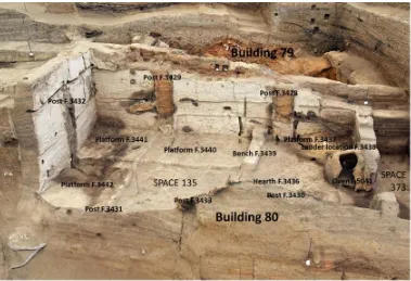
4.2 The case of Building 80 at Çatalhöyük and the dynamics of change ... 80
4.3 House burning ... 84
4.3.1 The intentionality of burning ... 85
4.3.2 Burnt houses in Central and Southwest Anatolia ... 86
4.3.3 The destruction of entire horizons of houses ... 89
4.3.4 Why ‘close’ houses with fire? ... 92
4.4 Summary... 95
Chapter 5. House Replacement... 97
5.1 Building on a tell ... 98
5.1.1 Tells and non-tells ... 99
5.1.2 On the distribution of tells ... 101
5.1.3 Mound formation and social practices ... 103
5.2 Vertical superimposition of houses... 106
5.2.1 Re-cut houses and the onset of sedentism ... 107
5.2.2 Walls upon walls in Central Anatolia ... 110
5.2.3 Building plots in the Eastern Marmara region ... 115
5.2.4 Repeated houses in Greece ... 116
5.3 Horizontal displacement of houses ... 119
5.3.1 Shifts in the focus of occupation in Çatalhöyük V-IV ... 120
5.3.2 Horizontally drifting villages: Hacılar IX-I ... 121
5.4 Summary... 124
Chapter 6. Residential Burial ... 127
6.1 Sub-floor burial ... 129
6.1.1 Burial under the floor of an active household: an archaeological definition ... 131
6.1.2 Living with the dead in Central Anatolia ... 133
6.1.3 Burial under floorboards in Northwest Anatolia? ... 137
6.2 In-fill and inter-dwelling burials ... 141
6.2.1 New burial forms on the Anatolian Plateau ... 142
6.2.2 Intra-settlement burial: context of deposition and methodological implications ... 144
6.2.3 Communal burial grounds in the Eastern Marmara region ... 146
6.2.4 A conspicuous absence of burials: accounting for the exception ... 149
6.3 Summary... 153
Chapter 7. Spatial Organisation in the Rectangular House ... 155
7.1 Large room with an open floor plan ... 156
7.1.1 Near Eastern origins of the rectangular plan ... 157
7.1.2 Multi-roomed buildings in the Northern Levant ... 159
7.1.3 Scale up of the main room ... 162
7.1.4 Incorporation of domestic features in the fabric of the building ... 166
7.2 Division of the space into two flooring areas ... 168
7.2.1 The Çatalhöyük East house ... 169
7.2.2 The Ilıpınar VI house ... 172
7.3 Axial orientation of the oven and the main doorway ... 174
7.3.1 Changes at Çatalhöyük... 175
7.3.2 The Hacılar VI house ... 176
7.3.3 The ‘big house’ at Sofia-Slatina ... 178
viii
Chapter 8. Agglutination ... 183
8.1 Cellular house pattern ... 184
8.1.1 Contemporaneity on a horizontal plan ... 185
8.1.2 Radial boundaries ... 188
8.1.3 Terraces ... 192
8.2 Courtyard-house complexes ... 194
8.2.1 Emergence of courtyards at Çatalhöyük ... 196
8.2.2 Defended ‘farmsteads’ in Southwest Anatolia ... 197
8.2.3 Houses and courts in Middle Neolithic Greece ... 200
8.3 Row houses... 201
8.3.1 ‘Boundary’ houses in the Eastern Marmara Region ... 203
8.3.2 Anatolian influence in Thrace? ... 205
8.4 Summary ... 207
Chapter 9. Synthesis and Discussion ... 209
9.1 Chronological trajectories ... 209
9.1.1 A Neolithic frontier between Central and Western Anatolia (8,300-6,500 BC cal.)... 210
9.1.2 Two pathways of Neolithic expansion (7,000-5,500 BC cal.) ... 214
9.2 Sorting practices into habitus of practices ... 217
9.2.1 The older set of practices ... 217
9.2.2 The younger set of practices ... 221
9.3 Step by step ... 224
9.3.1 From Central Anatolia to the Aegean Basin ... 225
9.3.2 From Central Anatolia to Thrace ... 232
9.4 Implications of the work for other aspects of the Neolithic ... 239
Conclusion ... 245
References ... 249
APPENDIX A. Attributes of Neolithic Sites ... 292
APPENDIX B. Attributes of Neolithic Buildings ... 296
APPENDIX C. Quantitative Distribution of Neolithic Burials ... 302
APPENDIX D. Supporting Material: Plans and Drawings ... 305
APPENDIX E. Geographic Distribution of Southwest Asian And European Sites ... 336
ix
List of Figures
All illustrations by the author, except where otherwise stated.
Figure 1. Geographical distribution of 59 radiocarbon-dated Neolithic sites in Anatolia and Southeast Europe.
Figure 2. 14C Backbone distribution of 492 calibrated radiocarbon intervals, at 2 standard deviations (95.4% probability), from 12 sites in Central Anatolia (red) and 14 sites in Western Anatolia (blue) during the interval 9,000-5,500 BC cal.
Figure 3. 14C Backbone Distribution of 538 calibrated radiocarbon intervals, at 2 standard deviations (95.4% probability), from 14 sites in Western Anatolia (blue), 17 sites in Greece (orange) and 16 sites in Thrace (green) during the interval 9,000-5,500 BC cal. Figure 4. Comparison chart of the advent of selected components of the Neolithic pattern of
existence in Central and Western Anatolia.
Figure 5. Building 80 after removal of the post-abandonment deposits. Adapted from Regan (2010, 14). Photograph by Jason Quinlan, Çatalhöyük Research Project.
Figure 6. Diagram illustrating the range of abandonment practices observed in Building 80 at Çatalhöyük.
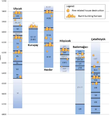
Figure 7. Incidence of fire-related house destruction in Central and Western Anatolia. Chronological chart adapted from Thissen (2010, fig.13).
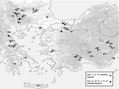
Figure 8. Distribution of selected Neolithic sites in Anatolia and Southeast Europe according to the maximum depth of stratified deposits.
Figure 9. Aşıklı; schematic section of the deep sounding in trenches 4 G-H. Building phases of Levels 2-3 (Esin and Harmankaya 1999, fig.9).
Figure 10. Lerna; diagrammatic section through Square E7 in area JA-JB, as seen from the east (Caskey 1957, fig.5).
Figure 11. Plan of Hacılar with the three main building-levels (Brami and Heyd 2011, fig.1). Figure 12. Quantitative distribution of Neolithic/Early Chalcolithic ‘burials’ in Anatolia and
Southeast Europe during the interval 8,500-5,500 BC cal.
Figure 13. Typical sequence of stratigraphic contexts associated with sub-floor burial. Figure 14. Typical sequence of stratigraphic contexts associated with in-fill burial.
Figure 15. Barcιn; adult skeleton in extreme ‘hocker’ position in an inter-dwelling space, Trench M13.
Figure 16. Geographical distribution of curvilinear and rectilinear forms of architecture in Anatolia and Southeast Europe during the interval 8,500-5,500 BC cal.
Figure 17. Floor plans of typical multi-roomed buildings from the Northern Levant.
Figure 18. Comparison scatter plot of interior dimensions of fully excavated rooms in selected Neolithic houses from Anatolia and Southeast Europe. Method and Çatalhöyük xy points after Düring (2006, fig.6.9).
Figure 19. Comparison scatter plot of number of rooms in building against minimum interior size of fully excavated rooms in Anatolia and Southeast Europe.
Figure 20. Çatalhöyük; ‘clean’ and ‘dirty’ areas of a typical main room. Text and line/shapes on an isometric drawing by Mellaart (1967, fig.11).
Figure 21. Floor plans of selected Neolithic houses in the Eastern Marmara region. Figure 22. Floor plans of selected Neolithic houses in Anatolia and Southeast Europe.
x
Figure 24. Radial lines and terraces in the northwest quadrant of Aşıklı (A) and the south area in Çatalhöyük VIB (B).
Figure 25. Courtyard-house complexes in Çatalhöyük, Level IV (A), Hacılar VI (B) and Hacılar IIA (C).
Figure 26. ‘Boundary’ settlements in Northwest Anatolia and Thrace: Aktopraklık B (A), Aşağı Pınar 6 (B) and Ilıpınar 6 (C).
Figure 27. 14C Backbone distribution of 848 calibrated radiocarbon intervals, at 2 standard deviations (95.4% probability), from 59 Neolithic and Early Chalcolithic sites in Central Anatolia (red), Western Anatolia (blue), Greece (orange) and Thrace (green) during the interval 9,000-5,500 BC cal.
Figure 28. Geographical distribution of important Epi-Palaeolithic/Mesolithic sites, known and potential aceramic Neolithic sites, in Anatolia and Southeast Europe.
Figure 29. 14C Backbone distribution of 230 calibrated radiocarbon intervals, at 2 standard deviations (95.4% probability), from Çatalhöyük East (red) and 9 Southwest Anatolian sites (blue): Bademağacı, Çukuriçi, Ege Gübre, Hacılar, Höyücek, Karain B, Kuruçay, Ulucak and Yeşilova, during the interval 9,000-5,500 BC cal.
Figure 30. 14C Backbone distribution of 188 calibrated radiocarbon intervals, at 2 standard deviations (95.4% probability), from 9 Southwest Anatolian sites (blue) and 7 Thessalian sites (orange): Achilleion, Argissa, Elateia, Otzaki, Platia Magoula Zarkou, Sesklo and Theopetra Cave, during the interval 9,000-5,500 BC cal.
Figure 31. 14C Backbone distribution of 222 calibrated radiocarbon intervals, at 2 standard deviations (95.4% probability), from Çatalhöyük East (red) and 5 Northwest Anatolian sites (blue): Aktopraklık, Barcın, Ilıpınar, Menteşe and Yarimburgaz Cave, during the interval 9,000-5,500 BC cal.
Figure 32. 14C Backbone distribution of 178 calibrated radiocarbon intervals, at 2 standard deviations (95.4% probability), from 5 Northwest Anatolian sites (blue) and 9 North Aegean and West Bulgarian sites (green): Dikili Tash, Dobrinište, Elešnica, Gălăbnik, Hoca Çeşme, Kovačevo, Kremenik, Makri, Uğurlu, during the interval 9,000-5,500 BC cal.
xi
List of Tables
All tables by the author, except where otherwise stated.
Table 1. List of similarities between the Hacılar and Sesklo cultures (Mellaart 1958, 154-156).
Table 2. Basic synchronisation of Anatolian and Southeast European Neolithic cultures. Table 3. Identification criteria for the practice of house infilling in the archaeological record. Table 4. Çatalhöyük; sequence of ‘closure’-related activities in Building 80.
Table 5. Identification criteria for the practice of house burning in the archaeological record. Table 6. Evidence for large-scale fire destructions in Central and Western Anatolia.
Table 7. Identification criteria for the practice of vertically superimposing houses in the archaeological record.
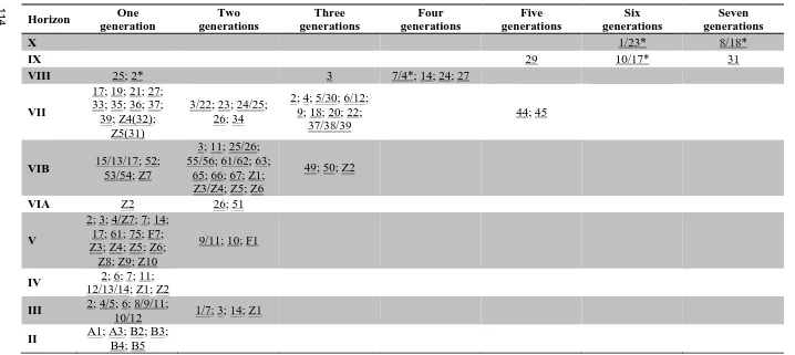
Table 8. Longevity of buildings in the South Excavation Area at Çatalhöyük, based on the number of generations buildings were renewed on the same foundations.
Table 9. Definition of recurrent features and immobilia encountered in the Neolithic period. Table 10. Time-range of ‘older’ residential and construction practices in Central Anatolia. Table 11. Time-range of ‘younger’ residential and construction practices in Central Anatolia. Table 12. Presence of the major cereal, pulse and animal domesticates in selected Neolithic
xiv
xv
Acknowledgements
My concern with the spread of the Neolithic from Anatolia to Europe began several years prior to commencing work on this thesis. It was only upon my transfer to the University of Liverpool in January 2011 that the methods to address this question became apparent. Meeting Douglas Baird, who introduced me to the world of practices, was a qualitative leap in my research development, and I am grateful to him for accepting me as one of his PhD students. My second supervisor, David Shankland, has supported me since the beginning of my undergraduate studies in archaeology. His influence on my academic career has been far greater than he would care to admit. John Gowlett has been a very important member of the supervisory team and I am grateful to him for taking on this role on my arrival in Liverpool. Finally, this work owes a lot to my initial supervisor, Volker Heyd, who sparked my interest in the ‘big picture’ and guided me through the first steps of this research. Those who were in Bristol in 2010 will remember that it was a difficult period for the Department and for the community of Clifton, where I was a resident. I thank Volker Heyd for his understanding at the time, and for staying in contact since.
xvi
me access to the Hacılar collection and to Adnan Gün for showing me the sites of Hacılar and Kuruçay.
I would like to express my deepest gratitude to my supervisors and to João Zilhão for sending me detailed comments and corrections on an earlier draft. Çiler Çilingiroğlu, Shahina Farid and Laurens Thissen kindly read and commented on sections of this thesis. I thank them for their constructive feedback and advice. Laura Haapio-Kirk was generous enough to proofread sections of the draft. Special thanks are due to Shahina Farid and Bernhard Weninger for sharing their articles with me in advance of print. I am grateful for helpful information and comments from (in alphabetical order): Mert Avcı, Ofer Bar-Yosef, Erhan Bıçakçı, Canan Çakırlar, Çiler Çilingiroğlu, Zafer Derin, Aylan Erkal, Ivan Gatsov, Fokke Gerritsen, Martin Godon, Harald Hauptmann, Barbara Horejs, Necmi Karul, David Orton, Mehmet Özdoğan, Jessica Pearson, Ulf Schoop, Heiner Schwarzberg, Laurens Thissen and Peter Tomkins. I thank Christina Papageorgopoulou for helpful information during my stay in Greece. Ivan Gatsov and Alexander Chohadzhiev helped me to plan my visit to Bulgaria. I am grateful to the British Institute at Ankara (BIAA), the Deutsches Archäologisches Institut in Istanbul (DAI), the Institut Français d’Études Anatoliennes (IFEA) and the Netherlands Institute in Turkey (NIT) for having me stay and use their facilities and collections.
I owe a great debt of gratitude to Joachim Burger for taking me onboard the Bridging the European and Anatolian Neolithic (BEAN) Project. It has been a rare privilege to be able to exchange at length with colleagues and friends of this network, particularly in the final stages of this research. I have fond memories of our trip to the Danube Gorges and to Western Anatolia and I look forward to more events of this sort in the future.
This project would not have been possible without the support of the National Research Fund, Luxembourg. I thank the two anonymous reviewers who accepted my proposal and supported my grant application.
1
Introduction
The Neolithic ‘Revolution’ arguably featured one of the first wholesale replacements of economic and social practices in the history of mankind.Not only did Neolithic farmers start to produce their own means of subsistence through cultivation and herding, but they invented a new set of interrelated practices, which transformed the way people performed activities in daily life. Some of these practices are still in evidence today: plant and animal domestication, land-clearance, transhumance, sedentism, nucleation, storage accumulation, and so forth.
The Neolithic pattern of existence evolved independently in different centres (Southwest Asia, sub-Saharan Africa, Southeast Asia, China, Meso- and Central America), from where it spread radially to other regions. Ever since Vere Gordon Childe’s work on The Dawn of European Civilization (Childe 1925), it has been widely accepted that European agriculture originated in Southwest Asia. Exactly how farming spread to Europe from its origins in Southwest Asia remains a matter of debate. This question provides a starting point for this research.
Over the years, much of the argument has revolved around the manners of spreading of Neolithic innovations, whether through colonisation, acculturation or a combination of both (e.g. Ammerman and Cavalli-Sforza 1984; Price 2000; Perlès 2001). Far less attention has been given to the actual content of the Neolithic pattern of existence that spread into Europe. Before one raises the prospect of finding out who Neolithic people were, where they came from or, critically, how and why they adopted farming, one would have to determine which innovations spread and which were lost, and whether innovations travelled together as part of one or more lifeways or ‘packages’. Consequently, this thesis is not only an attempt to answer the question raised above, but also a deliberate effort to adjust the frame of the question.
2
Schachermeyr 1976). In reality, objects served merely as chronological markers to synchronise prehistoric cultures and place them in a unified sequence. Scant attention was given to the broader context of understanding of these objects. Increasing realisation that two societies may share very similar sets of objects, and yet have different sets of meanings or rules attached to these objects and governing their use in everyday life, highlighted the inability of similarity-based approaches to tackle the heart of the problem, that is, to determine the content of the Neolithic pattern of existence that spread into Europe.
The idea behind this project is simple. If in place of similarities in material culture, one was to consider practices as the basic unit for our understanding of how farming spread to Europe, from its origins in the Near East, one would be able to develop a new approach that emphasises both the regional level of interaction and the context of action. For understanding how different societies go about doing things and tackling problems that arise from residence and construction has the potential to provide significant insight into the level of interaction between them.
Practice has come to acquire different meanings, whether one refers to the more general use of the term in everyday English language or to the academic tradition that stemmed from the writings of such influential social theorists as Pierre Bourdieu (1972[2000]) and Anthony Giddens (1984). These authors retained from the general definition of practice the idea that skills and knowledge are acquired through repetition of action. In their view, however, practice becomes a system of reproduction of society, which emphasizes the role of routinised daily action in shaping social agents’ prior experience of the world and in affecting the capability of these agents to influence social structures.
3 the social and structural interactions that take place in between societies, critically during key regional shifts such as the spread of agriculture, tend to be overlooked. By bringing together evidence drawn from a wide range of sites belonging to the same chronological horizon, c. 8,500-5,500 BC cal., in Anatolia and Southeast Europe, it becomes possible not only to study practices, but also the diffusion of practices.
For this approach to be viable, it is necessary to focus on those practices that have a material expression, and which can be reconstructed from the most readily available type of context in Anatolia and Southeast Europe, that is, Neolithic houses. The practices which form the basis of this study are intermittent practices relating to the house and thus to one of the core expectations of the Neolithic pattern of existence, sedentism. What is at issue here is not the house per se, but how social practices associated with the house developed in both time and space. In mediating the interaction between the small-scale context generated through archaeological excavations and the regional context drawn from compiling together evidence from a range of archaeological sites, practices provide an analytical framework to address the bigger picture, namely the diffusion of the Neolithic as a lifeway, a habitus of practices, from Anatolia to Europe.
The first three chapters provide the general framework of the project. Chapter 1 sets the scene by returning to the overarching definition of the Neolithic and highlights the chronological lag between Central and Western Anatolia at the onset of the Neolithic. Chapter 2 lays out the history of the research question and introduces current approaches of the spread of the Neolithic into Europe. Chapter 3 draws from theories of social action to outline a method based on practices and shows how the context may be used to collect practices from their material expression.
4
inside the residential environment. If newer houses were always built in relation to pre-existing ones, they also conformed to a standardised layout, which was repeated from Anatolia to Europe. The implication is that houses from this period were lived-in in much the same way. While individual houses rarely consisted of more than one large room, in which people and activities clustered, the village as a whole often appeared as an orderly arrangement of agglutinated houses. Each of the five main chapters analyses changes in practice over time and tracks the diffusion of practices from Anatolia to Europe.
5
1
A Fast-Tracked Revolution?
The Neolithic Transition in Europe as Seen from the East
This chapter sets out the problem to be investigated and its significance for archaeology. Chronology underscores a two-thousand year lag, plus or minus a few hundred years, between the advent of Neolithic economy on the Central Anatolian Plateau and in the Aegean Basin. As it stands, the Western Anatolian Neolithic, which starts at or shortly before 6,500 BC cal., matches the Southeast European sequence more than it does the Southwest Asian one. This is merely an inference drawn from compiling a large database of radiocarbon dates and it may or may not reflect an objective reality. But wherever one places the threshold between these two chronological horizons, one is confronted with a huge gap, which has not received proper examination in the literature (Schoop 2005a; Düring 2013).
Before one can address the delayed adoption of Neolithic practices in Europe, one has to clarify what exactly is understood by the concept of Neolithic and why one must conceptualise it as diffusion rather than wholesale invention in this particular context of research. Returning to the overarching definition of the Neolithic, I use traditional markers of the Neolithic as identified by Vere Gordon Childe (1936), to highlight a contrast between a developmental Neolithic (an incipient revolution?) in the centre and the east of Anatolia and a fully-fledged, albeit later, Neolithic in Western Anatolia and into Europe. I suggest that the Neolithic transition in Europe was ‘fast-tracked’ under the impulse of the Neolithic revolution in Southwest Asia.
1.1 The Neolithic: a changing definition
6
to be a gross understatement (Pollard 2002, 5). At the same time, one cannot formally discount that Neolithic communities were self-consciously involved in spreading the new pattern of existence (Cauvin 1994). In our attempt to strike the right balance between relative and essential views of the Neolithic (see Pluciennik 1998; Zvelebil and Lillie 2000; Thomas 2003), we are drawn towards the second type of views, and to the hypothesis that the Neolithic, as a lifeway or a ‘package’ of innovations, spread into Europe. By way of consequence, we can actually trace its concrete course of expansion across the Anatolian and European landmasses.
1.1.1 The Neolithic stage of culture
The adjective neolithic was coined by John Lubbock1 (1865[1869]) at the time when Charles Darwin published On the Origin of Species (Darwin 1859) and Charles Lyell established the antiquity of man in geology (Lyell 1863). Incidentally, the Neolithic, which literally means ‘new stone age’, was as much an element of classification or subdivision within the Three Age System devised by Christian Jürgensen Thomsen (1836), as an evolutionary stage in the history of human societies; for instance, the Neolithic coincided with a shift from savagery to barbarism in the scheme of Lewis Henry Morgan (Morgan 1877). What set the Neolithic apart from the Palaeolithic period was the introduction of polished stone implements (Lubbock 1869, 74). Technology was thus central to the original definition of the concept, although it was not its sole attribute.
There was an assumption that a settled life was a desirable step on the path to civilisation (Sherratt 2005): “[l]eading a more settled life, [the Neolithic man] buil[t] for himself a dwelling...” (Westropp 1872, 105). Given that Neolithic societies had achieved a higher level of social complexity, they were, almost by definition, sedentary, according to the first generation of social evolutionists. The legacy of Hodder Westropp in defining the first set of Neolithic traits has been recently
1 “The later or polished Stone Age; a period characterized by beautiful weapons and
7 highlighted (see Orton 2008, 3). Westropp observed that pit- and lake-dwellings, pottery, spinning implements, tumuli and domestic animals, such as the dog, the horse, the pig, the sheep, the goat and the short-horned ox, were all innovations of the Neolithic period (Westropp 1872, 105-106). The same year, Gabriel de Mortillet (1872) offered a roughly similar description of the ‘Robenhausian’ culture of Western Europe, giving more emphasis, however, to the role of agriculture and megalithic monuments (see Pluciennik 1998, 62).
1.1.2 Food-gatherers and food-producers
If the evolutionary framework, implicit in the above definition of the Neolithic, entailed a spatial division of societies at different levels of economic and social advantages (i.e. Neolithic by opposition with Mesolithic), the structural interaction between these societies during key regional shifts remained undertheorised. A prevalent theory in the second half of the 19th Century was that of a “psychic unity of mankind” (Bastian 1860) – the idea, namely, that the human mind was formed in such a way that it evolved innovations spontaneously, whenever they were brought to its attention (see Boas 1896[1940], 270; 1911[1938], 194). Diffusionism offered a challenge to this doctrine. In particular, the first generation of diffusionists competed in the search for the ultimate source of innovations and set out to identify, wherever possible, the influence of ‘higher civilisations’ on their neighbours (e.g. Elliot Smith 1915[1929]; Perry 1923; see also Champion 2003).
8
spread the cult of the Egyptian Sun-God and, alongside it, irrigation and agriculture (Elliot Smith 1933, 208). According to Elliot Smith, Neolithic stone implements found in Northwest Europe were imitations of metal tools and the megaliths mere copies of the great monuments of Egypt, reflecting the adoption of the same religion in this part of the world (Elliot Smith 1930, 103; 1933, 210).
It is not difficult to see the shortcomings of this theory, particularly in regard to the erroneous chronology (see, for instance, Renfrew 1973a). The concept of diffusion itself was challenged in social anthropology as early as 1927 by Bronislaw Malinowski, a founding father of the Functionalist school of thought, who easily refuted Grafton Elliot Smith’s bold assertions about the single origin of culture2
(Elliot Smith 1927) and proposed instead a more nuanced, though, arguably, equally problematic, explanation of culture change, involving adaptation or “re-evolution”3 (Malinowski 1927). There are good reasons, however, for re-examining the legacy of Grafton Elliot Smith in light of what came after him: Elliot Smith was first to establish a coherent, though incorrect, narrative for the Neolithic transition, emphasising the functional relatedness of the different components of the Neolithic pattern of existence (Elliot Smith 1930). In particular, Elliot Smith stressed the centrality of economy by drawing a distinction, which has still currency today, between “food-gatherers”, who lived at the expense of nature, and “food-producers”, who created their own means of subsistence (Elliot Smith 1930, 197). Like Childe, Elliot Smith was born and raised in Australia; and there can be no doubt that both authors shared similar mindsets, inherited from their experience of a continent, which, until 1788 AD – the date at which the first British colonies were established – was occupied mainly by nomadic hunter-gatherers, who did not practise agriculture, ceramic or metal-working (Laming-Emperaire 1966, 204). As purported by Elliot Smith (1930, 197): “The food-gatherers
2 “We know in the case of every modern invention, that it was made in one definite place and
became diffused over a wider and wider area until everyone in any part of the world who is making use of this particular invention is indebted directly or indirectly to one man in one particular place who was originally responsible for initiating the process” (Smith 1927, 10).
3 “Just because no idea and no object can exist in isolation from its cultural context, it is
9 live[d] mainly on the outskirts of the world, far from the great centre of civilization. In some cases they occup[ied] countries, such as Australia […]”.
1.1.3 The Neolithic ‘Revolution’
Vere Gordon Childe amalgamated some of these theories into a holistic narrative, which remains to this day: from Evolutionism, he drew the notion of progress4 and, from Diffusionism, the spatial division between food-gatherers and food-producers5 (McNairn 1980, 4-45); in addition, Childe derived from his own political background, Marxism, an interest in the means of production and in revolution, as a cumulative process with a point of no return. Childe articulated a model revolving around the shift to food production, which he made the unifying principle for defining Neolithic societies (Childe 1951, 22): “The first revolution that transformed human economy gave man control over his own food supply” (Childe 1936, 74-75).
In Childe’s view, the ramifications were immense. A symbiotic relationship was established between humans, some plants and animals, and the latter two became dependent on man for their breeding or subsistence (Childe 1936, 74-75). The achievement of sustainable food production was in turn a necessary precondition for population increase (Childe 1936, 78). As populations grew, agriculturalists were faced with problems that necessitated collective effort and the development of new apparati. One such entanglement was the storage of surplus, which was remedied by adopting ceramic vessels that would at once hold foods and stand heat (Childe 1936, 101). Artefacts from this period acquired new meanings, which transcended their primary definition. To clear forest and open up arable farmland, Neolithic societies
4 “If stages of economic and social evolution are to be defined on technological bases,
food-production should surely mark the beginning of a major stage. I propose therefore to use it to define the transition from Savagery to Barbarism, and so far to allow Barbarism and Neolithic to coincide” (Childe 1951, 22-23).
5 “So in 1925, adopting an idea advanced by Elliot Smith ten years earlier, from the three
10
used stone axes, which were finely ground down to form a sharp cutting edge; other groundstone tools served to process crops and wild cereals (Childe 1936, 99). The advanced knowledge of plant and animal species afforded to Neolithic populations led to a shift in consumer habits. Domesticates were increasingly used for their secondary products (Childe 1936, 89). The Neolithic witnessed, for instance, a surge in the development of textile and textile-related products, as shown by the presence of loom weights and spinning implements (spindle whorls) in Neolithic assemblages (Childe 1936, 106).
Vere Gordon Childe’s model ran against common views of the Neolithic as a shift to settled life, because sedentism was not directly consequent upon the adoption of food production economy. On the contrary, he suggested that the problem of soil exhaustion in primitive hoe agriculture was dealt with by occasional settlement relocation, while pastoral economy implied a nearly nomadic lifestyle (Childe 1936, 82; 91). This also proved a point against the supposed isolation of Neolithic societies, which were involved in ever more complex and long-distance exchange networks (Childe 1936, 98). Childe’s ‘revolution’ was both a cumulative process with a point of no return – an “entanglement” in the modern sense (see Hodder 2011; 2012) – and a historical process happening in space and time (Childe 1936, 74). Constituent components of the Neolithic were functionally related and contingent upon the invention of food production economy, which, for environmental and cultural reasons, had happened only once, within the Near Eastern ‘heartland’ of domestication. Childe did not, however, conceive the various items that make up the Neolithic as integral components of a fast-spreading ‘package’ – there is no indication, for instance, that Neolithic items appeared, nor even travelled together in his writings – but instead they appeared as “mutually reinforcing parts of an unfolding process” (Zeder 2009, 39; see also Reingruber 2011b, 293).
1.1.4 More than one Neolithic?
11 more criteria of the Neolithic lifeway receive greater relative weighting and come to determine the whole system of change (Tringham 2000a, 22). Perhaps the best-known example is Ian Hodder’s The Domestication of Europe, which emphasises the conceptual opposition between the domus and the agrios as being central to the revolution that brought about, among other things, the domestication of plants and animals (Hodder 1990). The domus refers to the emergence of the house, as both a physical and conceptual framework, to control the wild or savage contained within the agrios (Hodder 1990). At the most basic level, Hodder’s “domestication” may be seen as an attempt to replace one criterion (economic food production) by another one (the symbolic taming of the wild), to characterise the Neolithic phenomenon in its entirety. Like Childe’s economic ‘revolution’, Hodder’s ‘revolution of symbols’ thus assumes a distinction between criteria that are essential for the existence of the Neolithic and criteria that are simply derived and non-essential, such as food production in this instance (Hodder 1990, 31).
12
The concept of the Neolithic ‘package’6
enables a synthetic understanding of the Neolithic “without isolating or overemphasising some of the find groups” (Çilingiroğlu 2005, 2-3). It assumes a view of the Neolithic as a network of functionally related traits that evolve and subsequently travel together. Çiler Çilingiroğlu, for instance, outlines a suite of 21 elements, including figurines, ceramic wares, objects of personal adornment, tools, weapons, and small finds of indiscriminate function, which occur repeatedly within Early Neolithic assemblages from the Near East to Europe (Çilingiroğlu 2005). Although Çilingiroğlu succeeds in showing the existence of a ‘package’, which she defines from the ground up, it is not clear how it relates to the spread of the Neolithic in the first instance. Her model remains culture-specific and does not apply to, say, the Neolithic of Britain. A unifying principle that would link up all of the aforementioned elements according to a principle of causal dependence – A is a condition of B – is lacking. On the other hand, if the Neolithic is a truly polythetic category, not all of these elements are required at one time, at one place. When used in the plural form, the concept of Neolithic ‘packages’ opens up the possibility that there may be more than one expression of the same ‘essential’ Neolithic. Mehmet Özdoğan shows, for instance, how a core Neolithic expectation (settled village life) translates into a number of practical solutions (timber versus mud-built architecture for instance), which relate to the spread of two or more ‘packages’ of Neolithic innovations through Anatolia and across Southeast Europe (Özdoğan M. 2011a, S427).
In sum, what has been established so far is that the content of the Neolithic takes structural precedence over its manners of spreading. The Neolithic in most literature is associated with a suite of traits, including – but not restricted to – food production, settled village life, a revolution of symbols, polished stone tools and pottery (in this or another order). The successful spread of the Neolithic across Europe may be attributable precisely to its particular structure, as an integrated ‘package’ of functionally related traits, where none can exist separately. The unifying principle that underlies the Neolithic ‘revolution’ remains unclear. Vere Gordon Childe’s model
6
13 perhaps retains authority on the subject matter, given that what stays constant through time – from the Near East to the British Isles – is the ‘package’ of economic domesticates7 (wheat, barley, cattle, sheep, goats, pigs) and associated subsistence strategies. The model of shifting cultivation proposed by Childe, in which new arable plots were opened up by clearing woodland, while old plots lay fallow for a period of several years, may explain why agriculture was expansive and had both a cyclical and a wave dynamics (see Bogaard 2004a, 21; 51; Ammerman and Cavalli-Sforza 1984). Shifting or slash-and-burn cultivation comes under intense scrutiny, however, due to the small-scale and intensity in which farming seems to have been practised in the Anatolian, Southeast European and Central European Neolithics (e.g. Halstead 1987; 1996a; 1996b, 302-304; Halstead and Isaakidou 2013, 133; Bogaard 2004a, 154; 2004b; Fairbairn 2005, 198; Sherratt 2007). Amy Bogaard suggests instead a model of “intensive garden cultivation”, in which cultivated plots were potentially maintained and used for hundreds of years, through the continuous replacement of soil nutrients by manuring and middening (Bogaard 2004a, 161). Long-term investment in a fixed plot of land removed the incentive for settling elsewhere, suggesting that “the spread of farming took place despite the intensive nature of crop and animal husbandry” (Bogaard 2004a, 162). Although this model does not challenge the importance of agriculture to Neolithic societies, questions arise as to what was the driving force behind the expansion of agriculture in Europe.
1.2 The two Neolithics of Anatolia
The context in which this study was undertaken follows naturally from the preceding discussion. Turkey sits astride two continents, Asia and Europe, and this ambivalence is reflected in the archaeological fault line between a ‘developmental’ Neolithic, which was remarkably old, to the centre and the east where Asia begins, and a ‘fully-fledged’ – albeit later – Neolithic on the north and west fringes, along the
7 A gradual loss of diversity of cultivated crops from Southeast to Northwest Europe has been
14
main routes that led to Europe. Consequently, the Neolithic of Anatolia may be conceptualised as a microcosm of the Neolithic world, which was divided between ‘zones’ of primary neolithisation and zones of ‘secondary’ neolithisation (Cauvin 1994, 4).
‘Primary’ neolithisation refers here to the formative process by which the Neolithic pattern of existence (the ‘package’?) evolved in a few centres of food-plant and animal domestication. Typically, a period of “stasis” is expected between the first introduction of domesticates and the adoption of a self-sustaining farming economy in zones of ‘primary’ neolithisation (Perlès 2003a, 102). ‘Secondary’ neolithisation, by contrast, refers to the derivative process of ‘diffusion’ of the (fully-formed) Neolithic pattern of existence in regions previously unrelated. A caveat must be drawn immediately: the core-periphery framework implicit to the aforementioned division assumes chronological precedence of Southwest Asia vis-à-vis Europe; it does not imply that the European Neolithic was (exclusively) Southwest Asian in character, nor that there was no diffusion inside ‘primary’ centres of neolithisation.
1.2.1 Anatolia, a land of two continents
15 Anatolia is the only east-west oriented peninsula (of any significant size) in the Mediterranean basin; a configuration, which, throughout history, has contributed to the flow of men and ideas between Europe and Asia. Despite mountains, such as the Taurus Range, and high plateaus making up most of the Anatolian landmass, Anatolia was never an environmental barrier per se. Altitude rises gently and by degrees. Prominent volcanoes and snow-covered mountains, such as the Hasandağ, Erciyes Dağ and Uludağ, are visible from afar and serve as landmarks for people who travel across the plateau (Mellaart 1964a, 5). In addition, great natural routes along the Büyük Menderes (Classical Maeander) and the Gediz (Hermus) river valleys link up the Central Anatolian Plateau with the Aegean coast of Turkey (Mellaart 1964a, 4). Today, the location of these routes is signalled by major regional roads and motorways.
But the Aegean Sea does not constitute a barrier either. From Çesme, one can reach the Greek mainland via a chain of intervisible islands, including Chios, Psara, Skyros and the Sporades. Further south, the Cyclades provide a myriad of alternative routes. The recovery of Neolithic and possibly Pre-Neolithic finds on the islands of Crete and Cyprus establishes the feasibility of such movements across water in prehistoric times (Broodbank and Strasser 1991; Broodbank 2006; Strasser et al. 2010). Prehistoric findspots on smaller Aegean islands are conspicuously scarce but not absent8. Early Neolithic farmers displayed a clear preference for sedimentary basins, such as the Plain of Larissa in Thessaly, and may have neglected other environments (van Andel and Runnels 1995; Andreou et al. 1996). Southern Greece was apparently less densely settled, due to its environmental setting (Alram-Stern 2005, 186; Johnson 1996, 258; Perlès 2001, 118; but see Cavanagh 2004, 180), and settlements were located on the coast rather than in the enclosed valleys (Talalay 1993, 59). Some degree of interaction between Mesolithic and Neolithic communities in this region cannot be ruled out (see, in particular, Perlès 1990, 136).
8
e.g. Agio Gala on Chios (Hood 1981); Agios Petros on Kyra Panagia (Efstratiou 1985; Theocharis 1973, 57); Aspri Petra on Kos (Erdoğu 2003, n.2:20); Cyclops on Youra (Sampson 1998, 4; 21; 1996-1998, 94; 2006); Kalythies on Rhodes (Erdoğu 2003, n.2:20); Maroulas on Kythnos (Honea 1975; Sampson 2006; 2008; 2010); Ouriakos on Limnos (Efstratiou et al.
16
The Anatolian Peninsula is also connected to Thrace via the Strait of Çanakkale (formerly known as the Dardanelles) and the Bosphorus, which, although difficult to cross due to strong currents, were never insurmountable obstacles (but see Takarova 2011). Likewise, there is no physical boundary between Turkish Thrace and Bulgaria, if one excepts the low-lying Strandzha range to the east of the present border. Incidentally, the site of Aşağı Pınar near the Turkish city of Kırklarelı is currently being investigated as a typical Karanovo site by researchers from the University of Istanbul (Özdoğan M. 2011b, 83-84). The Thracian Plain, which includes the catchment area of the Maritza (Evros) river and of two of its tributaries, the Tunja and the Arda (Nikolov 2007, 7), is bounded to the north by the Balkan range (Stara Planina), which stands as a geographical and climatic barrier between the north and the south of the Balkan Peninsula (Takorova 2011, 3).
The deep valleys of the Struma (Strymon) and the Mesta (Nestos) rivers, which are separated from the Thracian Plain by the Rhodope Mountains, provide another gateway to the Balkan hinterland. Both rivers are characterised by much narrower catchment areas as well as a distinctive Mediterranean climate with higher rainfalls (Popova and Marinova 2007, 500). Like the Maritza River further east, both the Struma and the Mesta rivers discharge their water in the Aegean basin. The Struma valley also provides direct access to both Greek and Yugoslav Macedonia. West of this valley rise the Malesevski and the Osogovski ranges. The Kresna Gorge, which divides up the course of the Struma River apparently also provided a boundary between different cultural spheres in the Neolithic (Lichardus-Itten et al. 2006, 83).
17 delayed the advent of settled life and agriculture in Western Anatolia and consecrated the plateau’s isolation.
1.2.2 The two thousand year lag: introducing the 14C Backbone
In spite of the fact that there are no physical boundaries in the study region, evidence drawn from chronology suggests that the westward spread of Neolithic economies was a punctuated process in fits and starts (for discussion, see §9.1). The 14
18
Figure 1. Geographical distribution of 59 radiocarbon-dated Neolithic sites in Anatolia and Southeast Europe.The sites are divided up in four regional groups according to their colour code in the 14C Backbone interface: Central Anatolia (red), Western Anatolia (blue), Greece (orange) and Thrace (green). 2. Achilleion; 4. Agios Petros; 6. Aktopraklık; 7. Argissa; 8. Aşağı Pınar; 9. Aşıklı Höyük; 11. Azmak; 12. Bademağacı; 14. Barcın Höyük; 18. Can Hasan I/III; 19. Çatalhöyük East/West; 20. Čavdar; 24. Çukuriçi Höyük; 25. Cyclops Cave; 29. Dobrinište; 31. Ege Gübre; 32. Elateia; 33. Elešnica; 34. Erbaba; 36. Franchthi; 37. Gălăbnik; 40. Hacılar; 41. Halai; 43. Hoca Çeşme; 44. Höyücek; 46. Ilıpınar; 48. Kaletepe; 50. Karain Cave; 51. Karanovo; 53. Kazanlăk; 54. Knossos; 56. Kovačevo; 58. Kremenik; 60. Kuruçay; 62. Makri; 63. Maroulas 64. Menteşe Höyük; 65. Mersin-Yumuktepe; 67. Musular; 69. Nea Nikomedeia; 71. Otzaki Magoula; 74. Pınarbaşı; 76. Platia Magoula Zarkou; 81. Servia; 82. Sesklo; 83. Sofia-Slatina; 85. Stara Zagora – Okražna Bolnica; 86. Suberde; 87. Tepecik-Çiftlik; 88. Theopetra Cave; 91. Uğurlu; 92. Ulucak Höyük; 94. Yarimburgaz Cave; 95. Yeşilova Höyük. For a full list of sites, see Appendix E.
One advantage of this display is that it does not pre-judge the quality of the dates, which are simply placed side by side in the excel diagram with a secure confidence margin of two standard deviations (95.4% probability9). The dates are arranged in chronological order from the oldest to the youngest date BP and are given one of four colour codes, corresponding to Central Anatolia (red), Western Anatolia
9
[image:34.595.86.473.110.394.2]19 (blue), Greece (orange) and Thrace (green). The division into four broad regions and colours is arbitrary and has been adopted for the sake of clarity and to enhance the visual output. The user may decide to change this grouping by checking or unchecking selected sites or regions in the interface (CD-ROM). Although the distribution of calibrated intervals instantly flags out isolated dates or statistical outliers, which appear either too old or too young in the diagram, the appraisal is not complete without a quality assessment of the database as a whole and of the suitability of each date taken individually (Zilhão 2001; Brami and Heyd 2011).
The bulk of calibrated dates from Greece, which were processed between the 1950s and the 1970s, is characterised by large standard deviations comprising between 200 and 400 calibrated years at 2σ. In contrast, the majority of dates from Western Anatolia, which were processed over the last two decades, present smaller intervals of between 100 and 200 calibrated years (Brami and Heyd 2011, 173). It follows that, placed side by side in the 14C Backbone, dates from the Greek side appear anomalously old; that is, if one only considers the endpoint, and not the complete interval. Another bias to take into account is that all regions did not contribute equal amount of radiocarbon dates to the database. Within the interval 9000-5500 BC cal., Central Anatolia contributed 310 dates, Western Anatolia 182, Greece 172 and Thrace 184. The distribution is skewed towards recognition of bigger sites, such as Çatalhöyük, Ilıpınar and Aşıklı, which produced over 50 dates each.
The majority of dates listed in the 14C Backbone stem from charcoal samples10, rather than samples of grains and/or bones of domesticates. Thus, they do not date the advent of Neolithic economy itself, only building-phases or levels ascribed to the ‘Neolithic’ by the excavators. Cave sites, which occasionally span Mesolithic and Neolithic occupations, should be treated with caution. For instance, the
10 There are inherent problems associated with charcoal samples, which limit their reliability.
20
series of dates from Theopetra Cave in Thessaly, although reliable on principle, raises questions about the stratigraphy of the cave (see Facorellis et al. 2001, 1040; 1044; Manolis and Stravopodi 2003). There is a chronological gap between two series of dates, one clustering at ~7,000 BC cal. (CAMS-21773; 576; 583; DEM-360; DEM-918) and the other at ~6,300 BC cal. (DEM-919; DEM-917). The suggestion is that the earlier series relates in fact to a later Mesolithic horizon. This result awaits confirmation by dating of the domesticates themselves. On the other hand, none of the open-air sites in the study region demonstrates such a continuity between Mesolithic and Neolithic occupations, and it is safe to assume that they were all ‘Neolithic’ from the start.
21
[image:37.842.74.776.160.474.2]
Figure 2. 14C Backbone distribution of 492 calibrated radiocarbon intervals, at 2 standard deviations (95.4% probability), from 12 sites in Central Anatolia (red) and 14 sites in Western Anatolia (blue) during the interval 9,000-5,500 BC cal. The dates were re-calibrated using the IntCal09 atmospheric curve (Reimer et al. 2009) in OxCal 4.2 (Bronk Ramsey 2013). The intervals are ranked in chronological order from the oldest to the youngest date BP.
9000 8500 8000 7500 7000 6500 6000 5500
C
al
ibr
at
e
d
Y
e
ar
s
B
22
9000 8500 8000 7500 7000 6500 6000 5500
C
al
ibr
at
e
d
Y
e
ar
s
B
[image:38.842.59.772.114.435.2]C
23
1.2.3 A fault-line between Central and Western Anatolia
In this section, I use some of the traditional markers of the Neolithic as identified by Vere Gordon Childe and others to characterise the Neolithic phenomenon in two regions of Anatolia: food production, as indicated by the introduction of plant and animal domesticates, settled village life, ground stone tools, pottery and weaving implements. A full analysis would require one to put each and every one component of the Neolithic way of life into broader historical context, which is beyond the scope of this introduction (see Zeder 2009). It is enough, for now, to highlight the ‘tip of the iceberg’, namely the pregnant contrast between Central and Western Anatolia regarding the advent of Neolithic innovations.
1.2.3.1 Central Anatolia
In Central Anatolia, the various elements that make up the Neolithic pattern of existence did not emerge concomitantly, but one after the other over a period of two thousand years.
Domestic Food Plants. The first evidence for the appearance of domestic food-plants in Central Anatolia seems to be at Boncuklu in the Konya Plain and at Aşıklı in Cappadocia. Certainly, by about 8,300 BC cal., morphologically domestic cereals, including wheat and barley, are found in Central Anatolia (Baird 2012b, 440; Asouti and Fairbairn 2002, Table 1). The botanical assemblage at Boncuklu includes Neolithic founder crops, such as emmer wheat, possibly einkorn, hulled barley and an archaic form of free-threshing wheat (Baird et al. 2012, 230). Alongside crops, wild plant species, especially wetland taxa, were exploited for food (Baird et al. 2012, 230).
24
such as Aşıklı in Cappadocia and Çatalhöyük in the Konya Plain, have yielded the most complete package of crops (Asouti and Fairbairn 2002, Table 1). It has been observed that domestic wheat and barley probably had no wild ancestors in the Konya Plain and therefore that they were probably introduced in the region from the southeast (Asouti and Fairbairn 2002, 189; Colledge et al. 2004, fig.5; Baird et al. 2012, 232).
Domestic Animals. A proto-domestication of sheep and goats, based on the large number of perinatal bones, has been proposed at Aşıklı (Buitenhuis 1997, 659; see also, Martin et al 2002, 195; Pearson et al. 2007). At Boncuklu, by contrast, there seems to be a marked preference for hunting wild cattle and wild boars (Baird et al. 2012, 232). The first unambiguous evidence for domestic animals in the record dates to after c. 7,400 BC cal., when large numbers of domestic sheep suddenly appear in the basal levels of Çatalhöyük and at Suberde, together with evidence of selective culling (Arbuckle 2008a, 219; Arbuckle et al. 2009; Zeder 2011, S227; Baird 2012b, 440; but see Peters et al. 2013, 92; 97; 107). These animals seem to have been primarily exploited for meat.
25
Settled Village Life. The emergence of sedentary or, for that matter, “sedentarising” behaviour (Baird 2012a, 182; 2012b, 438) on the Anatolian Plateau, marked out by significant investment in domestic facilities, repeated use of a particular locale over time, year-round occupation or, at least, multi-seasonal occupation, has been traced back to the first half of the 9th millennium BC cal. (Baird 2012b, 438). Stratified exposures on the small promontory at Pınarbaşı in the Konya Plain have revealed a sequence of occupation at least 80 cm deep, consisting of curvilinear, semi-subterranean structures with plastered floors and plastered interior walls (Baird 2012a, 193-194). The floors and walls were re-plastered at intervals – up to seven times in Building 3 (Area D) – and were occasionally covered in red ochre (Baird 2012a, 193). Remarkably, Building 3 cut into an earlier structure with a red floor, which suggests repeated use of the same plots for construction (Baird 2012a,193). Collapsed material recovered within the fill of these buildings suggests that they were initially covered with a wattle-and-daub superstructure (Baird 2012a, 193). Building 5 in Trench A was provided with a hearth area, located towards the centre of the structure, as well as what appears to be a work surface, a shallow plaster basin and a small pit (Baird 2012a, 193). The occupation of this area of the site was radiocarbon dated to the 9th and early 8th millennia BC cal., which makes Pınarbaşı contemporary with Early PPNB sites in the Northern Levant (Baird 2012a, 197; 2012b, 438).
26
to the south (Baird et al. 2012, 234; see Hodder and Cessford 2004; Hodder 2006). Further to the east, in Cappadocia, one observes a shift from sub-circular to rectilinear forms of architecture in the basal sequence of Aşıklı (Özbaşaran 2012; Baird 2012a, 197). This coincides with the adoption of a cellular house pattern, consisting of densely clustered neighbourhoods of houses accessed through the roof by means of a ladder, of which a more elaborate form can be seen at Çatalhöyük (Hodder 2006; Düring 2006). By 7,000 BC cal., large agglutinated villages have become the standard settlement form in this part of Anatolia.
Ground Stone tools. If ground stone tools are conspicuous by their rarity in the lower levels of the rockshelter at Pınarbaşı (B), dated to the later Epi-Palaeolithic on the basis of lunates and other microliths with parallels with the Natufian in the Levant, they occur in great frequency in the subsequent 9th millennium open-air site at Pınarbaşı (Baird 2012a, 185; 187-188; 195). Some of the ground stones, such as querns, handstones and heavy duty pestles, which could be used in combination with bedrock mortars, were evidently used to process nuts, which were gathered in significant number at the site (Baird 2012a, 195). In addition, greenstone axes, which show evidence of reworking, might have been exchanged and curated (Baird 2012a, 195).
mineral-27 tempered vessels took over the role of cooking from the clay balls at Çatalhöyük after Level VII, c. 6,600 BC cal. (Hodder 2006, 53; Yalman 2006, 37-38).
A further development in pottery production seems to have been the introduction of red-slipped burnished wares on the Central Anatolian Plateau, characterised by mineral inclusions and a slip in shades ranging from yellow to red (Godon 2008). The fine, lustruously burnished vessels, with little trace of secondary burning (Özdoğan 2006a, 26), perhaps served a different function as storing and serving vessels. Earlier examples of red-slipped burnished pots decorated with elaborate appliqué scenes representing both domestic and wild animals, as well as human figures involved in everyday activities, were recovered at Köşk and Tepecik Çiftlik in Cappadocia (Godon 2008, 444). Red-slipped sherds are then encountered in Level V at Çatalhöyük, c. 6,400 BC cal. (Last 2005). Occasionally they were painted red, and this form of decoration became widespread by the time of the Çatalhöyük West occupation (Çilingiroğlu 2009c).
Weaving. The dating of the first appearance of weaving practices on the Central Anatolian Plateau relies in part on our interpretation of the stamp seals – also known as pintaderas – as cloth markers. Çiler Çilingiroğlu made a convincing case for such an interpretation on the basis of contextual evidence from the chronologically-overlapping site of Ulucak in Aegean Anatolia (Çilingiroğlu 2009b, 5). Earlier pintaderas at Çatalhöyük stem from Level VII and can be dated to no earlier than c. 6,600 BC cal. (Lichter 2005b, 69; Hodder 2006, 233).Another strand of evidence is flax cultivation, which has been documented at Çatalhöyük East (see Düring 2011, 198). Recently, a finely woven linen cloth, made from flax, was recovered in one of the sub-floor burials of Building 52 in the 4040 area; the cloth was inadvertently preserved when the building was set on fire (Hodder 2013a, 24).
1.2.3.2 Western Anatolia
28
Domestic Food Plants. Preliminary study on the plant remains in the basal level of Ulucak, Level VI, dated to c. 7,000-6,500 BC cal., indicates that the first settlers cultivated einkorn and emmer wheat, barley, durum wheat, free-threshing wheat and lentil (Çilingiroğlu et al. 2012; Erkal, personal communication). There were few wild species; changes over time pertained more to the proportion of specific cereal and pulse species than to the composition of the archaeobotanical assemblage itself (Erkal, personal communication).
Domestic Animals. Similarly to the pattern observed for plants, morphologically domestic species dominated the archaeozoological assemblage at Ulucak, Level VI. The fact that all four domestic animal taxa were present from the start of the sequence at Ulucak suggests the transplantation of an artificial agricultural system initially unreliant, or less reliant, on wild resources (Çakırlar 2012a; 2012b; Çilingiroğlu and Çakırlar 2013). This pattern stands in remarkable contrast with that observed on the Central Anatolian Plateau, where cattle and pigs are unlikely to have been domesticated until late in the sequence (Arbuckle 2013). Interestingly, domestic pigs were scarce or altogether absent in the Eastern Marmara region (Çakırlar 2012b, 88). Wild boars occasionaly occurred at Barcın with butchering marks (Gerritsen, personal communication). The four-tiered animal husbandry system evidenced at Ulucak has so far been identified at only one other site in Western Anatolia: Bademağacı, Levels EN I/7-EN II, after c. 6,700 BC cal. (De Cupere et al. 2008, 385; Çakırlar 2012b, 88). To add to the complexity, a recent study of mitochondrial DNA of pigs suggests that Western Anatolian pigs had different haplotypes than Near Eastern ones (Ottoni et al. 2013). In sum, although it is clear that food-producing economies and the main domestic species were introduced exogeneously into Western Anatolia after c. 7,000 BC cal., it is still difficult to pinpoint where they came from exactly. A single origin would appear to be unlikely in view of the regional diversity between Northwest and Southwest Anatolia.
29 Höyücek), the Aegean Coast of Anatolia (Ulucak, Yeşilova, Ege Gübre, Çukuriçi) and the Eastern Marmara region (Fikirtepe, Pendik, Ilıpınar, Barcın, Menteşe, Aktopraklık). There may be evidence for earlier Neolithic occupation at Hacılar, based on one conspicuously old radiocarbon date (BM-127: 8700±180 BP = 8281-7467 BC cal. at 2σ) from levels without pottery in trench Q (Mellaart 1970a, 92). Although a single date can hardly be interpreted as unequivocal evidence of existence of an aceramic phase at the site, this and other features discussed in §9.1.1 raise the possibility of an earlier Neolithic horizon in Southwest Anatolia, as yet uncharted.
Level VI at Ulucak, which sits just above the bedrock, is virtually ‘aceramic’; this deposit is securely dated by a series of twelve internally consistent dates to between 7,040 and 6,440 BC cal. at 2σ (§9.1.2). Owing to the limited size of the exposure, it is not yet clear whether Ulucak VI can be taken as evidence for sedentary behaviour. Nevertheless, Level VI demonstrates a repeated use of the same locales over time and a significant investment in facilities, indicated by the near-vertical superimposition of three or more red lime-plastered floors, which delineate rectangular or sub-rectangular spaces (Ç. Çilingiroğlu, personal communication). At present, it is still unclear how these structures were spanned, but a timber frame with an outer row of posts seems likely (Ç. Çilingiroğlu, personal communication). On-going excavations at Çukuriçi near Ephesus may help to clarify the early architectural history of Southwest Anatolia (Horejs 2008; 2012).