Retrospective Theses and Dissertations
Iowa State University Capstones, Theses and
Dissertations
1969
A preliminary hydrogeologic investigation of the
Upper Skunk River Basin
Douglas Charles Kent
Iowa State UniversityFollow this and additional works at:
https://lib.dr.iastate.edu/rtd
Part of the
Geology Commons
This Dissertation is brought to you for free and open access by the Iowa State University Capstones, Theses and Dissertations at Iowa State University Digital Repository. It has been accepted for inclusion in Retrospective Theses and Dissertations by an authorized administrator of Iowa State University Digital Repository. For more information, please contactdigirep@iastate.edu.
Recommended Citation
Kent, Douglas Charles, "A preliminary hydrogeologic investigation of the Upper Skunk River Basin " (1969).Retrospective Theses and Dissertations. 4119.
70-13,599
KENT, Douglas Charles,
1939-A PRELIMIN1939-ARY HYDROGEOLOGIC INVESTIG1939-ATION OF
THE UPPER SKUNK RIVER BASIN.
Iowa State University, Ph.D., 1969
Geology
University Microfilms, Inc., Ann Arbor, Michigan
A PRELIMINARY HYDROGEOLOGIC INVESTIGATION OF
THE UPPER SKUNK RIVER BASIN
by
Douglas Charles Kent
A Dissertation Submitted to the
Graduate Faculty in Partial Fulfillment of
The Requirements for the Degree of
DOCTOR OF PHILOSOPHY
Major Subject : Water Resources
Approved:
Deara of Graduaf^ CcAlege
Iowa State University Of Science and Technology
Ames, Iowa
1969
Signature was redacted for privacy.
Signature was redacted for privacy.
PLEASE NOTE:
Some pages have small and indistinct type. Filmed as received.
ii
TABLE OF CONTENTS
Page
I. INTRODUCTION 1
A. Objectives 1
B. Philosophy of Regional Approach 1
C. Study Area 4
D. General Geology 7
II. ASPECTS OF THE REGIONAL APPROACH 11
A. Compilation of Existing Data—The
First Approximation 11
1. Introduction 11
2. Geology and groundwater data 11
3. Water quality data 13 a
B. Field Work—The Second Approximation 14
1. Geophysical investigations 14
2. Water quality and groundwater in
vestigations 28
C. Final Interpretation—The Final
Approximation 34
1. Bedrock topography 34
2. Groundwater quality 43
3. Supplementary information 57
4. Piezometric surface 72
5. Thickness of sand and gravel 78
III. WATER BUDGET AND BEDROCK RECHARGE FOR GROUND
WATER BASIN 81
iii
ZâSe
B. Groundwater Recharge and Discharge 83
1. Introduction 83
2. Recharge 99
3. Discharge 106
4. Discussion 112
IV. SUMMARY 124
A. Bedrock Topography 124
B. Bedrock Characteristics 124
C. Water Quality 125
D. Regolith Characteristics 125
E. Hydraulic Continuity 126
F. Bedrock Recharge 126
G. General 127
V. CITED REFERENCES 128
VI. ACKNOWLEDGEMENTS 133
VII. APPENDIX A; LOCATIŒS OF BOREHOLE DATA 135
VIII. APPENDIX B: BOREHOLE DATA 165
IX. APPENDIX C: LETTER TO OWNER CONCERNING QUALITY
OF WATER 220
X. APPENDIX D: COMPUTER PROGRAMS 223
XI. APPENDIX E: RESISTIVITY DATA 251
XII. APPENDIX F: SEISMIC DATA 275
XIII. APPENDIX G; SEISMIC PROFILE DATA 290
XIV. APPENDIX H: OTHER SEISMIC DATA 293
XV. APPENDIX I: WATER ANALYSIS 298
1
I. INTRODUCTION
A. Objectives
The major objective of this study was to plan and conduct a re
gional reconnaissance of groundwater occurrence associated with a
relatively-large drainage basin. The success of a regional survey was
largely dependent on methods of investigation that saved both time and
money, and on whether or not the groundwater basin coincided with the
drainage basin.
Once the occurrence of groundwater was determined, other ob
jectives could be considered. The determination of recharge or dis
charge to and from potential groundwater aquifers in the study region
is of prime importance. It can provide information for the definition
of groundwater flow and ultimately for the estimation of potential
water supply for consumptive and nonconsumptive uses in the region.
Evaluation of discharge-recharge relationships will allow more real
istic figures to be used in the water budget analysis of the basin.
B. Philosophy of Regional Approach
It was necessary to establish a sequence of developmental steps in
order to achieve the objectives of this study. These steps involved the
collection of data and their transferral onto maps which can be readily
interpreted. Figure 1 shows three stages of refinement of the data.
The data were transferred systematically to maps as they were gathered.
This provided first, second, and final approximation maps as the various
3
C O M P I L A T I O N O F E X I S T I N G D A T A
G E O L O G Y
bedrock
G E O L O G Y
geophysical
W A T E R Q U A L I T Y G R O U N D W A T E R
levels
M A P S
first approximation
i
F I E L D W O R K
W A T E R Q U A L I T Y
G R O U N D W A T E R
collection-analysis
^ water level
measurements
M A P S
second approximation
i
F I E L D W O R K
problem areas
i
M A P S
4
mental stages as shown in Figure I are discussed in more detail under
Part II entitled "Aspects of the Regional Approach."
The basic basin approach to groundwater studies has been followed
by others. Freeze and Witherspoon (1966, 1967, 1968) developed a
"Theoretical Analysis of Regional Ground Water Flow," which takes
into account the interrelationship between the surface and the
uncon-fined groundwater basins. To'th (1963) evaluated groundwater flow
for smaller drainage basins. Groundwater and water resources of various
drainage basins are discussed in several publications published re
cently by the United States Geological Survey. Among those included
are the Upper Colorado River Basin (lorns, Hembree, and Oakland, 1965);
The Delaware Basin (Parker, Hely, Keighton, et al, 1964); the Ipswich
River Basin in Massachusetts (Sairanel, Baker, and Brackley, 1966); the
Pascagoula River Basin in Mississippi and Alabama (Newcome, 1967), and
the Upper Sevier River Basin in Utah (Carpenter, Robinson, and
Bjork-lund, 1967).
C. Study Area
The study area is the region which is drained by the Skunk River
and its tributaries above Ames, Iowa. It includes portions of Story,
Boone, and Hamilton counties. The region has been defined for this
study as the Upper Skunk River Basin and includes approximately 800
square miles. This area is shown on the Data Distribution Map
(Figure2-A). Ames is the principal city of the basin. The remainder of
6
E S
E2
W l l W s
WiS
WI4 WIS WIO W9 W8 W9 w e W8 W3
PP
00
NN
M M
KK
BLAIRS
IBURG
HH
60
FF
EE
KAMRAR
OD
CC
BB
A A
JEWELL
STANHOPE
i.
\WAI
ALDEN
WILUA.',
BLAiRS
BUCKEYE
JEWELL
STRATFORD
JÙ A L.
oGlLSef
BOONE
AMES
LOCATION _pF .^P* ANE*
r-t«N
HAMIUTOI 00. 3.
STORY CITY
T-tM
A & 1 *
oGILBEF
3^,.tA A ,#\ A à
A o
T-84N
^ ^ ^ 6#.A A A,
A A
A A
COLO J.NEVADA
AMES
T.83N
KEY
A SEISMIC STATIONS
• RE8I8TIVIY STATIONS » BOREHOLES "
" BOREHOLES [SOURCE: pAvAlt'oWNERig
DATA DISTRIBUTION
IN STUDY AREA fsOURCE: STATE SURVEY. HIOHWAV]
/
The Upper Skunk River Basin is drained by the Skunk River and its
chief tributary. Squaw Creek. The confluence of these two streams
occurs just below Ames. Keigley, Long Dick and Bear Creeks are other
major tributaries of the Skunk River. Squaw and Keigley Creeks flow
southeast, as do most of the streams in central and eastern Iowa. The
Skunk River flows in a south and southeasterly direction through the
northern and central portions of the study area and in a southwesterly
direction in the southern portion. The upland topography in the region
is characterized by a gentle rolling landscape named "swell and swale"
topography by Gwynne (1942).
D. General Geology
The study area lies in the central stable interior platform of the
North American Continent. Paleozoic sediments of approximately 3,000
feet in thickness overlie the Precambrian basement complex. The
Paleozoic rocks are mantled by Quaternary sediments forming the
regolith.
The regolith in the region consists of the unconsolidated glacial
deposits of Nebraskan, Kansan, and Wisconsin ages as well as recent
alluvium. Beyer (1898) initially described the regolith in Story
County. His description included Wisconsin till, lowan loess, Kansan
till, and a sequence of sands and gravels beneath the Kansan till des
ignated as Aftonian in age. Ruhe and Scholtes (1955) identified and
described two tills near Ames. Radiocarbon dates of 12,000 + 500
8
as the Cary substage of the Wisconsin glacial advance. The Gary till
lies directly on top of a lower till or lenses of sand and gravel
which have been dated as 14,042 + 1,000 years b.p.
Zimmerman (1952), Backsen (1963), and Schoell (1967) have shown
that a meandering channel dissects the bedrock in the vicinity of
Ames. They further noted a partial coincidence of the bedrock channel
with the modern channels of the Skunk River and Squaw Creek in the
Ames area. Schoell (1967) has identified these two bedrock channels
as the Skunk and Squaw Channels, respectively. These terms were
adopted in this study. Twenter and Coble (1965) have also shown the
occurrence of several other bedrock channels in their regional ground
water report of central Iowa.
These bedrock channels are filled with till in addition to sand
and gravel. Backsen (1963) noted as many as three tills occurring in
and above these channels near Ames. Two tills were identified by
Backsen and Schoell in the Skunk Channel and three in the Squaw
Channel. Backsen describes the Squaw Channel sequence as upper till,
silt, intermediate till, sand and gravel, and occasionally a lower
till. Both Schoell (1967) and Backsen (1963) recognized additional local
sand units within the upper and intermediate tills.
The regolith aquifer near Ames has been defined by Backsen (1963),
and Schoell (1967) as consisting of all the sand and gravels
hydraulical-ly connected to the sand and grave 1 at the base of the till underlying
the Ames area. Backsen (1963), Schoell (1967), and Ver Steeg (1968)
9
River and Squaw Creek as parts of the regolith aquifer. The sand and
gravel at the base of the intermediate till is exposed in gravel pits
near Ames. In general, the sand and gravel lenses appear irregularly
distributed from the base of the channel to the surface, forming a
nonhomogeneous and anisotropic aquifer.
The regional sequence of bedrock found in the area has been de
fined by the Iowa Geological Survey and published in the "Stratigraphie
Column of Iowa," (Iowa Geological Survey, 1962). It has also been
described by Zimmerman (1952) for Story County, and Hale (1955) for
Webster County at the northwestern edge of the Study Area. The
stratigraphie sequence includes Pennsylvanian shale; Mississippian shale,
sandstone, limestone, and dolomite; Devonian shale, limestone and
dolomite; Silurian dolomite; Ordovician shale, sandstone, limestone
and dolomite; Cambrian sandstone and dolomite; and Preeambrian sand
stone, and igneous and metamorphic rocks.
The bedrock units which were important in this study are in the
à
Pennsylvanian and Mississippian Systems. The rock strata of these
systems subcrop beneath the regolith. Zimmerman (1952) identified at
least three formations (Saint Louis, Warsaw, and Keokuk) which form
part of the bedrock surface near Ames. Figure 11 is an interpretation,
resulting from this study, of the aerial distribution of the bedrock
units subcropping in the basin. Structural highs cause Mississippian
rocks to occur near the surface where they are exposed along major
stream courses. MeGee (1891), Beyer (1898), Zimmerman (1952), and
Huedepohl (1956) have noted an anticlinal high (the Ames Anticline) ex
10
Staub (1969) and Sendlein (Sendlein and Dougal, 1968) have shown
evidence of faulting associated with the Ames anticline. The geologic
subcrop map (Figure 11) produced as a result of this study reveals
other structural highs north of the faulted Ames-Roland anticline.
The Pennsylvanian strata are part of the Des Moines series;whereas,
the Mississippian horizons are representative of the Meramec, Osage
and Kenderhook Series. These are further broken down into several
formations. The Meramec is composed of the Saint Genevieve shale and
limestone, the Saint Louis sandy limestone, and the Spergen limestone.
The Spergen is not differentiated in this region. The Osage includes
the Warsaw shale and dolomite, and the Keokuk and Burlington cherty
dolomite and limestone. The Gilmore City oolitic limestone and Hampton
dolomite and limestone are representative of the Kinderhook series.
The principal bedrock aquifer within the study area is in the
Upper Mississippian system. Twenter and Coble (1965) have identified
the regional occurrence of deeper aquifers in the Devonian, Ordovician
and Cambrian. These deeper aquifers are seldom tapped in the Upper
Skunk River Basin. However, some of the larger municipalities in the
central and northern portions of the study area utilize this deeper
11
II. ASPECTS OF THE REGIONAL APPROACH
A. Compilation of Existing Data—The First Approximation
1. Introduction
The primary objective of this phase of the regional approach was
the compilation and presentation of existing data. These data were used
in map form at different stages of this study. The initial step was
to compile the existing data for three major areas of research:
Geology (bedrock and regolith); groundwater (hydrostatic head); and
water quality. These data were subsequently transferred to first
approximation maps.
2. Geology and groundwater data
Geology and groundwater data were gathered from a well inventory.
Sample logs prepared by the Iowa Geological Survey and local drillers
were the primary source. The State Geological Survey logs were micro
filmed in color for more convenient use. A 35 mm. camera with a 55 mm.
lense was mounted on a portable stand and the stand positioned to photo
graph three strip logs at a time. A high speed ektachrome film, Type B
(artificial light), with an ASA of 125 was used. The best exposure
setting was found to be 1/30 second with an aperature opening of F.ll and
with the strip logs under two mounted 100 watt incandescent lights.
The procedure was simple and fast.
Eight hundred strip logs representing Story, Boone, and Hamilton
Counties were photographed within, six hours. The film was cut and
spliced into a logical sequence. A microfilm reader was periodically
12
Other well log information was obtained from data compiled by
Schoell (1967), Backsen (1963), and local drillers. Some drillers, in
cluding Cryder, Larson, Layne Western, and Thorp Drilling Companies,
kept fairly detailed records of many of the wells they had drilled.
Data from approximately 300 additional wells were obtained in this
way. Well logs included well location, well elevation (recorded or
from topographic maps), total depth, depth to bedrock (and subdatum),
upper bedrock lithology, and sand and gravel thicknesses. Groundwater
data included static water levels and the corresponding subdatums,
casing depth, and the water-bearing zones. The casing depth was
seldom available. However, it has been the practice of the drillers
in the study area to case their wells into the bedrock. Sand
wells are generally screened or completed with a driven sand point.
Casing with a sharp, chisel-bottom edge is driven into bedrock as far
as possible. Generally, this depth is no more than three to five feet.
Layne Western and Thorpe Drilling Companies generally cement in the
casing at the bottom. Although other drilling companies do not follow
this practice, they make sure that no fine sand or mud from above and
behind the casing contaminates the water. If there is contamination, the
wells are recased. The lower portion of bedrock wells are left uncased
when completed in limestone. However, bedrock intervals with shale
fingers are cased in order to keep the shale from slumping into the
well. This is generally accomplished by a second smaller casing that
is set inside the first casing. A packer is placed where the two casings
13 a
cased, and that leakage through or along the periphery of the casing
does not exist.
Two data compilation maps were prepared showing the upper bedrock
sequence, and sand and gravel thicknesses. Data maps were prepared
from static water level information for each potential aquifer (upper
bedrock, bedrock channel sand and gravel, and shallow sand and
gravel).
A first approximation bedrock topographic map was prepared from
subdatums representing total depth and depth to bedrock. This informa
tion subsequently served as a guide for locating geophysical stations
necessary for the development of the second approximation bedrock topo
graphic map.
3. Water quality data
Existing water quality data were obtained from State Hygienic
Laboratory reports on record with the Iowa Geological Survey and United
States Geological Survey tabulations for their groundwater report of
central Iowa (Twenter and Coble, 1965). Data for the City of Ames were
taken from State Hygienic Laboratory reports on file with the city.
Other data for the local Ames area were taken from the report by
Sendlein and Dougal (1968).
Existing water data were plotted as Stiff Diagrams by the IBM
computer (see Appendix D—Computer Programs). The Stiff diagram was
introduced by Stiff (1951) and shows quantitatively the number of units
of each ion on a horizontal scale. Stiff diagrams typical of those used
in this study are shown in Figure 2-B. Several horizontal scales were
Figure 2-B. Typical Stiff diagrams used to graphically represent the groundwater quality at each sampled borehole location
A - indication that ion (represented by zero value and by jagged edge of diagram) was not included in the anal ysis; e.g.. Si is indicated in the figure
B - indication that ion (represented by no connecting lines) was not included in the analysis; e.g., PO, is indicated in
the figure
13 c
A
I 1 1 ii 1 1 1
3 2 10 1 2 3
14
ion. These diagrams were subsequently transferred to first approxima
tion maps representing bedrock, channel sand and gravel, and shallow
sands (less than 40 feet in depth). The apparent distribution of water
data indicated areas where supplemental data were needed for the
preparation of second approximation maps.
B. Field Work—The Second Approximation
Two methods of investigation were used in the field. These were
geophysical and systematic collection and qualitative analysis of
groundwater. The data gathered from these investigations were used to
supplement the compiled data. Geophysical data were subsequently used
to develop a second approximation bedrock topographic map that defined
boundaries of the bedrock channel sand and gravel aquifer. The develop
ment of the second approximation Stiff diagram maps showing the bedrock,
channel sand and gravels, and shallow sands was twofold. One was the
important identification of distinguishable water quality characteristics
for each of the three potential aquifers, and the other was the identi
fication of possible qualitative and quantitative changes in water from
one aquifer to another that could indicate recharge into the channel
sand and gravel aquifer from above and/or below.
1. Geophysical investigations
a. Introduction The two surface geophysical methods used in
this investigation were seismic refraction, and electrical resistivity.
It was discovered that the seismic technique was more than twice as
expensive to operate as the resistivity method. The seismic technique
15
during which six stations were completed. On the other hand, the re
sistivity method cost approximately $5.10 per station for an average
day during which 15 stations were completed. It is apparent that the
resistivity method is not only less expensive to operate but it is
also faster. Unfortunately, the resistivity method is useful only
when adequate borehole control exists. Generally not enough boreholes
are available to provide the lithologie control needed for the inter
pretation of all of the resistivity data collected. Interpretation of
seismic data is generally more reliable and requires less lithologie
control than that required for the resistivity technique. Resistivity
was, therefore, chosen as a regional survey tool for collecting the data
at one- or two-mile intervals (see data distribution map. Figure 2-A). The
seismic method was used where adequate borehole control was not avail
able. This was considerably less expensive than a drilling program.
The first approximation bedrock topographic map was used to determine
the location of resistivity and seismic stations. A greater number of
resistivity and seismic stations were selected in areas where the bed
rock channels were expected to occur.
Some state geological surveys today use additional drilling as
the only subsurface technique in their continued search for bedrock
channels. Considerably more expense is involved in this approach as
compared to the regional basin approach using geophysics. For example,
the total number of seismic and resistivity stations used in the Upper
Skunk River Basin were 172 and 451, respectively. Based on the cost
16
$1,980 and $2,300 for resistivity. Consequently, the total geophysical
expense for this study was approximately $4,280. No more than eleven
wells could be drilled for the amount spent for geophysical expenses.
This would assume an average of $2.50 per foot for drilling and an
average bedrock depth of 150 feet, the same as the penetration depth
to bedrock for the resistivity surveys.
Other investigators have used individual and combined geophysical
methods in distinguishing bedrock channels. Hall and Hajnal (1962), and
McGinnis, Kengiton and Heigold (1963) successfully utilized the
gravi-meter in studies of buried valleys in Canada and northern Illinois,
respectively. McGinnis and Kempton (1961), Foster and Buhle (1951),
Norris and Spicer (1958), andSchcell (1967) employed seismic and re
sistivity methods as an integrated technique with geologic studies of
bedrock channels associated with glacial deposits in central Illinois,
west-central Ohio, and the bedrock Skunk Channel in the vicinity of
Ames, respectively. Unlike the present study, these investigators re
stricted their study area to segments of the basin or individual bed
rock channels. However, Sendlein, Henkel, and Hussey (1968) did use the
basin approach in an integrated geophysical-geologic study of the bedrock
surface in the Nishnobotna Basin in southwestern Iowa.
b. Resistivity—field work Field measurements of the apparent
resistivity were made with the aid of a Gish-Rooney type instrument
(Gish and Rooney, 1925). This instrument is primarily a wheatstone
bridge and current meter with a power source. The instrument enables
17
electrodes and two current electrodes, respectively. A low-frequency
alternating current with a connnutated circuit is produced in order to
eliminate polarization around the electrodes.
The Wenner electrode arrangement was used in which each potential
electrode is separated from the adjacent current electrodes by a
distance (A-spacing) one-third the separation between the current
electrodes. Figure 3 shows the Wenner arrangement as it is used in
the field. Electrical energy induced into the earth through the two
current electrodes create a potential field around the electrodes.
If the earth is homogeneous in all directions, a symmetrical field will
result as shown in Figure 3. Apparent resistivity values (reciprocal
of conductivity) for increasing depth is achieved by incrementally
separating the four electrodes of the Wenner configuration so that the
distance (A-spacing) between each increases by an A-spacing increment
vhile the A-spacing distance remains equal. An A-spacing increment of
10 feet was used. A final A-spacing, which approximates the depth,
was either 300 or 400 feet.
The computation of apparent resistivity for the Wenner configura
tion becomes :
p = 2 TT A -|~
where :
P = apparent resistivity in ohm-centimeters
TT = 3.14
A = separation between electrodes (measured in feet
and converted to centimeters)
V = voltage potential in volts
Figure 3. Potential field developed by two current
[image:29.591.71.562.67.759.2]19
20
Four men and an operator are required to operate the equipment
and make the measurements. Tarman (1967) found this arrangement to
be useful in shallow regolith deposits near Ames. The theory is
discussed in Jakosky (1960), Dobrin (1960), and Tarman (1967).
c. Resistivity-interpretation of data The interpretation of the
resistivity data involved electronic data processing (EDP), along with
the development of a photo-mosaic and type curves. Tarman (1967) used
EDP to compute the apparent resistivity and plot graphs showing depth
on the Y axis and apparent electrical resistivity on the X axis. Tar
man further employed other methods of interpretation using Tagg's and
Mooney and Wetzel curves. He found them to be more difficult to use
and less accurate than the simple continuous depth profile. A modified
version of Tarman's EDP program was used in this study (see Appendix D—
Computer Programs). Flexibility for data collection was added to the
program by permitting arbitrary selection of initial A-spacing distance.
Fixed scales were used for the plots instead of the variable-sliding
scale used by Tarman (1967), Schoell (1967), and Henkel (Sendlein,
Henkel, and Hussey, 1968). In this way, continuous depth profiles
could be more accurately and easily compared.
A scaled photomosaic (see Figure 13) was prepared for regional
study. The horizontal lines not only served as part of the map grid
but also as the 900-foot subdatum to facilitate horizontal correlation
of the curves. Curves near borehole and seismic control stations were
used as type curves showing possible bedrock picks for the rest of the
Figure 4. Type resistivity curves
j >
20 - 20 X 10 ohm-cm
ohm-centimeters
Vertical (Y) scale: 1" = 320'
I
23
indicated where more than one were possible, when preparing the second
approximation bedrock topographic map.
d. Seismic—field work The seismic instrument used was the
Geospace GT-2A portable seismic refraction system, manufactured by the
Geospace Corporation of Houston, Texas. The signals from 12 geophone
channels, the detonation instant, and timing lines are recorded on
Polaroid film. A time-break and galvanometer allignment test is used to
measure the delay time between the time-break signal and the actual in
stant of detonation. The test record is produced by detonating a cap
beneath a rock upon which the geophones rest. The detonation instant
generally occurs three milliseconds after the time-break signal is re
corded.
Twelve and twenty-four geophones, spaced 105 feet apart, were used
for the quarter and half-mile spreads,respectively. The cable was laid
in a straight line, generally along the edge of the road, and geophones
were placed at take-outs on the cable. The first geophone was usually
placed 50 feet from the shot point. Two shots were made for each spread;
thus, records were obtained from both ends of the cable. Elevation cor
rections were not needed because the spread was kept approximately
horizontal.
The shot hole was drilled to a depth of six to eight feet with a
2.5 inch diameter hand auger. Â hand-power auger was also used for
drilling unsaturated till. The holes were loaded with Red Cross dyna
mite sticks containing 40% active contents. The sticks were 1% inches
in diameter and 16 inches long. A three-quarter or whole dynamite stick
24
half-mile spreads. The explosive was primed with an instantaneous
elcctrical blasting cap which was attached to a 12-foot long-cap lead.
The charge was tamped with auger cuttings, and it was electrically
detonated in synchronization with the instrument.
Both two- and three-man crews (including operator) were tried in
the study area. It was found that although more stations could be
covered in one day by three men, a two-man crew was more economical to
use. Staub (1969) used a four-man crew (including operator) and found
this to be faster when shooting continuous profiles in the Ames area and
the Nishnobotna basin.
e. Seismic--interpretation of data Interpretation of the seismic
data involved the computation of intercept time and velocity, followed
by a determination of depth to bedrock. First arrival times are read
off of the Polaroid film record for each shot point. The time required
for the energy to arrive at each geophone is plotted on cartesian co
ordinates with the time plotted in the Y-direction and distance in the
X-direction. Straight lines which represent the best fit of the arrival
times for each geophone location are drawn and extended back to the Y
axis. The intercept time is measured at this intersection. A velocity
is determined from the slope of each line. Each distinctive layer within
the earth will have a characteristic intercept time and velocity due to
its elastic properties. A depth to each layer can be computed if it is
assumed that velocity increases with depth. The thickness of each layer
25
T
il 1 o
Z
2
o
Z
1
where :
Z = thickness of lowest speed layer o
= thickness of intermediate speed layer
= velocity of low speed layer
= velocity of intermediate speed layer immediately
be-•L 1 4-1,^ 1 ri 1
low the low speed layer
Vg = velocity of high speed layer immediately below the
intermediate (V^) speed layer
~ intercept time for intermediate speed layer; first intercept time
Ti2 = intercept time for high speed layer; second intercept time
The depth to the lower interface between the internediate and high speed layer
is the sum of Z^ and Z^. This depth represents the depth to the bedrock
in this study. The theory of the seismic refraction technique is sum
marized by Staub (1969) and discussed in considerable detail by
Jakosky (1960).
Traditionally, the intercept time and velocity has been determined
graphically. However, Staub (1969) used simple linear regression to
find these values. This made it possible to determine a range of error
26
computations. Techniques of linear regression and depth determination
were also used in this study. However, these computations were pro
grammed in FORTRAN IV language for the IBM 360 computer. This program
(Appendix D--Computer Programs) provides a plot of first-arrival times
and their respective distances, and computes the depth to bedrock. It
further computes the corresponding range of error using a 90% level of
confidence. First-arrival times and their respective distances were
read from the Polaroid photographs of the recorded field data. The
number of data points for each array, which represents a slope, was
determined from visual inspection of the photographs. Unlike Staub's
approach, this provided the information for the computer computations
without having to manually plot the data. A Cal-Comp digital off-line
incremental plotter using the Simplot method was used for this study.
Once the plots were made, alternative arrays of data points were often
evident for some slopes and these in turn were used as new input. This
resulted in a new set of computed intercept times and slopes. The ranges
of errors of the alternative depth computations were then compared. The
depth to bedrock with the smallest range of error was chosen as repre
sentative of each record. The first and second slopes represented the
velocities of the glacial drift (intermediate velocity layer) and the bed
rock surface (high velocity layer), respectively. Where three slopes were
encountered, a third depth was computed. Staub (1969) identified this
third interface as representing a horizon thirty feet below the top of
the Gilmore City formation when the velocity of the fourth layer was
16,000 ft/sec. The average velocity of the drift and the two bedrock lay
27
The advantages of this one-step digital method of handling the
data are its greater speed and accuracy. Tarman (1967) and Sendlein,
Henkel, and Hussey (1968) utilized EDP to compute only bedrock depth
without the computed range of error. Intercept times and velocities
were determined but with less confidence.
The seismic data compared favorably with borehole data.
Occasionally, differences were noted which may have been the result of
the "blind-zone" problem as discussed by Staub (1969) and Soske (1959).
A "blind-zone" occurs where a thin layer of a low-velocity bedrock
such as shale overlies a deeper high-velocity layer. The computed re
sults show the top of bedrock to be deeper than it actually is. Cor
rections as outlined by Staub (1969) for this "blind-zone" effect
were included in the one-step computer solution by assigning various
assumed velocities to the "blind-zone." Assigned velocities of
10,000 and 13,200 ft/sec. were used for an assumed "blind-zone" be
tween the drift and first bedrock layers. Depths to bedrock were
printed based on this blind-zone correction. These data were then
compared to borehold data in order to note any possible"blind-zones"
in the region. Staub (1969) found a slight blind-zone problem in the
vicinity near Ames. He found that out of 17 stations located over the
bedrock valleys, eight were calculated to be too deep when compared
with borehole data. Most of these were slightly outside his computed
confidence interval. In the present study it was found that bedrock
depths determined from borehole data fell within the range of the
28
sidered in the western half of the basin. This is not necessarily
in contradiction with Staub's data since his confidence intervals
were smaller than those computed for the western half of the basin.
f. The second approximation of the bedrock topography The de
velopment of the second approximation bedrock map involved the addition
of resistivity and seismic data to the first approximation map. Seismic
bedrock subdatums were plotted with their range of error shown. Con
tours were adjusted to fit the new data. This provided the control
needed for the final selection of the top of bedrock based on the re
sistivity data. The resistivity bedrock subdatums, with the range of
alternative choices, were plotted. It was apparent which of the alterr
native bedrock subdatums most nearly fit the control data for their
respective station. The contours were subsequently adjusted to the
selected subdatum. The initial range of alternative choices along
with the final selection are tabulated in Appendix E—Resistivity
Data.
2. Water quality and groundwater investigations
a. Introduction After the second approximation bedrock topo
graphic map was completed, it was possible to collect groundwater data.
Water samples, for water quality analyses, and static water levels were
collected from wells penetrating all potential aquifers associated
with and including the sand and gravel,channel aquifer. Compiled ground
water data and the bedrock topographic map provided a guide for the
selection of collecting localities. Additional depth and aquifer in
29
equipment used in this work included a battery-operated,wire-line,
water-level recorder manufactured by Soiltest, Inc., polyethylene,
quart-sample bottles, a thermometer, and a Each Chemical field pH test
kit.
b. Water quality-field Water samples were collected from the
water system at or as near the well as possible. The water was allowed
to run for at least three minutes before sampling. Longer waiting
periods were necessary when the water had noticeable quantities of
suspended solids. The water was allowed to fill the container slowly
to the top in order to eliminate trapped air when it was sealed. Two
samples were collected at each site because analyses were made by both
the City of Ames and the Iowa State University Engineering Research In
stitute water quality lab. The City of Ames provided analyses at no
cost. The University lab analyzed those ions which the City lab
was unable to measure. Water temperature and pH were measured
in the field. Cooperation of property owners was generally obtained by
promising to furnish them a report of the analysis of their water (see
Appendix C—letter to owner concerning water quality). A more detailed
discussion of water sampling procedures is presented by Hem (1959).
c. Water-quality laboratory Water samples were taken to the
two laboratories within four hours after they were collected in the
field. Samples were analyzed when they arrived at each laboratory. A
portion of the sample was refrigerated and later analyzed for potassium,
sodium, and sulfate. Nitrate, phosphate, potassium, sodium, sulfate,
30
stitute. Chloride, soluble iron, fluoride, silica, sulfate, calcium,
magnesium, bicarbonate, carbonate, total hardness, noncarbonate hard
ness, and laboratory pH were measured by the City of Ames Water De
partment. Table 1 shows the methods that were used for ion analysis.
A detailed discussion of the above methods may be found in a handbook of
standard methods published by the American Public Health Association
(1965). A description of the Hach colorimeter and the methods used can
be found in a catalogue published by the Hach Chemical Company (1968).
The turbidimetric method used by the City of Ames for determining the
sulfate was considered to be less accurate than the method used by the
Engineering Research Institute Lab, (Fritz and Yamamura, 1955). Each
sample was allowed to reach lab temperature before the testing began.
The university laboratory and city water department maintained a room
temperature of approximately 23 degrees centigrade.
d. Water quality—chemical and physical change in water samples
Apparently little physical and chemical change took place from the
time the water sample was collected in the field to the time it was
tested in the laboratory. Evidence for this was the slight difference
in field and lab pH (generally 0.1 pH). Equilibrium change probably
did occur. However, less than eight hours lapsed between the time of
collection and the laboratory analysis. The temperature of the samples
were kept cool during the transfer from the field to the laboratory. The
samples were refrigerated at the laboratory if they were not to be
tested immediately. Equilibrium change between the field and the labora
31
Table 1. Laboratory methods for chemical analysis
Ion Method Used
Nitrate Brucine Method
Phosphate Stannous Chloride Method for
Orthophosphate
Potassium and Sodium Flame Photometer Method
Sulfate (ISU) Rapid Microtitration of Sulfate
(Fritz and Yamamura, 1955)
Sulfate (City) Turbidimetrlc Method
(Each Colorimeter)
Chloride Mercuric Nitrate Titrametric Method
Soluble Iron Fe^ Phenanthroline Method
(Hach Colorimeter)
Fluoride Spadns Method (Hach Colorimeter)
Silica Silicomolyodate Solution Method
(Hach Colorimeter)
Calcium Titrimetric EDTA Method
Magnesium Calculation (Total Hardness minus
Calcium)
Total Hardness Titrimetric EDTA-Versene Method
Bicarbonate-Carbonate Methyl Purple Titrimetric Method
(Alkalinity) with HCL
Non-Carbonate Hardness Calculation (Total Hardness minus
Carbonate Hardness)
Carbonate Hardness (Alkalinity but not to exceed Total
Hardness)
Laboratory pH Electrometric Beckman Zeromatic pH
Meter (Temperature Compensated)
Specific Conductance Wheatstone Bridge Electrometric
Method
Total Dissolved Solids Calculation (Specific Conductance
[image:42.580.56.535.40.756.2]32
The evaluation of intensive ami extensive variables are important
considerations when concentrations are measured and compared by volvime.
A specific volume of water was used for each test. The test volume for
all samples remained the same because they were allowed to reach the
constant lab temperature before testing. However, a change in density
(intensive variable) and volume (extensive variable) could be expected
to occur during the transition from the field to the laboratory due to
the change in temperature. This change, however, was found to be very
small. The average field temperature of water was 50 degrees fahrenheit
or 10 degrees centigrade. The density and volume for non-turbid water at
field temperature would be 0.99973 grains per milliliter and 1,00027 mill
iliters per gram, respectively, while the density and volume at the labor
atory temperature of 23 degrees centigrade would be 0.99756 grams per
milliliter and 1.00244 milliliters. Therefore, the change from field to
laboratory was an approximate 0.00217 grams per milliliter decrease in
density and 0.00190 milliliters increase in volume. These small changes
in sample density and volume should not significantly affect the concen
trations of ions in the water sample when ion concentrations are rounded
off to the nearest tenth for comparison.
fe. Water quality—interpretation of data Processing of
water-quality data involved computation and plotting by the IBM computer,
separation of data into potential aquifers, and the preparation of Stiff
diagram-distribution maps far each potential aquifer. A program in fortran
language was prepared for the IBM 360 (see Appendix D—Computer Pro
grams, and Appendix I—Water Analysis). The program is designed to con
33
in ppm, to convert ppm to epm (equivalents per million), and to con
vert specific conductance to total dissolved solids. The computation
of total cations and anions as well as the calculations for carbonate and
noncarbonate hardness were also programmed. The program is further de
signed to plot Stiff diagrams which graphically show the distribution
of ion concentrations for each water sample. The one-step,computer
analysis of the data is fast and accurate and eliminates many hours
of tedious hand plotting. Two Stiff diagrams were prepared for each
water sample. One diagram shows ion concentration in epm for ions with
relatively-large concentrations. This included sodium + potassium,
magnesium, calcium, bicarbonate, sulfate (ISU), and silica. Ions with
smaller concentrations were plotted separately in ppm. It was felt that
smaller differences could be noted if ppm were used instead of epm.
These included chloride, nitrate, phosphate, fluoride, iron, and
carbonate. Subsequently, Stiff diagrams were sorted according to
potential aquifer (bedrock, channel sand and gravel, and shallow sands)
and transferred to maps (see water quality maps. Figures 8, 9, and
10).
f. Groundwater Static water levels were measured at the time
water samples were collected where the inside of the casing was access
ible. Only a few were measured because most of the wells were of the
piston type which did not permit access to the inner portion of the well
casing. Submersible and jet pumps were generally accessible for static
water level measurements. Where water level measurements were not
possible, static water levels were often available from well workover
34
static water level measurements obtained from private owner
records and those recorded by the driller at the time the well
was completed. The original and current static water level measure
ments were found to be within ten feet of one another for the regolith
and bedrock aquifers. This was even true for old wells dating back as
far as thirty-five years. Consequently, it was decided to use the
static water levels obtained from driller and private owner records in
addition to the water levels measured by the investigator.
Static water level subdatums from the various sources were
separated into bedrock and regolith aquifers, plotted on separate maps,
and finally contoured.
C. Final Interprétâtion--The Final Approximation
1. Bedrock topography
The development of the final approximation maps was the last step
in processing the data for meaningful interpretation. Supplementary
maps were prepared as an aid in the interpretation of the final
approximation maps. All maps were prepared on transparent, light-weight
matte acetate. In this way different maps could be superimposed on each
other and their data compared for interpretation. Figure 5 shows the
sequence of map development. Field checks were made where problem
areas appeared to have existed on the second approximation map. Problem
areas are defined for this study as areas where contour lines could be
arbitrarily drawn in such a manner as to indicate that a bedrock channel
WATER
Q U A L I T Y
M A P S
i
REGOHTHA N D BEDROCK PIEZOMETRIC
M A P
I
SANDAND GRAVEL I S O P A C H
M A P
I
BEDROCK
RECHARGE
MAP
RE60LITH
DISTRIBUTION
M A P
RESISTIVITY DISTRIBUTION
37
One problem area was found near Stratford where
arbitrarily-drawn contour lines indicated that the Squaw channel might join the
Des Moines River bedrock channel. A continuous north-south seismic
profile was obtained using quarter-mile spreads (west lines of Sections
22 and 27, T86N, R26W). It was found that the Squaw and Des Moines
channels were connected by a narrow (quarter-mile) channel southeast
of Stratford (see final approximation bedrock topographic map. Figure
6). Another problem area existed four miles northeast of Boone
(Sections 4, 5, 8, 9, 10, 15, 16, 17 of T84N, R25W) where a connection
between the Squaw and Jordan bedrock channels was suspected. Additional
seismic shots at point locations were completed in this area. The re
sults indicated that another connection did occur. A third problem area
indicated that another bedrock channel existed in northeastern Ames
on 13th Street (Section 36 of T84N, R24W, R24W, Section 1 of T83N,
R24W, and Sections 29, 31 of T84N, R23W). Additional seismic data
confirmed this.
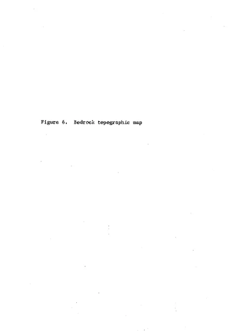
A final approximation bedrock topographic map (see Figure 6) was
prepared after problem areas on the second approximation map were field
checked. Four main bedrock channels systems were delineated on the
second approximation map. The Skunk, Squaw, and Des Moines bedrock
channels are reflected by the modern surface drainages of the Skunk
River, Squaw Creek, and Des Moines River, respectively. The fourth bed
rock channel extends southeastward from a location midway between Ames
and Boone. This has been identified by Twenter and Coble (1965) as
39
1000
900
1050
•950
'850
1 )ROCK TOPOGRAPHIC MAP
I
SCALE
S SMILES OONTOUR INTERVAL - SO FEET
40
The Squaw bedrock channel and its tributaries are the largest of
the channel systems in the Upper Skunk River Basin. It extends in a
northwest-southeast direction with major channels branching to the
north and the south in an area northwest of Gilbert in T85N, R25W.
One branch joins the Jordan channel to the south. The northern branch
extends through the central portion of the modern Upper Skunk River
Basin near Jewell and on north toward Blairsburg. The Skunk bedrock
channel is shorter, extending to the northeast from Ames to the
vicinity of Story City. The Squaw and Skunk bedrock channels are
separated by a local bedrock high at Ames and meet at the southern
end of the city where the modern streams join. The Skunk-Squaw bedrock
channel appears to join the Jordan channel south of Ames. The Des
Moines River bedrock channel lies outside the Skunk River Basin and
follows the Des Moines River northward. A branch from the Des Moines
channel extends to the northeast following the Boone River to Webster
City. The Des Moines bedrock channel appears to join the Squaw channel
northwest of Stratford. In general, the upland bedrock surface begins
at the 950-foot mean sea level contour elevation. This upland surface
is located in the northeastern sector and southwestern edge of the
study area. Thus,a northwest-southeast trending lowland exists and is dis
sected by deeper bedrock channels trending southeast-northwest and north
west-southeast. Twenter and Coble (1965) presented a regional bedrock
topographic map of central Iowa in which the northwest-southeast trend
ing lowland extended beyond the Study Area (see Figure 7). The
northeast-southwest and southeast-northwestern trending bedrock channels resemble
Figure 7. Regional bedrock topography
R s o w m % $ * R z e # R z r w
W R.I9W.
eiUnei connKtIng point»
" of «quoi oltitud* on th# bodrock turfoai; contour intervol 50 fW
STUDY AREA
R%** R25W R 24« R2)W 2«t R 'W R 20W R I9W R 18* RiT« RIS
R !6W R I9W
• S0« R2##
Jordan ehannd »
Btover
channtt Powtthiok
chonrMi
9 29W
4>-to
43
channels in this region was controlled structurally by joint systems.
Structural highs and possible fractures noted by McGee (1891), Beyer
(1898), Zimmerman (1952), Huedepohl (1956), Staub (1969), and Sendlein
and Dougal (1968) substantiate this observation.
2. Groundwater quality
Development of the final approximation water quality
maps (Figures 8, 9, 10) involved the elimination of data representing
wells penetrating deeper than the Hampton formation. This had pre
viously been done for the piezometric map. Several of the plotted
Stiff diagrams were transferred onto large-scale maps of the Squaw
Creek area because of the great number of data points. Representative
Stiff diagrams were chosen from the larger-scale maps and in turn
transferred to smaller-scale maps representing the entire basin. The
diagrams were subsequently inked and darkened in order to facilitate
interpretation. A typical Stiff diagram is shown in Figure 2-B.
The three maps, representing the bedrock (Upper Mississippian)
channel sands, and shallow sands (less than forty feet in depth), were
compared by being superimposed on each other. A general coincidence
of pattern shapes was noted between the three maps. Lateral variation
was also noted. This resulted in defining several regions where
distinguishable patterns were characteristic. Vertical coincidence be
tween the three maps was still observed within each region. Table 2
describes each region. The regions were separated on the basis of rela
tive amounts of sulfate, nitrate and chloride. Portions of the Stiff
diagrams, representing ions other than those used for regional sub
IBI
I-Cta
XL - A(3)
n - B(i)
I-A(3)
%- Diai
J
KEY .WILL LOCATION •
GROUND WATER QUALITY
BEDROCK
T
H- 8(2)
27
UNO WATER QUALITY MAP BEDROCK
SCALE
3 SMILM
KEY
UPPER S T I F F OIAQRAM
Na-K-' ® 'EPM ' ' '
4—•—Si ' ' so°^
LOWER STIFF OIAORAM
GROUND WATER QUj
H- 8(2) I- A(i»
TtCii»
H
I- A(g)GROUND WATER QUALITY MAP DEEP SAND
SCALE
I MILES
KEY
UPPER STIFF DIA8RAM
N c K , , , S i
EPM
LOWER STIFF DIAGRAM
C I P04
-t- F
T
GROUND WATER QUAI SHALLOW SA I K»r
n - 8(2) I ^ A(I) ?
I-Cd) f
CP
WATER QUALITY MAP SHALLOW SAND
SOALI
a SMILM
N
KEY
UPPER «TIFF OIAORAM
S g I i L i ^
EPM LOWER STIFF DIASRAM
CL %
-1-4—F
'' 3 i I I e s
50 a
Cable 2. Water quality regions and their characteristics
I A Moderate Sulfate, Low Nitrate
and Chloride
I B High Sulfate, Low Nitrate and
Chloride
I C High Sulfate, Moderate Nitrate
and Chloride
I D High Sulfate, Low Nitrate and
High Chloride
I E High Sulfate, High Nitrate and
Chloride
IIA Low Sulfate, Moderate-high
Nitrate or Chloride
I IB Low Sulfate, Low Nitrate and
Chloride
IXC Low Sulfate, Low Nitrate and
High Chloride
nature on the three maps. The similarity between zones indicated that
perhaps the three aquifers are hydraulically connected and a transfer
of ions has occurred between horizons. Numerical data were used to
verify this hypothesis and are shown in Tables 3 and 4. The abbrevia
tions, BR, S, and Sh are used to indicate the bedrock, chapjiel sands
and shallow sands, respectively, from which the groundwater samples
were derived. Separate regions, which represent the same chemical
characteristics (e.g., and A^) were also grouped together and
50 b
The number of sample locations which were used for determining an
average ion concentration for each region is indicated by the number
appearing in parentheses on Tables 3 and 4.
Due to the lateral variation in the area, numerical averages re