Ahi kā roa : identifying the resilience of iwi to natural hazards : a thesis presented in partial fulfillment of the requirements for the degree of Masters of Science in Earth Science at Massey University, Manawatū campus, New Zealand
177
0
0
Full text
(2) AHI-KĀ-ROA IDENTIFYING THE RESILIENCE OF IWI TO NATURAL HAZARDS. A thesis presented in partial fulfillment of the requirements for the degree of. Masters of Science In Earth Science. At Massey University, Manawatū Campus, New Zealand.. Hollei Whiungarangi Gabrielsen 2015.
(3) ABSTRACT. Māori indicators of resilience derive from strong cultural foundations based on key Māori concepts. The resilience of Ngāti Rangi, a central North Island iwi, originates from their continued residence under the shelter of their volcanic ancestor, Mt. . Ruapehu, for over 1,000 years; ahi-kā-roa. The research considered the relationship between marae placement and volcanic processes, particularly volcanic flows, and prioritised Ngāti Rangi marae for civil defence use during an emergency. Several discussions were held with members of Ngāti Rangi to understand what key cultural factors make up their resilience. Emerging findings were that (1) a correlation exists between key Māori concepts and the resilience of Ngāti Rangi which strongly formed their baseline indicators; (2) ahi-kā-roa, physically supported by population and active marae, is a measurable construct for resilience. The findings also blended together mātauranga Māori and natural hazards research, which is lacking in current emergency management approaches.. i.
(4) ACKNOWLEDGEMENTS. Ko Te Arawa te waka Ko Tongariro te maunga Ko Taupō-nui-ā-tia te moana Ko Tapeka te marae Ko Ngāti Tūwharetoa te iwi Ko Ngāti Turumakina te hapū Ko Hollei Whiungarangi Gabrielsen ahau. Tēnei te mihi mahana ki ngā pāhake me ngā kaumātua ō Ngāti Rangi, arā ko Keith Wood koutou ko Deb Te Riaki, ko Goldie Akapita, Ko Nana Biddy (Raana Mareikura), ko Korty Wilson. Kāhore anō ahau kia whai wāhi atu i tēnei kaupapa. Ki te kore koutou e whai wāhi ki tōku nei kaupapa, kua kore rawa he kiko, kua kore rawa he hua tō te mahi. Tae noa ki ngā kaimahi ō Ngāti Rangi Trust ko Hannah Rainforth, koutou ko Che Wilson, Ko Dave Milner, ko Chaana Morgan mō ō koutou taukoto mai, āwhina mai hoki, me ēra atu kōrerorero e pā ana ki ōu koutou marae, tikanga me ōu koutou whakaaro. Kei runga noa atu koutou! My polar opposite supervisors Drs Jon Procter and April Bennett for all the really awesome stuff that supervisors do but most importantly, for understanding. And for coffee. Ngā mihi nui ki a kōrua! Thanks also to Jon, Kate and Volcanic Risk Solutions for the great exposure and opportunities the world of science and GIS has to offer (and not letting my Student Loan get any bigger than it is) I am most grateful. Big mihi especially to my Matipo Street whānau for unwavering and continued support in the absence of Paka with the simple things like conversations, child minding, study dates, a bit of booze and sincere compassion. A never ending ‘thank you’ can really cover the depth of my gratitude to you both. The awesome tautoko and encouragement from all my hoa pumau Sarika, Renee, Hera, Ngahina, but also to my whānau - Ma & Pa, my beautiful sister Chloe for the small but. ii.
(5) important things. And not to forget my Uncle Hauiti for your free flowing conversation, guidance, contributions and interest in my education. Rangiaho, Kilai and Paka – my beautiful whānau who have made the most sacrifices throughout this journey. You all have been my constant. Paka, my gratitude for your steadfast support for all of my endevours goes beyond words. You are beyond amazing and you continue to teach me everyday, and for that, you humble me. We love you.. iii.
(6) Table of Contents. ABSTRACT ................................................................................................................. I ACKNOWLEDGEMENTS............................................................................................. II LIST OF FIGURES ......................................................................................................VI LIST OF TABLES .......................................................................................................VII CHAPTER 1: INTRODUCTION ..................................................................................... 1 1.1 GENERAL INTRODUCTION ...................................................................................... 1 1.2 RESEARCH OBJECTIVES AND AIM ............................................................................. 1 1.3 THESIS OUTLINE .................................................................................................. 2 1.4 STUDY AREA ....................................................................................................... 4 1.4.1 TAUPŌ VOLCANIC ZONE - RUAPEHU ............................................................................. 5 1.4.2 HAZARDS OF THE REGION – TONGARIRO VOLCANIC CENTRE ............................................. 6 1.4.3 CENTRAL PLATEAU VOLCANIC ADVISORY GROUP ............................................................ 8 1.4.4 HORIZONS REGIONAL COUNCIL APPROACH .................................................................... 9 1.4.5 NEW ZEALAND VOLCANIC WARNING SYSTEMS ............................................................. 10 1.4.6 TONGARIRO NATIONAL PARK .................................................................................... 12 1.4.7 CASE STUDY: NGĀTI RANGI ....................................................................................... 13 CHAPTER 2: LITERATURE REVIEW ............................................................................ 15 2.1 INTRODUCTION ................................................................................................. 15 2.1.1 RESILIENCE ............................................................................................................ 15 2.1.2 THE IMPORTANCE OF RESILIENCE WITHIN NATURAL HAZARDS RESEARCH ......................... 18 2.1.3 RESILIENCE AND INDIGENOUS COMMUNITIES ............................................................... 19 2.1.4 TRADITIONAL KNOWLEDGE AND RESILIENCE ................................................................. 23 2.1.5 INHERENT RESILIENCE AND ADAPTIVE CAPACITY ........................................................... 26 2.2 LIVING WITH VOLCANIC ACTIVITY ........................................................................... 27 2.2.1 MEASURING RESILIENCE ........................................................................................... 31 2.2.2 MODELS ................................................................................................................ 33 2.3 MĀORI AND HAZARDS ........................................................................................ 38 2.4 NEW ZEALAND CIVIL DEFENCE EMERGENCY MANAGEMENT ......................................... 40 2.4.1 THE 4RS ................................................................................................................ 42 2.4.2 NATIONAL CIVIL DEFENCE EMERGENCY MANAGEMENT STRATEGY ................................... 42 2.5 SUMMARY ....................................................................................................... 43 CHAPTER 3: KO NGĀTI RANGI TE IWI....................................................................... 44 3.1 INTRODUCTION ................................................................................................. 44 3.2 MĀORI CONCEPTS ............................................................................................. 44 3.2.1 TE KORE. TE PO. TE AO MARAMA ............................................................................. 44 iv.
(7) 3.2.2 WHAKAPAPA .......................................................................................................... 45 3.2.3 MAURI .................................................................................................................. 47 3.2.4 PĒPEHA.................................................................................................................. 47 3.2.5 AHI-KĀ-ROA AND MANA........................................................................................... 48 3.2.6 MAUNGA ............................................................................................................... 49 3.2.7 MARAE .................................................................................................................. 53 3.2.8 MĀTAURANGA MĀORI ............................................................................................. 56 3.2.9 MĀORI CONCEPTS IN PARLIAMENTARY ACTS ................................................................ 56 3.3 CASE STUDY - NGĀTI RANGI ................................................................................. 58 3.4 NGĀTI RANGI AND THEIR COMMUNICATION OF ‘HAZARDS’ .......................................... 62 3.4.1 1945 ERUPTION ..................................................................................................... 66 3.4.2 1953 TANGIWAI DISASTER ....................................................................................... 67 3.4.3 1995/1996 ERUPTION EPISODE ............................................................................... 67 3.4.4 CONSULTATION AND INVOLVEMENT PRE: 2007 LAHAR .................................................. 68 3.4.5 CURRENT COMMUNICATION. .................................................................................... 70 3.5 SUMMARY ....................................................................................................... 70 CHAPTER 4: KO RUAPEHU TE MAUNGA................................................................... 72 4.1 INTRODUCTION ................................................................................................. 72 4.2 VOLCANIC HAZARDS AND ERUPTION STYLES OF MT RUAPEHU ...................................... 72 4.2.1 LAHAR ................................................................................................................... 72 4.2.2 LAVA DOMES AND LAVA FLOWS................................................................................. 75 4.2.3 PYROCLASTIC FLOWS................................................................................................ 75 4.2.4 VOLCANIC DEBRIS AVALANCHE .................................................................................. 76 4.2.5 ASH FALL/TEPHRA ................................................................................................... 76 4.2.6 VOLCANIC GASES AND ACID RAIN .............................................................................. 78 4.3 NEW ZEALAND CIVIL DEFENCE AND EMERGENCY MANAGEMENT ................................... 78 4.3.1 MITIGATION MEASURES ........................................................................................... 80 4.3.2 ECONOMY .............................................................................................................. 80 4.3.3 ECONOMIC IMPACTS FROM VOLCANIC ACTIVITY ........................................................... 81 4.4 SUMMARY ....................................................................................................... 83 CHAPTER 5: METHODOLOGY .................................................................................. 84 5.1 INTRODUCITON ................................................................................................. 84 5.1.1 RESEARCH CONSTRAINTS .......................................................................................... 84 5.1.2 OBSERVATION ........................................................................................................ 85 5.1.3 ETHICS APPROVAL ................................................................................................... 85 5.2 APPROACH ....................................................................................................... 85 5.2.1 QUANTITATIVE AND QUALITATIVE RESEARCH APPROACHES ............................................ 85 5.2.2 KAUPAPA MĀORI RESEARCH APPROACH ..................................................................... 86 5.3 DATA COLLECTION ............................................................................................. 90 5.3.1 MARAE SURVEYS ..................................................................................................... 90 5.3.2 DISCUSSIONS WITH IWI............................................................................................. 92 5.4 ANALYSIS ......................................................................................................... 93 5.4.1 GEOGRAPHICAL INFORMATION SYSTEMS (GIS) ............................................................. 93 v.
(8) 5.4.2 RESILIENCE FRAMEWORK .......................................................................................... 94 5.5 SUMMARY ....................................................................................................... 94 CHAPTER 6: RESULTS .............................................................................................. 95 6.1 INTRODUCTION ................................................................................................. 95 6.2 RESULTS OF IWI DISCUSSIONS ............................................................................... 95 6.2.1 MARAE ................................................................................................................. 96 6.2.2 EMERGENCY MANAGEMENT – CONSULTATION AND INVOLVEMENT.................................. 97 6.2.3 INTERGENERATIONAL LEARNING AND KNOWLEDGE SHARING ......................................... 100 6.2.4 RESILIENCE/AHI-KĀ-ROA......................................................................................... 102 6.3 MARAE AUDIT ................................................................................................ 105 6.4 SUMMARY ..................................................................................................... 119 CHAPTER 7: DISCUSSION ...................................................................................... 120 7.1 INTRODUCTION ............................................................................................... 120 7.2 MARAE ......................................................................................................... 120 7.3 AHI-KĀ-ROA – IN ESSENCE, RESILIENCE .................................................................. 124 7.4 NGĀTI RANGI AND THEIR AHI-KĀ-ROA .................................................................. 126 7.4.1 MARAE: THE STRONGHOLD FOR IWI. THE FOUNDATION FOR RESILIENCE ......................... 128 7.4.2 RESILIENCE EQUATION............................................................................................ 130 7.4.3 MEASURING NGĀTI RANGI RESILIENCE – GUIDING FRAMEWORK .................................... 130 7.4.4 LOCAL PEOPLE – LOCAL VOLCANIC CLIMATE............................................................... 131 7.4.5 VULNERABILITY ANALYSIS ........................................................................................ 132 7.4.6 IDENTIFYING INDICATORS ........................................................................................ 132 7.4.7 MITIGATION AND PREPARATORY MEASURES .............................................................. 135 7.4.8 FIELD TESTING ....................................................................................................... 135 CHAPTER 8: CONCLUSION ..................................................................................... 136 9.. REFERENCES ................................................................................................. 138. APPENDICES......................................................................................................... 162 APPENDIX 1. INFORMATION SHEET FOR MARAE CLUSTER GROUPS 2014 ........................... 162 APPENDIX 2: MARAE VISIT LETTER ........................................................................... 164 APPENDIX 3: DISCUSSION GUIDE WITH K. WOOD. ........................................................ 165 APPENDIX 4: DISCUSSION GUIDE WITH WHANGAEHU PAEPAE. ........................................ 166 APPENDIX 5: NGĀTI RANGI MARAE CLASSIFICATION TABLE ............................................ 167. List of Figures FIGURE 1. NGĀTI RANGI ROHE: CENTRAL NORTH ISLAND, NEW ZEALAND....................................................... 4 FIGURE 2. TAUPŌ VOLCANIC ZONE (TVZ): MT. RUAPEHU LOCATED AT THE SOUTHERN END OF THE TVZ. ............. 5. vi.
(9) FIGURE 3. NEW ZEALAND VOLCANIC ALERT LEVEL SYSTEM APPLICABLE TO ALL NEW ZEALAND VOLCANOES AND SEPARATING VOLCANIC UNREST (VAL 0-2) AND ERUPTION (VAL 3-5). ................................................ 10 FIGURE 4. BIRDS EYE VIEW OF MT. RUAPEHU CENTRAL NORTH ISLAND, NEW ZEALAND: THIS FIGURE OUTLINES THE VOLCANIC RING PLAIN THAT EXTENDS OUTWARDS FROM THE MAIN CONE. THE BUND BUILT PRIOR TO THE 2007 WAS AIMED AT REDUCING THE LIKELIHOOD OF A LAHAR FLOW INTO LAKE TAUPŌ. TE WAI-Ā-MOE – THE CRATER LAKE. ........................................................................................................................... 11 FIGURE 5. THE BUND: A WALL CONSISTING OF ROCKS, SOIL AND RUBBLE BUILT UP ABOVE A SECTION OF THE WHANGAEHU RIVER TO RESTRICT LAHAR FLOW INTO THE TONGARIRO CATCHMENT. ............................... 30 FIGURE 6. MAYUNGA'S CAPITAL-BASED APPROACH: DISASTER RESILIENCE INDICATORS .................................. 35 FIGURE 7. MODEL TO MEASURE RESILIENCE TO HAZARD EFFECTS FOCUSING ON THE PERCEPTION OF COMMUNITIES TO HAZARDS. ............................................................................................................................ 36 FIGURE 8. DISASTER RESILIENCE OF PLACE (DROP) MODEL FLOWCHART OUTLINING AN OVERAL PROCESS THROUGH THE ENTIRETY OF AN EVENT.......................................................................................................... 37 FIGURE 9. VISUAL REPRESENTATION OF THE RELATIONSHIP THAT EXISTS BETWEEN WHAREPUNI AND ATUA. .......... 55 FIGURE 10. TE WAI-Ā-MOE, MT. RUAPEHU: TAKEN DURING A RECENT VISIT TO THE CRATER LAKE, JANURARY 2015. ..................................................................................................................................... 61 FIGURE 11. TE ONE TAPU: FROM THE EASTERN SIDE OF RUAPEHU FLOWS THE WHANGAEHU RIVER, A TUPUNA AWA OF NGĀTI RANGI. LOCATED ON THE TOP LEFT IS EVIDENCE OF THE BUND BUILT UP PRIOR TO THE 2007 LAHAR. .............................................................................................................................................. 69 FIGURE 12. NGĀTI RANGI ROHE MAP: NGĀTI RANGI MARAE PLACEMENT IN RELATION TO MAPPED LAHAR RISK ZONES (DISPLAYED IN COLOUR BASED ON RETURNED PERIODS). ........................................................... 74 FIGURE 13. ATIHAU WHANGANUI INCORPORATION LAND-USE WITHIN THE RUAPEHU AND WHANGANUI REGIONS, NEW ZEALAND. ......................................................................................................................... 83 FIGURE 14. TE KĀHUI O PAERANGI IS THE NGĀTI RANGI RŪNANGA. ITS STRUCTURE IS BASED ON MARAE REPRESENTATION AND IS CATCHMENT BASED................................................................................. 106 FIGURE 15. MAP OF RAKETAPAUMA MARAE IN RELATION TO VOLCANIC FLOWS ........................................... 109 FIGURE 16. MAP OF KURATAHI MARAE IN RELATION TO VOLCANIC FLOWS. ................................................. 110 FIGURE 17. MAP OF TIRORANGI MARAE IN RELATION TO VOLCANIC FLOWS. ................................................ 111 FIGURE 18. MAP OF NGĀ MŌKAI MARAE IN RELATION TO VOLCANIC FLOWS. .............................................. 112 FIGURE 19. MAP OF MAUNGĀRONGO MARAE IN RELATION TO VOLCANIC FLOWS......................................... 113 FIGURE 20. MANGAMINGI MARAE IN RELATION TO VOLCANIC FLOWS. ....................................................... 114 FIGURE 21. RAETIHI PĀ IN RELATION TO VOLCANIC FLOWS. ...................................................................... 115 FIGURE 22. MOTE KATOA MARAE IN RELATION TO VOLCANIC FLOWS. ........................................................ 116 FIGURE 23. TUHI ARIKI MARAE IN RELATION TO VOLCANIC FLOWS. ............................................................ 117 FIGURE 24. MEASURING IWI RESILIENCE TO NATURAL HAZARDS: A FRAMEWORK. ....................................... 131 FIGURE 25. DROPO MODEL FLOWCHART: CULTURAL ADAPTATION.......................................................... 134. List of Tables TABLE 1. MT. RUAPEHU ERUPTION SCENARIOS INDICATING SMALL THROUGH TO LARGE ACTIVE SCENARIOS. .......... 9 TABLE 2. VOLCANIC EXPLOSIVITY INDEX: INDICATING THE SIZE, HEIGHT AND VOLUME OF EJECTED MATERIAL FROM A VOLCANO DURING A VOLCANIC ERUPTION. ...................................................................................... 12 TABLE 3. DISCUSSIONS ON RESILIENCE: WHAT HAS BEEN DESCRIBED ALREADY................................................ 19 TABLE 4. DESCRIBING THE DIFFERENCE BETWEEN A COMMUNITY BEING PREPARED FOR AND RESPONDING TO INDIVIDUAL EVENTS VS. A RESILENT COMMUNITY WITH LONG TERM VISION AND GOALS DRIVEN BY LOCAL COMMUNITIES AS OPPOSED TO GOVERNMENT LED INITATIVES............................................................. 21 TABLE 5. COMMUNITY BASED OPTIONS FOR DEALING WITH ENVIRONMENTAL HAZARDS. ................................ 28. vii.
(10) TABLE 6. RECENT AND HISTORICAL ERUPTIONS RESULTING IN FATAL CONSEQUENCES ON LOCAL AND DISTAL POPULATIONS. .......................................................................................................................... 29 TABLE 7. THEORETICAL MODELS AIMED AT MEASURING RESILIENCE .............................................................. 32 TABLE 8. VOLCANIC HAZARDS TYPES PRE-HISTORIC MĀORI WITHIN NEW ZEALND POTENTIALLY EXPERIENCED. ...... 39 TABLE 9. RESPONSIBILITIES AND INTERESTES OF NEW ZEALAND STAKEHOLDERS WITHIN THE CIVIL DEFENCE AND EMERGENCY MANAGEMENT PLANNING. ......................................................................................... 41 TABLE 10. FEW OF THE FIRST MĀORI VALUES AND TERMS THAT WERE INCLUDED IN STATUTORY ACTS. ................ 57 TABLE 11. THE NGĀTI RANGI NAMES FOR RUAPEHU ................................................................................. 60 TABLE 12. PHYSICAL IMPACTS RESULTING FROM ASH FALL DURING THE 1995/96 RUAPEHU ERUPTION EPISODE. .. 82 TABLE 13. KEY PRINCIPLES THAT ARE CENTRAL TO UNDERTAKING KAUPAPA MĀORI RESEARCH .......................... 88 TABLE 14. DESCRIPTION THE FACILITIES PRESENT AT EACH NGĀTI RANGI MARAE .......................................... 107 TABLE 15. PRIORITISATION OF NGĀTI RANGI MARAE .............................................................................. 121 TABLE 16. NGĀTI RANGI LAYERS OF RESILIENCE ..................................................................................... 128 TABLE 17. POTENTIAL INDICATORS FOR QUANTIFYING NGĀTI RANGI RESILIENCE .......................................... 133. viii.
(11) Chapter 1: INTRODUCTION. 1.1 General introduction The incorporation of the human facet of emergency management, more specifically with volcanic hazard management, within New Zealand is becoming increasingly recognised. The rise of resilience-based research in conjunction with natural hazard research can provide a bridge to the human facet of this discipline. The exploration of resilience specific to Māori and particularly iwi (tribes) is slowly gaining traction, but the research has yet to define the factors that contribute to resilience of Māori. Mātauranga Māori, traditional knowledge held by iwi Māori, can present a set of experiences through generations of interactions and exposure to volcanic activity that can contribute positively to current emergency management strategies. This research examines and identifies indicators that contribute to the resilience to volcanic events for one iwi, Ngāti Rangi. Ngāti Rangi reside on the southern reaches of Mt. Ruapehu and hold ahi-kā-roa (long-term occupation) in the Central Volcanic Plateau of the North Island, New Zealand. They also have an ancestral connection to the maunga (mountains) of that area, specifically Mt. Ruapehu. Their indicators provide an initial framework or baseline for measuring iwi resilience to natural hazards broadly, and volcanic hazards specifically.. 1.2 Research Objectives and Aim The focus of this research is based on identifying the resilience of iwi to natural hazards. The main objective was to identify the cultural attributes that contribute to the resilience of Ngāti Rangi, an iwi that resides on the southern side of Mt. Ruapehu. The main research objective is to provide a framework to. 1.
(12) adequately measure the resilience of Ngāti Rangi to volcanic hazards. This framework may also be useful to other iwi who are exposed to such hazards.. The specific objectives of this research were to: Objective 1:. Provide an understanding of resilience and its weighting within. emergency management and unravel what resilience means to Māori and more specifically Ngāti Rangi. Identify key indicators that represent Ngāti Rangi and their resilience to volcanic processes based on their mātauranga Māori and collection of experiences derived from their residence at the foot of Mt. Ruapehu. Objective 2:. Examine the volcanic climate of the Central North Island and its. resulting impacts on the local communities that reside in the area whilst gaining perspective on the Ngāti Rangi relationship and perspective of Ruapehu and his volcanic activity. Objective 3:. Define the risks posed to Ngāti Rangi marae1 from natural. hazards within the area to further articulate which marae are suited as Civil Defence Shelters. Objective 4:. Examine key models that measure resilience and develop a. framework to assess iwi resilience to natural hazards.. 1.3 Thesis Outline This thesis is outlined as follows: Chapter One: This Chapter is fundamentally introductory. It seeks to provide descriptions on the location of this research, focusing largely on the geomorphological formation of the Central Plateau, in particular Mt. Ruapehu. 1. In this thesis, the term ‘marae’ is used to denote not only the ‘marae ātea’ or the courtyard in front of the ‘wharenui’ or meeting house, but the whole complex of buildings that exist within the grounds.. 2.
(13) Subsequently it denotes the generic hazards presented and experienced by the region and how local authorities and advisory groups approach hazard management. Chapter Two: This Chapter is dedicated to a literature review, which focuses heavily on content connected to resilience-based research; its development and evolution. It touches briefly on models that aim to measure resilience and then strives to introduce indigenous communities that co-exist with natural hazards. The Chapter finishes with a New Zealand focus, firstly describing the historical interaction between Māori and natural hazards and finally the guiding emergency management legislation. Chapter Three: This section predominantly seeks to understand Ngāti Rangi, their relationship to Mt. Ruapehu and the founding perspectives that drive their interaction with volcanic processes. Key generic Māori concepts that underpin the approach of Māori to natural hazard management have been explored. These concepts substantiate the importance of incorporating local and historically derived iwi knowledge into natural hazard management. Chapter Four: ‘Ko Ruapehu te Maunga’ comprises the volcanic specific data eminating from Ruapehu. Its focus is on the primary volcanic processes that have the potential to impact on the local and national communities. It aims to articulate the likelihood of these separate volcanic events with historical insights into frequency and impacts. Chapter Five: Chapter Five contains the methodology used to obtain the data for this study. Chapter Six: The results Chapter focuses on two main elements: perspectives, history and experiences of key Ngāti Rangi participants as a result of discussions and interviews, and a risk analysis of individual Ngāti Rangi marae. Chapter Seven: The seventh Chapter of this thesis contains a discussion. Its key focus is the resilience of iwi and its links to the key Māori concepts described in Chapter 2, while seeking to prioritise individual marae based on the risk analysis. 3.
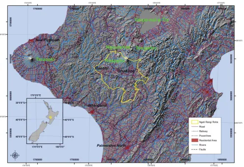
(14) results. This Chapter also discusses and outlines a proposed framework that seeks to guide other users in measuring the resilience of iwi to natural hazards. Chapter Eight: The final Chapter provides a conclusion to this research.. 1.4 Study Area The study area for this research encompasses the Ngāti Rangi tribal lands predominantly focusing on marae and volcanic flows, or more explicitly lahars originating from Mt. Ruapehu in the Cental North Island of New Zealand. This land area equates to 2,498 km2 and has a total population of 4,911 with 1,917 of this total identifying as Māori (Statistics New Zealand, 2013). In this area, the research has concentrated on historic and current lahar flow paths, which are confined to major catchments on the southern side of Mt. Ruapehu.. Figure 1. Ngāti Rangi Rohe: Central North Island, New Zealand. 4.
(15) 1.4.1 Taupō Volcanic Zone - Ruapehu The converging of the Australian and Pacific tectonic plates provides the driver of volcanism within New Zealand. As a product of this convergence the Taupō Volcanic Zone is a back arc rift (Acocella et al., 2003). Central to this study is Ruapehu, situated at the southern end of the Taupō Volcanic Zone (TVZ). Ruapehu is the largest and most active volcano in the North Island standing at 2797 m high (Neall et al., 2010). The TVZ displays major geomorphological features, which provide an illustration of the formation of the landscape through historical eruptions.. Figure 2. Taupō Volcanic Zone (TVZ): Mt. Ruapehu located at the southern end of the TVZ. (Science Learning, 2010).. Ruapehu, along with Tongariro and Ngauruhoe, is located within the Tongariro National Park, one of New Zealand’s United Nations Educational, Scientific and Cultural Organization (UNESCO) World Heritage sites2. The Tongariro National. 2 Other New Zealand UNESCO sites are the New Zealand Sub-Antarctic Islands which consist of. five island groups (The Snares, Bounty Islands, Antipodes Islands, Auckland and Campbell Island) and Te Wahipounamu – South West New Zealand (UNESCO, 2014b).. 5.
(16) Park is recognised not only for the natural values the landscape delivers, but also for the cultural values associated with these maunga (UNESCO, 2014a). This recognition indicates the cultural importance placed on this area by local iwi and by UNESCO who govern the World Heritage List and locations worldwide and awarded this dual status in 1993 (recognition of cultural and environmental values) (Keys & Green, 2004). The Tongariro National Park is managed by the Department of Conservation, a Crown entity (Department of Conservation, 2006b). Despite the recognition of the cultural significance of the Tongariro to local iwi and hapū (sub tribes), they have little involvement in its management.. 1.4.2 Hazards of the Region – Tongariro Volcanic Centre Mt. Ruapehu is a composite andesitic stratovolcano built up over a series of smaller cones throughout a sequence of eruptions, with the oldest dated rocks listed as 230,000 years old (Houghton et al., 1996). There is evidence of a historic lava flow present in preserved andesite pebbles in the Whanganui District that are at least 300,000 years old (Neall et al., 1999). Stratovolcanoes are susceptible to collapse, thus creating debris avalanches and lahars that inundate the surrounding ring plain and outer reaches (Houghton et al., 1996).. The ring plain surrounding Ruapehu is formed principally from deposits of tephra, debris flow and hyperconcentrated flood flows (Donoghue, 1991). Glaciers have contributed to erosion of Mt. Ruapehu during the Last (Otira) Glaciation, where they were largely more extensive (Hackett, 1985) in comparison with the glaciers today.. The point of difference that makes Ruapehu unique from other volcanoes worldwide is the presence of the Crater Lake (referred to as Te Wai-ā-moe by Ngāti Rangi), which exists over the active vent. The presence of the Crater Lake during activity allows for phreatomagmatic eruptions dominated by magmatic and hydrovolcanic fragmentation (Chester, 1993). Ruapehu has undergone. 6.
(17) several major phreatomagmatic eruptions in the last 50 years including 1969, 1971, 1975, 1995, 1996 (Cronin et al., 1996) and 2007 (Kilgour et al., 2010).. Evidence of tephra erupted from Ruapehu is preserved on the eastern side of Ruapehu, largely deposited by westerly winds (Donoghue et al., 1997). By worldwide standards, Ruapehu erupts quite frequently in comparison to other volcanoes (Houghton et al., 1996); however, the volume of eruptive material is relatively low, being usually within the parameters of 104 – 107 m3 (Houghton et al., 1987). The volume of ejected material contained within the plume is significantly smaller in proportion to other volcanic eruptions in the past; notably in comparison to Mt. St Helens (1980), Tarawera (1886), Mt. Pinatubo (1991), Taupō (181) and Tambora (1815). Ruapehu eruptions are significantly smaller by worldwide standards (Houghton, et al., 1996).. The current risk climate for the Ngāti Rangi iwi located in the southern reaches of the Taupō Volcanic Zone varies from earthquakes to flooding, with the main focal point of this research revolving around volcanic hazards. Volcanic activity is considered fourth on the list of localised hazards within the ManawatūWhanganui region, which shares Mt. Ruapehu with the Waikato region: 1. Earthquake 2. Locally generated tsunami 3. Human pandemic 4. Volcanic activity at Mt Ruapehu 5. Sea level rise 6. Volcanic activity at Mt Taranaki 7. Beach erosion and flooding 8. Flooding 9. Agricultural drought 10. Cyclones (Horizons Regional Council, 2014).. 7.
(18) 1.4.3 Central Plateau Volcanic Advisory Group Another means to address and discuss volcanic activity was to bring together all factions of volcanic expertise, emergency managers, iwi, planners and other stakeholder representatives within the Central Plateau to create the Central Plateau Volcanic Advisory Group (CPVAG). The purpose of the CPVAG is to provide a forum for discussion, research and planning for the hazards present within the Central Plateau. It is based largely on an integrated approach to managing volcanic hazards in this area and aligns with the Civil Defence and Emergency Management 4Rs approach. The main outcome of this advisory group is to work directly with the local communities with and through members to increase community resilience to volcanic hazards within the Central Plateau (Central Plateau Volcanic Advisory Group, 2009).. The core vision of the Central Plateau Volcanic Advisory Group is: ‘Communities understanding and managing their volcanic hazards’ (Central Plateau Volcanic Advisory Group, 2009, p. 6). As a means to further understand the potential risks, likelihoods of occurrence, durations, and areas threatened from future eruptions within the Central Plateau, the group developed a scenario table based on historic activity of Ruapehu.. 8.
(19) LIKELIHOOD AREA AT RISK. MAGMA VOLUMES LAHAR VOLUMES (% of lake volumes) ASSOCIATED HAZARDS. TYPICAL DURATION. None. None. None. Increased gas at summit area. Possible felt seismicity. Small 1 per year Summit Area Whangaehu Lahars Lake edge. Moderate 1 in 10 years Summit Area Whangaehu, Whakapapa Ski field Lahars. Very Large 1 in 500 years. <0.01 km3. Large 1 in 50 years Summit Area Whakapapa, Turoa, Tukino Ski fields Lahars Ash fall beyond ring plain 0.01 – 0.1 km3. <0.001 km3 <1%. 1-10%. 10-30%. >30%. Geysering in lake, increased wave action. Ballistics to 3km Lahars in 2-3 catchments Ash fall to <10km. Ballistics, ash falls to >10km, lahars in multiple catchments. Ballistics lahars in multiple catchments, Significant ash fall. Hours to weeks. Days to weeks. Days – weeks – months. Months - years. >0.1 km3. Table 1. Mt. Ruapehu Eruption Scenarios indicating small through to large active scenarios. (Central Plateau Volcanic Advisory Group, 2012, p. 5).. Table 1 presents typical scenarios regarding different eruption sizes, vulnerable areas, and lahar volumes. These data inevitably allow some comprehension of the potential risks at a local and national level.. 1.4.4 Horizons Regional Council Approach In addition to the CPVAG, the Horizons Regional Council approach towards emergency management is by creating resilient communities. This is executed through bridging established measures, such as land use management and risk reduction (Britton & Clark, 2000). The Manawatu-Wanganui Civil Defence and Emergency Management (CDEM) focuses its risk management on four key areas, social, built, economic and natural environment (Lloyd, 2009), and they too are involved are involved with the CPVAG.. 9.
(20) 1.4.5 New Zealand Volcanic Warning Systems New Zealand has a number of warning systems in place to communicate the level of volcanic activity. The Volcanic Alert Level System is used to indicate the current level of activity with any New Zealand volcano.. Figure 3. New Zealand Volcanic Alert Level System applicable to all New Zealand volcanoes and separating volcanic unrest (VAL 0-2) and eruption (VAL 3-5). (GeoNet, 2013).. Another system currently in place specifically for Ruapehu and/or Tongariro lahar events is the Eastern Ruapehu Lahar Alarm & Warning System (ERLAWS). 10.
(21) (Becker et al., 2010; Keys & Green, 2004). This system was installed to monitor lahar activity primarily for the Crater Lake dam break of 2007, but it remains in place for future lahar events. The Whangaehu River catchment is the main channel for volcanic flows commencing at Te Wai-ā-moe (Crater Lake) and traversing through the southern reaches of the catchment and culminating at the Tasman Sea. Lahar behaviour is determined by several factors, which include the trigger mechanism, the nature of source material, event size and the hydrological conditions of the river at the time of the event (Hodgson et al., 2010).. Figure 4. Birds eye view of Mt. Ruapehu central North Island, New Zealand: This Figure outlines the volcanic ring plain that extends outwards from the main cone. The Bund built prior to the 2007 was aimed at reducing the likelihood of a lahar flow into Lake Taupō. Te Wai-ā-moe – The Crater Lake.. The Volcanic Explosivity Index in Table 2 showcases volcanic eruptions in relation to their explosiveness, volume of ejecta and the height of the ash cloud. Within recent history, Ruapehu experienced an eruption with a VEI Index of 2 based on the 1971 eruption.. 11.
(22) VEI Index. General description. Ejecta volume (m3). Plume height (km). Eruption Classification. Examples. 0 1. Non-explosive Gentle. <104 >104. <0.1 0.1-1. Kilauea Nyiragongo (2002). 2. Explosive. >106. 1-5. 3. Severe. >107. 3-15. 4. Cataclysmic. >0.1km3. 10-25. 5. Paroxysmal. >1km3. 20-35. Hawaiian Hawaiian/ Strombolian Strombolian/ Vulcanian Vulcanian/ Pelean Pelean/ Plinian Plinian. 6. Colossal. >10km3. >30. 7 8. Super-colossal Mega-colossal. >100km3 >1,000km3. >40 >50. Plinian/ Ultra-Plinian Ultra-Plinian Supervolcanic. Ruapehu (1971) Nevado del Ruiz (1985) Eyjafyallajokull (2010) Mount St. Helens (1980) Pinatubo (1991) Tambora (1815) Yellowstone (Pleistocene). Table 2. Volcanic Explosivity Index: Indicating the size, height and volume of ejected material from a volcano during a volcanic eruption. (Adapted from Pyle, 2000, p. 273; Wheeling Jesuit University, 2014).. 1.4.6 Tongariro National Park The Tongariro National Park Management Plan 2006-2016 guides the Department of Conservation management of the area (Department of Conservation, 2006b). This document outlines the roles and responsibilities of the Department and the policies that guide the use of this area. Notwithstanding this, the responsibility of managing natural hazards lies with the district and regional councils, while monitoring changes in, and conducting research on volcanic activity is undertaken in conjunction with research providers such as the Institute of Geological and Nuclear Sciences (GNS Science)3 and Massey University4. The Department of Conservation describes the risks from natural hazards as taking ‘two main forms’ (Department of 3. GNS Science are a Crown Research Institute dedicated to research in earth science, energy & resources, natural hazards and environment & materials (GNS, 2015). 4 Massey University, Palmerston North and in particular Volcanic Risk Solutions focuses on volcanic hazard and risk management research (Massey University, 2015).. 12.
(23) Conservation, 2006b, p. 93): (1) flows such as lahars, pyroclastic flows, lateral blasts, landslides/floods and lava flows, and (2) air-borne materials such as rocks, tephra and toxic gases.. Ruapehu is unique in the sense that the Crater Lake, Te Wai-a-moe, is located over the vent of the volcano. Keys and Green (2004) observe that only one other crater lake (Mt. Kelut in Java, Indonesia) similar to that of Ruapehu exists within the world, indicating the importance of Ruapehu to the scientific research community.. 1.4.7 Case Study: Ngāti Rangi The case study chosen for this research is Ngāti Rangi, a Central North Island iwi who have held ahi-kā-roa (unbroken occupation) over the area for 1000 years and are a pre-fleet iwi5. They have an intense and living relationship with their ancestral maunga (mountain), whom they refer to as Matua te Mana. As the human voice for their maunga, Ngāti Rangi know of and protect his special places and understand what it means to be living with a volcano and subsequently avoid specific areas.. Ngāti Rangi are a highly organised iwi represented by their legal entity Ngāti Rangi Trust, which is guided by their rūnanga (governing body) Te Kāhui o Paerangi. Te Kāhui o Paerangi is made up of representatives of the 15 Ngāti Rangi marae6. The marae are also grouped in ‘clusters’ or ‘paepae7’ based on their geographical location in relation to principal river catchments. These clusters or paepae are: Ngā manga o Hautapu (Hautapu Paepae), Te Wera o Whangaehu (Whangaehu Paepae), Ngā ia o Mangawhero (Mangawhero Paepae) and Te Waimarino (Makōtuku-Manganui Paepae). 5 A ‘pre-fleet iwi’ is a term used to describe iwi that arrived to Aotearoa outside of the great. waka migration through the Pacific Ocean. Figure 11 p. 106 provides a visual structure to Te Kāhui o Paerangi Rūnanga 7 Paepae is often used to describe the seating in which speakers at a powhiri (official welcome at a marae) are placed. In this term, it describes the key representatives of each cluster group. 6. 13.
(24) Ngāti Rangi Trust has a current relationship with Massey University and in particular, the Volcanic Risk Solutions unit within the Institute of Agriculture and Environment. Ngāti Rangi have been consulted on past natural hazard mitigation measures post the 1995/96 eruptions and prior to the 2007 lahar. This research project is based around identifying a means to measure how resilient iwi are to natural hazards, more importantly volcanic hazards or processes. There are many iwi around New Zealand that reside in and around active volcanoes; the Central Plateau being home to both Ruapehu and Tongariro, highly prized by their respective iwi8. A more detailed description of Ngāti Rangi is given in Chapter 3.. 8. Ngāti Tūwharetoa are the main iwi to the north of Ngāti Rangi and also share the maunga within the Tongariro National Park. Ngāti Hikairo are recognised as hapū of Ngāti Tūwharetoa and hold ahi-kā at the base of Tongariro. Ngāti Uenuku have whakapapa links to Ngāti Rangi and share many marae, whānau and hapū. They reside at the southern end of Ruapehu.. 14.
(25) Chapter 2: Literature Review. 2.1 Introduction This Chapter examines the literature on resilience and explores the complexities that are held within this discipline. It goes further to review the importance of resilience within natural hazards research and its management and look at models that measure resilience. Finally, it looks to identify whether a relationship exists between resilience research and indigenous communities worldwide, including Māori communities. The chapter ends with a brief examination of current legislation and emergency management strategies that guide civil defence within New Zealand.. 2.1.1 Resilience. ‘Waves of adversity and layers of resilience’ (Glavovic, 2005 as cited in Seville, 2009).. The evolution of the term resilience and the acknowledgement of its importance within emergency management for communities, towns and cities are paramount. The use of resilience as a term, an approach, and a framework is imperative to communities as a means of strengthening and protecting their livelihoods, assets, and ways of life. Discerning between and defining each of these individual ‘traits’ of resilience from the vast body of research is highly complicated due to the multiple definitions and applications in a range of subjects. For resilience to provide meaning and significance to communities, it is required to act as a tool for strengthening, protecting and providing communities with the means to not only survive a natural hazard event, but to ultimately recover.. 15.
(26) Glavovic (2005) describes resilience as dynamic. His analogy captured in the above quote can be used to describe how systems and threats interact, or the interaction between the resilience of communities and crises. It indicates that with enough effective layers of resilience, threats will not destroy the whole. The effectiveness of these layers of resilience will also be based on what the system has previously experienced (Seville, 2009).. Glavovic’s description of resilience is one of many definitions of resilience that exist in a wider context besides natural hazards research.. It is widely. acknowledged that Holling (1973) initiated the concept of resilience within ecology (Mayunga, 2007; Ainuddin & Routray, 2012; Norris et al., 2008; Burton, 2015). Timmerman (1981) however was potentially the first to assign the definition of resilience in relation to natural hazards. Thereafter, the definitions and understanding of resilience have increased exponentially. Zhou et al. (2010) define resilience simply as ‘the capacity to resist and recover from loss’ (p. 22), which provides a clear representation of a definition of resilience. In spite of the simplicity with which resilience might be explained, the literature on resilience and its meaning is categorised by many divergent research paths and perspectives, resulting in no generally accepted definition. The concepts and terminology inherent within natural hazards research have wide and varied definitions that are based on the theoretical perspectives and outcomes sought by this research community. As wide as these definitions and perspectives are, so too are the criticisms over the use and perceived inappropriateness of the term resilience (Bodin & Winman 2004; Carpenter et al., 2001; Cowen, 2001; Klein et al., 2003: as cited in Norris, et al., 2008).. Not only is the research on resilience highly varied in nature, the lack of clarity surrounding the countless definitions available is problematic. Some argue that the use of resilience by the general public in reference to an event and its repercussions represents a misuse and misinterpretation of the term. Cannon 16.
(27) (2008) suggests that the inappropriate use of the term resilience in the postdisaster phase can distort the significance of its meaning and importance within the natural hazards sector. Cannon is concerned that the surviving communities are described as resilient simply because they still exist; their suffering and loss are not usually taken into account.. There are also noted theoretical differences in the natural hazards research field, which generate various individual meanings of resilience. According to Zhou et al. (2010), fundamental conceptual differences exist within this research field. These conceptual differences dictate the avenue of focus for natural hazards research. Zhou et al. (2010) categorised the divergent research paths into three systems: the social system, the ecological system, or a combination of the two. In these systems, the authors identify several themes of research, such as resilience as a biophysical attribute, a social attribute, a social-ecological attribute, and a geographically centered attribute. Norris et al. (2008) explain community resilience as a metaphor, a theory, a set of capacities and as a strategy.. Frazier et al. (2013) examine aspects of resilience that are researched rather than conceptual differences, such as those outlined by Zhou et al. previously. These aspects include: (1) research on resilience as a process (Cutter et al., 2008), which is centered around a community’s continued growth towards not only becoming resilient but supporting their involvement in decision-making; (2) knowledge pursuit; and (3) constantly improving the growth of community capacity. The other aspect of research on resilience is focused on an outcome; that is, how a community can cope with and recover from a hazard event.. Resilience is also tied into the current capacity of a community, which Thouret (2010) describes as being dependent on a number of factors. These factors. 17.
(28) include the economic and cultural potential of the community and the strength of its preparedness to adequately deal with a disaster. There are a number of other inherent factors or values, which promote the resilience of a community, predominantly the cultural and spiritual connections not only with immediate family members but also a wider family grouping. Adger (2000) goes further to note that dependency on an ecosystem is indicative of inherent resilience particularly when it is unharmed by the changing economic climate.. 2.1.2. The Importance of Resilience within Natural Hazards Research. The importance of resilience within natural hazards research or emergency management is its use as an outcome of actions to lessen a community’s risk to natural hazards, whilst enabling them with the capability to recover from disaster. Resilience is coming to the forefront of disaster management due to the increasing impacts on human societies, livelihoods and property from natural disasters (Cutter et al., 2008; Orencio & Fujii, 2013; Zhou et al., 2010). The location of communities and at times, their lack of knowledge of natural hazards make resilience a priority for them.. The importance of resilience also rests with the capacity of the community response to a disaster (Cannon, 2008; Zhou et al., 2010). Through quantifying the level of resilience of a community initially, preparations for recovery and assessing potential losses can then occur (Frazier et al., 2013). This analysis can result in recognising, developing and strengthening the deficits that exist within the systems aimed at protecting assets and livelihoods (Cannon, 2008). Cutter et al. (2008) view resilience as an important and positive substitution to the use and measurement of vulnerability.. 18.
(29) DESCRIPTIONS AND DISCUSSIONS SURROUNDING RESILIENCE Resilience is dynamic and so too is its interaction with threats (Glavovic, 2005). Holling (1973) credited with the first description of resilience within ecology. Timmerman (1981) provided a description of resilience in the context of natural hazards. Cannon (2008) suggests the misuse of the term resilience leads to a distortion of the underlying meaning of resilience within the natural hazards sector. Norris et al. (2008) explain community resilience as a metaphor, a theory, a set of capabilities and a strategy. Frazier et al. (2013) focus on the process of communtiies achieving resilience; through involvement in decision making, knowledge pursuit and building capacity. Thouret (2010) focuses on understanding the current capacity of communities and its contribution to their resilience. Due to increasing impacts on people and property from natural disasters, resilience is becoming the forefront of disaster management (Zhou et al., 2010; Orencio & Fujii, 2013; Cutter et al., 2008). Zhou et al. (2010) and Cannon (2008) mention that the importance of resilience is tied to the ability of communities to respond to disaster. Cannon (2008) also views resilience as a positive substitution to the use and measurement of vulnerability.. Table 3. Discussions on Resilience: What has been described already.. 2.1.3 Resilience and Indigenous Communities Understanding the level of resilience within a community is vital for preparatory measures before an event, for the recovery phase, and to gain perspective on the potential economic losses (Frazier et al., 2013). Frazier et al. also discuss the difficulties in attempting to quantify resilience due to the ‘qualitative nature of resilience indicators’ (2013, p. 95). Paton (2000), therefore, outlines four key components of resilience below:. 1. Communities require adequate resources to deal with issues relating to their safety and core services after an event. 2. These communities must be able to effectively use these resources and deal with emerging issues and problems through adaptive capacity.. 19.
(30) 3. Planning and development that enable community resilience must take into account the availability of resources. 4. Adequate management of these resources to ensure their sustainability over time against times of quiescence and changes in goals, functions, and community needs.. In conjunction with these four components, Pomeroy (2011) depicts some characteristics that support a resilient rural/farming community, which could be applicable to Ngāti Rangi in the context of their community. Therefore, Pomeroy describes the resilience of rural communities as having:. 1. Strong economic base; 2. Stable succession structures; 3. Strong service infrastructure; 4. Integrated approach to challenges and decision making; 5. Adequate planning and preparation for hazardous events; 6. Community networks and participation; 7. Self belief; 8. Positive profiling of the community; 9. Community empowerment and institutional relationships; 10. Accessibility to relevant information; 11. Strong volunteering ethos and capacity; and 12. Effective leadership.. These resilience characteristics provide some crossover to indigenous communities that continue to be rural based. It also coincides with the ‘Resilience vs. Preparation’ perspective of what best represents resilience as a community centered, long-term view, which is outlined in Table 4.. 20.
(31) Resilience. Preparedness. Relationship-based. Plan-based. Whole community. Government agencies. Long term. Short term. Ongoing. Disaster-centred. Based on strengths. Risk focused. Broadly defined. Narrowly defined. Sustainable development. Build back the same. Table 4. Describing the difference between a community being prepared for and responding to individual events vs. a resilient community with long term vision and goals, driven by local communities as opposed to government led initatives. (RAND Corporation, 2014, p. 1).. Various aspects of resilience research and measurement of indigenous communities are littered throughout natural hazards research but are described in the following ways: disaster prevention (Alcántara-Ayala, 2002), disaster risk reduction (Mercer et al., 2010), and assessing the vulnerability of communities to natural hazards. Work with indigenous communities within the Pacific region has provided examples of capacity building and incorporating indigenous cultural knowledge into western scientific methodology to adequately prepare for and deal with natural hazards. For example, the community of Savo Island in the Solomon Islands is exposed to a high level of volcanic activity with a history of large fatalities (Petterson et al., 2003). Outside expertise and assistance was sought to initiate the development of strategies to address the risks from volcanic activity on the island (Petterson et al., 2003).. The development of these strategies to address the risks from volcanic activity on Savo encompassed in-depth work with the local community. This work included workshops and identifying and using local knowledge of hazards in conjunction with science to develop a disaster management plan. This process. 21.
(32) identified in some respects how crucial the political, economic and infrastructural climate is in supporting the resilience of these island nations; political drivers secured the expertise thus enabling the development and implementation of the disaster management plan. Despite the best intentions in aiding indigenous communities in developing strategies to deal with natural hazards, there can be a multitude of barriers to undertaking this work. One of the challenges identified in work carried out on Ambae Island, Vanuatu, was initially the lack of acceptance by the local population of scientific knowledge (Cronin et al., 2004b).. Breaking through the barrier of the dominance of western science is essential for indigenous cultures, as there are a significant number of deep-seated issues surrounding research, intellectual property and exploitation. These issues have led to indigenous communities distrusting researchers, their methods and their desired outcomes. As a means to alleviate such issues (Bird & Gísladóttir, 2012; Cronin et al., 2004a; Cronin et al., 2004b) researchers have used the principles of the Participatory Rural Appraisal to alter the attitudes and approach of the specialists and to promote community input and knowledge. These principles perhaps parallel kaupapa Māori research, which emphasises elements central to the Treaty of Waitangi such as participation, partnership, and protection (Robertson, 1999) of Māori throughout the research. In Vanuatu, Cronin et al. (2004b) observed that strong cultural customs prevented the indigenous peoples from accommodating standard scientific methods, but also that these methods were inconsistent with those customs and the knowledge and beliefs of the people. The researchers envisaged that Participatory Rural Appraisal would act as the instrument to incorporate traditional knowledge into the development of a hazard management plan without the risk of jeopardising the indigenous community local belief structures (Cronin et al., 2004b).. 22.
(33) Despite work by scientists and disaster management researchers to understand and improve the resilience of many indigenous cultures, Campbell (2009) indicates that many Pacific Island nations were once inherently resilient to natural hazards. Traditional disaster reduction measures describe the ways through which indigenous communities succeeded in living with natural hazards. Campbell (2009) categorised these traditional disaster reduction measures into three separate groupings: food security, fragmented agriculture and property security. Firstly, food security was one aspect utilised by these traditional societies where a focus on storing and preserving food was a regular occurrence and sustained these communities during disaster events. Secondly, fragmented agriculture was commonplace and provided another source of food security to local communities through crops not being located in the same place in case disaster events impacted on these areas. Lastly, property security allowed the protection of homes and property through their structure and location.. Colonisation introduced changes to these societies that removed the importance of their traditional and highly social practices and left communities unprepared and ill-equipped to deal with natural hazards (Zimmet et al., 1990). Globalisation and other external pressures may be processes that are out of these communities’ control, but still have far-reaching impacts on their internal processes and traditions (Mercer et al., 2010; Pelling and Uitto, 2001). Among these pressures, Paulinson (1993) found market forces to be at fault.. These. aspects may inhibit indigenous communities from being resilient. Despite this, the traditional disaster reduction measures promote resilience.. 2.1.4 Traditional knowledge and resilience Resilience has a specific focus on capacity building and being prepared enough to adequately respond to and recover from natural hazards. It is argued however, that for traditional communities to adequately prepare for hazards,. 23.
(34) traditional knowledge should be used to provide unique insight into information on historical events, as well as previous response methods. It has long been acknowledged that communities residing in a hazard-prone area over a number of generations understand hazard processes, and potentially some previous methods of response towards hazards (Campbell, 2009; Cashman & Cronin, 2008; Cashman & Giordano, 2008). Traditional knowledge and oral traditions, which derive from oral narratives (Cashman & Cronin, 2008), are valuable tools that represent an awareness and understanding of the locality. They provide an account of historical methods used to avoid, mitigate or reduce the impacts associated with natural hazards. In Iceland, historical accounts of ash fall indicated the level of severity and the resulting impact on visibility (Bird & Gísladóttir, 2012), therefore demonstrating for example what work needs to be undertaken prior to the lack of visibility settling in. These historical accounts can provide local communities with moral support. In the study by Bird and Gísladóttir (2012) one participant said: ‘I just thought about the past, the stories. How good it was that we had heard the stories, I knew that it had happened again, I knew that it wouldn’t last forever’ (Bird & Gísladóttir, 2012, p. 1271).. Those stories from Iceland outlined a natural hazard event, its impacts on the local communities, mitigation measures to undertake and perhaps some indication of its duration. Place names also hold some merit in providing further insight into a location and its history (King et al., 2008) and can be representative of an event that left an imprint on the landscape and the people. In contrast, there is still a lack of understanding on the nature of the hazards in volcanic zones, as well as a real understanding of all possible hazard types. On Java, Indonesia, Lavigne et al. (2008) identified that there was little to no actual understanding of volcanic processes, therefore the local population were not aware of the full range of volcanic hazard types, their associated risks and more importantly the areas on which they impacted. This study highlighted peoples’. 24.
(35) perceptions of risks and the importance of bringing into account the human dimension with regards to natural hazard management.. It has been heavily emphasised how imperative the human dimension is to natural hazard management (Bird et al., 2009). Understanding the interaction and relationship local communities have with the land may describe the continued existence of people in the vicinity of volcanoes. Lavigne et al. (2008) support this view by noting the rise in research relating to the human dimension of natural hazard management and, more specifically, the behaviour of people in the face of natural hazards. They outlined three significant areas to further understanding of the human dimension of hazards and the reactions to natural hazard events: (1) the perception of risk, (2) cultural beliefs and (3) socioeconomic constraints.. Individual and community perceptions of risk are based on a number of differing factors such as the nature of the hazard, its frequency, duration, past experiences and exposure to the hazard. Despite these factors contributing to risk perception, the lack of understanding of volcanic processes, the low frequency and duration combined with limited or no exposure to past events although living in an active volcanic zone, all contribute to lower perception of risk regarding volcanic hazards. Hazard knowledge and risk perception of Katla9 by locals in Iceland demonstrated the results of hazard knowledge inherited from their ancestors (Bird et al., 2009). This study indicated that exposure to and experience of volcanic hazards were discussed and recognised by the younger generation and contributed to their level of risk perception. Gregg et al. (2004) note that, in some cases, hazard awareness is not an indication of hazard knowledge and does not carry over to individual preparedness or responsiveness. 9. Katla volcano is one of the most active volcanic systems in Iceland (Larsen, 2000).. 25.
(36) 2.1.5 Inherent Resilience and Adaptive Capacity One key strength and weakness of traditional and indigenous societies in the face of natural hazards is the reliance on their local environment. Gaillard (2007) goes further to mention that due to this reliance, many traditional societies are unable to adequately recover from disasters that directly impact their lands and thus their subsistent lifestyles. Adger (2000) argues that there is a connection between ecosystem and social resilience, since communities dependent on local resources have a reliance on the entire ecosystem, as is the case with fishing communities in Asia (Bayley & Pomeroy, 1996 as cited in Adger, 2000). It is perceived that the total dependence of these societies on their local environment and its resources is a factor inhibiting their capacity for resilience. Resource depletion and the decimation of traditional and current land-use areas are situations that force evacuation and thus relocation of these societies. In these instances, the resilience of a traditional society is determined by the level at which the people resist change or welcome it, relocate or choose to remain in their traditional area, and the level of cultural adaptations that take place their society and culture to survive (Gaillard, 2007; 2006).. Inherent resilience and adaptive capacity is often associated with community resilience. Pacific Island nations, as outlined earlier, were described as being inherently resilient due to traditional practices and cultural traits that have adapted to the local environment and its associated hazards. Iwi also can stake claim to this. Traditional practices and cultural traits have allowed iwi to endure within Aotearoa. Also, maintaining aspects of their cultural and spiritual traditions through oral narratives have aided iwi to adapt to external changes such as colonialism. Harmsworth (2008) and Harmsworth and Awatere (2013) maintain that iwi hold a distinct worldview that guides their daily lives. This distinct worldview can be described as an outlook that is heavily embedded in the past but merges with the present; a combination of traditional and modern concepts and beliefs. This worldview is often used as a basis for future decision26.
(37) making and involves looking to the past to better plan for the future. The teachings of ancestors are prominent in this worldview. There remains a close connection with the local environment, which is representative of a link to the wider holistic aspect of whakapapa (simply defined as geneology) and whānau (family)10. Iwi also take this focus on and reverence of their history and fuse it with modern lifestyles. Thus this worldview demonstrates a mixture of both modern and traditional aspects that represent iwi and the Māori culture.. Both Durie (2005) and Walker (2004) describe Māori resilience more specifically as endurance. They both discuss the struggles of Māori throughout the colonisation phase and the later stages of growth within Aotearoa. Their work highlights the endurance of Māori to survive and adapt specific cultural traits and practices to flourish and be present in this day and age within Aotearoa. Durie (2005) goes further to mention that there are factors of Māori resilience that have not been further explored such as: businesses, schools, and various other iwi communities, groups and ventures.. 2.2 Living with volcanic activity Communities living in the vicinity of a volcano have several valid reasons for residing in these often-hazardous areas; cultural and spiritual connections, tourism, fertile farmland, and often bountiful water sources (Burby, 1998). Despite the real danger from eruptions (Kelman & Mather, 2008), Burton et al. (1978) observe that ‘people not only locate in areas of high, recurrent natural hazard; they survive and prosper there’ (p. 4). Table 5 goes further to explain the options communities have to cope with and respond to hazards that exist within the environment.. 10. These Māori concepts are described in further detail in Chapter 3. 27.
(38) Dealing with environmental hazards Options for dealing with environmental hazards 1. Do nothing 2. Protect society from hazards. Resulting consequence. Disaster occurs Risk transference amplifying vulnerability 3. Avoid hazards Exacerbate other issues, amplifying vulnerability 4. Live with hazards Adjustments to livelihoods to incorporate environment hazards and potential opportunities Table 5. Community Based Options for Dealing with Environmental Hazards. (Kelman & Mather, 2008 p. 190).. Table 5 aims to highlight a spectrum of options communities can use to respond to hazards within their areas. Living with hazards as apposed to do nothing highlights how essential it is to firstly, recognise hazards that exist within a community and make the appropriate adjustments to the human dimension rather than the infrastructure dimension, as noted in Point 2 in Table 5. Communities that make adjustments to their livelihoods in response to the localized hazards within their vicinity are shown to be better off than those that do nothing. Ngāti Rangi are an example of a group of people that live within an environment that has the potential to disrupt daily activities. However, they have a mentality of ‘living with hazards’ and incorporate that into their lifestyles, rather than avoid the hazard entirely.. Adjusting livelihoods in response to hazard was shown to be beneficial to communities; adjustments to the economic and infrastructural facets of society would also be of benefit to communities.. On a worldwide scale, volcanic events have devastated populations and lives have been lost. Table 6 describes several volcanic events that have had significant impacts on the human population from primary and secondary impacts.. 28.
(39) Date 1783-1784. Volcano Laki, Iceland. 1815. Tambora, Indonesia. 1886. Mount Tarawera. 1902. Mount Pelée Martinique. 1953. Ruapehu. 1985. Nevado del Ruiz, Colombia. 1991. Mount Pinatubo, Phillipines. Event Eruptions of Laki in Iceland caused local deaths and elsewhere in Europe Eruption causing weather alteration worldwide. Death Toll 24% of Iceland’s population in 1783-1784. Reference Witham and Oppenheimer, 2004. 70,000+. Eruption overwhelming the surrounding region Pyroclastic density current from Mount Pelée in Martinique killing people in St. Pierre Damaged bridge from Lahar causing train to derail into the Whangaehu River Lahars from Nevado del Ruiz killing people mainly in Armero Eruption causing weather alteration worldwide. 108. de Boer and Sanders, 2002; Kozák and Čermák 2010. Nairn, 2010; Keam, 1988; Lowe, 2008 Blong, 1984; De Boer and Sanders, 2002. Between 28,000 – 30,000. 151. Neall, 1976. Approx. 25,000. Voight, 1990. 1202. Self et al., 1996; Reily, 2009. Table 6. Recent and historical eruptions resulting in fatal consequences on local and distal populations.. As a means to reduce the effects on local populations and economic productivity, various engineering methods have been used internationally to withhold or divert flows from their natural paths such as: x. Earth dams in Indonesia as a means to protect fertile land. x. Drainage tunnels at Mt. Kelut in East Java to siphon out water from the crater lake. x. Construction of levees to confine lahar flows. (Neall, 1976). x. Bund at Te One Tapu, Mt Ruapehu.. 29.
(40) Figure 5. The Bund: A wall consisting of rocks, soil and rubble built up above a section of the Whangaehu River to restrict lahar flow into the Tongariro catchment.. Less invasive methods used to diminish the risks to people and property from volcanic activity include planning-based mechanisms such as the creation of hazard maps being to guide land-use and planning decisions (Becker et al., 2010). Becker et al. (2010) reveal that despite the intentions behind the creation of hazard maps to inform decision makers, use of these maps within planning has been limited. The influence of historical land-use decisions has often acted as a stimulus for existing planning within New Zealand. Many settlements exist within hazard-prone areas and are at risk predominantly from flooding (Glavovic et al., 2010). Communities were safeguarded from risk primarily through hazard control and well-established settlements within areas at risk required regular maintenance to continue to provide adequate protection to property and people; however many of these protective works can only withstand the hazards parameters for which they are designed (Glavovic et al., 2010). Horizons Regional Council (2013) proposed One Plan Chapter 10 (Natural Hazards) Policies 10-1 – 10-5 outline the Council’s roles and responsibilities in relation to localised natural hazards: x. Raising public awareness through education. x. Creation of policy to avoid/mitigate natural hazards. x. Avoid increase of risk to property, people and infrastructure regarding future development 30.
(41) (Horizons Regional Council, 2013).. 2.2.1 Measuring Resilience Defining resilience is difficult, therefore it can be expected that measuring it will also be difficult. To reinforce this argument, Cutter et al. (2008) state that there needs to be more consistency in measuring and evaluating disaster resilience. Meanwhile, Frazier et al. (2013) and Cutter et al. (2010) imply that using indicators of resilience to hazards can provide baseline data of current community resilience by which to build and develop some mechanisms to address potential inadequacies. Several authors have developed theoretical models to measure resilience, some of which focus on location. One example is the Disaster Resilience of Place (DROP) model. The DROP model is described as a means to ‘present the relationship between vulnerability and resilience’ (Cutter et al. 2008, p. 602) and also to address natural hazards at a community based level. A slightly altered derivative of the DROP model was developed by Zhou et al. (2010) and termed the Disaster Resilience of ‘Loss-Response’ of Location (DRLRL) model. The DRLRL model also has a heavy focus on location as the means of analysis. Another model, Local Indicators of Spatial Association (LISA) reveals how resilience can vary across space and analyses several specific indicators (Frazier et al., 2013). Tobin’s (1999) conceptual framework, consisting of three individual models – Mitigation, Recovery and Structure modified and grouped together, has the aim of identifying healthy resilient communities living in hazardous environments. Despite the number of models available that aim to measure resilience, they are often theoretical or untested. Most of these examples also fail to provide adequate detail on how to constructively use and apply. these. to. communities.. 31.
Figure


+7


Related documents
After successfully supporting the development of the wind power technology, an approach is needed to include the owners of wind turbines in the task of realizing other ways, other
• Follow up with your employer each reporting period to ensure your hours are reported on a regular basis?. • Discuss your progress with
Thank you for participating in this study, titled “The effects o f situation awareness, event serial position, and the isolation effect on standardized patients’
Figure 3.11: Assessment results for Digital forensics concept maps using Topological taxonomy. 3.4.3 Waterloo
In comparison with the primary EIQ categorizing, factor analysis identified a new dimension which was called fertility, combined the physical, psychological and social items into
The key segments in the mattress industry in India are; Natural latex foam, Memory foam, PU foam, Inner spring and Rubberized coir.. Natural Latex mattresses are
Previous studies have considered only medical or direct expenditure while calculating the out-of-pocket expenditure on maternity care even though the indirect or non-medical costs
For the poorest farmers in eastern India, then, the benefits of groundwater irrigation have come through three routes: in large part, through purchased pump irrigation and, in a
