Colin Wilcox & Kevin McDougall. The Private Surveyor as a Spatial Data Custodian in the Local Community.
Proceedings of SSC 2005 Spatial Intelligence, Innovation and Praxis: The national biennial Conference of the Spatial Sciences Institute, September, 2005. Melbourne: Spatial Sciences Institute. ISBN 0-9581366-2-9
THE PRIVATE SURVEYOR AS A SPATIAL DATA CUSTODIAN
IN THE LOCAL COMMUNITY
Colin Wilcox
1and Kevin McDougall
2Independent Project Management Consultant
1University of Southern Queensland
2KEYWORDS:
private surveyor, spatial data, custodian
ABSTRACT
With approximately 2200 land surveying businesses in Australia, service differentiation is increasingly focused on the implementation and use of Geographic Information Systems (GIS) as a business enabler. However the surveying profession does not appear to be using the available tools to leverage their extensive spatial knowledge to the benefit of their clients and the local community.
The surveying industry is an important source of up to date spatial data for both direct clients and the wider national spatial data infrastructures. Some surveying firms already use GIS as a tool for delivery of services and value adding to existing products. This paper investigates the feasibility of expanded use of GIS technologies by more surveying firms to meet emerging client and community expectations for spatial data.
A questionnaire was distributed to a sample of surveying and spatial information businesses in order to assess their capacity and constraints in contributing to the wider spatial data infrastructure. The results demonstrated that it is feasible for surveyors to implement GIS using the project toolbox model in order to manage some of their data. However, it appears that diffusion of GIS technology is not yet pervasive across the industry, indicating that the wider goal of demonstrating custodianship capability for the local community is not yet achievable. While there appears to be a number of constraints to implementation, they are predominantly within the control of the surveyor.
BIOGRAPHY OF COLIN WILCOX
INTRODUCTION
A search through the Online Yellow Pages indicates that there are approximately 2200 businesses in Australia advertising their services as Land Surveyors [Sensis, 2004]. Surveyors are recognised in the spatial community as a significant source of up to date and accurate spatial information and many survey practices are involved in providing spatial products to their clients. However, many private survey firms don't appear to be leveraging their extensive spatial knowledge and collected information to create valued added services for their clients or the community.
For the local surveyor to value add to their existing services may require the acquisition of additional infrastructure and the development of skills to manipulate and maintain digital data bases. As technology has improved in the surveying industry, these businesses are increasingly compelled to consider the real costs and benefits of introducing a technology such as a Geographic Information System (GIS) in a competitive business environment where service differentiation can be a major business enabler.
Many of the major software vendors also see the surveying industry as a major opportunity to grow their business by enhancing their products to meet the needs of surveyors. Just as the major GIS vendors are adding surveying field data capture and reduction tools to their digital data analysis and presentation tools, the Computer Aided Design (CAD) vendors are expanding their ability to integrate and analyse digital data.
Spatial Data is important in the evolution of the national spatial data infrastructures (NSDIs). However, it is recognised that the most detailed data is collected at the local level and that the sharing of this data can bring significant community benefits. There are of course many impediments to the sharing of data but these must be better understood in order to establish the wider exchange of detailed data.
A review of the academic literature indicated that for a firm to provide a spatial information distribution service, a GIS would need to be a key business system. This raised a number of questions about practice size, services offered and data sources necessary to support this type of system.
This paper investigates the feasibility of the private survey practice engaging in the provision of value adding spatial data services. In addition the paper aims to raise awareness of the technology that is available to the private surveyor and the importance of the spatial information they collect to the wider community. The results of a questionnaire to a number of private surveying firms will be presented and the possible strategies for value adding of private surveying data will be examined.
THE PRIVATE SURVEYOR AND SDI
While there is considerable research and discussion in the area of spatial data services and data custodianship in relation to government held data, there appears to be little consideration of the role of the private corporation in the spatial data infrastructure (SDI) hierarchy. The role of surveying, in particular, is often portrayed as being limited to traditional measurement science, although Williamson [1997] does consider the position that surveyors are well placed to contribute in the wider land administration sphere.
This paper can be viewed as an attempt to further ease the transition of GIS technology into the private survey practice. The area of research that covers the take up of innovations is that of diffusion, which is concerned with the process of communicating an innovation over time to members of a potential user population. Campbell & Masser [1995] propose that GIS is an innovation that departs from the classical diffusion theories in so far as it is adopted by an organisation, or section of an organisation, and not by an individual user. Because GIS is a multi-purpose tool it offers advantages to many different classes of users from utilities to scientists and diffusion will therefore progress in relation to the perceived advantages to each organisation [Onsrud & Pinto, 1991].
GIS is one of many technological innovations that have impacted on the business of the private surveyor with Williamson [1997] concluding that the strengths of the surveying profession provide advantages in the spatial marketplace as measurement science becomes spatial information science. Coleman et al. [1997] see the growth of National Spatial Data Infrastructures as opportunities for surveyors to expand into the knowledge-based society with new applications and potential new markets. While early authors such as Durgin [1990] saw surveyors as having a limited role in GIS, it would appear from the later research of Williamson & Feeney [2001] and Fenwich & Mayr [2002] that surveyors have taken up the challenge of playing a more significant role in using GIS.
Williamson & Feeney [2001] describe the core components of SDI as 'policy, access networks, technical standards, people (including partnerships) and data...' [pg7] and discuss the levels of interaction in a SDI hierarchy that begins with the Corporate SDI and progresses through the Local, State, National and Regional SDI to become a global SDI. This acknowledges the underpinning provided by the corporate sector to the development of further levels of SDI and provides a logical relationship for the private survey practice in the SDI.
This corresponds with the concept of vertical integration explored by Harvey [2000 & 2003] in relation to Local Government involvement in the United States National Spatial Data Infrastructure (NSDI) and the fact that it involves 'multiple producers, multiple users and various geographic data products' [pg 31, 2003].
These models of SDI interaction provide the context for research into the sharing of geographic information between the many producers and users. Warnest et al. [2003] discussed collaboration under the SDI model, where the collaboration could be a formal partnership or an informal transaction, and the people, skills, information and/or knowledge is shared between two or more organisations. Harvey in this context uses the term 'organisational trust' [2003 pg 30] to refer to the willingness of people to trust a relationship with another organisation over which they have no control.
It is recognised that geographic data at the local level has the finest resolution, the greatest detail and accuracy, is the most expensive to produce, but is also of high value in the upper levels of an SDI [Harvey 2003 pg 31]. This corresponds with results from studies into the maintenance of cadastral data in the land title and digital cadastral systems that are increasingly seen as the basis for SDI development at state and national levels. As noted by Williamson & Feeney [2001], it is important that cadastral mapping moves from a single organisational concern to being an integrated part of the digital environment, contributing to the development of the various levels in the SDI hierarchy.
Pienaar & van Brakel [1999] note that the ability to on-sell digital data at a profit can be restricted where the data is considered to be in the public domain. This is similarly discussed by Masser [1997], adding that the terms under which data is collected may often preclude its general release and that private sector data products will rarely be free to potential users. Pienaar & van Brakel [1999] also introduce the concept of the value of data; while data does not diminish with use, the value can still diminish with time. They conclude that there is no shortage of digital data, just the ability to locate and access it, and that whether data has to be paid for or is free, it is still considerably less expensive than creating it again from the field.
Access to basic data is also discussed by many authors in relation to SDI, because most of the core data sets are in the custodianship of government bodies and there is a widely divergent set of policies for the use of these data sets across the world. The Australian situation, where digital data is sold to a customer base for the revenue stream to maintain the data, is discussed by Warnest et al. [2003] who go on to note that the business model based on revenue collection restricts the opportunities for collaboration even between public agencies.
In addition to the issues of data identification and acquisition there are both technical and organisational issues in providing access to spatial data. De Montalvo [2003] concludes that while facilitation of the technical issues of data sharing is necessary, it is the organisational and cultural issues that must be overcome.
Exploring the feasibility of the private survey practice providing value-added spatial data services requires an understanding of the size of the survey practice necessary to both establish and maintain a GIS as the operating paradigm. There appears to be no comparable research to that reported by Durgin [1990], which referenced a 1984 study of members from the American National Society of Professional Surveyors (NSPS) where 52% of respondents 'worked in firms with six people or less' [pg 4]. From this study it was concluded that a typical NSPS member was likely to be a relatively small business servicing a relatively small geographical area. While this is now an old study, anecdotally it appears to be still relevant in the Australian context, where a majority of survey firms seem to be small businesses in their local region. The case studies presented by Fenwich & Mayr [2002] show that survey practices that have taken on GIS as one of their service offerings usually need to grow to properly support this technology.
RESEARCH METHOD
The approach to this research was based around the development and distribution of a questionnaire to land surveyors in private practice. The questionnaire approach was chosen when initial information gathering indicated this was an area that had not previously been the subject of research and even basic information was not readily available. A review of the literature confirmed this lack of available information and reinforced the decision to prepare a questionnaire.
where a respondent may prefer to provide information this way. Additional information was requested from a number of firms based on their questionnaire responses.
An important consideration in collecting information from any private business is maintaining privacy of that information from their commercial competitors. While each questionnaire collected specific details about each firm, all information is only reported as statistical aggregates.
In preparing the questionnaire there were a number of questions to be answered and these points provided a guide:
1. Is there a correlation between firm size and the use of GIS software? Can a statistical point be found where the firm size makes use feasible?
2. Is there a correlation between firm size and the range of surveying services offered? That is, do larger firms differentiate through their range of services?
3. Is there a correlation between the range of services and the software available?
4. Is there a correlation between firm size and the deliberate use of GIS to value add to a product or service?
5. If GIS is in use, is it also used as a knowledge management tool for the business and does this correlate with firm size or any other firm attribute?
6. Is access to electronic data sets important to the products of the firm?
7. Is sharing of data, both the firms and others, an important part of the business?
8. How is the traditional surveying firm changing in terms of services, staff, IT and the role of the senior surveyor?
A draft of the questionnaire was distributed to a number of surveyors for their comment which resulted in many questions changing from simple answers to questions that ranked the importance of the item. It was through this process of review that the questionnaire changed from a relatively qualitative set of questions to one with many more quantitative aspects.
The questionnaire form was specifically designed to be emailed to selected surveying firms and could be completed using standard office software for return by email. For ease of conducting any follow-up interviews the selection was restricted to surveyors in NSW and the ACT and in the absence of access to a listing of all surveying firms in these areas the Online Yellow Pages was used to guide their selection.
The online Yellow Pages was chosen for a number of reasons:
i. It provides a quick search for those firms that are actively engaged in the surveying profession.
ii. Larger firms will generally have a larger presence through listing of the range of services they provide.
iii. The online listing will contain their email and telephone contact details.
The questionnaire was distributed to thirty one surveying firms, with fifteen responses collected. This gives a response rate of forty eight percent (48%) which is a good result for a survey of this type.
A telephone call was subsequently made to many of the firms who received the questionnaire and follow-up emails acted as reminders. This did contribute too many more responses being received than before the follow-up actions were taken. Many of the surveyors contacted indicated that the volume of survey work available meant that anything requiring time in the office and away from client work was almost impossible to complete.
The questionnaire had specifically requested information on the respondents views about the availability, use and sharing of digital data. A number of the responses indicated this area was a constraint and further information was gathered in an attempt to validate these views. A range of papers were sourced from the Internet, particularly in relation to spatial data availability and licensing policies. This uncovered a large amount of information on digital data availability and derivative product licensing within the government bodies at national and state levels.
Similarly, copyright was seen as an issue in data sharing, particularly when one party was a government body. While there is a limited amount of information currently published, there is some important work being undertaken in Australia relevant to surveyors.
RESULTS
further investigation using a larger sample. On the other hand the qualitative comments provided by various respondents do provide an important insight into some of the obstacles that are faced in the value adding process.
Firm Size and GIS Use
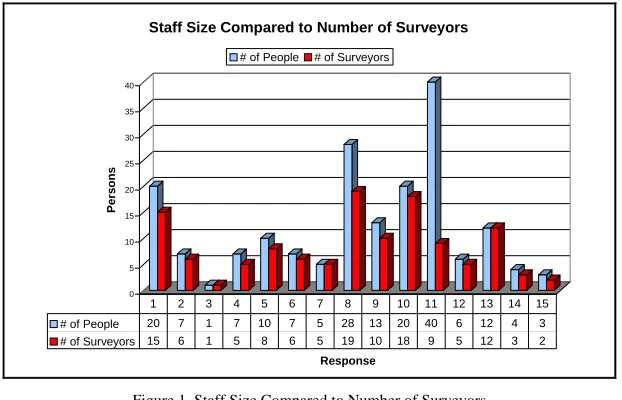
The respondents ranged in size from the single surveyor firm to local offices of large national groups. Comparison of practice size results indicated that as firm size increases so does the ratio of support staff to surveyors, generally in the range of one to three (1 support to 3 surveyors) and approaching one to two. This can be seen in Figure 1 which compares the total number of staff to the number of surveyors.
0 5 10 15 20 25 30 35 40
P
e
rs
ons
Response
Staff Size Compared to Number of Surveyors
# of People # of Surveyors
# of People 20 7 1 7 10 7 5 28 13 20 40 6 12 4 3
# of Surveyors 15 6 1 5 8 6 5 19 10 18 9 5 12 3 2
[image:5.595.150.461.188.388.2]1 2 3 4 5 6 7 8 9 10 11 12 13 14 15
Figure 1 Staff Size Compared to Number of Surveyors
As can be seen from Figure 1 response eleven appears to indicate surveying is one of a number of core activities carried out by this firm, and discussions directly with them confirmed this view. It may be argued that firm eleven should be removed from the analysis because of their size and the multi-disciplinary nature of their business, however it could also be argued that many medium to larger firms are moving to this type of firm composition. The average firm size is approximately 12.2 persons with approximately 8.2 people (68%) working in surveying related activities in the firm.
The first question this research was looking to answer was whether the size of the firm correlates with the use of GIS software. The data collected had two measures for software, being the ranking of software importance and the number of licences held. In total only four firms out of fifteen (27%) respondents had GIS software. There was no obvious correlation between firm size and GIS ownership with a firm of less than 5 staff owning GIS.
Seven firms (47%) ranked the importance of GIS as zero or virtually indicated that they did not believe that it was a necessary or useful component of their business, whilst only 27% ranked GIS software as being important (a rank of 3 or above).
Those firms who ranked GIS at three and above and had a high ratio of non survey staff compare quite dramatically to the others. For those firms already using GIS, the average staff ratio is 0.38:1 or 0.38 non-survey staff for every one survey staff member. The results would appear to indicate that a surveying firm has the potential to take on a GIS system when their staff to surveyor ratio approaches 0.3:1 or greater, which is approximately one non survey staff member per three surveyors.
Firm Size and Range of Surveying Services
The description of surveying services offered by each of the respondents provided no obvious identification of why GIS is more important to one business than another. In general however, those who ranked GIS at three and above in importance also expressed that GIS and spatial datasets are one of the potential growth areas for the firm, away from the traditional cadastral services. From the fifteen responses received, seven firms are providing GIS related spatial services or see these services as part of their future business. One comment by a few of the respondents indicated that some firms are engaged in the management aspects of their clients’ projects and higher level consultative roles that were different to the general responses.
Very few respondents indicated they had people with other professional qualifications in the firm. Interestingly, two of the firms who did have other professionals in the firm also ranked GIS highly as a software tool, indicating that their spread of work was probably greater for the extra specialisations.
When questioned about the likely change in services delivered by their firm, many respondents indicated that GIS and spatial information presentation are expected to grow. Most often this was in addition to maintaining or growing their existing lines of service in the cadastral and engineering areas. The respondents who expressed this view also indicated a changing role for the principal surveyor in the firm, being viewed as more of a spatial data manager with a greater focus on the marketing of new and different products through networking and promotion.
The conclusion from this analysis is a surveying firm with more than ten staff and a staff to surveyor ratio of more than 0.3:1 is capable of delivering an expanded range of management services to their clients. Since this appears to match with the previous analysis for staff size and GIS importance and use, it would appear that the expanded range of services includes GIS and spatial data services.
Digital Base Data
The questionnaire contained a series of questions about the importance of base data, whether they had used base data to value add and from which organisations they sourced this type of data. While base data was ranked at four and above by all respondents, and a majority said they used base data to value add to their products, very few indicated they obtained data from organisations other than those that provide the core cadastral / land title information.
A question on data sharing culture in surveying provided an interesting range of comments related to sources of data. One respondent considered data was being locked away by state and local governments, with restricted public accessibility. Others saw a need for a centralised data facility covering the whole of Australia and freely available search access for surveyors. Intellectual property and royalties for providing this information to the central collection body also featured heavily in responses to this question. In general the responses indicated a lack of trust in both the bodies controlling the information and in the compatibility and reliability of the data. One response clearly encapsulated a position where there needs to be more discussion of the partnership in data and the flow of benefits or advantages to be gained by both the giver and the receiver.
Independently of the questionnaire, an Internet search for surveying data sources indicated that all national and state government bodies that collect spatial data make this available to the public. Examples were found from Geoscience Australia, Queensland Department of Natural Resources, Mines and Energy, Public Sector Mapping Agency, New South Wales Land and Property Information and the ACT Land Information Centre.
Geoscience Australia provides digital data for the whole of Australia in a range of themes, with licensing conditions that allow the creation of derivative products without further payment. Many of the Geoscience Australia digital map products are free if downloaded from the web and where a charge is made the cost is often little more than the cost of reproduction to the digital media. This is in accordance with the Australian Government fundamental spatial dataset pricing policy [OSDM, 2004], which promotes the efficient and effective use of spatial data collected by Commonwealth agencies through making it freely available. The policy recommends no restrictions be imposed on the creation of derivative products from fundamental spatial data.
Similarly, the various state governments in Australia provide a range of digital data covering cadastral and topographic information. In most cases this information is licensed for single use at the published prices, but can be licensed for creation of derivative products upon application and agreement as to the royalties to be paid to the state.
A limited search of the Australian Spatial Data Directory [ANZLIC, 2003] for digital data availability on local government development zoning provided a number of results in many states of Australia for property and other types of zoning. While this data was not available online, the directory contained the contact details for the relevant local government bodies.
What we gained through the questionnaire was a perception that good quality digital data is not readily available to surveyors from the various government agencies. Yet a search of the Internet found that most of these agencies make this information available on a commercial basis and provide licensing for those firms who want to create derivative products. There appears to be minimal impediment to a surveying firm creating digital spatial products by using a range of data sources for their clients and community.
Data Sharing
Data sharing was also seen in a fairly negative sense. Those who said they shared data generally only did so with other professionals, mostly engineers and architects, to meet the requirements of the client's project. A wider data sharing culture was not evidenced from the responses to the specific question posed, with a general concern for intellectual property rights, reasonable payment for use and leadership at the government level.
Again these concerns could be tested by Internet research in the area of copyright. The Copyright Agency Limited (CAL) has addressed the fact that 'survey maps and plans are protected by copyright as they constitute an artistic work, while bearings and distances are protected by copyright as they constitute a literary work' [Copyright Agency Limited, 2003]. CAL is recognised by the Copyright Tribunal as the body authorised to act on behalf of surveyors for the receipt and distribution of royalties.
The area of contention lies with survey products that are completed to meet government land registration and dealing requirements. Governments have relied upon the Copyright Act 1968 provisions that assigned copyright to the government for works created under the direction or control of government. In terms of products completed for a client but required for land registration and dealing, this reliance is being tested through the Copyright Tribunal by CAL. It is understood the Queensland Government agreed in 2001 to pay royalties to surveyors for the copying of maps and plans other than for the services of the State Government [ISA QLD, 2004]. An action is currently in progress for a similar agreement with the NSW Government [Copyright Agency Limited, 2003].
The other possible area of concern is the ownership of copyright on client created products. This is an area where the surveyor is in full control, since they are presumed to own the copyright for every situation except the implied licence to use which is given to the client. The surveyor should therefore have an explicit agreement whenever they assign their copyright ownership to someone else.
The land surveyors practice has traditionally been concerned with surveys that would ultimately come into the possession of government bodies, and it is understandable that data sharing in an environment that compulsorily re-assigned a surveyors copyright to the government would not be a priority. For many surveyors this type of work is now a less significant part of their business, but copyright issues may still be overlooked in presenting products to clients and their other professional service providers.
DISCUSSION
It is recognised that the size of the sample in the study is small and limited to the ACT and NSW, however it is suggested that some indicative trends are evident. The results of the questionnaire have shown that GIS is currently not a pervasive technology within the surveying industry, with a low percentage of firms having GIS capability and most firms not rating GIS as an important technology for their business. The industry appears to be in the early adoption stages of technology diffusion described by Onsrud & Pinto [1991] when it comes to the utilisation of GIS. This is further supported by Fenwick & Mayr [2002] who provides examples of the successful use of a single GIS product by some early adopter firms and shows that they have embraced GIS for more than specific client products.
Given the private survey practice is today in the early stages of GIS adoption and diffusion we can examine experiences from the introduction of GIS in state and local government organisations, which is described by McDougall et al. [2002] as having a history of inconsistent development over 25 years but has now reached the point of being integral to operations of the organisation. Over this timeframe progress in local government was often driven by a small number of individuals, subject to changes in priority for financing and implemented initially to suit the needs of a single section or specific operation. Many local government bodies have finally reached the point where GIS is widely integrated with the other local government systems, since many transactions have a spatial component allowing GIS to be the portal to these business systems. The history of GIS implementation in local government can therefore provide a casebook of experiences for the private survey firm to fully consider the benefits of implementing a GIS and the most suitable approach for their organisational structures.
GIS technology is seen as revolutionary [Godschalk & McMahon, 1992, cited in Budic, 1994] and Sieber [2000] states that 'During the dynamic process of any innovation, an organisation adapts the technology to suit its needs; however, the organisation also is modified by the technology' [pg 16]. For a surveying organisation this means the firm must not only fit GIS to its current operations but look to change its business to maximise the benefit of the technology. This is the revolutionary aspect of GIS, where the business will to some extent be destabilised during the process of adopting GIS as an operating paradigm in the business.
GIS / SDI model proposed by Chan & Williamson [1999] since it integrates data across the business such that all datasets can be shared.
A number of respondents to the questionnaire nominated GIS and spatial technologies as likely growth areas in their business, commonly as adjuncts to their current business. This would indicate GIS use will be in a project specific model with these firms, following the path already pursued by local government, as referenced by McDougall et al. [2002]. To move beyond this level of use will require a vision for GIS in the organisation that recognises the benefits of improved data, leading to operational effectiveness, as well as a desire to innovate with new products and approaches [Chan & Williamson, 1996; Sieber, 2000; Budic, 1994]. Justification will need to consider both the tangible and intangible benefits and costs of GIS implementation, and business operations must be able to supply the necessary financial resources to take the implementation project through to the point of achieving the identified benefits.
Numerous comments on the questionnaire indicated there is already an impact on the profession from the growth in a wide range of spatial services outside of traditional surveying. Many respondents noted an inability to attract suitably qualified and experienced people to their firm to undertake land surveying projects. Williamson [1997] appears to have accurately predicted this situation with the observation that the traditional cadastral surveying base, which is so often seen as an indicator of the health of the profession, has been in decline since the 1980's, with 30 percent or less of Australian surveying graduates going on to cadastral registration nationally in the 1990's. Over the same time period Williamson [1997] notes that surveying graduate numbers in Australia have steadily fallen from a peak of over two hundred per year to a predicted one hundred per year in the early part of the twenty first century.
Williamson [1997] also discusses the changes that have taken place in surveying education and the fact that while the basic science component and the cadastre, land and environmental management and land development have remained at a constant level of curriculum content, the measurement sciences have been significantly reduced to allow for growth in information technology and GIS. This provides surveying graduates with a broader range of career options in the spatial sciences without the necessity for cadastral registration.
While cadastral information is seen as an integral part of any SDI, there is no evidence that the entire cadastral industry has been included in its ongoing maintenance through any shift away from the organisation specific constraints common with many government bodies. The questionnaire showed that private surveyors are not knowingly involved with any SDI initiative, yet this must occur in the future as those organisations currently collecting spatial information discover the need to keep this information updated in increasingly shorter timeframes and by necessity, partner with the industry to achieve this result.
While there appears to be no shortage of work for land surveyors, the demand may soon plateau at a level that matches the number of available surveyors simply because some projects cannot be undertaken. In this circumstance clients will look for alternative methods to achieve their outcomes, especially if the use of a surveyor is not required by government regulation. This may be a dangerous outcome for the profession, as clients find alternatives to using a surveyor they may decide to do all their non-regulated work that way.
While GIS is a technical tool, when used in its full organisational enabling form it will create many organisational and cultural issues. In its widest sense, bringing information products to the wider local community will now demand the use of the Internet as a delivery mechanism. As described by Coleman et al. [1997] any notion of control is largely irrelevant with the Internet and this can be very unsettling to an organisation already using traditional processes for spatial data distribution. This is also the case with the development and implementation of standards, which often take years under traditional structures yet can be completed often in less than a year within the Internet community. For the surveyor, the Internet will open up access to their products to many new users, including potentially to international scrutiny. Coleman et al. [1997] conclude that additional overheads will be incurred through requiring additional resources and 'While the new mix of system and human resource requirements will become clear over the longer term, the organisation must be able to withstand a period where the imbalance between these two will affect its ability to service customers effectively' [pg 7]. This is the implementation effect of introducing a revolutionary technology.
Data is also an implementation issue when considering GIS. The ability to identity a specific type or theme of data and then establish from where it can be acquired is considered by Pienaar & van Brakel [1999] to be one of data acquisitions 'greatest operational problems and costs' [pg 365]. For the surveyor to engage in data sharing they must become spatial data managers, adhering to industry standards and providing consistent and complete metadata about the information they are contributing. To undertake this recognises the value and overheads of data custodianship. Many respondents to the questionnaire indicated their principal surveyors were already required to be data managers.
data and value adding services will be competing in the wider employment marketplace for appropriately skilled individuals. To implement this move in business services will require an evaluation of the skills needed by the business and the development of strategies to achieve the results. Given the reduction in graduates previously discussed and the broad market for their skills, this may be the most difficult constraint to overcome. While in the short term training strategies and revised employment conditions may fill the gap, the long term solution is to have more people graduating into the profession. The implementation issue is therefore one for the spatial industry to demonstrate continuing relevance to society and foster the attractiveness of a spatial career.
CONCLUSIONS
The aim of this research was to investigate the feasibility of the private survey practice providing value added spatial data services to their clients and the local community, thereby acting as a local spatial data custodian. While the size of the sample is small the study found that diffusion of GIS technologies is still in the early stages with surveying firms. It appears that GIS is one of a number of product toolboxes rather than part of the operation of the individual firm. Many surveying firms already have the technical infrastructure, including GIS software and people experienced with its use, but provide limited value added services to their clients. There is evidence of a growing community demand for digital data in GIS form and therefore a market that surveyors can satisfy.
For a firm to utilise GIS for value added products, this research indicates that a staff structure that contains at least one non surveyor for each three surveyors may be required. This is most likely to be achievable as a firm approaches ten staff, since this appears to allow at least one person to be dedicated to product presentation and researching improvements in product presentation using GIS. Access to digital data was described by many respondents as a problem, but the research demonstrated that a very wide range of data is available for use by the firm and can be licensed for creation of derivative products. The only constraint with digital data is the ability to find a source of appropriate data for the firm's needs and the provision of finance for the necessary licences.
The major software packages in use by the spatial industry provide for data interoperability without significant effort and the industry is increasingly consolidating on some accepted standards for data interchange that may facilitate this even further. However, GIS is a revolutionary technology and will precipitate change in the organisation and the people who work in the organisation.
REFERENCES
ANZLIC. (2003), Australian Spatial Data Directory, http://www.asdd.ga.gov.au/asdd, Geoscience Australia, Web site accessed September 8, 2004.
Budic, Z. D. (1994), “Effectiveness of Geographic Information Systems in Local Planning”, Journal of the American Planning Association, 60(2), 244-63.
Campbell, H., & Masser, I. f. (1995), GIS and Organisations. London: Taylor & Francis Ltd.
Chan, T. O., & Williamson, I. P. (1999), “Spatial Data Infrastructure Management: Lessons from Corporate GIS Development”, 27th Annual Conference of AURISA, As seen at
http://www.sli.unimelb.edu.au/research/SDI_research/publications/publisdi.php, Web site accessed March 18, 2004.
Chan, T. O. & Williamson, I. P. (1996), “A Holistic Cost-Benefit Approach to Justifying Organisation-wide GIS”,
Regional Conference on "Managing Geographic Information Systems for Success", Melbourne, As seen at http://www.sli.unimelb.edu.au/research/SDI_research/publications/publisdi.php, Web site accessed March 18, 2004
Coleman, D., McLaughilin, J. & Nichols, S. f. (1997), “Building a Spatial Data Infrastructure”, Proceedings of the 64th Permanent Congress Meeting of FIG, Singapore, As seen at
Http://www.digitalearth.net.cn/GISConference/BuildingASpatialDataInfrastructure.pdf, Web site accessed April 6, 2004.
Copyright Agency Limited. (2003), “Surveyors and Copyright”, Country Surveyors Conference October 2003, As seen at http://www.copyright.com.au/surveyors_speaking%20notes.htm, Web site accessed September 9 2004. Durgin, P. f. (1990), “Surveyors and GIS”, In Onsrud, Harlan J; Cook, David W, Geographic and Land
Information Systems for Practicing Surveyors, USA: American Congress on Surveying and Mapping. Fenwich, R. & Mayr, W. f. (2002), “GIS and the Consulting Surveyor”, In Hocking, David, Business Practice
Manual, Http://www.spatial.org.au/sitdp/documents/ACF18DC.pdf, Association of Consulting Surveyors Australia.
Harvey, F. f. (2000), Potentials and Pitfalls for Vertical Integration for the NSDI: Final report of a Survey of Local Government Perspectives, Lexington Kentucky: University of Kentucky.
Harvey, F. f. (2003), “Developing Geographic Information Infrastructures for Local Government: the Role of Trust”, Canadian Geographer, 47(1), 28-36.
ISA QLD. (2004), Australian Copyright Trust
http://www.isaqld.org.au/Public/News/ViewArticle.asp?ArticleID=16, Web site accessed September 8, 2004. Masser, I. f. (1997), “Data Integration Research: Overview and Future Prospects”, Geographic Information
Research at the Millennium: GISDATA Final Conference, France: European Science Foundation. McDougall, K., Rajabifard, A., & Williamson, I. P. (2002), “From Little Things Big Things Grow: Building the
SDI from Local Government Up”, Joint AURISA and Institution of Surveyors Conference, As seen at http://www.sli.unimelb.edu.au/research/SDI_research/publications/publisdi.php, Web site accessed March 18, 2004.
de Montalvo, U. W. (2003), “In Search of Rigorous Models for Policy Oriented Research: A Behavioural Approach to Spatial Data Sharing”, URISA Journal, 15(1), 19-28.
OSDM. (2004), Australian Government fundamental spatial dataset pricing policy, http:\\www.osdm.gov.au, Australian Government Office of Spatial Data Management, Revision date 24 March 2004.
Onsrud, H. & Pinto, J. K. (1991), Diffusion of Geographic Information Innovations,
Http://www.spatial.maine.edu/~onsrud/pubs/GIS_Diffusion_.html, Web site accessed April 6, 2004. Pienaar, M. & van Brakel, P. f. (1999), “The Changing Face of Geographic Information on the Web: a
Breakthrough in Spatial Data Sharing”, The Electronic Library, 17(6).
Sensis. (2004), Yellowpages Search, http://www.yellowpages.com.au, Web site accessed August 1, 2004. Sieber, R. E. (2000), “GIS Implementation in the Grassroots”, URISA Journal, 12(1).
Warnest, M., McDougall, K., Rajabiford, A. et al. (2003), “Local and State-Based Collaboration: The Key to Unlocking the Potential of SDI”, Spatial Sciences 2003, As seen at
http://www.sli.unimelb.edu.au/research/SDI_research/publications/publisdi.php, Web site accessed March 18, 2004.
Williamson, I. P. (1997), “The Future of the Surveying profession - An Australian Perspective”, Geomatica, 51(4), As seen at http://www.sli.unimelb.edu.au/research/SDI_research/publications/publisdi.php.