Red devils and white men
127
0
0
Full text
(2) PART II. ________________________________________ THE STORI BLO MEINLAN. Plate 4: Harbour of Somerset, Qld September 21st 1872: Watercolour by unknown artist looking out towards Albany Island. (Courtesy of the Mitchell Library, NSW. Original held in the Small Picture Collection DG*D3 folio2). 70.
(3) Chapter 5: ________________________________________ DISKAINTAIM 5.1 The Fourth Coming We watched the marakai as she rolled up her swag and gathered her belongings. Any minute now and she would realise they were missing! Yes - There now. It wasn’t the same if they didn’t feel the loss. There was still a chance though that we would have to give them up. She was with two men of the people. But we did not recognize them and they did not appear to know us. The rules were that unless they spoke the words we could keep the prize. We were going to win, we could feel it! Last night we had crowded around to listen, just outside the light of their campfire. The new tongue that the marakai spoke was harsh to our ears and hard to understand. We learnt that she had come to study the land, our place that they call Somerset. She has come to learn and observe but she did not see us as we crowded close to claim our prize. We had no doubt that she would be like all marakai, arrogant and deaf to the language of the land. None of them saw us take her knife and shiny silver pen. I had come to Cape York initially in 1986, to assist a friend on a project (Greer 1995). As a result of that first visit, I began my own research. It was my second visit to Cape York, and the first joint field expedition that Shelley Greer and I had undertaken. Joint survey had seemed to be an ideal way of maximising results. At that time in the early stages of her research she was searching for the. elusive. ideal. site,. which. might. provide. evidence. for. ‘intensification’ in Cape York (cf. Lourandos 1983,1997), and I was looking for historical sites that were witness to European settlement and exploitation of northern Cape York Peninsula.. 71.
(4) Plate 5. Watercolour by unknown artist entitled ‘Cape York, Northern Point of Australia’ September 24th 1872. Courtesy of the Mitchell Library, NSW. Original held in the Small Picture Collection DG*D3 folio 2).. At this time I still felt alien in the landscape. The rangers, Jackson Sailor and Aaron Sebasio (employed by the then Archaeology Branch, DCS) were assisting us. We had just had a wearying day crossing through the rough “boxing seas” at the mouth of Albany Passage just on dusk. The waves hit the dinghy at right angles and it pitched alarmingly. Once through the entrance, the waters were calmer. We were aiming for Somerset as Jackson had said there was fresh water available in an old well. The boat did not have lights of course and it was dark by the time we made it to Somerset Bay. Aaron leaned over the front of the boat with a small hand torch and guided Jackson through the coral reef. I shivered with visions of crocodile jaws enveloping Aaron as he hung precariously over the boat. After a final nerve-wracking wade through shallow water in the dark, we made the beach. We were wet, tired, sunburnt Shelley and I, and plastered with salt, but at least we had arrived without accident.. Somerset appeared an overgrown and sinister place at night. The scrub encroached right down to the sand, and mangroves fringed either end of the small crescent of beach. The wind washed a chilly hand across my shoulders and I jumped as a small branch scratched my sunburnt neck and snagged my hair. Shelley responded with nervous laughter. It was the sort of place where 72.
(5) you knew it would be disastrous to let your imagination run wild. To camouflage our lack of valour we all played cards by firelight, but I noticed that both Rangers kept their rifles close to hand.. The men cheated at cards but it took Shelley and I a long while to realise it, after which loud protestations ensued. Finally, we slept. Our sleep was marred by the soft hand of the wind across our faces and the small skittering noises of harmless animals. At least I hoped they were harmless!. Later we were to hear the history of this place, and the dangers that lurk in parts of the scrub, and I marvelled in hindsight that the Rangers had suggested that we stay there. But for this stay at least we were largely in blissful ignorance of the stories of power and conquest, brutality and beauty that characterise Somerset.. In the morning the world looked decidedly different. The landscape now seen in daylight for the first time looked picture-postcard romantic. Coconut palms fringed the white sand, which now extended further as the tide had gone out. Before packing up we inspected the graves, which remain at Somerset, including that of Frank Jardine. We looked at the well and the scant signs that were all that remained of one man's dream and the endless nightmare for the Gudang and Kaurareg peoples.. It was not until we were about to get into the boat that I realised that my penknife (a gift from a friend) and my silver Parker pen had been lost. I had had them the night before. Perhaps I had dropped them in the saltwater as I jumped out of the boat, or perhaps I had left them under the tree where we had camped. Although I looked, I could not find them.. 73.
(6) 5.2 Experiences with Short Men and Red Devils A week later back in the village of Cowal Creek (now Injinoo) I complained of the loss to my mother’s sister, Mrs Sagigi (Mumma Elaine). Shelley and I had both been adopted by Meun Lifu (Daddy Shorty) and his wife Clara (Mumma Clae) and we benefited not only from their considerable knowledge of the area but also from that of their kin who generously acknowledged this relationship. Mrs Sagigi explained to me: Dem Bulla Bulla dem short man, long ontop lo land ee alright ee make head go ron but dem wild one lo mangrove [um de red one (daddy shorty)] long arse, all red one, all dem shell ee stik lo arse. Dem all wild one, all red one blo mangarro. Dem alup shell, any kind shell outside lo sea. Em sit ontop lo shell but dem wild. Dem ontop lo scrub ee alright! Ip all look you got something nice or some all fancy ee dat thing lo you, something can cum just from hand blo you, if you gat watch and dey like ee watch and then you.... I commented that perhaps this is what had happened to my pocket knife that I lost when we camped at Somerset. ee no gad ah? That one emm kin! Dat one steal em! Dat Somerset dat one! You should aske em back. Aske em!. Mrs Sagigi went on to describe the tricks that the short men get up to: Them short man ee gad here too inside dem scrub. When you go rond one place ah dere lo scrub you sabbee its dem that makke your head no good. You marke dis place you go you walk go den yu come out here again. Mepla bin dis kind before.. She then described several experiences at Muri (Mt Adolphus Island see Figure 2 and Plate 7). The full transcript of her account is included in Appendix E. On one occasion she had gone there with her husband. While he collected clams just off shore in the dinghy she had gone to collect oysters. An em I think em bin pigget to sokee talk or something like that. Dempla listen too! Em go wannem ere dinghy - and me I start por crackee oyster, I silly por dem oyster, kum straight in of that pointed hill, hill frontside, crakee oyster insidelo mangrove. I pigget now, I whistle, I talk myself and den whene wane elp I talk too rough. I got big mouth, I go EHEH! I go like dat! An I think dempla listen they think ‘ Mmm dis gel go too far!’ You know anyway, I bin listen whisper! Asa man talking whisper kum and den my heart ee jump now! I mutta stop now I no wanne move! Ya gah! I bin 74.
(7) whistle then sing. Sing go go and when that sing bin stop that frightened feeling now bin kum long me. I listen whisper! And them some stone ee roll asa this kind straight, as if ee can kum and hit my head! This oyster i bin bust him I go raun this kind and kum back. Ee got nother one I bin bust em bust em leabe him. I bin take dis one here. An I kum back I kum back I go start em from begin kum rond this kind again. That big stone ee roll, I no bother for look kum ontap only wait. Ee hitee head blo me! Yeah I bin get that mark and I bin look blood! Two same time! I bin holler I no care only I wait em what time stone bin hittee mee but nothing stone bin fall down. When em bin heaya em bin sabbee straight away, em bin kum start ee engine ”kum kum ontap” he broke his shirt tight em long that wannem ee put that shirt raun em say mutta go.. As soon as the stoning began both Mrs Sagigi and her husband knew that it was the short red devils and they also realised that they were transgressing in that they had not ‘called out’ or ‘soked tok’ to ask permission to take the resources of the area. To add further insult Mrs Sagigi had forgotten herself to the extent that she whistled and called out drawing undue attention to herself.. Comparing the experiences of Injinoo people with the spirit occupants of the landscape, it was clear that there is a consistency of experience and descriptions about the beings themselves, the places in the landscape that they occupy or are likely to occupy and the behaviour on encountering humans. Red devils are described as short and red with scaly ‘arses’. They occupy stony coastlines, concealed by mangroves at specific ‘magic’ places such as Muri Island (Mt Adolphus Island see Figure 2 and Plate7). Unlike short people who are mischievous and uncaring rather than malevolent, they are usually hostile to humans and delight in hurting them when they transgress hence the stoning of Mrs Sagigi at Muri (Appendix E).. On the other hand the short people who live in the scrub are more mischievous than cruel. They like to steal bright, pretty things and take a delight in making people disoriented and confused. This of course can have serious consequences if one gets lost in the scrub and is unable to find one’s way out. However in all such cases that 75.
(8) were recounted to me the short people in the end relented (or perhaps got bored) and allowed the lost person to suddenly see the way out.. Stories such as these are everyday occurrences in the interaction of people and the sometimes, dangerous landscapes of Cape York and the Torres Strait. Some places such as the scrub around Lockerbie and Somerset are known to be the province of short people and others such as Muri (Mt Adolphus Island) and the coastal rocky shore around from Somerset are known to be even more dangerous and guarded by red devils. Language or langus is a powerful tool in securing protection in these landscapes (refer Chapter 4). There are several rules that apply to ensure safe passage through these landscapes.. Plate 6: Mrs Ethel Sagigi (Mumma Elaine) 76.
(9) Plate 7: Muri –(Mt Adolphus Island) is a dangerous place and is occupied by red devils. Ideally, one should be accompanied by a language speaker for that particular country who should call out, sokee tok, to announce or ask permission to carry out the activity. One should never whistle, as this is likely to draw you to the notice of such beings. You should not call out or shout or generally act in a raucous manner as this may anger red devils who will often retaliate by stoning you or causing accidents or bad luck. You should not swear, particularly at the bush or other elements of the landscape. It is also offensive to these beings to be too greedy and deplete resources and it is advisable to leave offerings for example if fishing leave part of ones catch.. Interestingly, since most people know these rules, there are clearly many cases where for one reason or another they are broken, otherwise such stories of misadventure would not be common. Sometimes, this is because people desire the resources of the 77.
(10) place and either do not have access to a language speaker or they are willing to risk the consequences. In other cases, it is because a long time may have passed since people visited a place and they may have forgotten that it is dangerous. At such times the devils and short people like to take advantage of their carelessness. There is some suggestion that if you are quiet and get about your business and do not go directly onto the land around places like Muri then you are often tolerated by the red devils or they choose not to notice your presence. However, to be loud and raucous is to press your luck. Hence Mrs Saiga’s conclusion that when she called out loudly the red devils must have thought ‘ee dis gel go too far!’ (Hey this girl has gone to far!).. When younger people recount such experiences, it is often used by older people as a teaching opportunity. There are also times when new dangerous places are discovered or rediscovered and once again the experience and the recognition of what this signifies is the evidence for its identification as dangerous. Beings similar to these are known to inhabit the Aboriginal landscape in other parts of Australia and many ethnographers recorded stories of ‘short people’ or what they referred to as ‘pygmy tribes’ (see for example Winterbotham 1982:97 which is a transcript of interviews with an Aboriginal informant in the 1950’s).. 5.3. From Devils to the Mundane-Northern Cape York Communities Today. At the time of my first visit the communities clustered at the tip of Cape York were in transition. There are five communities in northernmost Cape York (Figure 2). Of these, the oldest is Injinoo (formerly Cowal Creek), which was established around the first half of the twentieth century, probably around 1915 (see section 5.4) and comprised remnants of the local tribes, who had not been dispersed, massacred or lost to illness. After World War II the Queensland Government had moved to form the Northern Peninsula Area (NPA) Reserve consisting of around 39,462 78.
(11) hectares, and since the late 1940s, four other communities had been established in the area (McIntyre & Greer 1994:5.1-5.26). At the time of the commencement of this research the communities had been handed back some control of their land through the Queensland Deed of Grant in Trust (DOGIT) system and were asserting increasing autonomy over their day-to-day operations through local community councils. Economic and social growth, however, were still heavily influenced by Government policy and strictures. For example, it was not possible for a community to establish a commercial operation except a beer canteen, an irony that did not escape many Aboriginal and Islander people (Daniel Ropeyarn pers comm. 1989; David Byrne pers comm. 1989).. Plate 8: The tip of Cape York Peninsula. 79.
(12) 5.3.1 Changing Government Policies Aboriginal people in Queensland as elsewhere in Australia, have long. been. buffeted. by. changing. government. policies.. In. Queensland however, the period of direct governmental control lasted significantly longer than in the southern states. Forced mass removals of Aboriginal people were occurring well into the lifetimes of today’s middle aged Australians, with Port Stewart people removed in 1958 and those from Old Mapoon moved in 1963.. Greer (1995:69) has summarised the work of others on the State governments policies and legislation relating to Aboriginal people in Queensland but for those unfamiliar with this history, Anderson’s (1981:55) four historical periods are a useful overview. They are: 1.. 1830 –1872: characterised by the dispossession of Aboriginal people through violence and the use of Native Police; 2. 1873 –1896: a period in which experiments in the setting up of reserves (both private and government sponsored were undertaken; 3. 1897 –1956: the beginnings of a legislative framework and life ‘under the Act’; characterised by so-called ‘Protectionist’ policies; 4. 1957- early 1980’s: the period characterised by the policies of “Assimilation” (Anderson cited in Greer 1995:69).. In 1895 Archibald Meston completed a survey of Aboriginal settlements. in. Queensland. regarding the management. and. presented. his. conclusions. of the Aboriginal ‘problem’ in. Queensland to the government (Meston 1895). Meston proposed that where Aboriginal people were not being adversely affected by white settlement they should be left alone to continue their lives, but where they were being adversely affected or exploited they should be relocated to areas of land set aside for them. He also proposed that Aboriginal people generally should be compensated for the loss of land and amenity they have suffered through white settlement. Sharp (1992:27) misreads Meston’s comments and has assumed that he conformed to the prevailing opinion that Aboriginal. 80.
(13) people were a ‘dying race’ and therefore only a temporary problem for the colony’s administrators.. The Reserve system lasted in north Queensland well into the 1980s ending officially, but not in practice, in 1985 with the ‘handback’ of land under Deed of Grant in Trust by the Queensland Government in Cape York and the Torres Strait. However during the handback ceremonies in the Cape York and Torres Strait communities, the then Premier, Joh Bjelke-Peterson handed back empty envelopes in some cases and unsigned photocopies in others. Life following the supposed handback continued unchanged for a number of years with endless talk about ‘the department’ (that is the State Government Department administering the reserves which at that time was DCS) pulling out of the day to day management of the communities.. In 1949, the Queensland government formed the Northern Peninsula Area, a reserve of some 39,462 hectares that would eventually encompass the communities of Injinoo, Umagico, Bamaga, New Mapoon and Seisia. The reserve was administered and run by Queensland government staff based at Bamaga under the at times despotic rule of the 'Manager'. During the history of the reserve the department responsible for its management changed its name from the Department of Native Affairs (DNA), to the Department of Community Services (DCS) and finally to the Department of Family Services and Aboriginal and Islander Affairs (DFSAIA). Aboriginal people today tend to use these names interchangeably and in reality these were name changes only with the same staff being employed regardless of the department name. Each of the smaller communities, except Seisia (which the Department steadfastly refused to acknowledge as a community in its own right), had a community council and representatives from each of these formed the Combined Northern Peninsula Area Council, which was nominally the voice of local people in administrative matters. Bamaga became the focus of government 81.
(14) intervention, with government offices, schools, housing, a farm, a sawmill and other light 'industries' located here. This illustrates the Queensland Government’s long-standing favouritism of Island people. over. Aboriginal. people.. Today. all. residences. for. government employed non-Aboriginal people are located here.. The one common factor in a review of government management of the reserves is the degree of control and intervention over adult lives, exerted by people who often had limited skills and expertise. One policy recommended that people should be herded together as there was more efficiency in managing people in groups. Within the confined area of the NPA, it was decided that people should decentralise onto farms and smallholdings and develop primary industries for the reserves. This was when areas such as Blue Valley (see Figure 2) in the NPA were cleared and settled. Such policies had significant environmental impacts (to the extent that these areas are still visible in aerial photos today some 30-40 years later) in addition to their obvious social impacts. These enterprises were doomed from the start, not being based on information such as soil capability, agricultural knowledge or experience in animal husbandry or business management. Once they failed, people were forced out of their houses and back to the villages. In most cases all structures relating to these enterprises were bulldozed to prevent people returning to live there. This physical erasure of cultural heritage was a consistent form of government control exerted over Aboriginal people in Cape York and a direct response to the most common form of indigenous rebellion i.e passive resistance. Hence, properties such as Somerset and Mapoon Mission were destroyed by the Queensland government without regard for their heritage value, after Aboriginal people resisted efforts by the government to persuade or coerce them to leave (McIntyre 1999).. All five of these communities in this most northern area are bound together by familial ties and intermarriage. However, different 82.
(15) cultural. backgrounds. governmental. and. favouritism,. experience,. resulted. in. the. exacerbated emergence. by of. antagonisms and grievances. Today, while the spectre of the ‘Manager’ has faded and there is generally greater movement between communities, old tensions and suspicions sometimes arise to complicate matters. Since the end of the reserve system there has been greater movement between these communities and their southern neighbours and both kinship and political ties have been established and reinforced. In the following pages I provide a brief introduction to each of the NPA communities and their southern neighbours of Weipa, Old Mapoon, Lockhart River and Aurukun.. Plate 9: Reclaiming Cape York - The first Cape York Land Summit Inaugural meeting of the Cape York Land Council.. 83.
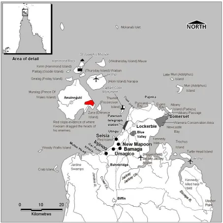
(16) Figure 2: Locational Map Northern Peninsula Area. 84.
(17) 5.4 Marakai callem Cowal Creek but itse Injinoo The Community, now known as Injinoo Aboriginal Community, changed its name from Cowal Creek Community officially in 1988. Injinoo is a local word meaning ‘Small River’ and refers to the creek on which the settlement is located. The renaming was a political act through which the community sought to reclaim and redefine itself as it emerged from the reserve period. The assumption was that ‘Cowal’ had been a white imposed name, however it is likely that in fact Cowal was a European spelling of an indigenous word as local Aboriginal and Islander people always pronounced it ‘Kohl’. In fact they distinguished themselves from white people saying ‘Marakai (white people) callem Cow-wal Creek’.. Cowal Creek is an historical anomaly, as it was not established as a mission or government reserve. In 1918 the report of the Chief Protector of Aboriginals referred to a small settlement that had been established at Small River (Cowal creek) by the remnants of the Red Island and Seven River tribes somewhere around 1915. Bleakly (1961:157) notes that people at Cowal Creek supported themselves by fishing and gardening and that the Chief Protector had decided to encourage this self–help by providing advice and some equipment but leaving the management of the community to an elected council. As this was not a government reserve or church mission there is very little archival information relating to it. In 1924 a Torres Strait Islander teacher was sent to Cowal Creek (Chief Protectors Report 1924). At some point, the Anglican diocese of Carpentaria sent a trained Islander Deacon there. In 1936 the Chief Protector of Aboriginals commented in a letter to the Under Secretary It must be pointed out that the natives of this settlement at Cowal Creek are a very primitive type, being the remnants of the old Seven Rivers and Red Island tribes, who formed this voluntary native village, and are conducting the affairs of their little community with no other supervision than a Torres Strait Island Native teacher (QSA A/3866 1936/ 9033).. 85.
(18) A commonly told local story maintains that 6 tribes of the area in northern Cape York came together and decided that they should settle down and form a community if they were to survive the effects of European invasion. These ‘tribes’ were the Seven River, McDonnell River, Red Island Point, Cairn Cross, Somerset and Whitesand people (pers.comm. David Byrne 1989). Some people amongst the most northern of these people chose rather to join their Kaurareg neighbours and relatives and went to Horne Island and were later removed to Hammond Island (Figure 2) and then Kubin on Moa Island. Thus strong links remain today between Injinoo and the Kaurareg and in particular people from Kubin. While Cowal Creek was not officially formed via government intervention there is clear evidence that not all people came in voluntarily. For instance, the account told by McDonnell River people of their ‘calling in’ is not quite so peaceful. Alec Whitesand, the Aboriginal man credited with drawing the tribes together, on this occasion was accompanied by police with guns (Goody Massey Tape # 1992/1). Actually the establishment of Cowal Creek with all 6 tribal groups must have occurred in stages. Bleakley records that in 1918 only the Red Island and Seven River people were present at Injinoo (Report of the Chief Protector of Aboriginals 1919). Alec Whitesand is reported to have been a Wuthathi man and unlikely to have been the original founder of Injinoo as he is likely to have settled at Cowal Creek sometime after it was established. The McDonnell River people who were brought in by Alec Whitesand were the last to be relocated to Cowal Creek, probably during the 1930’s.. Injinoo today is a result of this alliance between the 6 groups. Mr Wilfred Bowie (now deceased) recalled to me how the village at first consisted of separate clusters of bark houses. Each cluster was comprised of a single traditional group. The original village was built on the sand in the area now known as the lookout or camping ground but was later moved back to firmer ground. The occasional 86.
(19) concrete stump foundation can still be seen towards the rear of the camping ground area.. The early years in Cowal Creek would not have been easy with people living so close to groups that they would not have previously had daily contact with. Interactions including marriage seem to have continued to follow traditional alliance patterns and to some extent this can sometimes be detected in the modern Injinoo. People were to some extent suspicious of other groups and hence more comfortable living in close proximity to their own people (Bowie pers.com 1989). Tensions must have run high at times and as Wilfred Bowie (pers comm 1989) remarked ‘puri puri let fly’ [black magic was rife]. It is a testament to the people of Cowal Creek that despite this they managed to forge a community and a unique identity that continues today.. The fact that Cowal Creek was not a government station (until after World War II when it became part of the area managed as the Northern Peninsula Area Reserve) means that there is little archival. information. available. about. the. village. and. its. development. The only information in government records are passing references in correspondence based on visits by the Chief Protector of Aboriginals or other official visitors. Despite having a government funded Torres Strait Islander teacher in the village, detailed records relating to the school and its operation at Cowal Creek do not appear to have been kept. It is likely that many of these records were kept locally at Thursday Island and have since been lost. For instance there is not a complete record of annual school supply requisites for the school although one or two can be found in QSA A/15996 (e.g Dec 1941/ 53/40). Where documentary evidence does exist it is often of a dubious nature representing as it does only fragments of debates or conversations. For example a newspaper article in 1936 quoted a Professor Archibald Watson as saying that ‘Cowal Creek should be wiped out as a pest hole...it 87.
(20) can never be made a healthy place.’ He describes the place as follows The soil was chocolate brown sand made dark and malodorous by decomposed seaweed and other vegetable matter. The youngsters sat down and slept on this. It was no wonder under such conditions that their teeth were bad, their tonsils swollen and there bones were getting soft (QSA A/3866/9033. Courier Mail Bribane:1936).. It is hard to believe that the Professor was actually describing the village of Cowal Creek, which at that time was located on the white sand at the mouth of the river. The Chief Protector of Aboriginals at the time, J.W Bleakley, vehemently denied the allegations that conditions at Cowal Creek were unhealthy. He pointed out that all cottages at Cowal Creek (which had been built by the Aboriginal people themselves) were raised on stumps, and set in clean sand with fresh running water nearby. He also went on to protest the Professor’s claims that half caste Aboriginal girls at Cowal Creek were in ‘moral’ danger and forced to live with ‘blacks’ when they should be ‘put in their right place amongst the whites, where their fathers live’ (QSA A/3866/9033:1936). Sometime in the late 1960’s after the Department of Native Affairs had subsumed Cowal Creek into the Northern Peninsula Area Reserve, the village was moved back from the beach on to the red dirt and the old village was demolished (this area is now the camping ground or ‘Injinoo lookout’ as it is known). At the time of my fieldwork Injinoo was undergoing rapid change. The village currently has approximately 490 residents a high proportion of who are children. Housing standards have improved dramatically and substantial housing construction works have been undertaken over the past 5-6 years and the community infrastructure established over this brief period (i.e. since 1986) includes a large community hall, air conditioned council office and broadcasting station (BRACS), a large vehicle workshop, women’s centre and child minding facility, a modern medical clinic, and a primary school. The re-establishment of a school has been one of the community’s great. achievements.. The. Cowal. Creek. school,. originally 88.
(21) commenced after petition from the Aboriginal people at the settlement had been closed down by the Department of Native Affairs once they assumed management of the reserve. Injinoo has a local female Anglican Deacon (the first female indigenous deacon ordained in the Anglican Church) and local indigenous headmaster at the primary school.. The end of World War II and the withdrawal of troops from the region heralded a new era of government control over the lives of Aboriginal people in northern Cape York. The government began to encourage and coerce communities to resettle in what was to become the NPA. Those non-indigenous people who had returned to the area were soon to find their leases resumed to enable the establishment of the NPA Reserve. For example Stan Holland had in 1949 taken a 30 year lease over a pastoral holding at Cody Hill (not far his home at Red Island Point). This lease was resumed on 23/3/1966 for ‘Departmental purposes’ (QSA:DUP A/47706: Cody Hill Register Entry). McLaren and Graham’s 20 year lease on Utingu had already expired in 1934 and Frank Lascelles Jardine’s lease over Somerset which had following his death, been transferred. to. Hew. Cholmondely. Jardine. (transferred. on. 26/5/1920), had expired in 1934 (QSA: LAN P489). Cowal Creek’s neighbours were about to change.. 5.5. In search of the promised land. The first of the new communities to be set up were Bamaga and Seisia. In 1947, a group of people from Saibai Island (just off the Papuan coast) are said to have voluntarily moved to the mainland. They initially settled at Mutee Head where there was a WWII jetty for their boats and water tanks on the headland. However the water was not sufficient, nor conveniently located for a permanent settlement (McIntyre & Greer 1994:5-14). Lack of freshwater on Saibai has been quoted as one of the reasons that people moved from Saibai in the first place and the new settlers did not relish the 89.
(22) thought of carrying buckets of water over long steep distances. Local people from Seisia, Bamaga and Injinoo recall that Mugai Elu asked permission of the local people at Cowal Creek to stay and asked their advice regarding where to set up a permanent settlement. Representatives of the Saibai people, the Queensland Land Inspector, Jomen Tamwoy (Torres Strait Island teacher, based at Cowal Creek) and Canon Bowie (Torres Strait Islander Minister based at Cowal Creek) and a traditional owner representative Mr Pablo set out to look at suitable places. The area inspected included both Red Island Point (RIP) and inland to Ichuru. They were advised by Cowal Creek representatives that a place near Red Island Point (now known as Seisia), would be a good spot as there were reliable springs behind the beach and the site would also provide a berth for their pearling luggers (pers.comm. Joseph Elu 1994; Gordon Pablo 1990 and Daniel Ropeyarn 1990; Bob Jacobs 1993). Solomon Woosup, an Injinoo man, showed Mugai Elu and the Saibai settlers the wells along a small creek line behind the beach at Seisia (pers comm. Joseph Elu 1994). The bulk of the Saibai people, however, were told by a Department of Native Affairs (DNA) surveyor and Jomen Tamwoy (a Badu Island schoolteacher living at Cowal Creek) that they had to move to 'Bamaga' (or Ichuru as local people knew it), which they did in 1949. The government officials favoured Ichuru because they considered it to have a more reliable water source. In addition the soils were more arable and the government may have already have had plans to promote agricultural enterprises. It appears that Seisia was settled without the sanction of the reserve administrators. For reasons unspecified, the reserve manager continued to try and pressure people at Seisia to move to Bamaga. Initially the community was not recognised by the Government and so was refused housing or a place in any decision-making process. The community was regarded by the Government as a small camp or off- shoot of Bamaga.. 90.
(23) Those who elected to stay at Seisia close to the sea and their boats did so in the face of strong and persistent Government opposition. The small community suffered years of Queensland Government obstruction and yet managed after all to develop the settlement as a successful Islander community.. 5.5.1. The establishment of Bamaga. This account of the establishment of Bamaga was recorded for me by Gabriel Bani and Robert Tamwoy in 1993. It is a firsthand account by one of the original Islander settlers who asked for his name to be withheld. During the wartaim, Second World War, Don Company Battalion bin kum over for meinlan. All callem Red Island Point. Then we see the ples ‘ere gud for meke living and we know from Saibai its so very hard to get sum wata in the summertaim. So we made our mind up: one day we are gathering three ilan, Saibai, Duan, Boigu. Yu know try wande shipt kum baek klostum < because hard to get something out for the life. We all agree we three Ilan people. The people we bin in the second war in the army. Yeah we can’t come though like mepla wannem way unless we get word from office. All dempla Jerry Wasu, Nadi Anu, Mugai Elu, Jimmy Carruthers, Makie Asai, we dem all the spokesmen from the fighting whats a name for mepla (reference to World War II). Well ee bin okay wid de Gubman (Government) before we bin shift cum. Mr Killoran (ee bin wid the Gubman), em speak yupla can makee ples ere, say any people can kum ere but not white people. [as for local people..] Dan’s only the man bin ere and em bin go wid that churching ground. Pablo em like a mamoose blo dis place, well da spokeman em go wid him though and it bin okay. The word from Gubman bin ‘yes’ but Gubman talk about’is title das because place ere well ee < the Gubman so we asks for who-dat-now Pablo. He speaks ‘All right’. He’s de man bin wid us searching raun where we finde Bamaga ere today. When taim, only the Saibai people bin move but bin split up. Sum dempla not like to be move from Saibai. An we all agree we shift kum over ere Muttee Head. We look its a very gud pleis, we plant something like vegetables. Its most gud but wata, gud nice fresh wata, but -- long way for kare. Jus like the life wat we do em on Saibai. Akare em wid a bucket, tin kum ere. But we try meeting gain talk over if we can ask for the Gubman give a better pleis. So Minister John, the pas minister Commonwealth Minister, wend over to Muttee Head wid Mr Turner bin Superintendent same taim and teacher, he’s Gubman teacher but he coming wid us where Muttee Head. We ask em for thinking what we got in mind for the Gubman also akse em. Bamaga bin for Gubman. John tell em: “Bamaga I do not know you I know only dat book ere where you bin work for so many years for Gubman DNA (yeah sametime DNA). When you move kum ere, ere where meinlan, I know you Bamaga. Well I try to do my best to help you. I went down for the, down south I’ll send the lan 91.
(24) inspector, Queensland lan inspector, Mr Richard. yeah I send Mr Richard kum over ere. Then we searchin round Muttee Head well I do not know the name, the language name, we got the two or three man from Cowal Creek- Canon Bowie and Mr Jomen Tamwoy, Mr Pablo. Yeah, they kum with us, we try searchin around wi that lan inspector Mr Richard. Searchin raun inlan route down to Seisia, yeah Red Ilan Point anyway, Red Ilan Point. Richard bin findee ere where we now today at Bamaga. But Bamaga they akse him gen for we all mostly the Ilan of the Torres Strait we are, we live on the wata front and seaside mostly. We ol’trade with pearl an trochus. So we try for centre for the boat where boat can anchorit. Das wat we decided we Ilan people, we know the life from the Ilan das all we can get the benefit of the money and from the sea. Mr Richard said how we go find a better place where we go plant, wata for the vegetables and plenty of wata for yu can haul. He we can be put a peg on dere where the monument (Reference to the monument in the main street of Bamaga near the Supermarket), the build up name after em Bamaga. Now I myself, I’ll be glad to live ere I got mine number of grandchildren. I love dis place is the meinlan. Bamaga ee name after this place ere just because ee work for the Gubman for many years. But this removal and the spokesman I believe is Jimmy Caruther. He’s the one man been against just like a battle ee fight with the office and with Mr Killoran, the Director. He’s the spokesman do all that movement for wat day we bin decide to kum. That grave yard bilong em. The first man ee bin die at Muttee Head. He got tombstone and put in up. He’s the wan bin spokesman. He removal bin emself before the other now. He put his foot at Muttee Head on the meinlan before his family kum. No Saibai people bin (live) ere before em. We settle down ere first...Tank with wata, army tank but all leaky so we leave, struggle luk raun wata, lovely wata. I think that wata I believe that more gud wata than we have ere lo Bamaga. So we who are ere today in Bamaga, well I talk prom Bamaga now, I settle down ere but I do not mention my name (Tape # 1992/1).. It would seem clear that while the Saibai people who moved to the mainland felt that they made an independent decision to do so, it dovetailed very well with government plans to establish the NPA reserve and introduce tighter controls over indigenous people in the area. The settlers from Saibai arrived in 1947, the NPA Reserve was established in 1948 and they were relocated in 1949 to the site selected by the government, now known as Bamaga. It would seem also that there exists the possibility that the identification of Bamaga as the leader of the Saibai settlers came after the move to the mainland and the involvement of the government. Bamaga had worked for the government previously and was someone that departmental officials felt comfortable with, while Mugai Elu and. 92.
(25) Jimmy Carruthers clearly where prepared to contest the right of departmental officials to decide the future of the settlement. 5.6 Umagico: Chased from their Homelands In the 1950’s a battle began between the local Protector of Aboriginals at Coen and Mrs Prideaux of Silver Plains Station over the future of the people from Port Stewart on the east coast of Cape York, just north of Princess Charlotte Bay (see Figure 3). This culminated in their forced relocation to a new settlement called 'Umagico' which lies between Bamaga and Cowal Creek (Figure 2). The DNA later proposed to also relocate people from Lockhart to Umagico. However, the people at Lockhart resisted the move and only about 64 people were relocated (Long 1970:175) before the government agreed to keep the Lockhart River community but move it to a site they considered more suitable closer to Iron Range airfield.. The forced removal of the Port Stewart people was the culmination of a long running campaign by the Thompson and Prideaux families to remove Aboriginal people from Silver Plains Station (Appendix B). Mrs Prideaux suggested moving the people to the reserve at Coen or the Mission at Lockhart. In a letter dated 16/6/1955 Mrs A.E Prideaux wrote a letter to the Deputy Director Dept of Native Affairs in which she claimed that These natives roam over Silver Plains Station accompanied by their dogs and disturb the cattle, chiefly around watering places. Also we know they kill beasts for meat, take what they want and throw the rest of the carcass into a stream where the alligators will destroy all evidence. boys employed as stockmen spend their time with the above natives instead of doing the work they have been sent out to do (Prideaux 1955).. In answer to a query for more details made by the Deputy Director of Native Affairs to the Protector of Aboriginals at Coen, the latter responded that he was …quite sure that the complaint of the Executrix of the Estate of H.J Thompson is entirely without foundation, and has undoubtedly been made in retaliation for the refusal of Harry Liddy, an aged Aboriginal to work on Silver Plains Station for 10/- per week and keep (Coen Protector A.V 93.
(26) Moylan, 1955 see Appendix B). Furthermore Moylan reported that Mr. Wassell had threatened Harry Liddy that if he did not work for him then he would have all the Port Stewart natives sent to Lockhart River Station (see Letter dated 13/7/55 Appendix B).. A paper war ensued following these letters, with Silver Plains Station repeatedly pressing for the removal of the Port Stewart Aboriginals and the local Protector of Aboriginals at Coen disputing each of their claims. Notwithstanding the dubiousness of the claims made by the owners of Silver Plains about the ‘welfare’ and activities of the Aborigines, the Government agreed to remove them to Cowal Creek. In a confidential memorandum from Inspector Gill to the Commissioner of Police it is made obvious that the Aboriginal people were duped into boarding a boat for their removal. Although the natives are unwilling to leave Port Stewart permanently they are agreeable to travelling to Thursday Island for medical and dental treatment and should it be decided to move them, this may provide the means of making their removal less difficult (Gill 1960).. It is interesting to note that the removal of the Port Stewart people happened despite opposition to the plan from the local policeman and Protector of Aboriginals. Apparently other white residents in the area did not agree with the actions of the lease holders of Silver Plains either. In 1963, Harry Liddy attempted to walk home from Cowal Creek, a journey of around 400 km. He was apprehended at the instruction of the reserve manager and made to return. However, Jimmy Kulla Kulla another Port Stewart man, was allowed to return to Coen briefly for a holiday. While there he appealed to the local Policeman (T.J Newman) to be allowed to stay. In a memorandum dated 14/10/63 to the Director of Native Affairs in Brisbane, Newman presented an appeal on Mr Kulla Kulla and Mr Liddy’s behalf (Appendix B). In it he states that a Mr Ian Boyd Pratt, who had a block of country at Running Creek on the coast of Port Stewart was happy to have the Port Stewart Aborigines live on his property. Alternatively Newman suggests that there would be ample accommodation at the Coen Reserve should 94.
(27) they return there (Newman 1963.See Appendix B). Unfortunately, the. response. from. Brisbane was. negative. and. decidedly. paternalistic: Whilst sympathising with the desire of the ‘old timers’ to remain in the Port Stewart area…The history of these people whilst at Port Stewart left much to be desired and there is no wish on the Department’s part to condemn the young folk to a life of isolation, lack of educational opportunities or a reversion to a nomadic way of life (Director DNA 1963).. It would seem that the Department thought more of placating non – indigenous leaseholders than they did of protecting the rights and welfare of the Port Stewart Aboriginal people. The exchange of correspondence is also of interest in that it reveals the lack of influence that ‘Protectors’ now exerted. Departmental officials took little notice of the views and insights of the Local Protector of Aboriginals except in relation to the mechanics of how they might affect the will of the Department. Clearly the decision to move the Port Stewart people was not based on a consideration of their best interests.. 95.
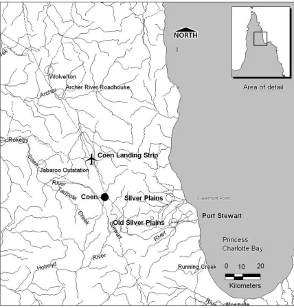
(28) Figure 3: Location of Coen and Port Stewart. 96.
(29) In the late 1960's there was an attempt by the government to close the settlement at Lockhart River. Some of the people were at that time relocated to Umagico. Instead of closing Lockhart, the settlement was eventually moved from ‘old site’ to the present location closer to the Iron Range airstrip. In 1964 there were 64 Lockhart River people living at Umagico (Long 1970:175). As Lockhart River continued as a community at the new site many of the people in Umagico have made their way back home in recent years.. 5.7 New Mapoon- Punja People There were three attempts by the Queensland Government to relocate Aboriginal communities to the new reserve. Firstly, some of the people from Mapoon were shipped to Red Island Point, settled temporarily at Bamaga and then taken to the present site of New Mapoon (previously known as Charcoal Burner (See Figure 2). Others from Mapoon had already been relocated to Weipa. This notorious incident has been widely reported (see Roberts et al 1975-6). Through this action the Queensland Government hoped to facilitate bauxite mining in the Mapoon area. Mapoon men who were at that time working for the prospecting company ‘Enterprise’ report that they were not told that their families had been moved but returned to find them gone and the village burnt (Jimmy Bond Snr 1990/1).. The Community at New Mapoon is comprised of older people who dream of their homelands, Mapoon the land of milk and honey, and younger people who have lived their whole lives in the cosmopolitan world of the tip! The young as a rule have no desire to move back ‘home’ and so there is tension in some families between some who would like to return to their land and the young who want to stay at New Mapoon. Even the young, however, see themselves as having a communal identity related to their homelands and hence the popular name for themselves “Punja People” and the name of the local football team Tongandji 97.
(30) (Tjungantji) Brothers. Punja is the Mapoon word for the waterlily seed that is a popular traditional food from the Old Mapoon swamps and Tjungantji is the local name for Cullen Point near the Old Mapoon Mission site.. In 1990 I took a group of people back to Mapoon in my role as a lecturer in the Ranger Training Program for the Cairns TAFE College. For some of the old people it was the first time they had returned to their homelands and it was therefore a very emotional experience. We have always provided for our people. Fresh springs line the beaches and the swamps are full of rindi, geese and punja. They did not need the white god that came but some gods are arrogant and he came anyway. We listened to the men who came carrying his cross, they claimed they did not want to change the culture of the people, but they didn’t like the old men having many wives. They did not want the people to talk to the spirits or use the language of the land. Today the language is gone! The people begin to return but how will they know us? The old ones are gone and they have none to teach them. We watched the truck as it stopped under the almond tree. The ruin of the mission house is nearby. Some say it is haunted, well it is ours again. What do they want these people? On weekends some of the young come out from Weipa, they break all the taboos and they hunt and drink and then go again! But wait there are old ones, perhaps they will know us. The old ones yarn of days gone by. They tell of the evil time when people were torn from the land, when spirits were abandoned to wander the landscape alone. 5.7.1. Jimmy & Mabel Bond’s Story. This is an extract of a story I recorded at Old Mapoon in 1991 as we camped under the almond tree in front of the ruins of the mission house. Jimmy:Yeah there was a company here before Comalco, Canadian Enterprise that one. You caught a plane to Agnew, that’s where the main camp was. They had there camp there at Batavia first. They had some boys working for them before I joined and they all left. That Enterprise the Miller mob bin work there. Where this lot (Canadian) bin work first, up at Agnew. You know when they walk away dey growl first and den bin 98.
(31) walk away. I do not know (what they bin growl about) might be something bout the company, might be men never liked the way they were treated. Then when they picked me and one old bloke Freddy’s grandad (Freddy Toby), Harry Toboy and William Parry. Them two companies (Canadian and Enterprise) pulled out and left Comalco. I was working at Bramwell Station and I came down here and I joined with Canadian. I think it was in the 60’s. (It must have bin early 60’s yufla bin go from here in 63). Mabel: Yeah. It bin during that time that Jimmy bin start to work...when they come back nobody was here. We bin stay at the back of the place with my sister. Jimmy: Yeah. I was working at < > then at that time and when I go home I see all the people bin evacuated. I didn’t know till we got back. Some bin shifted to Bamaga and some to Weipa. When I got back here, nobody was here. I didn’t know where to find my family. All the houses everything was gone. (Tape 1990/1). It is perhaps one of the cruellest ironies that men from Old Mapoon were employed to assist the geologists find the rock samples that would ultimately see the destruction of their village. It is also worth noting the callousness of the government of the time in that they failed to get word to people such as Jimmy Bond regarding events back home and the whereabouts and safety of his family.. 5.8. Neighbours to the South The nearest neighbours to these five communities are the people of Old Mapoon, Lockhart and then Weipa and Aurukun (see Figure 1). The community of Injinoo are related through marriage, trade and friendships with the first three of these communities but are not traditionally affiliated with Aurukun although they have established connections since the first Cape York Land Summit (see Plate 9) and the formation of the Cape York Land Council. Old Mapoon, Weipa and Aurukun are located. 99.
(32) on the west coast of the Cape while Lockhart is on the east.. 5.8.1 Old Mapoon Mapoon is located on the west coast of Cape York Peninsula at Port Musgrave and was established as a mission station in 1891 (see Figure 4). The Mission days at Old Mapoon are discussed at length in Chapter 7. As noted in section 5.7, the people of Mapoon were forcibly removed and relocated to New Mapoon in the NPA in 1963. Since that time however a growing number of Mapoon families have resettled in their homelands. The focus of the new community there is Red Beach although some families still camp along the beach where the old mission was located.. 5.8.2 Napranum or Weipa South Weipa, on the western side of Cape York Peninsula (See Figure 5), is currently divided into Weipa North and Weipa South. The former was set up as a ‘closed’ (i.e owned by the company) company town to service the Comalco operations in the area. It has now progressed to an ‘open town’ which means that it is no longer under the direct control of Comalco. Weipa South is the Aboriginal community and is located at the site of the former mission. It is more commonly known as Napranum since the hand back of management through Deed of Grant in Trust in the 1980’s. It is located approximately 14 km to the south of Weipa North.. The modern community of Napranum is in some ways quite different from other northern Cape York communities. The complexity of the community is partly due to the relationships between various local Aboriginal clan groups that are present there, the long-standing period of missionary influence and interactions with Comalco and its resources. 100.
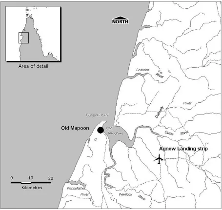
(33) Figure 4: Location of Old Mapoon. 101.
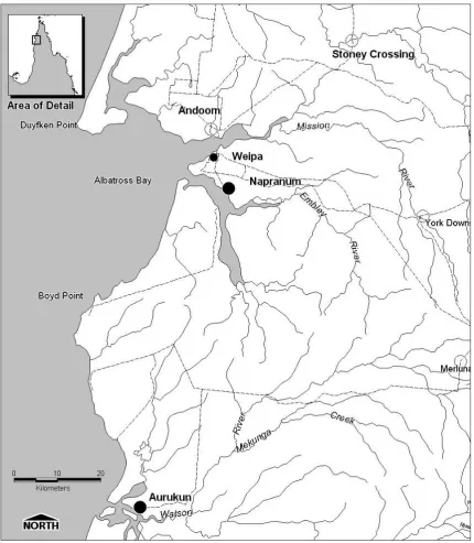
(34) Figure 5: Locational Map Weipa and Aurukun. 102.
(35) Despite Meston’s advice (1895) that the Aboriginal people of western Cape York were doing quite well on their own and should basically be left alone (see Chapter 7), the Queensland government supported the Presbyterian Church’s drive to establish a chain of missions in the area. The Mission at Weipa was first established at a place known as ‘20 mile’ but later moved to Jessica Point (in 1932), a more accessible spot for sea access and less affected by malarial mosquitos. The missionaries were still operational in the 1950’s when serious exploration for bauxite was commenced in the area. However the post war period was a difficult one for the missions. Mission enterprises had never regained their pre-World War II productivity due to the changes that the war had brought to the regional economy.. In late 1957 the Queensland Government granted extensive mining leases to the newly formed Comalco under the Commonwealth Aluminium Corporation Pty Ltd Agreement Act of 1957. Aboriginal people were not a party to the negotiations relating to the mining agreements or granting of leases nor did they have any power over the future of the missions. The church represented their interests along with the Queensland government (the latter having a significant conflict of interest in the matter). The plan was to move people from Mapoon Mission to the Weipa mission and then relocate the Weipa mission to a more ‘convenient ‘ location. When many of the people of Mapoon refused to relocate to Weipa they were forcibly removed to Bamaga (see 5.2). Finally the government, Comalco and the Church renegotiated a lease, which included the immediate surrounds of the Mission area although considerably smaller than the previous area (That is, 354,828ha reduced to 124 ha). In 1966 the government finally took over the administration of the community from the Church.. The Napranum community today is a mix of traditional owners from the immediate local area, Mapoon people who relocated at the time of the closure of Mapoon and those who have since moved there to 103.
(36) join family, and Torres Strait Islander people who where initially attracted to the mine at Weipa North for employment, who have married into families at Napranum. Due to its unique situation Weipa has some complex opportunities and problems. There is no doubt that the proximity to, and relationship with Comalco provides employment and training opportunities that the community would not otherwise have had. The proximity to a Comalco town also means that people have access to fresh food and Western goods at reasonable supermarket prices and people from further north or Lockhart to the east envy this. Similarly there is relatively easy access to buy greater range of alcohol at much cheaper prices than other communities. While people have the advantage of a range of education and vocational training opportunities, traditional owners must face the daily reality of large scale open cut mining in their country for which they receive no compensation and over which they have no control. The final injustice is that once the mining company has finished with the area and rehabilitated it, it does not, even then, revert to Aboriginal ownership. Due to the revocation of the original mission lease and special legislation proclaimed in relation to the mining interests, the area reverts to the Crown. This has been a particularly bitter pill for traditional owners who say that they were told by the Church and the mining company that the land would be returned to them ‘as good as before’ (Joyce Hall pers comm. 1990).. The links between the northern communities and Weipa are largely due to the presence of Mapoon people in both areas. Mapoon people had traditional marriage links with Seven River people, some of who had settled there while the rest went to Cowal Creek (Injinoo). In addition, since some people had moved to Weipa in the year preceding the forced closure of Old Mapoon, there is frequent movement between family members in New Mapoon and Weipa. Modern day Napranum has recent Islander immigrants many of whom are Kaurareg people with relations in Injinoo. The recent movement of Torres Strait Islander people (particularly Kaurareg) 104.
(37) has also increased the interconnections and movements between Injinoo and Weipa.. 5.8.3 Aurukun The community of Aurukun is situated on the west coast of Cape York Peninsula in the Gulf of Carpentaria (see Figure 5). The 1999 census records for Queensland records 866 people living in the shire of Aurukun. In 1996 it is noted that a total of 825 people resided there, 725 of who were Aboriginal Australians. Originally established as a Presbyterian Mission in 1904 the settlement of Aurukun reformed as the Shire of Aurukun in 1978 following the withdrawal of the missionaries and the transfer of management responsibility to the Queensland government and following resistance on the part of the people of Aurukun to being incorporated into the reserve system. The community was granted a 50 year lease over the shire lands under the administration of the shire clerk and an elected Aboriginal council.. This government structure meant that Aurukun was theoretically not subjected to the same level of direct control by the Queensland government as the other ‘reserve’ communities of Cape York Peninsula. However in practice this system did not achieve autonomy for the Aboriginal people of Aurukun as the criteria for selection of shire clerk ensured that the position was held by a nonindigenous person who was supported by predominantly ‘white’ council staff. The management role of the Aboriginal council members was a nominal one.. In recent years Aurukun community has suffered from the tensions created by a growing population of people from different clan groups who have been forced to live together. The affects of alcohol abuse have been exacerbated by the remoteness of the area, which has provided a niche for ‘grog runners’ who have been able to thwart community attempts to follow a ‘dry’ (i.e. alcohol free) community. The most serious cases of grog running have involved 105.
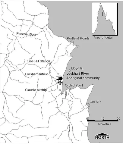
(38) non-indigenous people bringing in supplies of alcohol and selling them for enormous profits. In response to these and other community pressures some community elders have moved out of the village and back to their traditional lands taking their families with them (see also Martin 1981). The recent Wik decision handed down in November 2000 has recognised the Native Title rights of the Wik people and given an added impetus to the already strong outstation movement7 in Aurukun.. 5.8.4 Lockhart River Lockhart River Aboriginal Community is situated on the eastern seaboard of Cape York Peninsula at Lloyd Bay (see Figure 6). The community comprises a number of cultural groups including the Wuthathi from north of Olive River, the Kuuku Ya’u from Lloyd and Weymouth Bays, the Uuthalganu from the Lockhart River south to Friendly Point, the Umpila from Friendly Point to the Massey River and the Kaanju from the inland mountain country behind these. Over the years a number of Torres Strait Islander people have married into the community and have added to this linguistic and cultural diversity (for a more detailed account of the community and its culture see Chase 1980, 1994).. The Anglican Church established the Lockhart River Mission in 1924. Prior to this, Hugh Giblet a local sandalwood cutter who was located at Lloyd Bay appears to have provided a focal point for people to come together loosely as a community largely as a labour pool for the sandalwood trade. No doubt this was a symbiotic relationship with Aboriginal people providing an available if. 7. The Outstation movement is the name given to the voluntary movement of small groups of people out of the townships and back to their traditional lands. Usually to pursue a more traditional lifestyle away from the pressures of the growing townships and villages. 106.
(39) Figure 6: Location of Lockhart River Aboriginal Community. 107.
(40) somewhat flexible labour source and Giblet providing some protection from authorities and potential exploiters alike.. As at other missions in Cape York, dwindling post war productivity of mission enterprises and a refocus of evangelical attention to other countries such as China led to the closure of the missions. The. Queensland. government. took. over. the. control. and. administration of the communities. At Lockhart it was reported that a committee with Aboriginal representation was convened to consider the future of the settlement (Directors Reports 1962-3: 1820 cited in Long 1970: 175). It was intended that Lockhart River people be absorbed into the super reserve, the NPA. The lease over Laradeenya Pastoral holding was resumed from Stan Holland as an option for the relocation. The Department of Native Affairs favoured a move to Alau near Bamaga (Long 1970). The location had been renamed Umagico, the name deriving from Umagi an important place near ‘old site’ at Lockhart River. However in the end it was agreed that Lockhart village would be re located closer to Iron Range Airfield but within the homelands of Lockhart River people.. While the Lockhart River community is one of the most geographically isolated in the Cape it has fought a number of key battles over recent years over threats and incursions into their land. These include opposition to the expansion of National Parks, the illfated Lloyd Bay Resort proposal, silica sand mining proposals in the Whitesand country immediately to the north of the community and the proposed space sport near Olive River. There are strong links between Lockhart River and Injinoo people as witnessed by the fact that some Wuthathi people live in both places. There are also strong long-standing links between Lockhart River people and their neighbours on the Western side of the Cape. It was something of a shock to the defence forces stationed at Iron Range during World War II to find that people actually walked between these apparently isolated communities trading information and goods. An 108.
(41) investigation into security issues at Iron Range in May 1943 noted that …Seven Aboriginals and halfcastes, some of whom had been previously employed by CCC recently returned from Mapoon Mission on the Gulf side of the Peninsular [sic] and were reemployed. It’s understood that they freely discussed Australian and US troop concentrations in the Wyper River area and there does not seem to be any form of restriction on the periodic movement of this type of itinerants (cited in Marks nd: 30).. 5.9. Conclusion. The communities in northern Cape York today have each developed unique identities based on a synthesis of pre-contact and historic experiences and beliefs. There is increasing contact between communities as they develop both economically and politically in the post reserve era. There is also increased contact between these communities and the members of the broader Australian. public.. Whereas. in. the. past. most. black/white. relationships in northern Cape York have been set within the paternalistic framework of first the missions and then the government reserves now increasingly relationships are being forged on a more diverse basis. Examples of this include black employer/white employee or contractor, white tourist/black host, and even Indigenous religious leader/white congregation.. While there is increasing emphasis on new relationships there is also a strong emphasis on cultural continuity. Many communities are seeking way to develop and support community identity through times of change by promoting their history and taking a more active role in the formal education of their children (e.g the community school at Injinoo). Despite strong traditional bonds and in some case new political bonds there is still in some cases strong intercommunity rivalry and competition for resources. The following Chapters expand on some of the historical influences that have contributed to the character of the Cape York communities, as they exist today.. 109.
(42) Chapter 6 _______________________________________ PASTAIM 6.1 Falls the Shadow8: The Establishment of Somerset The strangers come more frequently nowadays. Once before they had come and sought to take the land. They caused the people much pain and the spirits and we grew restless, swelling rapidly in number as the marakai plundered and diminishing as traditions were trampled. Jardine! Ah yes, that was the name! We scattered his cattle and stole his tools but in the end we gave him his dream, to live here forever and to be held in awe. He is still here under the strange monument. Those who brought the ‘light’ made the people erect them to imprison the spirits of the dead, to prevent them living on, as they should. But Jardine has outsmarted the Light. Sometimes he emerges as a large taipan9, during the day he shelters from the sun under his concrete prison. With the coming of the first marakai things changed but some things endure. We have reclaimed the forest where once his cattle roamed and where the soldiers lived. Inside the shade of the scrub we lie in wait for the unwary. Trespass here and we will turn your head until you wander aimlessly and all your pretty little things will be forfeit. For all that its flare in world history was tentative and short-lived, quite a surprising amount has been written about Somerset and the Jardine family who pioneered its settlement. As with many pioneer stories, most of the accounts are thick with romantic bias. In the title of his work ‘A Barren Promontory: The Failure of the Colonial Vision at Somerset, Cape York Peninsula 1864-1877’, Stevens (1980) captures part of this. Isolated, failed attempts at colonial settlement capture public interest because of the poignant suggestion of failed dreams, struggles and hardship. Stevens discusses the reasons behind the rise and fall of the colonial dream 8. From T.S Eliot “The Hollow Men” ‘Between the conception. And the creation Between the emotion And the response Falls the shadow’ 9 On one of my visits to Jardine's grave I was surprised by a large snake that had made its home under the headstone. I exclaimed about it (somewhat shakily as I had come upon it quite suddenly). Mrs Sagigi just said "that. 110.
(43) at Somerset. The generally accepted history of Somerset has been summarised by Sharp (1992) and is contained in part in works like Prideaux (1988). These studies however are not based on systematic research into the history of the settlement and like most publicly accessible information they rely heavily on secondary sources and a large amount of hearsay, which has entered the public domain and taken on the dimensions of folklore.. In 1860, the HMS Sapphire was shipwrecked and the survivors had to sail 900 miles to Port Curtis, the nearest European Settlement. This was the catalyst that spurred the Governor, Sir George Ferguson Bowen, to suggest establishing a station in the Torres Strait as a joint venture between the Imperial and Colonial governments (CO 234/2: 1860).. As a result, in 1864 the Imperial and Queensland governments determined to establish a harbour of refuge at Port Albany, Cape York. Governor Bowen selected the site himself after a reconnaissance voyage on the HMS ‘Pioneer’ which left Brisbane on the 27th August 1862. (Austin 1949:218; see also QPP Despatch #24 Richards 1872 QSA Col/A216). ‘On April 4th 1865, the first sale of Crown Land for the new settlement of Somerset took place in Brisbane’ (Kennedy 1902:9). Seventy lots of land were offered for sale. Kennedy reports that they were bought for £20 per acre. In all 109 town allotments were sold at auction for a total of £2093.3.0. The settlement was to be called Somerset and its primary purpose was to provide support to colonial shipping as a refuge to shipwrecked sailors and a re-fuelling and re-victualling port. A secondary aim was to secure the northern coast for the Imperial Government. Australia was a large continent with an unguarded coastline that was largely unsettled by the colonists. Therefore the government was ever conscious of the risk of rival empires annexing parts of the country. But the enthusiasts who purchased one em now-Jardine!". No one disputed this they all nodded solemnly. Somerset is like that, a place where things are. 111.
(44) the land ‘site unseen’ at auction were obviously hoping for more than this, and no doubt they anticipated a thriving trading port to develop, consistent with the Government’s sales hype that Somerset would become a ‘second Singapore’. In 1865 Somerset was declared a ’free port’ in the hope that this would act as a catalyst to trade development (Farnfield 1975: 70).. Somerset was established in 1864 and had a brief lifespan as a Government settlement until 1877 when it was abandoned in favour of Thursday Island. It appears that the selection of the site was made hastily and based on emotive first impressions rather than on sound knowledge of the landscape and environmental conditions. Once the reefs and waters of the Torres Strait were more intensively mapped, it became clear that preferred shipping channels would bypass the new settlement, as the waters of Albany Passage were difficult to navigate. Stevens (1980) cites hostility of the local Aborigines as a major factor in the decision to move the settlement. However, this appears unlikely as the traditional owners of Thursday Island, the Kaurareg, had been responsible for as many (if not more) hostile attacks on ships and Europeans as their mainland neighbours. The value of Albany Passage as a shipping route had lessened as its troublesome reefs were better mapped, and a new route which passed closer to Thursday Island had been mapped and was being used as the preferred shipping channel.. It is hard to believe that this settlement, which lasted only 13 years, could have had such a major effect on the future of the area and on the lives and livelihood of the majority population group, the Aboriginal people of northern Cape York. While the Jardine family remained in residence at Somerset until 1919, the site itself does not bear great testimony to colonial settlement. All that remains on the surface are the graves, some tumbledown stone garden walls, scattered broken glass, a well and a few isolated and dying coconut not always as they seem.. 112.
(45) trees (see site description and site plans in Chapter 11). What nature did not claim, the Queensland government bulldozed in 1967.. 6.2. The Jardines Arrive. We had seen their kind before. The people called them “marakai” and it is true that they haunted the landscape. Arriving from the sea, pale and wraith- like. At first we did not take notice, we satisfied ourselves by playing with their strange huge canoes getting them lost and entangling them in the reefs. Many times they strayed into areas that were forbidden and sometimes we revenged ourselves on them by sinking their vessels. We thought that, like the people, they would learn to live by the rules but they did not. They were peculiar and headstrong creatures who took from the sea and the land without ever paying their dues to the spirits or us. Then came the old man. He came and put up a flag; many supplies were unloaded from the large clumsy canoes, which managed to stay afloat by some strange unknown magic. Later we heard the cries of the land and the people as the brothers slowly made their way north from the unknown void to the south. Scattered behind them, the people who had crossed their path lay dead or dying.. The main family characters in the history of the area are John Jardine Snr who was the first Police Magistrate, and his sons Alex, John and Frank. Any account of the Jardine family and their influence in the area is bound to raise more questions than it answers. It is difficult to get a clear view of each of the characters and the role that they played in the history of the area. This is due partly to the fact that Frank Jardine, who had the longest and most powerful influence on the area, overshadows the other family members. In most local accounts he is simply referred to as 'Jardine' and even amateur histories (particularly those associated with the tourism industry) collapse all activities by the Jardine family into stories about Frank.. 113.
(46) John Jardine Snr (1807-1874) was appointed Commissioner of Crown Lands, North Cook and Police Magistrate of Somerset in February 1844. He arrived at Somerset accompanied by his youngest son John Robert (1847-1911) aboard the 'Eagle' in June 1864, to take up his post as Police Magistrate. Prior to accepting the post he was Commissioner of Crown Lands and Police Magistrate of Rockhampton and before that he held the equivalent position in Dubbo, NSW.. Two more of John Jardine’s sons became involved in the establishment of the new settlement. Frank Lascelles Jardine (1841-1919) his eldest son and Alexander William Jardine (18431920) led an overland expedition to drive cattle and horses to the new settlement. Alexander Jardine left Rockhampton on the 14th of May 1864 with a party of 9 other people and 31 horses. He met up with his brother in Bowen where they purchased more horses. The brothers again split up with Frank remaining in Bowen to purchase cattle and Alexander proceeding to Carpentaria Downs the most northerly cattle station in Queensland at that time. On the 11th October the Jardine expedition finally departed Carpentaria Downs into the unknown expanse of Cape York Peninsula. The party comprised Frank Lascelles Jardine, Alexander Jardine, Archibald J. Richardson (Government Surveyor), C Scrutton, R. N Binney, A. Cowderoy, Eulah (later killed in an uprising at Vallack Point in 1868), Peter Sambo and Barney (the latter 3 eventually executed by Frank Jardine in 1868). The latter four Aboriginal men were exnative troopers from the Rockhampton and Wide Bay areas. While it was not uncommon to hire Aboriginal guides, no one ever seemed to question how Aboriginal people from areas far removed, without kinship and language, could be expected to guide people or communicate with or determine the intentions of the Aboriginal people that they came across on the journey. The expedition was taking with them 41 horses, 1 mule and 250 head of cattle (Bryerley 1867:7). There were of course no roads and the interior of Cape York had never been mapped. Only the river 114.
Figure
+2
Related documents
This systematic search was developed in response to the Queensland Government Centre for Social Science Innovation (QCSSI) research priority area of Aboriginal and Torres
AAA Conference 2001 Aboriginal and Torres Strait Islander Studies Unit The University of Queensland BRISBANE QLD 4072 AUSTRALIA.. URL: www.ansoc.uq.edu.au/aaa
• Northern Territory: all departments but see especially Department of Community Services • Queensland: Department of Aboriginal and Torres Strait Islander and Multicultural Affairs.
Objective: To estimate the prevalence of mental disorder in a representative sample of Aboriginal and Torres Strait Islander people in Queensland prisons.. Design, setting
The Health and Welfare of Australia’s Aboriginal and Torres Strait Islander Peoples, Canberra: Australian Government Publishing Service; Australian House of Representatives
66 Queensland Treasury, 2014 Service Delivery Statements Department of Aboriginal and Torres Strait Islander and Multicultural Affairs available at
• Representatives from Aboriginal and Torres Strait Islander communities – Greater Sydney Family Pathways Network – Aboriginal Family Law Pathways and the Closing the Gap
Agency briefings (Roadshow) Met with representatives from the Department of Employment, Economic Development and Innovation (including Aboriginal and Torres Strait Islander
