This is the
Accepted Version
of a paper published in the
journal: Marine Biodiversity
Beaman, Robin J., Bridge, Tom C.L., Lüter, Carsten, Reitner, Joachim, and
Wörheide, Gert (2016) Spatial patterns in the distribution of benthic
assemblages across a large depth gradient in the Coral Sea, Australia. Marine
Biodiversity, 46 (4). pp. 795-808.
http://dx.doi.org/10.1007/s12526-015-0434-5
Spatial patterns in the distribution of benthic assemblages across a large depth gradient in the 1
Coral Sea, Australia 2
3
1Robin J. Beaman*
4
2,3Tom C. L. Bridge
5
4Carsten Lüter
6
5Joachim Reitner
7
6Gert Wörheide*
8
9
1College of Science, Technology and Engineering, James Cook University, Cairns, Queensland, Australia
10
2ARC Centre of Excellence for Coral Reef Studies, James Cook University, Townsville, Queensland,
11
Australia
12
3Australian Institute of Marine Science, PMB No. 3, Townsville, MC, Queensland, Australia
13
4Museum für Naturkunde, Leibniz-Institut für Evolutions- und Biodiversitätsforschung, Berlin, Germany
14
5Faculty of Geosciences and Geography, University of Göttingen, Göttingen, Germany
15
6Department für Geo- und Umweltwissenschaften & GeoBio-Center, Ludwig-Maximilians-Universität
16
München, München, Germany
17
18
*Corresponding Authors:
19
Robin J. Beaman,
20
Ph. +61 7 4232 1693
21
Fax. +61 7 4232 1284.
22
E-mail. [email protected]
23
24
Gert Wörheide,
25
Ph. +49 89 2180 6718
26
E-mail. [email protected]
27
28
29
30
Manuscript2 clean Click here to view linked References
Acknowledgements 31
We thank the German Research Foundation (DFG) for the funding (projects Wo896/7 and Lu839/3, to
32
GW and CL respectively) and Marum (www.marum.de) for the ROV equipment supplied for the Deep
33
Down Under Expedition (www.deepdownunder.de). We also thank the captain, crew and scientific party
34
aboard the MV PMG Pride who undertook the sampling during the 2009 voyage. We thank Nicolas
35
Nowald for assistance with the ROV raw data and Andrew Gray-Spence for the Python program coding
36
used for the video data. Taxonomic help is gratefully acknowledged from Marc Eleaume, Richard
37
Fitzpatrick, Merrick Ekins, Phil Alderslade, Stephen Cairns, Justin Marshall, Vanessa Messmer and Rudi
38
Kuiter. We thank the two anonymous reviewers for helping to greatly improve the manuscript.
39
40
Abstract 41
The Queensland Plateau in the Coral Sea off north-eastern Australia supports numerous submerged and
42
emergent reefs. Osprey Reef is an emergent reef at the northern tip of the plateau ~1500 m in elevation.
43
Over such a large depth gradient, a wide range of abiotic factors (e.g. light, temperature, substratum etc.)
44
are likely to influence benthic zonation. Despite the importance of understanding the biodiversity of
45
Australia’s Coral Sea, there is a lack of biological information on deep-water habitats below diving
46
depths. Here we used a deep-water ROV transect to capture video, still photos and live samples over a
47
depth range spanning 92 to 787 m at North Horn on Osprey Reef. Video analysis, combined with
48
bathymetry data, was used to identify the zones of geomorphology and the benthic assemblages along the
49
depth gradient. There were marked changes in the geomorphology and the substrate along this depth
50
gradient which likely influence the associated benthos. Cluster analysis indicated five benthic assemblage
51
groups, which showed clear zonation patterns and were generally predictable based on the depth and
52
sedimentary environment. These results are the first quantitative observations to such depths and confirm
53
that the waters of the Coral Sea support diverse benthic assemblages, ranging from shallow-water coral
54
reefs to mesophotic coral ecosystems, to deep-water azooxanthellate corals and sponge gardens. The
55
knowledge provided by our study can inform management plans for the Coral Sea Commonwealth
56
Marine Reserve that incorporate the deeper reef habitats and help to minimise future damage to these
57
marine ecosystems.
58
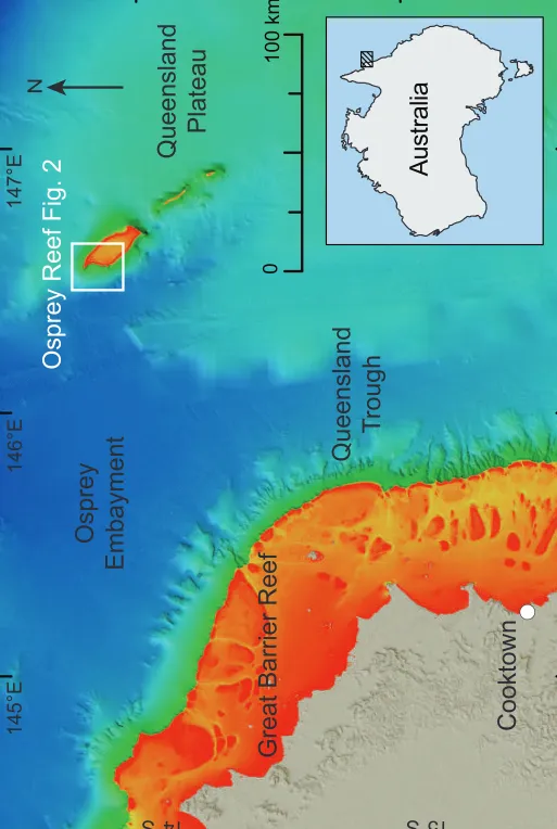
Keywords 59
Osprey Reef; benthic; zonation; geomorphology; mesophotic; coldwater coral; sponges
60 1
Introduction 61
The Coral Sea region off north-eastern Australia contains numerous pinnacles and modern reef complexes
62
that have formed on rifted continental blocks within the Queensland Plateau, the largest marginal plateau
63
on the Australian continental margin (Davies et al. 1989). Approximately the same size as the Bahama
64
Platform, this large (~165,000 km2) submerged carbonate platform formed when the Coral Sea Basin
65
opened in the Palaeocene about 60 Ma splitting off fragments of continental lithosphere (Mutter and
66
Karner 1980; Symonds et al. 1983). Subsidence and drowning commencing in the Middle to Late Eocene
67
(42-37.5 Ma) led to its present median depth of about ~1100 m. The Queensland Plateau now supports
68
~30 emergent and submerged reefs growing on the corners of these basement high points, some with
69
elevations over 1000 m above the surrounding plateau and basins. The emergent reefs include large banks
70
(over 100 km long) and smaller reefs and pinnacles (several km to 100 m wide), with living reef systems
71
occupying almost 15 percent of the surface of the Queensland Plateau.
72
73
Coral reef development on the Queensland Plateau commenced growing when the Australian plate moved
74
into the tropics in the Early Miocene (22 Ma; Davies et al. 1988). In contrast, the major reef growth on
75
the neighbouring Great Barrier Reef (~100 km to the west) commenced much later, between 452 and 365
76
ka (Webster and Davies 2003) and has been continually disrupted by the cyclic falling and rising of
77
eustatic sea-levels. Indeed, reef growth on the Queensland Plateau continued even during the Late
78
Miocene and Pleistocene lowstand sea-levels (120-200 m below present) when only the upper parts of the
79
coral reefs on the plateau were most likely exposed (Davies et al. 1989). The emergent reefs of the
80
Queensland Plateau were likely to be important refuges for coral reef taxa during these lower sea-levels,
81
and may also have provided the Great Barrier Reef with a source of propagules after catastrophic events,
82
a hypothesis recently supported by genetic data (Wörheide et al. 2002; van Oppen et al. 2011). Hence
83
these reefs, some of the largest in the world, should be afforded greater research attention.
84
85
In 2012, the Australian Government proclaimed nearly 1 million square kilometres in the Coral Sea as a
86
marine reserve. The Coral Sea Commonwealth Marine Reserve extends over the Queensland Plateau, and
87
includes the large Diamond Islets, Diane Bank, Lihou, Flinders, Coringa-Herald, Holmes, Bougainville,
88
Shark and Osprey reefs. Australia’s marine reserves, including the Coral Sea Commonwealth Marine
89
Reserve, are currently under review and require information on key ecological features and their
90 1
conservation values. However, the remote location of the Coral Sea has resulted in a paucity of scientific
91
data on the deeper environments of this region (Ceccarelli et al. 2013). The majority of research that has
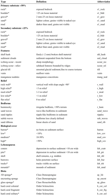
92
been conducted on benthic ecosystems in Australia’s Coral Sea has focussed on the shallow-water coral
93
reefs, generally in water depths of less than 20 m (Ceccarelli et al. 2013). More recent observations of the
94
mesophotic (30-150 m), disphotic (some light but not enough to sustain photosynthesis ~150 to 250 m)
95
and aphotic (no light and deeper than ~250 m) zones in the Coral Sea have indicated that these waters
96
also support diverse benthic communities (Bongaerts et al. 2011; Wörheide et al. 2011; Wörheide et al.
97
2012). These include a ‘relict' fauna of brachiopods (Lüter et al. 2003), coralline sponges (Wörheide
98
2008; Karlińska-Batres and Wörheide 2013) and Hexactinellida (Dohrmann et al. 2011) discovered at
99
Osprey Reef.
100
101
Marine benthic communities commonly exhibit clear zonation along depth gradients from surface waters
102
to the deep-sea, attributed to various factors including substratum type, temperature, pressure, water
103
chemistry, food and energy availability (Grassle et al. 1979; Cartes and Carrasson 2004; Carney 2005).
104
The emergent reefs of the Queensland Plateau therefore provide a habitat for benthic communities
105
spanning depths ranging from the sea surface to greater than 1000 m. Their steep flanks are likely to
106
support a diverse range of benthic communities, including shallow-water coral reefs, mesophotic coral
107
ecosystems (MCEs), and deep-water azooxanthellate corals and sponge gardens. Therefore, the flanks of
108
a Coral Sea reef could be expected to exhibit zonation in benthic assemblages when descending from the
109
shallow sunlit surface waters, through the twilight mesopelagic and disphotic zones, then into the deeper
110
and cooler aphotic waters. However, no studies have quantitatively examined the composition and
111
zonation of benthic communities on Australia’s Coral Sea reefs beyond diving depths.
112
113
In 2009, the Deep Down Under expedition (www.deepdownunder.de) to Australia's Coral Sea area
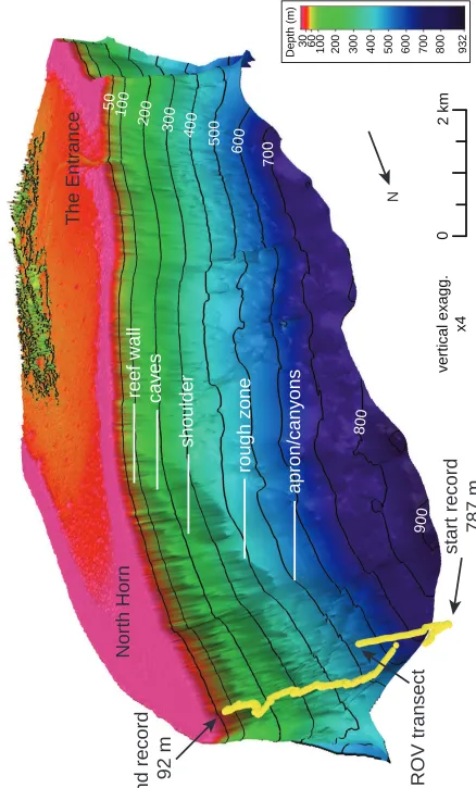
114
targeted Osprey Reef, which is situated at the northern tip of the Queensland Plateau (Fig. 1). The reef is
115
separated by about 125 km from the north-eastern Australia margin by the Queensland Trough and is
116
surrounded by clear, oceanic waters unaffected by continental sedimentation. Osprey Reef is steep-sided,
117
rising ~1500 m above the surrounding seafloor of the Queensland Plateau to the south-east and about
118
2500 m above the deeper Queensland Trough and Osprey Embayment to the north-west of the reef. The
119
shallow reef platform is 28 km long by 10 km wide, with a lagoon about 40 m deep enclosed by a
continuous rim rising to the sea surface. North-west Osprey Reef forms a distinct point known as ‘North
121
Horn’, which was chosen as the location of the present remotely operated underwater vehicle (ROV)
122
study (Fig. 2).
123
124
The surface water circulation in this region is dominated by the East Australian Current (EAC) which
125
forms on the Queensland Plateau from the South Equatorial Current (SEC; Church 1987). Around latitude
126
15° S, the EAC flows southward following the Great Barrier Reef shelf. Part of the SEC forms a
127
clockwise gyre called the Coral Sea Counter Current or Hiri Gyre which flows northward past Osprey
128
Reef and into the Gulf of Papua (Wolanski et al. 1995). Below these tropical surface waters are cooler
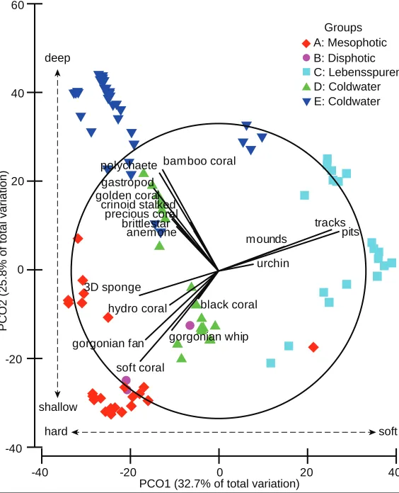
129
water mass properties indicative of Subantarctic Mode Water at a depth of about 600 m (SAMW;
130
Solokov and Rintoul 2000; Hartin et al. 2011) and of Antarctic Intermediate Water (AAIW; Solokov and
131
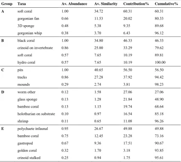
Rintoul 2000; Hartin et al. 2011) below 700 to 1000 m. SAMW and AAIW enter the Queensland Trough
132
from the south and flow northwards towards the Coral Sea Basin (Solokov and Rintoul 2000). The area is
133
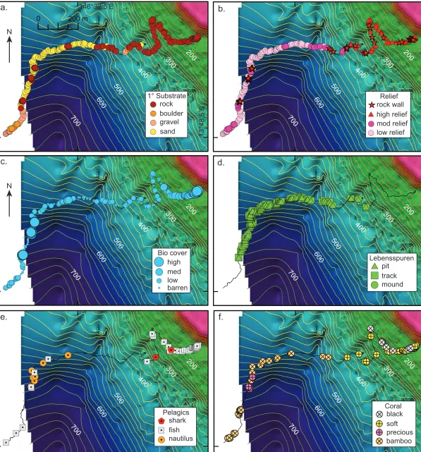
also impacted by tropical cyclones with recent cyclones passing over Osprey Reef in May 2013 and
134
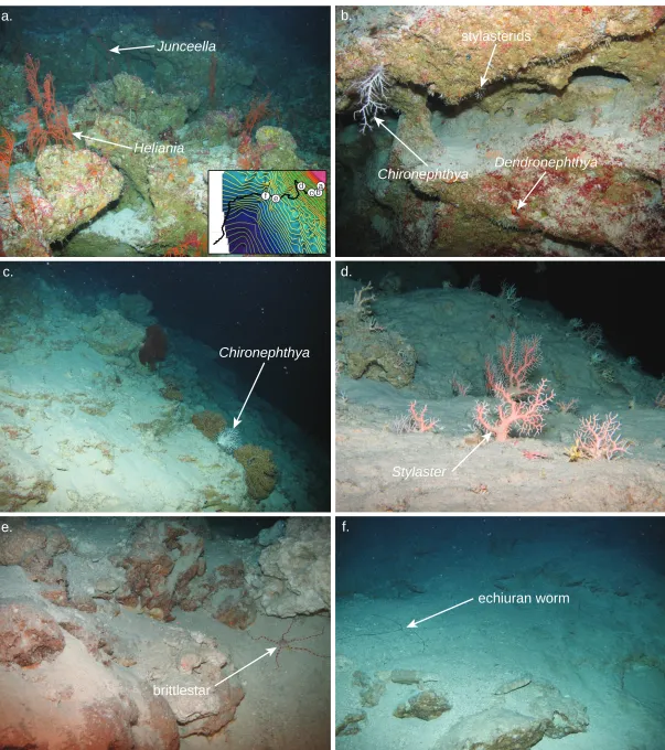
March 2015.
135
136
In this study, we have used a high-resolution digital elevation model (DEM), and the video and still
137
imagery collected by a deep-water Cherokee ROV, to identify the spatial patterns in geomorphology and
138
benthic assemblages found along a depth gradient spanning 787 m at Osprey Reef in the Coral Sea. We
139
show that Osprey Reef supports diverse benthic assemblages, and identify defined geomorphic zones
140
characterised by distinct benthic assemblage groups that were generally predictable based on the depth
141
and sedimentary environment.
142
143
Methods 144
Bathymetry data 145
Bathymetry data around North Horn were collected between 2006-2008 by the MV Undersea Explorer
146
using a Raymarine DSM300 singlebeam echosounder (dual 50/200 kHz) rated to about 1000 m depth.
147
Raw bathymetry and position data were imported to Caris HIPS/SIPS post-processing software, then
148
predicted tides and a modelled sound velocity were applied and edited to remove noise. The final xyz data
149
were imported to ESRI ArcGIS and combined with Royal Australian Navy airborne lidar bathymetry data
from the reef flat and lagoon at Osprey Reef. The ArcGIS application Topogrid was used to generate a
151
0.0001-arcdegree (~10 m) resolution ESRI grid for north-western Osprey Reef. The ESRI grid data were
152
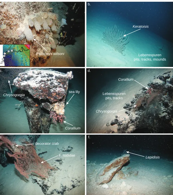
also imported to QPS Fledermaus software for 3D visualisation.
153
154
ROV survey 155
ROV data were collected using the 34 m utility vessel MV PMG Pride during the Deep Down Under
156
expedition to the Queensland Plateau (www.deepdownunder.de). Imagery and specimens from benthic
157
ecosystems were collected using the Marum (www.marum.de) Cherokee ROV depth rated to 1000 m
158
with a weight of 450 kg and dimensions of 1.4 x 0.88 x 0.8 m. Propulsion uses 4 axial thrusters with a
159
vertical thrust of 45 kgf or a velocity of ~0.3 ms-1. A surface-controlled manipulator arm can collect
160
samples up to 7 kg. Optical devices include a Tritech Typhoon colour zoom videocamera (720 x 576
161
pixels), Kongsberg OE14 digital still camera (5 megapixel), a three red laser array (30 x 23 cm) and a 230
162
W spotlight. An IXSEA GAPS system provided USBL, INS and GPS absolute positioning of the ROV,
163
as well as the surface position of the vessel.
164
165
The ROV dive at North Horn was conducted from 11-12 December 2009 UTC over a period of 5 h 42
166
min, from the depths 787 to 92 m. Video data were streamed to the surface for recording as mpeg files on
167
MiniDV VCRs, together with the timestamp, position and depth overlays. This resulted in six mpeg files
168
each about one hour long. The still images were recorded internally on the ROV, timestamped and
169
downloaded to CD on recovery of the ROV. The ROV position and depth sensor data and timestamps
170
were recorded into CSV files at 5 s interval.
171
172
Data analysis 173
The ROV navigation data for Longitude, Latitude, Depth, Year, Month, Day, Hour, Min, Sec were
174
recorded continuously to an Excel spreadsheet for the video data. These records were parsed to show only
175
whole-minute positions, resulting in the availability of 343 x one-min records. A Cherry SPOS keyboard
176
(Model G86-63400) provided up to 144 keys programmed using a classification scheme of physical and
177
biological parameters to append a Characterization sample to the spreadsheet (Table 1). This
178
characterization method is similar to the underwater video analysis conducted by Anderson et al. (2007)
179
and Post et al. (2011) for analysis of benthic survey data collected in other regions. The classification
scheme in Table 1 is for generic use in the deep-sea with the main headings of: Primary substrate (>50%),
181
Secondary substrate (>25%), Features, Relief, Bedforms, Biological cover, Lebensspuren, Biota and
182
Additional. Lebensspuren refers to the ‘life traces’ from bioturbating animals (Przeslawski et al. 2012).
183
184
The video files were viewed for a 15 second period at each whole minute, then classified using the
185
parameters in Table 1. For every one-min sample, both the Primary and Secondary substrate were
186
recorded into an Excel spreadsheet, in addition to the Relief type, Biological cover and any biota
187
observed. Biological cover was a qualitative measure: barren has no biota observed; low 10%; medium
188
10-50%; and high >50%. The keyboard provided a relatively quick method of recording the classification
189
by adding an abbreviation code into the Characterization cell for each one-min sample. The
higher-190
resolution still images provided assistance to classify the physical environment and biota where the video
191
data were unclear. The physical specimens collected by the ROV and now archived at the Queensland
192
Museum in Brisbane, Australia, provided additional confirmation of the taxon classifications.
193
194
Video data were converted to a presence/absence matrix using a Python program script, with each cell
195
assigned either 1 or 0 under the column headings representing every classification type shown in Table 1.
196
This presence/absence matrix was imported into a point shapefile for visualisation in ArcMap 10.1 to
197
show the positions and observed parameters of each one-min sample (Excel spreadsheet of the data
198
matrix is given in Online Resource 1).
199
200
Cluster analysis 201
Patterns in the distribution of the benthic biota data were examined using multivariate techniques in
202
Primer v6 (Clarke and Gorley 2006). The cluster analysis data excluded the demersal fish, pelagic shark
203
and the biological cover variables. The Primary substrate and Relief types were added as factors for each
204
1-min sample in the Primer worksheet. The presence-absence data were converted to a Bray-Curtis
205
similarity resemblance matrix to quantify the similarity among samples. The resemblance matrix was
206
analysed using group-averaged cluster analysis and the Bray-Curtis similarity displayed as a Principal
207
Coordinates (PCO) plot, with symbols visualised as five groups using Bray-Curtis similarity clustered at
208
45% similarity. SIMPER analysis was conducted to identify the main contributing taxa for each benthic
209
assemblage group, shown in Table 2. Additionally, an abiotic matrix was created using the Primary
substrate and Relief records, together with depths binned as arbitrarily coded depth ranges of 150 m (e.g.
211
<150, 150-300, 300-450, 450-600, 600-750 and >750 m). With a total ROV sample range of 695 m, from
212
the deepest record at 787 m to end of the dive in 92 m, the 150 m bins were considered an optimal bin
213
size for abiotic analysis. The variables (Substrate, Relief and Depth) were initially ranked, and then biota
214
and abiotic matching conducted using BIOENV analysis with Euclidean Distance against the biota
215
resemblance matrix.
216
217
Results 218
Geomorphology 219
The bathymetry mapping resulted in a 10 m-resolution grid with dimensions of about 13.8 km in the
220
north-south direction, 9.7 km in the east-west direction, with a 3D surface area of 117.0 km2 and depths to
221
932 m (Fig. 2). North Horn is the name of the prominent reef flat at the northern tip of Osprey Reef, up to
222
3 km wide at its greatest extent, which thins to about 700 m towards The Entrance, a narrow cleft through
223
the reef flat into the extensive lagoon behind. The ROV transect followed a gently curving line from a
224
depth of 787 m up towards North Horn. The geomorphology below North Horn shows the reef wall to a
225
depth of 30 m, dropping steeply with the slope gradient increasing from 20° to 50° with depth (Fig. 3a
226
and b). Then a precipitous cliff, with a gradient of 60° to 70°, occurs from 30 to 130 m depth. This
near-227
vertical cliff is pockmarked with caves and overhangs between 110 and 130 m. Calcareous sand streams
228
downward through narrow clefts and between rock protrusions, draping over surfaces with a suitably
229
gentle gradient.
230
231
From 130 m to between about 250 to 300 m, the slope eases to a generally consistent 30° to 40° gradient,
232
ending at a narrow (~50 m wide) shoulder that can be traced almost around the study area. Below this
233
narrow shoulder extending to depths of about 350 to 450 m, the slope becomes highly variable and
234
topographically rugose, with gradients ranging between 28° to 55°. This geomorphic rough zone reflects a
235
variable substrate of steep rock walls, interspersed with large boulders and narrow gravel-filled gullies
236
(Fig. 3a and b). Below this rough zone from about 450 m, the slope becomes noticeably less steep as a
237
broad sandy apron extends out around the base of Osprey Reef, with gradients easing from about 35° to
238
10° at the limit of the dataset in 932 m. Occurring sporadically within this broad sand-covered apron are
239
exposed vertical rock faces, several metres to 10s of m in scale, largely sediment-free and heavily Fe-Mn
stained (Fig. 3a and b). Several canyons also incise into and extend downward through the apron with
241
their heads starting around 450 m at the upper limit of the apron. Within these canyons, loose boulders
242
and gravel were observed that were not as heavily Fe-Mn stained as the in-situ rock walls found at
243
equivalent depths, and also contrasting against the blanket of coarse white sand found on the main apron.
244
245
Benthic assemblages 246
Cluster analysis of the presence/absence data indicated five benthic assemblage groups at 45% similarity.
247
In general, the PCO1 axis is associated with a gradient from a hard to soft substrate and the PCO2 axis
248
reflects a deep to shallow gradient (Fig. 4). Together, the first two PCO axes explain 58.5% of the
249
variability in taxa distribution. The BIOENV results indicated that the environmental variables: substrate
250
type and depth, were significantly correlated (p < 0.001) to the observed distribution of benthos,
251
explaining 37% of total variation. Table 2 shows the SIMPER results of the main contributing taxa for
252
each of the five benthic assemblage groups.
253
254
The following group assemblages are described from shallow (92 m upper limit) to deepest (787 m lower
255
limit). The shallowest assemblage observed is the Group A mesophotic assemblage. Typically found
256
above 150 m, this assemblage is dominated by a relatively high benthic coverage of large and dense
257
gorgonian fans (Heliania spp., Annella spp.), sea whips (Junceella spp.), soft coral colonies
258
(Chironephthya sp., Dendronephthya spp.) and sponges (Fig. 3c and f). A reduced coverage of smaller
259
stylasterid corals, soft corals and bamboo coral (Lepidisis spp.) were found inside the caves and
260
overhangs between 110 and 130 m (Fig. 5a and b). Samples within this group show a relatively high
261
average similarity (SIMPER = 57.57%). Towards the deeper section of this zone, below the caves,
262
benthic coverage reduced further and became more depauperate with large gorgonian fans situated mostly
263
on prominent rock ridges, together with occasional large soft coral colonies and isolated bamboo corals
264
(Keratoisis spp.).
265
266
Group B is a relatively low coverage to barren, disphotic (150 to ~250 m) assemblage lying below the
267
mesophotic group and occurs at the lower limits of light irradiance, with encrusting red algae observed in
268
smaller patches on rocks only to ~200 m. This assemblage first appeared on the narrow (50 m across),
269
gently sloping shoulder lying directly above the rough geomorphic zone, which stretches from about ~250
to 450 m (Fig. 5c and d). The assemblage is dominated by black corals (Sibopathes spp.), hydro corals
271
(Stylaster spp.) and soft corals (Chironephthya spp.), together with crinoids clinging to the colonies (Fig.
272
3c and f). SIMPER analysis shows a high average similarity of 75.10%. The substrate is mostly a thin
273
veneer of sand with small patches of exposed rock and boulders providing attachment surfaces for the
274
sessile fauna. The attachment of the larger coral colonies are more focussed on prominent vertical rock
275
ridges rather than on the flatter, sand-draped rock between the ridges (Fig. 5c).
276
277
Group C is a Lebensspuren (life traces) assemblage, typically found at depths below about 450 m within
278
the gently-sloping apron zone (Fig. 6b and d). However, this group was not exclusively confined to these
279
deeper depths as Lebensspuren were also observed in isolated patches of soft sediment within the gullies
280
and on ledges within the rough geomorphic zone, which separates the apron from the disphotic and
281
mesopelagic zones above (Fig. 3c and d). Lebensspuren were observed within the rough zone as shallow
282
as 342 m. Typically, the Lebensspuren were characterised by numerous tracks, small pits and occasional
283
large mounds left by the infauna and mobile fauna in these sandy habitats. This group occurred where the
284
primary substrate is mostly all sand, which tends to be the predominant substrate of the gently-sloping
285
apron zone. The only live fauna observed on the sand during the ROV transect were the occasional
286
echinoid or ophiuroid roaming over the sandy surface, or isolated bamboo corals (Keratoisis spp.) poking
287
through sand. This group showed a high average similarity of 71.95%.
288
289
Group D is a low to medium cover coldwater assemblage within the aphotic zone below about 450 m on
290
the apron (Fig. 6a, b and f). This assemblage is characterised by the hexactinellid sponge (Psilocalyx
291
wilsoni) and isolated bamboo coral colonies (Lepidisis spp.), together with scattered holothurians, small
292
shrimp and echiuran worms (Fig. 3c and f). SIMPER analysis shows only a low average similarity of
293
5.85% between the samples, which can be explained by a large number of taxa observed in low
294
abundance, for example the glass sponges were only at one site at 501 m. Typically, the sessile benthos
295
were found attached to the boulders found in the canyon axes or on relatively small vertical rock faces
296
with a low (<1 m) to moderate (1-3 m) relief that protrude through the sandy apron. Living biota typically
297
occurred on hard primary substrate, but was also found where sand formed a thin veneer over rock,
298
allowing colonisation by sessile biota.
299
Group E is a relatively high biological cover coldwater assemblage found below about 450 m within the
301
apron zone, occurring where isolated and relatively large (10s of m in scale) vertical rock walls protrude
302
through the surrounding sand (Fig. 6c, d and e). The heavily Fe-Mn stained rock provides a substratum
303
for the attachment of dense sessile fauna. This assemblage is dominated by infaunal polychaetes, bamboo
304
corals (Isididae), worm shells (Vermetidae), stalked crinoids, and large colonies of golden corals
305
(Chrysogorgia spp.) and occasional precious corals (Corallium sp.; Fig. 3c and f). Squat lobsters and
306
other crustaceans were also observed on the rock substrate and up on the coral colonies. The average
307
similarity among samples was a relatively high 53.47 %.
308
309
Demersal and pelagic fauna 310
While the focus of the ROV transect was on the substrate and sessile benthos, other demersal and pelagic
311
fauna were also recorded. Chambered nautilus (Nautilus pompilius) were observed in the deeper apron
312
zone at 501, 545, 580, 602, 612 and 625 m hovering or traveling over the seabed with no clear affinity to
313
any particular substrate or relief (Fig. 3e). Grey cut-throat eels (Synaphobranchus affinis) were observed
314
lying within nets attached to the vertical rock walls at 628 m. Coral reef fish were first observed in the
315
rough geomorphic zone, despite a lack of benthic fauna. A silvertip shark (Carcharhinas albimarginatus)
316
and a flowery cod (Epinephelus fuscoguttatus) were observed at 317 and 342 m, respectively.
Oblique-317
banded snapper (Pristipomoides zonatus) and the anthid (Odontanthias tapui) were observed swimming
318
near bare rock overhangs at a depth of 283 m. This anthid was previously known only from the central
319
East Pacific, representing a substantial range extension into Australian waters. Typical coral reef fish
320
became more numerous above ~250 m, coinciding with the appearance of the narrow shoulder found
321
above the rough zone. Fish density increased again in the shallower waters of the overhanging caves and
322
reef wall found above ~150 m.
323
324
Discussion 325
Patterns of depth zonation 326
Benthic assemblages at North Horn exhibited clearly defined patterns of depth zonation from 92 to 787 m
327
water depth. We identified five benthic groups, the occurrence of which was determined by substrate type
328
(sand versus exposed rock) in addition to depth. The most significant faunal break occurred at around 450
329
m depth, with coldwater fauna below this depth. The accumulation of sediments in areas of low slope
generally restricted the occurrence of sessile benthos to steep slopes, vertical walls or overhangs.
331
However, allochthonous sediments advected downslope appear to provide an important habitat for
332
infauna and some detritivorous taxa, evidenced by the Lebensspuren, which did not occur on steeper
333
slopes in association with sessile benthic fauna.
334
335
Shallower than ~250 m depth, benthic assemblages were composed of a tropical fauna, whereas depths
336
below ~450 m are comprised of coldwater taxa. Intermediate depths of ~250 to 450 m, found within the
337
rough geomorphic zone, were depauperate in biodiversity despite the occurrence of hard substratum
338
suitable for colonisation by sessile benthos. The CSIRO Atlas of Regional Seas (CARS2009; Dunn and
339
Ridgeway 2002) climatology profile for north-western Osprey Reef shows the temperature at 450 m is
340
10°C, dropping steadily to 4°C at 1000 m (Fig. 7). The cooler water masses at these depths first approach
341
Subantarctic Mode Water (SAMW) below a depth of about 600 m, then Antarctic Intermediate Water
342
(AAIW) below 700 to 1000 m. The change from tropical to coldwater assemblages in this depth range
343
clearly reflects the change in water mass properties. The depauperate fauna between ~250 to 450 m may
344
be caused by fluctuations in the depth of the thermocline within this depth range. The CARS climate
345
profile shows a thermocline around 200 m (Fig. 7). However, the depth of the thermocline around oceanic
346
atolls can vary substantially depending on factors such as the El Nino Southern Oscillation (Colin 2009).
347
A deepening of the thermocline to ~450 m depth could preclude colonisation by coldwater taxa above
348
these depths, while a shallower thermocline could define a lower depth limit for tropical fauna (Kahng et
349
al. 2012). Fluctuations in temperature within the rough zone due to the vertical movement of the
350
thermocline may be too great to allow either tropical or coldwater taxa to survive permanently here.
351
352
The mesophotic assemblage occurred from the shallow limit of the transect at 92 m to a depth of around
353
150 m. Mesophotic communities supported abundant octocorals but few hard corals below 100 m,
354
consistent with previous observations from the Coral Sea (Sarano and Pichon 1988; Bongaerts et al.
355
2011) and the shelf-edge of the Great Barrier Reef (Bridge et al. 2011; Bridge et al. 2012). The lack of
356
hard corals at Osprey Reef and elsewhere in the Coral Sea at lower mesophotic depths is somewhat
357
surprising given the exceptionally high water clarity and the greater abundance of hard corals at depths
358
>100 m at other locations in the Indo-Pacific (Kahng and Maragos 2006; Kahng and Kelley 2007). The
359
occurrence of benthic taxa may be influenced by the topography of the reef slope, particularly the caves
and overhangs observed between 110 and 130 m, which likely reflect lowstand sea level at the Last
361
Glacial Maximum (Lambeck and Chappell 2001). The inside walls of these caves are mostly bare of
362
sediment, being too steep to accumulate sand, and the lower light inside result in a noticeably reduced
363
benthic cover and smaller coral colonies compared to the higher benthic cover and larger colonies just
364
outside. The large gorgonian corals (Annella spp.) found around the 100 m depth are also the preferred
365
habitat for pygmy seahorses (Hippocampus denise; Nishikawa et al. 2011). The ROV transect was
366
terminated at a depth of 92 m, below the depth where the mesophotic assemblage typically transitions into
367
a phototroph-dominated shallow-water community. However, a previous submersible dive by Sarano and
368
Pichon (1988) suggests that assemblages dominated by typical shallow-water corals transition into the
369
mesophotic octocoral-dominated community at ~65 m. This transition depth is supported by SCUBA
370
observations by one of the authors (TB), and is also consistent with the transition from phototroph- to
371
heterotroph-dominated assemblages on the Great Barrier Reef outer-shelf (Bridge et al. 2011).
372
373
Below 150 m, we observed an increase in the abundance of fine sediments covering all non-vertical
374
surfaces. The isolated patches of black corals, stylasterids and soft corals that did occur in the disphotic
375
zone were found only on vertical rock ridges or where the underlying rock is exposed through a veneer of
376
soft sediment. On the adjacent Great Barrier Reef shelf edge, a study of mesophotic communities on
377
sediment-covered, submerged reefs also found octocorals were concentrated in areas least likely to
378
accumulate sediment, along steep walls and the edges of reef crests (Bridge et al. 2011). Accumulation of
379
sediments in regions of low slope suggests the blanket of sediment is an important factor in limiting the
380
occurrence of sessile benthos. Although these sediments occurred throughout the ROV transect, the
381
presence of coarse reef material and white sand at shallow depths suggests these sediments are derived
382
from the reef flat and upper forereef slope and advected downslope. In addition to the influence of
383
downwelling sediments, depth zonation in the disphotic zone was also influenced by declining light
384
irradiance. The deepest observed phototrophic taxa were small patches of encrusting red algae observed at
385
depths of ~200 m, suggesting this depth represents the deepest point where photosynthesis remains
386
possible.
387
388
Below 450 m, patches of dark, heavily FeMn-stained hard substratum protruding through the sand were
389
densely covered with sessile and motile fauna. This habitat supported diverse benthic communities,
including the first record of precious corals found in tropical Australian waters (Wörheide et al. 2011;
391
Wörheide et al. 2012), and other ‘relict’ fauna such as sea lilies, brachiopods (Lüter et al. 2003), coralline
392
sponges (Wörheide 2008; Karlińska-Batres and Wörheide 2013) and glass sponges (Dohrmann et al.
393
2011). These rocks walls are also preferred by the grey cut-throat eels seen lying within nets attached to
394
the rock. This study provides the first description of such communities in Australia’s Coral Sea,
395
highlighting the dearth of information on deep-sea biodiversity.
396
397
In contrast to the diverse coldwater communities occurring on hard substratum, the majority of habitat
398
below 450 m depth was gently-sloping and covered in coarse white sand. Although depauperate in sessile
399
benthos, these habitats contained extensive Lebensspuren indicative of an abundant infaunal community.
400
The abundance of Lebensspuren points to a relatively stable physical environment with low near-seabed
401
currents and an absence of observed sediment slides required to preserve these life traces. In addition to
402
the Lebensspuren communities below 450 m, we observed echinoderm and large echiuran worms of
403
several metres in length in gravel-filled gullies in the rough geomorphic zone and in the larger canyon
404
axes at 724 m (Fig. 5e and f). These detritivores appear to prefer these more dynamic habitats that
405
typically funnel gravel and larger boulders downslope, and likely rely on the nutrients provided from the
406
shallows. The Coral Sea is a period of high cyclonic activity, and these deep-water detritivore
407
communities may partly rely on material transported by cyclones from the shallow reef into deeper
408
waters.
409
410
With up to a further 500-1500 m in elevation to the base of Osprey Reef, at ~1500 m on the Queensland
411
Plateau or ~2500 m on the Queensland Trough side, we expect that additional benthic assemblage groups
412
could be found. Deep-water scleractinian and alcyonacea habitat-forming corals are widely distributed
413
throughout the southwest Pacific region (Bostock et al. 2015) and on the southern Tasmanian margin
414
(Thresher et al. 2014). The coldwater scleractinian species: Solenosmilia variabilis, Enallopsammia
415
rostrata and Madrepora oculata, are relatively cosmopolitan (Davies and Guinotte 2011), and while they
416
were not seen in the ROV transect, Enallopsammia sp. and Madrepora sp. have been found as skeletal
417
remains in a dredge sample 390 km south of Osprey Reef at 1170 m in the Queensland Trough, associated
418
with a debris field of an undersea landslide (Beaman and Webster 2008). Around New Zealand, species
419
of Solenosmilia, Enallopsammia and Madrepora have peak depth ranges of between 1000-1400 m,
1600 m and 1000-1200 m respectively, with AAIW providing optimum living conditions for scleractinian
421
corals (Bostock et al. 2015). On the southern Tasmanian margin, Enallopsammia sp. are observed on
422
seamounts to ~<1000 m, with Solenosmilia sp. observed 1000 to <1500 m (Thresher et al. 2014). One
423
might expect that in the deeper waters around Osprey Reef, also living within AAIW, scleractinian corals
424
will also be present. Future work is required to study if these deeper coldwater fauna exist, in addition to
425
collecting detailed oceanographic samples.
426
427
Implications for management 428
The Coral Sea Commonwealth Marine Reserve, proclaimed by the Australian Government in 2012,
429
encompasses nearly 1 million square kilometres and is currently under review. This review requires
430
information on key ecological features and their conservation values, hence this research at Osprey Reef
431
is timely. Currently, the no take zone at north-western Osprey Reef extends only to the shallow reef edge,
432
providing little protection for the deeper assemblages described here (Bridge et al. 2013), or indeed
433
protection against fishing of the resident reef sharks, which attract a sustainable dive tourism industry
434
(Barnett et al. 2012). Many of the Coral Sea’s emergent reefs, which host a significant proportion of the
435
region’s biodiversity, have received no additional protection within the new reserve (Bridge et al. 2015).
436
Similar to Osprey Reef, other reefs within the reserve have no take zones that extend only to the reef
437
edge, with limited protection for the deeper reef habitats on the outer reef slope known to support diverse
438
ecological communities (Bongaerts et al. 2011; Bridge et al. 2013; Englebert et al. 2014).
439
440
Our results confirm that the deep-sea habitats of Osprey Reef support diverse benthic communities which
441
can be used as a baseline to expand research against comparable depth zones on similar emergent reefs
442
across the Queensland Plateau. Although this work is the result of only a single transect, there is a
443
generally good concordance of samples within the groups. We expect that the overall depth-related
444
patterns of the benthic zonation observed at Osprey Reef are broadly applicable to the other emergent
445
reefs on the Queensland Plateau as they share a similar geological history, geomorphology and physical
446
oceanography. Future research should aim to extend and test these observations at the other 29 emergent
447
reefs on the plateau. With a total perimeter length of 1765 km around their summits, these reefs have
448
potentially large areas of suitable habitat for diverse benthic communities extending into the depths
449
around their flanks. The current review of the Coral Sea Commonwealth Marine Reserve is an
opportunity to adopt management plans that incorporate the deeper reef habitats within zones which help
451
to minimise future damage to these marine ecosystems.
452
453
References 454
Anderson TJ, Chochrane GR, Roberts DA, Chezar H, Hatcher G (2007) A rapid method to characterize
455
seabed habitats and associated macro-organisms. In: Todd BJ, Greene HG (eds) Marine
456
Geological and Benthic Habitat Mapping. Special Publication 47. Geological Association of
457
Canada, St John's, Canada, pp 71-80
458
Barnett A, Abrantes KG, Semour J, Fitzpatrick R (2012) Residency and spatial use by reef sharks of an
459
isolated seamount and its implications for conservation. PLOS ONE 7:e36574.
460
doi:10.1371/journal.pone.0036574
461
Beaman RJ, Webster JM (2008) Gloria Knolls: A new coldwater coral habitat on the Great Barrier Reef
462
margin, Australia. In: Neil H, Tracey D (eds) 4th International Symposium on Deep-Sea Corals,
463
1-5 December 2008, Wellington, New Zealand. p 248
464
Bongaerts P, Bridge TCL, Kline DI, Muir PR, Wallace CC, Beaman RJ, Hoegh-Guldberg O (2011)
465
Mesophotic coral ecosystems on the walls of Coral Sea atolls. Coral Reefs 30:335.
466
doi:10.1007/s00338-011-0725-7
467
Bostock HC et al. (2015) The carbonate mineralogy and distribution of habitat-forming deep-sea corals in
468
the southwest pacific region. Deep-Sea Res I 100:88-104. doi:10.1016/j.dsr.2015.02.008
469
Bridge TCL, Done TJ, Beaman RJ, Friedman A, Williams SB, Pizarro O, Webster JM (2011)
470
Topography, substratum and benthic macrofaunal relationships on a tropical mesophotic shelf
471
margin, central Great Barrier Reef, Australia. Coral Reefs 30:143-153.
doi:10.1007/s00338-010-472
0677-3
473
Bridge TCL, Fabricius KE, Bongaerts P, Wallace CC, Muir PR, Done TJ, Webster JM (2012) Diversity
474
of Scleractinia and Octocorallia in the mesophotic zone of the Great Barrier Reef, Australia.
475
Coral Reefs 31:179-189. doi:10.1007/s00338-011-0828-1
476
Bridge TCL, Grech AM, Pressey RL (2015) Factors influencing incidental representation of previously
477
unknown features in Marine Protected Areas. Conservation Biology. doi:10.1111/cobi.12557
478
Bridge TCL, Hughes TP, Guinotte JM, Bongaerts P (2013) Call to protect all coral reefs. Nature Climate
479
Change 3:528-530. doi:10.1038/nclimate1879
480
Carney RS (2005) Zonation of deep biota on continental margins. In: Gibson RN, Atkinson RJA, Gordon
481
JDM (eds) Oceanography and Marine Biology: An Annual Review, vol 43. Taylor & Francis,
482
New York, U.S.A., pp 211-278
483
Cartes JE, Carrasson M (2004) Influence of trophic variables on the depth-range distributions and
484
zonation rates of deep-sea megafauna: the case of the Western Mediterranean assemblages.
485
Deep-Sea Res I 51:263-279. doi:10.1016/j.dsr.2003.10.001
486
Ceccarelli DM et al. (2013) The Coral Sea: Physical Environment, Ecosystem Status and Biodiversity
487
Assets. In: Lesser M (ed) Advances in Marine Biology, vol 66. Elsevier, Amsterdam,
488
Netherlands, pp 213-290. doi:10.1016/B978-0-12-408096-6.00004-3
489
Church JA (1987) East Australian Current adjacent to the Great Barrier Reef. Aust J Mar Freshw Res
490
38:671-683
491
Clarke KR, Gorley RN (2006) PRIMER v6: User Manual/Tutorial. PRIMER-E, Plymouth, U.K.
Colin PL (2009) Marine environments of Palau. Coral Reef Research Foundation, Koror, Palau
493
Davies AJ, Guinotte JM (2011) Global habitat suitability for framework-forming cold-water corals. PLOS
494
ONE 6:e18483. doi:10.1371/ journal.pone.0018483
495
Davies PJ, Symonds PA, Feary DA, Pigram CJ (1988) Facies models in exploration - the carbonate
496
platforms of north-east Australia. APEA Journal 28:123-143
497
Davies PJ, Symonds PA, Feary DA, Pigram CJ (1989) The evolution of the carbonate platforms of
498
northeast Australia. In: Crevello PD, Wilson JL, Sarg JF, Read JF (eds) Controls on Carbonate
499
Platform and Basin Development, vol Special Publication 44. SEPM Society of Economic
500
Paleontologists and Mineralogists, Tulsa, U.S.A., pp 233-258. doi:10.2110/pec.89.44.0233
501
Dohrmann M, Göcke C, Janussen D, Reitner J, Lüter C, Wörheide G (2011) Systematics and spicule
502
evolution in dictyonal sponges (Hexactinellida: Sceptrulophora) with description of two new
503
species. Zoological Journal of the Linnean Society 163:1003-1025.
doi:10.1111/j.1096-504
3642.2011.00753.x
505
Dunn JR, Ridgeway KR (2002) Mapping ocean properties in regions of complex topography. Deep-Sea
506
Res I 49:591-604. doi:10.1016/S0967-0637(01)00069-3
507
Englebert N, Bongaerts P, Muir P, Hay KB, Hoegh-Guldberg O (2014) Deepest zooxanthellate corals of
508
the Great Barrier Reef and Coral Sea. Marine Biodiversity 45:1-2.
doi:10.1007/s12526-014-509
0221-8
510
Grassle JF, Sanders HL, Smith WK (1979) Faunal changes with depth in the deep-sea benthos. Ambio
511
Special Report 6:47-50
512
Hartin CA, Fine RA, Sloyan BM, Talley LD, Chereskin TK, Happell J (2011) Formation rates of
513
Subantarctic mode water and Antarctic intermediate water within the South Pacific. Deep-Sea
514
Res I 58:524-534. doi:10.1016/j.dsr.2011.02.010
515
Kahng SE, Kelley CD (2007) Vertical zonation of habitat forming benthic species on a deep
516
photosynthetic reef (50–140 m) in the Au’au Channel, Hawaii. Coral Reefs 26:679-687.
517
doi:10.1007/s00338-007-0253-7
518
Kahng SE, Maragos JE (2006) The deepest zooxanthellate, scleractinian corals in the world? Coral Reefs
519
25:254. doi:10.1007/s00338-006-0098-5
520
Kahng SE, Wagner D, Lantz C, Vetter O, Gove J, Merrifield M (2012) Temperature related depth limits
521
of warm-water corals. In: 12th Int. Coral Reef Symposium, 9C Ecology of mesophotic coral
522
reefs, Cairns, Australia. pp 1-5.
523
Karlińska-Batres K, Wörheide G (2013) Microbial diversity in the coralline sponge Vaceletia crypta.
524
Antonie van Leeuwenhoek 103:1041-1056. doi:10.1007/s10482-013-9884-6
525
Lambeck K, Chappell J (2001) Sea level change through the last glacial cycle. Science 292:679-685
526
Lüter C, Wörheide G, Reitner J (2003) A new thecideid genus and species (Brachiopoda, Recent) from
527
submarine caves of Osprey Reef (Queensland Plateau, Coral Sea, Australia). Journal of Natural
528
History 37:1423-1432. doi:10.1080/00222930110120971
529
Mutter JC, Karner GD (1980) The Continental Margin off Northeast Australia. In: Henderson RA,
530
Stephenson PJ (eds) The Geology and Geophysics of Northesatern Australia. Queensland
531
Division of the Geological Society of Australia, Brisbane, Australia, pp 47-69
532
Nishikawa J, Fitzpatrick R, Reimer JD, Beaman RJ, Yamamoto H, Lindsay DJ (2011) In situ observation
533
of Denise’s pygmy seahorse Hippocampus denise associated with a gorgonian coral Annella
534
reticulata at Osprey Reef, Australia. Galaxea, Journal of Coral Reef Studies 13:25-26.
Post AL, Beaman RJ, O'Brien PE, Eleaume M, Riddle MJ (2011) Community structure and benthic
537
habitats across the George V Shelf, East Antarctica: Trends through space and time. Deep-Sea
538
Res II 58:105-118. doi:10.1016/j.dsr2.2010.05.020
539
Przeslawski R, Dundas K, Radke L, Anderson TJ (2012) Deep-sea Lebensspuren of the Australian
540
continental margins. Deep-Sea Res I 65:26-35. doi:10.1016/j.dsr.2012.03.00
541
Sarano F, Pichon M (1988) Morphology and Ecology of the Deep Fore Reef Slope at Osprey Reef, (Coral
542
Sea). In: Choat H, Bellwood O (eds) 6th International Coral Reef Symposium, Townsville,
543
Australia. pp 607-611
544
Solokov S, Rintoul SR (2000) Circulation and water masses of the Southwest Pacific: WOCE Section
545
P11, Papua New Guinea to Tasmania. J Mar Res 58:223-268.
546
doi:10.1357/002224000321511151
547
Symonds PA, Davies PJ, Parisi A (1983) Structure and stratigraphy of the central Great Barrier Reef.
548
BMR Journal of Australian Geology and Geophysics 8:277-291
549
Thresher R et al. (2014) Strong depth-related zonation of megabenthos on a rocky continental margin
550
(~700–4000 m) off southern Tasmania, Australia. PLOS ONE 9:1-17.
551
doi:10.1371/journal.pone.0085872
552
van Oppen MJH, Peplow L, M., Kininmonth S, Berkelmans R (2011) Historical and contemporary
553
factors shape the population genetic structure of the broadcast spawning coral, Acropora
554
millepora, on the Great Barrier Reef. Molecular Ecology 20:4899-4914.
doi:10.1111/j.1365-555
294X.2011.05328.x
556
Webster JM, Davies PJ (2003) Coral variation in two deep drill cores: significance for the Pleistocene
557
development of the Great Barrier Reef. Sediment Geol 159:61-80
558
Wolanski E, Norro A, King B (1995) Water circulation in the Gulf of Papua. Continental Shelf Research
559
15:185-212
560
Wörheide G (2008) A hypercalcified sponge with soft relatives: Vaceletia is a keratose demosponge.
561
Molecular Phylogenetics and Evolution 47:433-438. doi:10.1016/j.ympev.2008.01.021
562
Wörheide G, Hooper JNA, Degnan BM (2002) Phylogeography of western Pacific Leucetta
563
‘chagosensis’ (Porifera: Calcarea) from ribosomal DNA sequences: implications for population
564
history and conservation of the Great Barrier Reef World Heritage Area (Australia). Molecular
565
Ecology 11:1753-1768. doi:10.1046/j.1365-294X.2002.01570.x
566
Wörheide G, Vargas S, Lüter C, Reitner J (2011) Precious coral and rock sponge gardens on the deep
567
aphotic fore-reef of Osprey Reef (Coral Sea, Australia). Coral Reefs 30:901.
568
doi:10.1007/s00338-011-0802-y
569
Wörheide G, Vargas S, Lüter C, Reitner J (2012) Erratum to: Precious coral and rock sponge gardens on
570
the deep aphotic fore-reef of Osprey Reef (Coral Sea, Australia). Coral Reefs 31:299.
571
doi:10.1007/s00338-011-0830-7
572
573
574
575
576
Figure and Table captions 579
Fig. 1 Regional-scale map of the Osprey Reef study area in relation to the north-eastern Australia margin 580
and the Queensland Plateau. Osprey Reef rises about 1500 m above the surrounding Queensland Plateau
581
seafloor
582 583
Fig. 2 3D-view of north-western Osprey Reef. The yellow line indicates the ROV transect below North 584
Horn. The dive initially started in the water column and video recording commenced in 787 m at the
585
seabed. White labels are geomorphic zones discussed in main text. Depth contours shown at 100 m
586
intervals
587 588
Fig. 3 Plan-views of the complete ROV transect: (a) Primary substrate; (b) Relief; (c) Biological cover; 589
(d) Lebensspuren; (e) Pelagics; (f) selected Corals. Depth contours shown at 20 m intervals
590 591
Fig. 4 PCA ordination plot showing similarity between sites based on the composition of the benthic taxa. 592
Vectors are overlain showing the dominant taxa within groups (see Table 1). Group A is a mesophotic
593
assemblage. Group B is a disphotic assemblage. Group C is a Lebensspuren (life traces) assemblage.
594
Group D is a low cover, coldwater assemblage. Group E is a high cover, coldwater assemblage. In
595
general, the PCO1 axis shows a hard to soft substrate and the PCO2 axis reflects a deep to shallow
596
gradient. Together, PCO1 and PCO2 account for 58.5% of the taxa distribution
597 598
Fig. 5 Representative still images from ROV transect shallower than 450 m: (a) 118 m rock and sand 599
substrate with high relief. Rock surfaces with a high cover of Junceella spp. sea whips, Heliania spp.
600
gorgonian fans, sponges and red algae; (b) 134 m rock substrate with rock wall relief. Prominent caves
601
fringed with small stylasterid, Chironephthya spp., Dendronephthya spp. corals, sponges, and red algae;
602
(c) 200 m rock and gravel substrate with high relief. Edges of rock walls have clusters of Chironephthya
603
spp. and other large gorgonian fans; (d) 257 m rock and gravel substrate with high relief. Some upper
604
surfaces and edges of rock have patches of stylasterid, antipatheria, and other soft corals; (e) 433 m rock
605
and sand substrate with high relief. Motile echinoderms, such as brittlestars, are found on gravel between
606
boulders. No corals observed; and (f) 456 m rock and gravel substrate with moderate relief. Minor FeMn
607
oxide staining on rock in canyon axis with echiuran worm draped on gravel
608 609
Fig. 6 Representative still images from ROV transect deeper than 450 m: (a) 501 m rock and sand 610
substrate with moderate relief. Clusters of Psilocalyx wilsoni hexactinellid sponges on rock face; (b) 513
611
m sand substrate with low relief. Dense Lebensspuren in sand with occasional Keratoisis spp. and
612
Lepidisis spp. bamboo corals; (c) 603 m rock and sand substrate with rock wall relief. Heavy FeMn oxide
613
staining on rock with golden, precious and bamboo corals, sponges, gastropods, polychaetes,
614
echinoderms, and crustacea; (d) 625 m rock and sand substrate with rock wall relief. Dense Lebensspuren
615
pits and tracks in sand. Heavy FeMn oxide staining on rock with high cover of Chrysogorgia spp. golden
616
corals and Corallium sp. precious corals, echinoderms, polychaetes, and crustacea; (e) 714 m sand and
617
rock substrate with moderate relief. Heavy FeMn oxide staining on rock with large bamboo coral and
618
crustacean; and (f) 758 m boulder and gravel substrate with moderate relief. Light FeMn oxide staining
619
on boulder and small colonies of Lepidisis spp. bamboo corals
620 621
Fig. 7 CSIRO Atlas of Regional Seas (CARS) climatology profile for north-west Osprey Reef 622
623
Table 1 Underwater video classification scheme of physical and biological parameters 624
625
Table 2 SIMPER results of the main taxa contributing to the five benthic assemblage groups using the 626
Bray-Curtis similarity measure
627
Electronic Supplementary Material 628
147°E
146°E
145°E
Great Barrier Reef
Cooktown
Osprey Reef Fig. 2
N
A
u
s
tr
a
lia
100 km
0
Queensland
T
rough
Queensland
Plateau
Osprey
[image:21.612.86.599.12.776.2]Embayment
10
0
200
300
400
0
0
5
600
700
800
900
50
Depth (m) 30 60 100 200 300 400 500 600 700 800 932
2 km
0
vertical exagg.
x4
N
start record
787 m
North Horn
The Entrance
reef wall
caves
shoulder
rough zone
[image:22.612.162.600.30.755.2]apron/canyons
!
(
!
(
!
(
!
(
!
(
!
(
!
(
(
!
!
(
(
!
!
(
!
(
!
(
!
(
!
(
!
(
!
(
!
(
!
(
!
(
!
(
!
(
!
(
!
(
!
(
!
(
!
(
!
(
!
(
!
(
!
(
!
(
!
(
!
(
!
(
!
(
!
(
!
(
!
!
(
(
(
(
!
!
(
!
(
!
(
!
!
(
(
!
(
(
!
!
!
(
!
(
!
!
(
!
(
!
(
(
!
(
!
(
!
(
!
(
!
(
!
(
!
(
!
(
!
(
(
!
!
(
(
!
(
!
(
!
(
!
!
(
(
!
!
(
!
(
!
(
!
(
!
(
!
(
!
(
!
(
!
(
!
(
!
(
!
(
!
(
!
(
!
(
!
(
!
(
(
(
!
!
!
(
!
!
(
(
!
(
(
!
(
(
!
!
!
(
!
(
!
(
!
(
(
!
(
!
!
(
!
(
!
(
!
(
!
(
!
(
!
(
!
(
!
(
!
(
!
(
!
(
!
(
!
(
!
(
!
(
!
(
!
(
!
(
!
(
!
(
!
(
!
(
!
(
!
(
!
(
!
(
!
(
!
(
!
(
!
(
!
(
!
(
!
(
!
(
!
(
!
(
!
(
!
(
!
(
!
(
!
(
!
(
!
(
!
(
!
(
!
(
!
(
!
(
!
(
!
(
!
(
!
(
!
(
!
(
!
(
!
(
!
(
!
(
#
*
#
*
#
*
*
#
#
*
*
#
*
#
*
#
*
#
*
#
*
#
*
#
#
*
*
#
*
#
#
*
#
*
*
#
#
*
#
*
#
*
#
*
#
*
#
*
#
*
#
*
#
*
#
*
#
*
#
*
#
*
#
*
#
*
#
*
#
*
#
*
#
*
#
*
#
*
#
*
#
*
#
*
#
*
#
*
#
*
#
*
#
*
#
*
#
*
*
#
#
*
#
*
#
*
#
*
#
*
#
*
#
*
#
*
#
*
#
*
#
*
#
*
#
*
#
*
*
#
*
#
#
*
#
*
#
*
^
_
^
_
^
_
^
_
^
_
^
_
^
_
^
_
^
_
^
_
^
_
^
_
^
_
^
_
^
_
^
_
^
_
^
_
^
_
^
_
^
_
^
_
^
_
^
_
^
_
_
^
_
^
^
_
^
_
^
_
^
_
^
^
_
_
^
_
_
^
^
_
^
_
^
_
^
_
_
^
^
_
^
_
^
_
^
_
_
^
_
^
_
^
_
_
^
^
^
_
^
_
^
_
^
_
^
_
^
_
^
_
^
_
^
_
_
^
^
_
_
^
_
^
^
_
_
^
_
^
_
^
_
^
_
^
^
_
_
^
_
^
_
^
^
_
^
_
^
_
^
_
^
_
b.
^
_
#
*
!
(
!
(
rock wall high relief mod relief low relief Relief 700 600 500 400 300 200!
(
!
(
!
(
!
(
!
(
!
(
!
(
!
(
!
(
!
(
!
(
!
(
!
(
!
(
!
(
!
(
!
(
!
(
!
(
!
(
!
(
!
!
(
(
(
(
(
!
!
!
(
!
!
(
!
(
(
!
!
(
!
!
(
(
!
(
(
!
(
!
!
(
(
!
!
(
!
!
(
!
(
!
(
(
(
(
!
!
!
(
(
!
!
(
!
(
!
!
(
!
(
!
(
(
!
(
!
(
!
(
!
(
!
(
!
(
!
(
!
(
!
(
(
!
!
(
(
!
(
!
(
!
(
(
!
(
!
!
!
(
!
(
!
(
!
(
!
(
!
(
!
(
!
(
!
(
!
(
!
(
!
(
!
(
(
!
!
(
!
(
(
!
!
(
!
(
!
(
(
!
!
(
!
(
(
!
(
!
!
(
!
(
!
(
!
(
!
(
(
!
(
!
!
(
!
(
!
(
(
!
!
(
!
(
!
(
!
(
!
(
(
!
!
(
!
(
!
(
!
(
!
(
!
(
!
(
!
(
!
(
!
(
!
(
!
(
!
(
!
(
!
(
!
(
!
(
!
(
!
(
!
(
!
(
!
(
!
(
!
(
!
(
!
(
!
(
!
(
!
(
!
(
!
(
!
(
!
(
!
(
!
(
!
(
!
(
!
(
!
(
!
(
(
!
(
!
(
!
(
!
(
!
!
(
!
(
(
!
!
(
(
!
(
!
(
!
(
!
!
!
(
(
!
(
!
(
!
(
!
(
!
(
!
(
!
(
!
(
!
(
!
(
!
(
!
(
!
(
!
(
!
(
!
(
!
(
!
(
!
(
!
(
!
(
!
(
!
(
!
(
!
(
!
(
!
(
!
(
!
(
!
(
!
(
!
(
!
(
!
(
!
(
!
(
!
(
!
(
!
(
!
(
!
(
!
(
!
(
!
(
!
(
(
!
!
(
!
(
!
(
!
(
!
(
!
(
!
(
!
!
(
(
(
!
(
!
!
(
!
(
!
(
!
(
!
(
!
(
!
(
!
(
(
!
!
(
!
(
!
(
!
(
!
(
!
(
!
(
!
(
!
(
!
(
!
(
!
(
!
(
!
(
!
(
!
(
!
(
!
(
!
(
!
(
!
(
!
(
!
(
!
(
!
(
!
(
!
(
!
(
!
(
!
(
!
(
!
(
!
(
!
(
!
(
!
(
!
(
!
(
!
(
(
!
(
!
!
(
!
(
!
(
(
!
(
!
!
(
(
!
(
!
(
!
(
!
(
(
!
!
(
!
!
(
!
(
!
(
!
(
!
(
(
(
!
!
!
(
!
(
!
(
!
(
!
(
(
!
!
(
!
(
!
(
!
(
!
(
!
(
!
(
!
(
(
!
13°48.5’ S 146°32.5’Ea.
200 m 0 N 700 600 500 400 300 200!
(
!
(
!
(
!
(
1° Substrate rock boulder gravel sand ! (!(!(!( ! ( ! ( ! (!( ! ( ! ( ! (!( ! ( ! ( ! (!( ! ( ! ( ! (!( ! ( ! ( ! (!(!( ! (!( ! (!( ! ( ! (!(!(!(!(!(!(!( ! ( ! ( ! (!(!(!(!(!( ! ( ! (!(!(!(!( ! (!(!(!(!(!( !( ! (!(!(!((!(!!(!(!(!( ! (!(!(!(!(!(!( ! (!(!( !( ! (!((!(!(!(!(!(!!(!( ! ( ! ( !(!(!( ! ( ! ( ! ( ! (!!(( ! ( ! (!(!(!(!((!!((!!(!(!(!( ! ( ! (!(!(!(!( ! ( ! ( ! ( ! ( ! ( ! (!(!(!( ! ((!(!!(!!((!((!!(!(!(!(!((!(! ! (!(!( ! ( ! ( ! (!(!(!(!(!(!( ! ((!!(!(!(!(!((!((!!(!!(!( ! ( ! (!( ! ( ! (!( !(!(!(!(!( ! (!(!(!(!(!(!((!!(!(!(!(!(!( !( ! ( ! ( ! ( ! ( ! (!(!(!(!(!( ! (!( ! (!(!(!( ! (!(!
(
!
(
!
(
!
(
!
(
!
(
!
(
!
(
!
(
!
(
!
(
!
(
!
(
!
(
!
(
!
(
!
(
!
(
!
(
!
(
!
(
(
!
(
!
!
(
!
(
(
!
(
!
(
(
!
!
!
(
(
!
(
!
(
!
!
(
(
!
(
!
(
!
!
(
!
(
!
(
!
(
!
(
!
(
!
(
!
(
!
(
!
(
!
(
!
(
!
(
!
(
!
(
!
(
!
(
!
(
!
(
!
(
!
(
!
(<