This is a repository copy of Spatial Reasoning.
White Rose Research Online URL for this paper:
http://eprints.whiterose.ac.uk/8509/
Article:
Bennett, B (2008) Spatial Reasoning. Encyclopedia of Geographic Information Science.
pp. 426-432.
Reuse
See Attached
Takedown
If you consider content in White Rose Research Online to be in breach of UK law, please notify us by
Spatial Reasoning
Brandon Bennett
December 10, 2006
1
The Field of Spatial Reasoning
The field of spatial reasoning is concerned with representations and inference mechanisms that enable one to draw conclusions from spatial information.
The the study of principles of spatial reasoning dates back to ancient times. It is known that the Egyptians used a variety of systematic procedures for spatial inference, especially with regard to measuring and demarcating areas of land. Geometry (literally meaning ‘Earth measurement’) was also a central topic of ancient Greek mathematics. This investigation culminated in the publication (around 300 B.C.) of Euclid’s Elements, an axiomatic system that provides a more or less comprehensive set of rules for reasoning about geometrical figures as described by points and lines and the relationships between them.
A major shift in the analysis and representation of spatial information was in-stigated by Descartes (1596–1650), who showed how point locations in space can be represented by means of numerical coordinates. This idea can be generalised to specify complex figures in terms of sets of numerical values and equations. The coordinate-based approach provides an extremely powerful mathematical tool for representing and manipulating spatial information, and enables certain useful kinds of spatial reasoning to be carried out by algebraic numerical meth-ods. Consequently, the spatial representations used in modern scientific models and computational information systems (such as GIS) are predominantly Carte-sian in nature.
Recently, arising out from the Knowledge Representation strand of Artificial Intelligence (AI) and also from the need for more flexible interaction with GIS, much research has been directed towards the study of reasoning with qualita-tive spatial information. The field of Qualitative Spatial Reasoning is now an established branch of AI research and elements of this work are beginning to be incorporated into GIS.
2
Aspects of Spatial Information
The realm of spatial information encompasses a wide variety of different entities, properties and relationships. Because reasoning with all these aspects together is extremely complex, representations designed for computing spatial inferences typically handle only sub-domains of spatial information, comprising specific types of entity and a limited range of related concepts. This section summarises the most significant ways in which the domain of spatial information can be divided into more restricted sub-domains.
2.1
Basic Entities: Points, Lines and Regions
Euclidean geometry takes points and lines as the basic entities and Cartesian geometry is based on points. More complex entities are constructed as con-figurations or sets of these elements. By contrast, many of the more recently developed qualitative spatial calculi deal directly with extended regions (either 2 or 3 dimensional) and often do not explicitly refer to points at all. This can be advantageous for implementing procedures for reasoning about regions, since it abstracts away from their complex structure. Some representations handle enti-ties of mixed dimensionality but this makes computation of inferences extremely complex.
2.2
Mereology
The domain ofmereology concerns the fundamental relation ofparthood which can hold among extended entities and spatial regions. Parthood can be used to define other relations such as overlap and disjointness: two regions overlap if they share a common part, otherwise they are disjoint. The notion of a mereologicalsum can also defined: the sum of a set of regions is that (unique) region such that all of its parts overlap some region in the original set.
2.3
Topology
The well-knownRegion Connection Calculusis a theory expressed in classical first-order logic (see below), in which spatial properties and relations are defined in terms of the primitive relation ofconnection. For instance one can specify that: regionxis part of regiony if and only if every regionzthat is connected toxis also connected toy. (Consequently, the domain of topology is generally considered to include mereology as a sub-domain, although some analyses treat these as separate aspects, which combine to form amereo-topology.)
[image:4.612.179.432.315.476.2]Figure 1 illustrates a set of eight basic topological relations definable from connection. Here, standard symbolic names are used for the relations holding between regionsaandb: disconnected (DC),externally connected (EC), tangen-tial proper part(TPP),tangential proper part inverse (TPPi),partially overlap-ping (PO), equal (EQ),non-tangential proper part (NTPP) andnon-tangential proper part inverse (NTPPi). This set, known as RCC-8, is particularly sig-nificant, since any two regions must be related by exactly one of these eight relations.
Figure 1: the RCC-8 topological relations
2.4
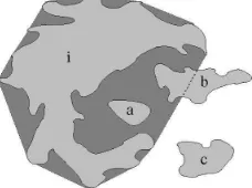
Betweenness, Convexity and Affine Geometry
Affine geometry concerns those properties that are definable from the relation of
betweenness. This includes the notion of convexity, since a convex region is one such that any point that lies between two points of the region is also included in the region.
For example, in Figure 2 we see an islandiand three smaller islandsa,band c. Of these onlyais convex. The convex-hull oficonsists ofiitself together with the dark regions surroundingi (which correspond to bays around the island). We see thatais completely within the convex-hull ofi,cis completely outside it andbis partly in and partly out.
Figure 2: example of a convex-hull
2.5
Direction and Orientation
[image:5.612.271.340.457.532.2]A class of spatial relationships that is particularly significant for GIS applica-tions is those relating to compass direction. The standard nomenclature for describing directions (N, S, W, E, NW, NE etc.) may be used to represent the direction of one point location relative to another; but, since the points may not be aligned exactly along a designated direction, this is normally adapted so that directions are associated with segments, rather than lines, as illustrated in Figure 3.
Figure 3: cardinal directions associated with segments
This scheme must also be modified if it is to be applied to extended regions, which do not lie on a unique line. To handle this case, it has been proposed that directions should be defined in terms of a grid, as illustrated in Fig 4. Here the white region lies to the west of the dark reference region, which defines the grid; and the mid-tone region overlaps each of the N, NE, E and SE sectors of the grid.
Figure 4: cardinal direction grid determined by a reference region
black disc) and reference landmark (the black triangle) determine a grid, by means of which we can characterise the position of another object in terms of whether it is to the left or right of the landmark and whether it is nearer or further away. Here, the white disc lies on the “right perpendicular” (rp) relative to the viewpoint and reference point; and the cross lies in the left centre (lc) region.
Figure 5: orentation relative to a landmark
2.6
Metric Geometry
[image:6.612.263.347.337.465.2]3
Spatial Inference Mechanisms
One of the main obstacles to the employment of automated spatial reasoning in practical applications is the complexity of computing deductions. Theoretical results show that even when dealing with information expressed using seemingly very restricted vocabularies of spatial concepts, the number of computational steps required to determine whether a given consequence follows is typically an exponential function of the amount of information involved. Thus inference computations performed on large amounts of data are likely to require huge amounts of CPU time and memory. To mitigate this problem, a number of special purpose procedures have been developed that are effective for computing certain kinds of spatial inference. But there is always a trade-off between the generality and computational tractability of any reasoning algorithm.
The rest of this section summarises some of the most widely used reasoning mechanisms that have been applied to spatial information.
3.1
Reasoning with Cartesian Coordinate Information
Cartesian coordinate representations enable qualitative relationships to be com-puted by numerical calculation. For instance one may compute whether a point lies within a polygon or circle, or whether two polygons touch or overlap. Such functions are widely implemented in spatial information systems. However, this is only a limited form of reasoning, in that the representation does not allow partial or general information to be expressed and does not support extended chains of inference.
3.2
Reasoning with Classical Formal Logic
The the notation of formal logic was developed by mathematicians during the end of the 19th and the first half of the 20th century (in particular by Got-tlob Frege (1848–1925 and Bertrand Russell (1872–1970). It provides general purpose mathematical tool for representing and reasoning with information for-mulated in terms of properties and relationships holding among any domain of entities. This representation can be used to formulate axioms constraining the meanings of the conceptual terms and the structure of the domain, as well as for specifying particular facts. Moreover, it provides a general mechanism for determining valid inferences that follow from any set of theoretical axioms and/or specific facts.
A number of theories of spatial entities and properties have been formu-lated using classical formal logic. For instance: Tarski’sElementary Geometry
is a fully formal specification of the Euclidean geometry of points; theRegion Connection Calculus is a theory of topological (and in its extended form also
logic. However, not all spatial properties can be adequately expressed in purely first-order logic (e.g. the continuity axiom of Euclidean geometry).
An advantage of using classical logic is that it has a well-defined semantics (formulated in terms of set-theory), and for first-order formulae a complete in-ference procedure can be specified. A major disadvantage is that the complexity of computing inferences it typically extremely high. Hence, unless the formalism is severely restricted, it is not usually possible to implement practical reasoning algorithms.
3.3
Relational Constraints and Compositional Reasoning
One simplification of the representational framework that has proved very ef-fective in making spatial reasoning problems more efef-fective is to limit the range of spatial facts under consideration to those expressed using a fixed vocabulary of spatial relations among entities. These are typically binary relations such as “ais connected tob” or “ris to the north ofs”. These can be seen as forming a network of constraints between entities. The reasoning problem is then confined to determining whether such a network is consistent or deriving new relations entailed by the given constraints.
Compositional reasoning is a general mode of deduction applicable to rela-tional information. Most often it is employed with binary relations, in which case deductions take the following form: from two relationsR1holding between
xandyandR2holding betweenyandz, we infer a relationR3betweenxand
z. Such reasoning has been found to be very useful when dealing with spatial in-formation. For instance, in the realm of mereological and topological relations, one can make compositional inferences such as:
• Ifxis part ofy andy is part ofz, thenxis part ofz. • Ifxoverlapsy andy is part ofz, thenxoverlapsz.
• Ifxis part of y andyis disconnected from z, then xis disconnected fromz.
3.4
Reasoning about Transitions
As well as providing a static description of the world, spatial relations may also be used to describe changes in the state of the world. Such change can be represented simply by a series of snapshots describing successive spatial config-urations. For example, at one time a desert region may be disconnected from a certain province, but later it might externally connect and then overlap that province.
continuous transitions among them can be represented as a graph, which is often called a transition network.
3.5
Reasoning with Ontologies of Spatial Concepts
Anontology represents the meanings of a conceptual vocabulary by expressing logical relationships between concepts, usually in some kind of formal language. Such formalisms will typically support inference by means of computational al-gorithm. A number of standardised formalisms have been devised for expressing ontologies. In particular, OWL (the Web Ontology Language) is an XML com-pliant representation based onDescription Logic, that is widely used to encode ontologies for usevia the World Wide Web.
One limitation of standard ontology languages, such as OWL, is that they do not in themselves support distinctively spatial aspects of reasoning. Logical connections among spatial properties and relations can only be captured in so far as they can be encoded in terms of the somewhat restricted representation provided and this may not always be possible.
4
Spatial Reasoning in GIS
The essentially spatial nature of geographic information means that there is considerable potential for the application of spatial reasoning within geographic information systems.
Traditionally GIS applications have represented spatial information primar-ily in a Cartesian form (i.e. as coordinatised points, lines and polygons). Thus, they do not support representation of partial or general information and cannot carry out extended chains of inference. However, it is increasingly apparent that more sophisticated GIS applications require more powerful spatial reason-ing capabilities. Representation of partial information is particularly needed for planning and hypothesis testing, where spatial constraints typically occur in a qualitative form (“the toxic waste dump may not be adjacent to a residential area”).
Spatial reasoning is also required for flexiblequery interpretation. Whereas a traditional GIS requires queries to be framed in a limited number of ways that are closely aligned to the way that data is actually stored, spatial reasoning can enable interpretation of queries involving complex combinations of a large vocabulary of spatial terminology.
relationships such as “a house is a type of building,” which would mean that house object would satisfy any constraints applicable to buildings.
The use of spatial reasoning in GIS is still (in 2006) at an early stage of development. But its potential is widely recognised and increasingly sophisti-cated reasoning components are already appearing in commercial GIS systems. There are still many challenges to meet in implementing flexible and effective reasoning algorithms. However, it seems certain that the use of automated spa-tial reasoning will transform the way that we use computers to interact with geographic information.
Suggested Further Reading
Cohn, A. G. and Hazarika, S. M.: 2001, Qualitative spatial representation and reasoning: An overview,Fundamenta Informaticae46(1-2), 1–29.
Egenhofer, M. J. and Golledge, R. G. (eds): 1998,Spatial and Temporal Rea-soning in Geographic Information Systems, Oxford University Press, New York.
Pratt-Hartmann, I., Aiello, M. and van Benthem, J. F. A. K. (eds): 2007,The Logic of Space, Kluwer.