PAPERS AND PROCE'EDINGS OF THE ROYAL SOCIETY 01'''' TASMANIA, VOLUME 88
The Geology of the West Coast Range of Tasmania
PART I: STRATIGRAPHY AND METASOMATISM
By
J. BRADLEY
SenioT LedllTer "in Geology at Victoria Unive?"'sity College, FVellington, N.Z.
(WITH 4 TEXT FIGURES AND 9 PLATES)
ABSTRACT
The 'Vest Coast Range is a monadnock mountain chain of Tremadocian and
older rocks. The Tremadoc strata were fault angle conglomerates which were
crushed in Devonian times between a Cambrian geanticline and the Precambrian core of Tasmania. Cambrian rocks are of spilitic lavas and macigno facies greywackes.
The Tremadocian strata are of Flysch and Molasse-like facies. Devonian movement
was largely on tbe line of upthrust of the Cambrian geanticline and aiong thIs same line intense metasomatic metanlOrphism dosely followed the Devonian orogeny. The juxtaposition of contemporaneous and later faulting with metamorphislP and
volcanic sedimentary and metamorphic breccias, provides interest. The two most
interesting problems concern metamorphic contacts which resemble unconformities, and the tectonic history of the area. The phenomena observed ean be welded into a eonsecutive story which is thought to be of world-wide application.
INTRODUCTION
This study is part of a wider programme of investigation into the mineral bearing region of Western Tasmania. The work, under the aegis of the University of Tasmania, has already resulted in descriptions of the stratigraphy and palaeontology of the Siluro-Devonian strata of the Zeehan district, by Gill and Banks (1950).
The Ordovician strata form the subject of another study; this article is concerned with the rocks and structures of the West Coast Range; with rocks which are in general of Cambrian age, unfossiliferous, metamorphosed, and cast in complex forms. In order to make a more complete picture of events, information has been supplied on districts outside the immediate area. This study is, unlike most petrological works, a field problem involving a high degree of structural interpretation. The results of field and structural studies are presented here, and at a later date a petrological and theoretical study of the porphyroid rocks and ore deposits will be given.
'" This work was performed while the writer was a Research Fellow of the University of Tasmania
193
SCALE
o 8 16 MILt~S
L....-....-._-.L...--.--.J
o Mr. S/$CHOFF
o LEVeN
GORGE
43° "r+"""l "
-FIG. l.---Locality map of part of
vVestern Tasmania. F'IG. 2.-Index map
of West Coast
[image:2.501.79.431.154.664.2].1. BRADLEY 195
LOCATION AND TOPOGRAPHY
The position of the West Coast Range is indicated in the maps, figs. 1 and 2, together with centres of mining and other localities men-tioned in the text. The Range occupies a belt of country fringing the western margin of the Plateau of Central Tasmania. To the east the Range is separated from the plateau by a depression in which the major rivers run, while to the west the Range gives way to a broad low-lying country.
Considering the slight elevation (4,000 feet) of the West Coast Range, and its small range of altitudes (3,000 feet), it is a surprisingly rugged chain. Several factors contribute to this ruggedness, namely, the extremely varied hardnesses of the strata, glacial erosion, and the rejuvenation of rivers. The Range is a monadnock chain rising from the Howards Pene-plain, a terrestrial erosion surface which falls from 1,000 feet at the foot of the Range, towards the coast. The surface of the plain is gently undulating and relieved by low quartzite monadnocks at Sisters Hills and Mt. Professor. Inland it forms the tops of the low 1,100 feet hills of the Andrew and King River Basins. A second erosional surface is the Henty Peneplain of Gregory (1903). This stands between 400 and 500 feet lower than the first and is the level of the old flood plain of the King River, and the flat valley floor of the Queen River. The coast of Western Tasmania is, apart from Flandrian drowning, emergent, and some of the uplift near Temma is very recent. There is abundant topographic evidence that the main uplift of the Renty Peneplain is relatively late, certainly post Pliocene. The rivers show all the characteristics of rejuvenation--gorges, rapids, falls, and discordant junctions. The heads of rejuvenation
of large streams are situated, at relatively high altitudes, at short distances from the sea. The King and Henty rivers, for example, fall 600 feet and 500 feet respectively in the last twelve miles of their courses. In the case of the King River slow downeutting eould be caused by barriers of quartzite which cross its course, but this is thought to be of seeondary importance compared with lateness of uplift. Even the Howards Pene-plain as a whole is at an early stage of dissection, and in this surface it
is only the largest streams and rivers which have cut deep gorges. Between the King and Henty Rivers half the original land surface is undissected. This, in an area of IOO-inch rainfall and of relatively unresistant rocks, suggests late uplift. The old surfaee is tilted sea wards but does not reach to sea-level; it is interrupted on. a line about one mile east of Strahan by a sudden drop to 200 feet. where it meets a horizontal :mrface of estuarine deposits. The line of contact of these surfaces is probably an old cUffed shore and an old fault line.
pro-nounced erosional surface oecurs at 2,750 feet; this is very prominent in the area east of Mt. Dundas, and remnants of it are present on Mt. Darwin, Mt. Farrell, and over much of the country east of the West Coast Range.
GLACIATION
Some of the glaeial features of the Range are very fine and even exceptional. In the high eountry evidence of glaciation abounds, but nowhere is there a mature glaeiated landscape. Only on Mts. Murehison and Jukes did eirques meet to form aretes; elsewhere glacial erosion is even less mature. The Huntley cirque, eut in white quartzites and with a circular plan, is a typieal example of biseuit eutting, and the erosion in the rest of the Tyndall Range, while it is the most extensive of the region, is of this type. Old valleys were ice-filled to plateau level, some were over-deepened and lakes, notably Lake Rolleston, were formed in them. Below .2,000 feet, and with the exception of Lake Spicer (900 feet), no over-deepened lakes and few glacial erosional forms occur. During the Pleistocene, the eastern side of the mountains was the lee side, as now, and it is there that cirques and ice-sharpened cliffs occur.
The largest of the glacial phenomena is the mammilation of the country of the Upper King Valley. This area, at 800 feet to 1,500 feet, was swept by an ice sheet which, descending from the Eldon Range, rounded off the hills and left tills and moraine which can be seen along the Lyell Highway. The ice travelled for a further three miles south, gouging out the cliffs of LittIe Owen (670/180), and leaving a heavy moraine at 670/160. No end-moraine now exists across the centre of the King Valley. This ice sheet must have piled up to a thickness of 700 feet at the King Bridge, for it backed up the ice of the Comstock and Linda Valleys, and some meltwater overflowed to the west. At Gormanston the varves, formed in the small lake extant before the melting ice, reached up to the level of " The Gap ", which was an overflow channel. Gregory's (1904) statement that the King River ice passed west of the Linda Valley is not borne out by the nature of the topography. In the Comstock Valley the limit of the ice is marked by the terminal moraine on the track to the Comstock mine. At the western end of the Comstock Lake the overflow cut a deep channel which is now occupied by the head of the West Queen River.
J. BRADLEY 197
shaped, it cannot have been long occupied by ice. According to Lewis (1945), ice reached to sea-level at Malanna, but for evidence of this, in all the area of the Howards Peneplain, I have found no glacial erosional features nor glacial deposits. Gill and Banks (at Firewood Siding, Malanna) described Permian tillites which in a weathered condition look like Pleistocene till, and were probably taken to be of that age by David and Lewis (Lewis 1945).
DRAINAGE
The drainage system is closely related to the solid geology. The broad patterns of rivers are commanded by fold structures in the hard Cambrian rocks and the softer post (;ambrian strata. The older rocks form the anticlinal core of the Range. The younger rocks overlying this core are stripped away, and along the flanks of the Range the Ordovician limestone is reduced by solution to below base level. Consequently the lofty Cambrian country is surrounded by wide swampy flats in which wind the King, Queen, Andrew, Sophia and Mackintosh rivers. In the centre of the broad synclines east and west of the Range the Siluro-Devonian sediments are reduced to low hills. Minor streams are closely controlled in trellis fashion, following the north--west and north-east joint patterns of the country. Middle courses of the larger rivers are incised following the Henty uplift, and the lower courses have super-imposed, mature patterns. The striking cross cutting relation of the King River to the West Coast Range is due in part to this superimposing. The river does; however, follow a structural low, and it must once have flowed only 500 feet above its present bed in a syncline of limestone. To the south, a much readier outlet exists for the waters of the King Basin through the low valleys of the Baxter and Andrew rivers. This is demonstrated by the recent capture by the Andrew of the headwaters of the Baxter, and the pending capture of the King. It appears that a much larger Baxter River must once have flowed north in order to have formed the mature valley which occurs near the Andrew Divide. The cross cutting relationship of the Mackintosh River to the Range has an explanation similar to that of the King, but this river is not appreciably incised. The Pieman River, into which the Mackintosh flows, is cut 200 feet below its old plain, and much of its course is unrelated to the structure of the country.
The Henty drainage had a base level about 400 feet above the present sea-leveL The erosional eycle prior to that (the Howards)/ must have been very long. The ruggedness of the Range is most deceptive when estimating lengths of erosional periods, and the extreme chemical degrada-tion of all but the quartzite rocks is the best index of the duradegrada-tion of that earlier cycle.
PREVIOUS LITERATURE
(1905), who summarises the views of workers prior to that date. He gives an excellent history of the field, and description of the topography and climate. In the same area Hills (1913), Edwards (1939), and Conolly (1947), have made notable contributions to the geology. Hills first established the stratigraphic. relations of the Cambro-Ordovician sediments and identified the main structures. Conolly has brought the structure at Lyell to a comprehensible stage and Edwards has given an account of mineragenesis. Tasmanian Survey officers have described other mining fields as follows :-Ward--Mt. Farrell (1908), Waller-Zeehan (1904), Hills--Darwin and Rosebery (1913 and 1914), and these accounts are referred to below. Before proceeding any further I must express my admiration for the work of the older geologists who have been a constant source of information through their faithful observations.
Maps of the area are :-the 4-inch to 1 mile sketch map by the Mines Department, and the 4 miles to l·inch sheet, No.3, by the Lands and Survey Department. Trigonometrical information is by courtesy of the Hydro-Electric Commission of Tasmania. The maps appended have been constructed wholly from aerial photographs (20 chains to 1 inch) by the writer, and produced by the Geology Department of the University of Tasmania. The maps of the area north of Lake Margaret await the availability of aerial photographs, and it is hoped to publish them in one year's time. Map references scattered in the text refer to the grid on the maps appended.
ACKNOWLEDGMENTS
This work was executed by me while a Research Fellow of the University of Tasmania, and I wish to express my thanks to that institu-tion for financial support and the printing of the maps. l\;ly special thanks are due to Professor S. W. Carey for his advice and help. I wish to acknowledge also the friendship and valuable criticism of Dr. C. Loftus Hills and Mr. M. R. Banks, the drafting assistance of Miss June James, the companionship given me in the field by my friends, especially Mr. F. Brown, and the courtesies offered me by several mining companies. The Mt. Lyell Mining Company in particular has been most helpful in giving full access to their maps and property.
INCIDENTAL STRATIGItAPHY
In this analysis it is primarily the Owen Conglomerate, the Dundas Group, the Porphyroid rocks and the structure which are of interest. These are treated in detail. Ordovician, Silurian and more recent rocks are used only as keys to structure, and are treated in detail only where they have particular interest.
RECENT
J. BRADLEY 199
PLgISTOClCNg
The most extensive Pleistocene deposits are the well-preserved river terraces of the middle course of the King River. They are aggradational deposits up to 100 feet thick and vary in texture from boulders to sand. '1'he terraces are dated by a dry overflow channel which issues from the Toft V alley and cuts the highest of them. The absence of moraine across the main part of the valley, and the general form and age of the terraces, suggest that they are of fiuvioglacial origin.
Of exceptional interest in Australia are the varves at Gormanston. They cover 10 acres and extend discontinuously over 300 feet of height, but are much leRs than that in thickness. Being highly variable, ill-graded, and containing numerous lenses of sand, gravel and dropped pebbles, the beds are not ideal examples of varves. It is probable that the Linda Lake was very limited and existed only at this one end of the valley and that the numerous drag structures of the varves are due to grounding and over-riding of advancing ice.
TgRTIARY
Ineluded here as latest Tertiary, and named Macquarie Beds, are the estuarine deposits bordering Macquarie Harbour. These are uncon-solidated pebble beds, blown sand, lignitic coal seams and seat earths. Near Strahan 200 feet of beds dip gently west and pass below the water. On the western slopes of Mt. Sorell the beds standing at 400 feet also dip west. Around the harbour the formation is cliffed back, while inland there is an incipient dendritic dissection. Many of the valleys cut in the gravels are rounded off, grass coven~d and dry. At present the porous pebble beds appear able to dispose of all the rain, 40 inches, which falls on them. Presumably the valleys were cut at a time of
rainfall or lower altitude. Around the Harbour and parallel the shore run small folds which are slump structures consequent on cliffing. The effect of this slumping extends 50 yards I)ack from the shore, as shown jn the small faults of the railway cuttings east of Strahan. The dips at Strahan are, however, too consistent and strong to have this cause or to be initial dips. Rather, the beds appear to have been tilted and raised. Their uplift probably coincides with that of the Henty Peneplain and is possibly Pleistocene. No shelly fossils occur in the strata, but numerous plant remains may ultimately decide their age.
MESOZ01C INTHUSIVgS
The small remnants of columnar dolerite capping .ThUs. Dundas and Sedgwick are clearly part of the basal sill of the plateau of Tasmania, and are post Triassic in age. The Sedgwick rnass is described by Edwards
(1942) as a quartz dolerite.
PERMIAN
SILURO-DEVONIAN
Sediments of these periods constitute the Eldon Group of strata. They are arenaceous and argillaceolls sediments overlying the Gordon Limestone. The uppermost limit of the group is undefined, as the strata are everywhere folded and eroded. At Zeehan, the type area, the forma-tions of the group have been defined and described by Gill and Banks
(1950), as
follows:-Lower Devonian
Silurian
Orogeny
i Bell Shale . ... . ...
l
Florence Quartziter
Keel Quartzite ... .i
Amber Slate ... .l Crotty Quartzite
Disconfonnity
1400' 160n'
400' 800' 1600'
Gill (1950) identifies the Bell and Florence Formations as Lower Devonian in age, and provisionally draws the line between Silurian and Devonian at the base of the Florence Quartzite. He adds a proviso that the Keel and Amber Formations may also be Devonian. In the latter case there would be a considerable gap in the Silurian sequence. Despite this possibility there is usually no discordance between formations, and observations over a wide area indicate uniform condition of deposition for each formation. This is very clear, for example, in the case of the Crotty Quartzite, which over a distance of 40 miles is immediately recog-nisable by its lithology. The Keel Quartzite is also striking, as it forms a sharp ridge in all of the West Coast area. The Florence Quartzite is readily identifiable on the western side of the Range by its hummocky outcrop. In the King Valley it is not so readily identified from topography. In the same area the Bell Shale, which normally forms a negative feature in the Zeehan area, is also unidentifiable by any characteristic landscape form. This is because the pelitic formations of the King Valley are often slates. This is the case, for example, on the Lyell Highway, where the Bell Shales become a positive feature (3695/8195).
J. BRADLEY 201
It will be apparent at this stage that the complete geomorphic adjustment to structure of the varied Eldon strata provides an ideal medium for photographic interpretation. Add to this the striking negative topography of the Ordovician limestones and the bold relief of the Owen Conglomerate, and there exists an area which for topographic interpreta-tion of complex structures is unexcelled in any forested country. In the case of the Eldon Group it is generally possible, despite forest, to trace formations on photographs for many miles. Interruption by fault-ing is frequent, but little difficulty is met in matchfault-ing beds and elucidatfault-ing structures. The identification of formations and interpretation of struc-tures are simple integrations of each other. The structural picture obtained by photographic mapping, assisted by lithology and dips, can be brought to a high degree of perfection.
Of the Eldon Group the Crotty Quartzite, whose recognition in the field is important, has some interesting features. The formation name derives from Crotty town (3675/8065) where the sandstone was first noted by Hills, but the recently formulated definition given by Gill and Banks (1950) at Zeehan is accepted. At Crotty Station the formation is well exposed. In descending order three members are
recognised:-(1) The Upper Tubicolar Sandstone. 200 feet. This is a porous white
quartz sandstone with grains 0·5-1·0 mm. and bearing" pipe stems".
(2) Variegated Beds. 200 feet. These are very friable, pink, white, and
green sandy shales and laminated sandstones; grain size less than 0·5 mm.
(3) Smelters Sandstone. 400 feet. A dazzling white, very friable and pure quartz sandstone. Grain size 0·5 mm. plus.
These sandstones are coarser than any other of the Eldon Group. They differ from the Crotty Quartzites at Zeehan only in that they contain no grit bands. Bedding is less regular than in other Eldon quartzites and cross bedding is common. The sandstone was calcareous, but the long exposure of the rock to peaty and sulphated waters has removed every trace of calcite. This accounts for the friable nature of the rock which on occasion is reduced to heaps of rubble. A common erosional slump breccia character of the rock is due to the same process of solution which removes the underlying Gordon Limestone. This occurs on an enor-mous scale on the roadside opposite the Lyell Smelters and produces anomalous structures. Such structures at the Queenstown Quarry resemble planes of unconformity or of thrusting.
The Tubicolar horizon, which here is distinguished from that in the Owen Conglomerate by the name Upper, represents a phase more than ordinarily caleareous. The" pipe stems" described by Ward at Zeehan as being parallel to bedding are, at Crotty, normal to the bedding. They have been described as casts of worm tubes or crinoid stems. I have found this bed to be very extensive and a consistent and useful marker horizon. The variegated beds are also useful in this respect as they are relatively rich in iron and stand out as bold bands in the sandstone.
lime-stone are compatible with unconformity at this juncture, and the calcareous character of the sandstone could be attributed to incorporated limestone fragments. This possibility is thought to be slight. An interesting variation in the sandstone is its thinning from Zeehan to the south; from a reported 1,600 feet at Zeehan it falls to 1,000 feet at Queenstown and 800 feet at Crotty. On the King River section, towards Strahan, I cannot easily recognise it. Similarly, at Kelly Basin, the formation, though recognisable, is thin or is changing character.
ORDlVICIAN
The Ordovician is almost fully represented by the Gordon Lim'3stone, which over most of the area extends from the Tremadocian upwards. The Tremadoc strata are in the main the Owen Conglomerate and are treated in detail separately below. The Gordon Limestone has not yet been clearly defined and this name, used on the suggestion of 11. R. Banks, is an abbreviation of the customary" Gordon River Limestone".
The formation has been traced round some 100 miles of outcrop by me, and at least twice that distance by Professor S. W. Carey. Its identity as one bed overlying the Owen Conglomerate is no longer in doubt. It is different from the section on the Gordon River at the Great Bend in respect of thickness, and probably of time range. In the West Coast Range its thickness is 700 feet as compared with 3,000 feet on the Gordon River. This is largely accounted for, in my opinion, by a transgressional relation from south to north, and by the replacement of the underlying Owen Conglomerate to the south by limestone. It may be that the Crotty Quartzite was later formed under conditions of regression, and that it, like the Owen Conglomerate, passes out to the south into limestone. Despite Gill's inelusion of the Crotty Quartzite with the Eldon Group, I anticipate that a large time-break will be found above, rather than below, this formation, and that Hills and (1949) inclusion of the Crotty in the Junee Group will prove to be a more reasonable arrangement. To the south of this area I expect there will be no Crotty Formation overlying the thicker limestone. The lithology of the limestone cannot be well described from this area as exposures are so poor. Excepting larger exposures on the Nora River, on the Nelson River, at Lynchford and Bubbs Hill, there are probably not twenty exposures of limestone of a total area of one acre in twelve square miles of " outcrop".
At Zeehan, recent mine draining has lowered groundwater sufficiently to reveal a very rugged karst topography formed below the water table, with solution channels hundreds of feet below. Such a radical base levelling is the general fate of the limestone, which is traced everywhere by boggy fiats carrying a black, carbonaceous? residual clay. The recog-nition of the Crotty Quartzite and the Lower Tubicolar Sandstone are consequently more than ever important, as these sandstones indicate the presence and the thickness of the limestone. Such thicknesses as are given can therefore rarely be accurate within feet, and, because of the slumping of the overlying strata, often have less accuracy than
J. BRADLEY 203
coarse grained. At Lynchford Quarries it is pure, massive, and without bedding or many fossils. At Queenstown Quarry, and neal' its base, the limestone is impure and rhythmically banded with black shales. Here and across the river from the quarry it is highly fossiliferous; Hill and Edwards (1941) describe Ordovicion fossils from that locality, and Mr. M. Banks informs me that the latest collections show the limestone to extend fwm Lower Ordovician to Lower Silurian. On the Nora River great thicknesses of the limestone are very impure and may be more correctly called carbonaceous and calcareous shales. In this area (3648/7900) it is clear that the Lower Tubicolar Sandstones interdigitate with, and pass laterally into, the calcareous shales. The limestone, in the distance of three miles, south of that area, increases in thickness from 800 to 1,800 feet.
The base of the limestone has never been described previously. During the dry summer of 1950 it was possible to examine exposures at the head of Lake Margaret where Nye had previously reported limestone. The islands at the head of the lake, and the bed of the lake, were left high and dry. Limestones there an~ basal and transitional. They show the following
sequence;-Limestone 4 ft.
Limestone 40 ft.
Shales 6 ft.
Sandstone 2 ft.
Gap 10 ft.
Sandstone 40 ft. Quartzite 60 ft. Conglomerate 100 ft ..
Dark. medium grained, with numerous bryozoa. Impure dark-grey limestone weathered to yellow sandstone with tubercles normal to bedding. Yellow to black with many recumbent and
graphitic tubercles parallel to bedding. Yellow friable sandstone with small tubercles
normal to bedding. Apparently eroded shale.
vVhite quartz sandstone. Dense white quartzite. Grits and fine conglomerates.
[:::;::::1
TERTIAHY MESOZOICr '/ '/
~ DOLERITESILURIAN _. DEVO~~IAN
c=J
ELDON GROUPORDOVICIAN
~ GORDON LSTNE.
~OWEN CONGo
SCALE
o 2 J 4
! t ! I
..
. . .
· ..\
.--:--:-" .. . ~ .--~.
. .
.
.
.
.
·
. . . \-: ..~ • • . - l . • •
· ... '"
. ....
~\ .... ,·
~. .
. .·
. . . • • 0 • • •·
· ...
. . . . .)..
• • • • • ct 0 ·
...
~. "h:
• • • • <l:
· . . . .
·
.... ;....'"
FIG. 3.-Geological sketch map of the area shown in Fig. 2.
SCALE
0 2 J 4 S 6 7 MILES
I I
,
I0
/
0 0.(
I
ctI
i:'i 'l:I
'"
'"
....
~
'"
I
>< ct
0 0
't Cl
I
& (,
'< 0
'II
I
I
\.
I
\\
0\
_ 0
..,
~
\
_ 0 0 ....
0 0 0
-'"
"< 00 ' " \ Cl 'II
'"
<1:\
:\
\
\
Ii:'"
...."-<l:
\
0 0
\
i::i...,
I~
\
'"
-.:\
'"
~\
::,
Q
'"
I
~ .... u ~I
).. VI~)
I
0 '~ (, \ !2 \ \ \_l
[image:12.499.63.427.146.661.2].T. BRADLgy 205
THE OWEN CONGLOMERATE LITHOLOGY
DgFINITION
The West Coast Range or Owen Conglomerate is a quartzose con-glomeratic formation occupying the outcrops shown in Figs. 1 and 3. It lies principaIly in a narrow belt with little longitudinal variation in thickness but with a marked lens shape from east to west. Fig. 4 shows the estimated and deduced thicknesses of the formation in the West Coast Range. Outliers of similar but finer conglomerate occur to the west at Mt. Zeehan, Mt. Professor, Mt. Misery and Sisters Hills, and to the north are exposures at Howth, Dial Range and Leven Gorge. East of the Range thin sandy conglomerates occur at Hawks Creek, on the Sticht Range and Engineer Range, while to the south and south-east are exposures at Tim Shea, Adamsfield, and on the Denison and Elliot Ranges. Repre-sentatives occur, therefore, over an area of 150 by 100 miles. While it is probable that the uppermost sandy members once extended over this wide area, the conglomerate proper was laid down in distinct synclinal, fault, or erosional troughs of which the vVest Coast Range, or Jukes, Trough, bordering an old land, was the largest.
The conglomerate has long been loosely recognised by Survey ofikers as a formation. The earliest statement giving a name to the formation is that of Officer, Balfour and Hogg (1895), who published an adequate definition of the "Owen Conglomerates" occurring on Mt. Owen. In 1908 Ward further suggested that the conglomerates capping the Range were one formation, but the first precise account of any kind was that made by Hills (1918) on the succession at lVIt. Jukes. Hills described the formation, which he called the West Coast Range Conglomerate, in dear accurate detail, and his description I have presented in a tabulated form below. Hills's section, a representative one showing the maximum development of the formation and most of its characters, runs as follows
:.-Tubicolur Sandstone: yellow sandstone with pipe sterns
Chocolate Sandstones: alternating thin beds of conglomerate, sandstone, and shale
White Conglomerates: quartz pebble beds with 1 to 2 inch rounded pebbles
Red Quartzite: Red or pink quartzite, fine grained, very hard, massive, but often fissured and veined
Red Conglomerates: Red quartzose beds with pebbles up to 6-ineh diameter and often with haematitic cement
Breccia Conglomerates (= Jukes Breccia): Coarse breccias with
angular to subangulal' fragments up to 4 feet across. Princi-pally of porphyroid and slate fragments with subordinate
quartz or quartzite. Usually deeply stained
Unconformity against underlying Porphyroid rocks.
400 ft.
400 ft.
400 ft.
400 ft.
400 [1.
300 ft.
formations in the basal breccias. The description is a faithful one and is acceptable except for an important qualification concerning the uncon-formity.
Hills has excellent grounds for supposing unconformity and in a general sense his statement is true. The writer would deduce unconformity near this juncture and in this vicinity, but it cannot be claimed that a clear unconformity is observed. The writer considers the contact to be metamorphic and not sedimentary. The discussion of this point must be delayed while a general picture is given.
The Owen Conglomerate is, as one would imagine from its con-glomeratic nature, a variable formation, and from its distribution and thickness, has variable contacts with underlying strata. Further, much variation in its members is to be expected, and a type seetion cannot strictly describe the formation. Definition of the formation, as distinct from what is recognised as a description of a type section, can only be arrived at by qualifying the kind of variation from the norm which is to be allowed. The following criteria and qualifications are thought useful for defining the formation as a
whole:-1. The formation on grounds of priority and simplicity is to be called the
Owen Conglomerate.
2. It is of Tremadocian Age (Hills and Carey (1949, p. 27).
3. It is essent;ally quartzose. As this formation and some others are commonly
silicified, this statement is qualified by requiring that the Owen
Con-glomerate contains more than 75 per cent of original quartz or quartzite
particles.
4. It is normally conglomeratic but may contain shale and quartz-sandstone
beds. Where the formation passes into shales it loses its identity, but
where it passes into sandstones the name is retained.
5. It is limited above by the Gordon Limestone Formation. That boundary is often gradational but is normally fairly sharp at the Lower Tubicolar Sandstone.
6. The lateral sedimentary limits of the formation
are;.-(a,) By transgressional unconformity.
(b) By passage into shales and Gordon Limestone.
(c) By passage into contemporaneous greywacke conglomerates and
sandstones.
7. Its lower limit is defined
by:--(a)
(b)
Unconformity; basal breccias may oj' may not be present. In the absence of unconfol'mity, by a change in composition from
greywaeke type to quartzose sediments. The basal breceias
are not always present, but there are very few cases where the change is not abrupt.
8. It may be limit·ed laterally or terminate below by contact with
meta-morphosed rocks.
All of these conditions have been observed. The thickness of the :::ormation ranges from zero to 2,000 feet and has no definitive value.
:;ENgRAL
J. BRADLEY 207
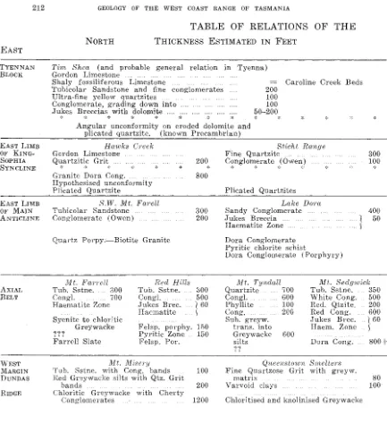
Unfortunately, there can be little stratigraphic detail, because correlation of members inside of the formation is rendered very unreliable by the powerful transverse faulting and subsequent erosion which cuts the country into separate blocks. There are no fossils in the rocks and " walking" of beds is out of the question. There remains" bed for bed" correlation of the several blocks of country. Some results can be obtained by this method, but when it is considered that the east-west variation in thickness of the formation is from two thousand feet to zero in as little as six furlongs, it is rash to suppose that there is a vastly better con-sistency from north to south inside the formation. There are, however, some general observations which are useful, and some large unbroken blocks of country show the kind of continuity which can be expected. There is, in fact, a surprisingly consistent variation in the Owen Con-glomerates, both vertically and longitudinally. Comparative sections have been drawn up, in the accompanying table, which show the broad character of the formation. A fuller account follows :
-PARTICLE SIZE
There is a decrease in pebble size from bottom to top of the formation. The basal breccias are always the coarsest and fragments are generally from six to eighteen inches across; fragments up to two feet are not unmmal. The basal breccias are very unevenly sized, and resemble the deposits of a cliffed shore in a hard-rock terrain. The lower members of the Owen Conglomerate are of very even-sized quartz and quartzite pebbles which are rounded, slightly oblate or ellipsoidal, and six to nine inches long. The upper half of the formation shows decreasing grain sizes towards the top, and the gradually diminishing conglomerate bands are of pebbles two inches or less across. The pebbles are rounded, spheroidal, and are wholly of quartz and quartzite.
There is an increase in sandy members towards the top of the forma·· tion and, if the middle Red (Juartzites are ignored, the gradation from coarse conglomerates to fine sandstones is very smooth. The Chocolate Shale is the finest member and consists of shale units which range up to 20 feet thick, alternating with grit and sandstone, in bands up to two feet thick.
thickness of white grits and fine conglomerate, but in the short distance to Mt. Sedgwick the sequence changes until it is very similar to the section of Mt. Jukes. It is possible to draw an east-west line through Lake Margaret to separate two areas in which conglomerates have an appreciable difference of pebble size. In each of these divisions there is a fair degree of consistency of members.
SILICIFICATION
The Owen Conglomerate is almost everywhere cemented into a solid mass by a cherty or ehalcedonic matrix. This is most clearly demonstrated in Ioealities like that on the roadside near Gormanston, where road euttings show freshly blasted surfaces. The matrix there is dense and dark so that dark pebbles lose their identity in the mass, and the whole resembles specimens of the Hand Banket. There is a gradation of silicifica-tion which proceeds from intense in the lowest beds to less intense in the highest. This may simply be related to the original variation in perme-ability of members or it may indicate a deep seated souree of silidfying solutions. It happens that the uppermost quartzites are often unsilicified and, in particular, that the bands enclosed in the Chocolate Shales are frequently unsilidfied. Occasionally silicification reaches up into the Gordon Limestone, forming a porcellaneous creamy chert (3648/790). When fragments of similar chert are found in the higher conglomeratic beds, as they are at Tim Shea and near the Comstock Mine, it may be suspected that the conglomerate was not originally exclusively quartzose. In the lower beds chert pebbles never appeal', but it may be that some few quartzite pebbles are coarse grained replacements of slaty material. Other-wise the exclusiveness of siliceous pebbles in the formation is inexplicable. The sarne explanation attaches to some of the fine grained quartzites which have microscopic grain sizes. Some look like current-bedded silt-stones, but the yellow quartzites at Tim Shea look like finely banded shales. The laUer are probably replacements, but it is impossible with some rocks to decide whether recrystallisation or replacement has been most important in their formation. On the whole, the quartzites were originally quartz sandstones, but a secondary origin must always be considered for the very fine quartzites.
WEATHERING
J. Bl~ADLEY 209
HAEMATITE STAINING
This also decreases upwards from the deep blue basal or contact rocks through the rose-pink and white conglomerates. The finer grained sediments are deeply stained irrespective of their position, and some of their colour may be due to an original high iron content. Staining, even in these beds, is always more intense when they happen to be close to metamorphic contacts. Thus, the Red Quartzite of Little Owen becomes purple when it lies in contact with the porphyries, and the Chocolate Shale in the North Lyell open cut is wholly replaced by haematite schist. The blue staining in the contact rocks is effected by haematite which occurs in masses or is diffused into the outer shell of quartz pebbles. The pink pebbles also show a shell, about 2 mm. thick of pink quartz, and inmost quartzites the rose colour is completely diffused. Rather different is the colour of the Tubicolar Sandstone which is, except when close to a contact, yellow, due to iron hydroxides. As the hydroxides leach readily the Tubicolar Sandstone is often white.
CONTEMPORANEOUS MOVEMENT
At one locality an angular unconformity of 30° occurs at the base of the Tubicolar Sandstone. It is well exposed at the foot of the old haulage near Linda and has been mapped by Conolly and myself for about 200 yards. It is probable that the structure lies along a contem-poraneous fault scarp and that slumping, or drag, and erosion have created a purely local unconformity. At the top of the haulage and along the track to West Lyell open cut occur some fine sandstone dykes. These dykes run through the conglomerate, about 90 ft. below the above mentioned unconformity. They are up to 50 ft. long and pass out of the conglomerate into the adjacent schists. The dykes observable in 100 yards of contact are up to four inches wide and are twelve in number. The infilling is of fine pink sandstone without bedding. These dykes, while straight in th€ conglomerate, have been intensely contorted and broken in the schists. These structures alone suggest the
following:-1. That there was contemporaneous movement which fissured the conglomerate.
2. That the schist-conglomerate contact is neither intrusive nor faulted.
8.
Either-(a) the contact is an unconformity; or
(b) the eontaet is metamorphie; i.e., the eonglomerate has been
replaced leaving the sandstone dykes unaltered.
4. That some plicating movement oceurred at a later stage on the lower
side of the contact line and that this movement and associated schisting post-date the conglomerate.
Slump structures in the conglomerate are unusuaL They are very pronounced only in one area, on the Dora tram south of Lake Julia. There they occur in the transition beds at the base of the conglomerate. While they are individually only small, the movements are numerous and repeated over and over, and slumped beds are separated from other slumped' beds by unslumped material. This kind of slumping is characteristic of active orogenic belts.
REACTION TO TECTONIC FORCES
Where the Owen Formation overlies plastic beds as at Mt. Tyndall, it has behaved in a competent fashion. Where the underlying rocks were the hard Cambrian strata the thrusts now pass from these rocks and die out into folds in the 1,500 ft. thickness of conglomerate. While the pebbles are rarely, if ever, drawn out, there must have been much move-ment of pebbles; this is rarely obvious. Where pebbles lack sphericity their rotation can be observed and can be associated with the drag on particular faults. This is true of the Lyell Shear at South Darwin Peak; as rotation would be impossible in a silicified rock it can be postulated that silicification postdated this fault. Similarly, the absence of drag shears in most folds points to the same conclusion regarding folding. On the other hand, the brecciation of silicified conglomerates at Comstock and North Lyell means that some movement, particularly on north-east faults, postdated or was contemporaneous with silicification. Hills remarked on the strong fissuring of the Red Quartzites as compared with the conglomerate beds; that difference reflects the different abilities of the beds to transmit shearing forces. Even if there were no differential metamorphic effects it is evident that the pebble beds, with so little matrix, would react under compression or shear quite differently from other strata. 'I.'hey could conform like a layer of ball bearings while beds below were schisted and those above were occasionally converted to slate.
THE JUKES l'ROUGH
The regular grading of the individual members of the conglomerate formation rules out a fluviatile origin for it, and the coarseness and small amount of fine matrix in the lower beds rules out an origin by deposition on a sheltered sea coast. The environment was one of swift currents which rounded pebbles and swept away fine debris. It is imagined that there was a fault coast along the western margin of the Tyennan Block, and that the deposition basin was a narrow strait separat-ing that coast from an island chain some four miles offshore. It is conceived that the trough continuously subsided along its western margin and that thick deposits were formed there. The trough can be roughly divided into an area north of Lake Margaret, where sediments were, on the whole, finer, and one to the south where they were coarser. Further south the strait passed out into open and deep water. The trough is named the ;rukes Trough and the offshore chain the Dundas Ridge. The latter appears to be related to the Bischoff Anticlinorium (Carey, 1953, p. 1119 and Fig. 3).
'rHE BASE OF THE OWEN CONGLOMERATE
J. BRADLEY 211
Typically, the breccias are less than fifty feet thick and are a heterogeneous unbedded mass of unsorted angular and sub angular material. Fragments are huge boulders, blocks and slabs of granite, porphyry, schist and slate which might have been locally derived, and of quartzite, haematite schist and massive haematite which appear to be exotic. In the Jukes Trough the Owen Conglomerate is conformably underlain by greywacke conglomerate, and it appears that the breccias were derived from low fault scarps along each side of the trough. The complete change in the fill material of the trough implies movements over a vast area, movements which at once cut off supplies of greywacke and instituted a source of coarse quartzitic detritus, movements which must have almost
submerged the Dundas Ridge while elevating the Tyennan Block. It is
readily conceived that an even earlier rise of the Dundas Ridge must have produced an unconformity at the base of the greywacke conglomerates. Some confusion has arisen from the fact that Hills and Carey correlated (1949, p. 25) the greywacke conglomerates on the Lyell Highway above the King River Bridge (towards the Linda Valley) with the Jukes Breccia on Mt. Jukes, whereas only the upper part of this conglomerate should 'be correlated with the Jukes Breccia. The writer proposes that the lower part of this Lyell Highway section, i.e., the greywacke conglomerate, be taken as a separate formation. This will be called the Dora Conglomerate. The Dora Conglomerate is widely exposed in the glaciated surfaces of the type area around the shores of Lake Dora and for half a mile to the east and west of the lake. The formation is of Upper Cambrian age and lies conformably below the Jukes Breccia but this conformity is expected to pass into unconformity in places. The formation is inferred to be unconformable on Middle Cambrian and on Precambrian strata. The formation is characteristically an ill-sorted greywacke conglomerate with much fine matrix. Pebbles, which vary in size from one to six inches, are rounded and, though tabular or elongate, are not angular. The top of the formation is normally marked by a clean break from, or
rapid transition into, the Jukes Breccia. The base of the formation
is not definable owing to metamorphic transition. The full thickness of the formation may be very great, and at Lake Dora it is probably between 2,000 ft. and 3,000 ft. thick. As it is probable that the formation was deposited in a trough on one side of the Dundas Ridge it is distinguished in this paper from the Lynch Conglomerate of the Queenstown area, which was deposited in a separate basin on the western side of the Ridge.
The Jukes Breccia is regarded as the basal member of the Owen Conglomerate. It is a breccia which is characte:dctically coarser than the overlying conglomerates and contains quartz fragments. The Jukes Breccia often contains material common to underlying formations and
is usually intensely haematite stained. It is unconformable on Precambrian
EAST
TYENNAN BLOCK
EAST LIMB OF KING-SOIPHIA SYNCLINE
EAST LIMB OF MAIN ANTICLINE
AXIAL
BELT
TABLE OF RELATIONS OF THE
NORTH THICKNESS ESTIMATED IN FEET
Tim Shea (and probable general relation in Tyenna)
Gordon Limestone
Shaly fossiliferous Limestone Caroline Creek Beds
Tubicolar Sandstone and fine conglomerates 200
Ultra-fine yellow quartzites 100
Conglomerate, grading down into 100
Jukes Breccias with dolomite ., ... , .... .... 50-200
* *
*
*
*
*
*
*
*
* *Angular unconformity on eroded dolomite and
plica ted quartzite. (known Precambrian)
Hawks Creek
Gordon Limestone
Q~,artziti; Grit:
Granite Dora Congo Hypothesised unconformity Plica ted <C2uartzite
*
S.W. Mt. Farell
Tubicolar Sandstone Conglomerate (Owen)
*
(~uartz Porpy:-Biotite Granite
}lIt, Farrell Red Hills
Tub. Sstne. 300 Tub. Sstne.
Congl. 700
Haematite Zone Brec.
Haematite Syenite to chloritic
Greywacke Felsp. pOl'phy.
1?1 Pyritic Zone
Farrell Slate Felsp. POl'.
200 *' 800 300 200 800 500
1 60
I
150
150
Stieht Range
Fine Quartzite
Conglomerate (Owen) 300 100
:~~;; '," *
Plica ted Quartzites
Lake D01'a
Sandy Conglomerate Jukes Breccia
400
1 50
Haematite Zone
Dora Conglomerate Pyrit.ic chlorite schist
" " \
Dora Conglomerate (Porphyry)
Mt. Tyndall
Quartzite Cong!. Phyllite Cong,
Sub. greyw.
trans. into Greywacke silts ?'! 700 600 100 200 GOO
NIt. Sedgwick
Tub. Sstne. 350
White Congo 500
Red. Qtzite. 200
Red Congo 600
,T ukes Bl'ec. .. 1 60
Haem. Zone S
Dora Congo 800+
- - - , WEST MARGIN DUNDAS RIDGE ZEEHAN BASIN WEST Mt.
Tub. Sstne. with Congo
Hed Gr2ywacke silts with Qtz. Gl'it bands
Chloritic with Cherty
100
200 Varvoid clays
Smelters
with greyw,
1200 Chloritised and kaolinised Greywacke
Chloritised
Sistf)'S Hills
White (~uart.zites
White Conglomerate Yellow Shales Lynch CongloLlerate
gradational contaet Quartz porphyry
[image:20.502.34.467.121.595.2]J. BRADLEY 213
OWEN CONGLOMERATE TO UNDERLYING ROCKS
UNCONFORMITY
*
* METAMORPHIC BOUNDARY .. .SOUTHAdamsficld (probable south marg in of Tyenna)
Gordon Limestone 200
Quartzites 200
Conglomerates 600
Jukes Breccia of serpentine 60
' j ' ~~; * *
'*
**
*
Angular unconformity on Cambrian pyroxenites
Raglan Range
Red Quartzites 80
Engineer- Range
Red Quartzite 200
* * *
Plicated Quartzite; probably Precambrian
Crotty Da1'win Town
Tub. Sstne. 400 Tub. Sstne. . .. 1200
White Congo 600
Ten Mile Hill
Fine grained Con-glomerate
*
Lyell Peak
Tub. Sstne. White Cong. Red Qtzite.
500 400 200
300
Congo & Grit .. j
Finely bedded (Owen) 200
chloritic congo '!'! 7 ..
Red. Congo Jukes Breccia
Haem. Zone •••• } 60
gradational change to Seri-cite chlorite schist
(greywacke) 600 Chlorite sericite
schist
Dora Congo 800
(Qtz. porphyry)
West Lyell
Tub. Sstne.
Choc. Shale ....
White Congo Red Qtzte. Red Congo Haem. Zone.
. . . <0 • • • •
Lyell Schist Porphyry 300
200
500 200 400Lynch Cr-cek
Red Quartzite Quartzose greyw. Varved clays Lynch Congo .. Battery Voles. Miners Slate
... ,.
Mt. Jukes
Tub. Sstne, Choc. Shale White. Congo Red Qtzte. Red Congo
300 100
400
400
400 • Iukes Brec.
Haem. Zone ····160 .... j
Dora Congo 300
Currie
10 Red Quartzite
15 Conglomerate
200 Jukes Brec.
Haem. Zone
Sericite-chlor.
Chlorite schist
Snake SpU}"
Tub. Sstne. Haem. Zone.
Felsp. Porph. Pyritic Zone Felsp. POl'ph .
Porphyries =
Owen Congo
River
150 100 . ... (
.... S 50
schist.
gradational change to Quartz porphyry
White Quartzites Conglomerates
Mt. Sor-ell
Sorell Conglomerate (haematite zone) Quartz porphyry and ? granite
South Dar'win
200
15
Red Quartzite 400
Conglomerate and Grit.
Jukes Brec. Haem. Zone.
Granite and Hornfels.
Clark River
Red Quartzite Chloritic greywacke
shales
. ... " ...
-gradational Schist. 500 100 500 change 200
• ••• } 40
200
BASAL AND MARGINAL FACIES OF THE OWEN CONGLOMERATES
THE AXIAL BELT OF THE RANGE (from North to South)
MT. FARRELL
The coarse (3 inch) Owen Conglomerate overlies, with an abrupt change, similarly sized chloritised greywacke. There are no signs of unconformity or of conformity, as the sheared chloritic rocks do not provide good evidence. In this vicinity the base of the conglomerate is not very rich in haematite and the greywackes are feldspathised in bands mapped by Ward as intrusive syenites.
LITTLE FARRELL AND MURCHISON RIVER
On Little Farrell and in the Murchison Gorge the basal rocks are normal Owen Conglomerate but are rich in haematite, which occurs in the massive form as pebbles and interstitially as specular crystals. The underlying rock varies from quartz porphyry on Little Farrell to syenite and granite in the Murchison Gorge. 'l'hese" igneous" rocks are meta-morphosed conglomerates, and the relict bedding seen in the porphyries is conformable to that in the Owen Conglomerate. Veins of haematite, pyrite and quartz run out of the granite into the Owen Conglomerate.
MT. MURCHISON
Three hundred yards north-east of the northernmost of the Red Hills copper prospects lies the best exposure yet found of the Jukes Breceia. It is 50 ft. thick and contains slightly rounded 3 ft. cubic blocks of quartzite, 2 ft. slabs of slate and rounded quartz porphyry boulders. The rocks are haematitic and contain 2 ft. slabs of haematitic schist whose source is unknown. The underlying strata are perfectly conformable " greywackes". They are conglomerates with pebbles up to 3 inches, but with much fine material as matrix and as bands. Both pebbles and matrix contain feldspar porphyroblasts and are petrologically feldspar porphyry. Feldspar porphyry is not represented in the breccia, nor are any of the breccia rocks present in the porphyries. At least 100 yards of exposed contact is seen. Important points about the contact and porphyry rocks are as follows
:--1. The change in rock type is often complete in one inch and usually in
3 ft.
2. The rock types are texturally different. The underlying rock is not
well graded and is texturally distinct from the Owen Conglomerate or the Jukes Breccia.
3. The contact is a conformable one but it suggests some unconformity
nearby.
4. The contact marks the margin of a metamorphic zone.
5. The haematite schist is most in evidence near the richest copper ore body, while haematitic slate and slate are progressively less in evidence. The haematite fragments have a metasomatic origin.
6. The Red Hills copper body is a tabular anticlinal structure structurally
conformable below the Owen Conglomerate. It is a bed of almost pure
massive chlorite with some pyrite and chalcopyrite. It is a metamorphosed
stratum, probably a pelite.
J. BRADLEY 215
THE GOOSENECK
One mile south-west of the last exposure a coarse basal conglomerate is found containing large (12 inch) boulders of quartz porphyry. The base is not seen, but in the vicinity lies a vast quartz porphyry body which follows under the Owen Conglomerate. The evidence for uncon-formity is good, but the massive porphyry is unusual in that it is some-times bedded and carries palimpsest pebbles.
NORTH END OF MT. TYNDALL
Where the power line and Dora tram intersect, the Owen Con-glomerate seems to pass downwards into sub-greywacke sediments. Lenses of every size, from one inch upwards, of small quartz pebbles are found in the fine grained grBywackes. The beds are commonly slumped and the lenses of quartz pebbles contorted. Immediately at hand, but over-thrust on to these rocks, are beds of conglomeratic quartz porphyry.
About one mile east of the latter exposure, where Newton Creek penetrates the Tyndall Range, the base of the Owen Conglomerate is exposed over a wide area. There is the same transition into sub-greywacke as in the previous example.
LAKE DORA
On the high ridge 40 chains west of the middle of the lake is an exposure of the Jukes Breccia which is coarse, 50 ft. thick and very similar to that at Red Hills. The transition here is as conformable but not so abrupt, and quartz pebbles up to 9 inches long begin to occur in the underlying strata 50 ft. below the contact. The rocks in this zone bear haematite as pebbles, as disseminated crystals, and in quartz haematitic veins. The strata 200 ft. below, carry, as at Murchison, a massive chlorite bed about 150 ft. thick; this bears pyritic ore in a dis-semination of microscopic grains. Underlying the ore bed is a thick sequence of " greywacke " beds with many conglomerate bands. Exposures are in the surface of large roches moutonnees along the shores of Lake Dora, and are very good but discontinuous. The rocks are made up of quartz porphyry pebbles set in much fine bedded matrix. They are immediately acceptable as normal sediments with unusually fresh looking pebbles. It is hoped to show the rocks were once greywacke conglomerates which have been porphyritised. This locality is chosen as the nameplace for the Dora Conglomerate.
MT. JUKES 3624/8075
The type section of Hills (1913) is very like those at Lake Dora and Red Hills. It has 60 ft. of coarse subangular breccia underlying the Owen Conglomerate and conformably overlying an observed 300 ft. of greywacke conglomerate. It is clear from Hills's thicknesses, and Hills and Carey's (1949) account that they have included these greywacke conglomerates in their" Jukes Breccia".
UPPER LAKE JUKES 3622/8060
cirque. These greywackes are non-schistose rocks which show a halted process of feldspathisation. Pebbles and matrix alike contain porphyro-blasts of feldspar and quartz. As the contact is approached, small quartz pebble bands are evident, and one would expect a transition into Owen Conglomerate. Instead, there is a zone of pyritisation and then the usual abrupt change into haematitic breccias. Despite faulting, the formations appear conformable.
SOUTH DARWIN PEAK 363/793
The map appended shows this peak as the down-faulted nose of a south plunging anticline.
The succession contains 40 ft. of Jukes Breccia, 200 ft. of con-glomerate and 400 ft. of red quartzite with pebble bands. From the Peak towards the south-west the formation degenerates until, on the Clark River, it is only a 200 ft. thickness of quartzite. To the east and south-east it passes into thick calcareous shales, and the Tubicolar Sandstone alone is recognisable. The crucial exposure of this area is, • however, that of the Jukes Breccia which, lying adjacent to the Darwin Granite, contains much haematite and granite pebbles. Hills has claimed that this exposure demonstrates an unconformity and a phase of Cambrian intrusion and mineralisation. For the sake of argument I will propose that the Darwin Granite is a granitised sediment and that the granite pebbles were formed in the contact zone in Devonian time. They were originally pebbles, of greywacke perhaps, which were altered to granite while other pebbles were replaced by haematite. The opposing views are conveniently called the granitisers' and magmatists' views.
The Jukes Breccia is fairly typical of the formation and consists of large 18-inch rounded boulders of granite, slabs of haematitic slate, many rounded pebbles of haematite, small fragments of a quartz chlorite rock (not schist) and small rounded pebbles of magnetite. An estimate of the proportions of ingredients is
:--Granite--2 to 18 inch pebbles 40 ,/c)
Haematite-l to 9 inch pebbles 30%
Haematite schist and slate fragments up to 12 inches long 5%
Quartz chlorite pebbles . 15%
Magnetite pebbles 3%
Indefinable matrix with quartz, chlorite, and specular
haematite 7'10
J. BRADLEY
TIn; WESTERN FLANK OF THE MAIN ANTICLINE MT. SORELL 3595/7950
217
This mountain, which is structurally an overturned anticline and syncline, presents three thicknesses of the lower beds to view in its eastern and vertical face. The western side of the mountain is a dip slope of Owen Conglomerate which consists of pink and white quartzites with strong conglomerates toward the base. The conglomerate bands are of relatively small pebbles, being rarely more than three inches and usually less than two inches across. The total thickness of the forma-tion is 600 ft. to 700 ft., which diminishes southwards to only 200 ft. on the Clark River. The base is intensely haematite stained.
The lower portion of the eastern face of Mt. Sorell consists of 500 ft. of haematite-granite conglomerate. Though Hills called this the Jukes Breccia it is not a breccia, and is of much finer grain than any of the lower members of the Owen Conglomerate. Pebbles are, on the whole, well rounded and ellipsoidal and less than three inches long. They are in about equal proportions of haematite, a coarse quartz chlorite rock, and indisputable Darwin Granite. As it stands, these pebbles of granite, situated at least a mile away from the Darwin Granite mass, provide strong support to the magmatist view. The beds are probably in a position like those at Lake Dora and equivalent to the Dora Con-glomerate. For the present they will be called the Sorell ConCon-glomerate. It is unfortunate that the base of this stratum is covered by broad scree, for it is quite possible that if the Darwin Granite is sill-like it may extend under Mt. Sorell and so explain the Sorell Conglomerate as contact metamorphic rock. The presence of a coarse feldspar porphyry, not unlike some of the Darwin Granite, is demonstrable in the core of the Sorell anticline at Flannagans Flat. It is highly probable that this, or a variant of it, extends under Mt. Sorell.
CURRIE RIVER 3577/S036
Between Mt. Strahan and Mt. Darwin a lucky exposure reveals the full thickness of the Owen Conglomerate. Here, there is less than 300 ft. of vertically disposed strata which are cut through by a gorge of the superimposed Currie River. The Jukes Breccia is present and lies in contact with quartz chlorite schist of conglomeratic origin. About 100 ft. of coarse Owen Conglomerate overlies this and 150 ft. of quartzites complete the sequence. Forty chains downstream the Gordon Limestone overlies the quartzites. 1'he Jukes Breccia, about one mile along the strike from the Sorell Conglomerate, contains no Darwin Granite.
MT, STRAHAN 3555/S050
KING RIVER GORGE 855/807
This difficult section occurs in a vertically walled gorge cut by the King River in steeply dipping quartzites. These are highly silicified, fine grained, red quartz sandstones with cross-bedding; they carry a few six-inch bands of quarter-inch quartz pebbles. It is difficult to tell the thickness as beds are repeated and the base is not seen; but 600 ft. of quartzites are known.
KING RIVER PACKBRIDGE 3577/8098
Below and to the west of the bridge about 20 ft. of conglomeratic greywacke occurs lying under limestone pug. The conglomerate contains small quartz pebbles to the extent of 30 per cent. This is not Owen Conglomerate as defined but is a facies of it.
LYNCH CREEK 3577/8149
At the King River-Lynch Creek confluence occur 10 ft. of fine grained, silicified, red quartz sandstones which immediately underlie the Gordon Limestone and are underlain by 15 ft. of greywacke conglomerate with small quartz pebbles. The greywackes peter out northwards, so that the quartzites and grits conformably overlie 200 ft. of varved yellow clays. This sequence is identifiable in several places further north.
SMELTERS RAILWAY 3604/8200
The railway cutting runs through much-faulted quartzose grits which have a sprinkling of greywacke pebbles and a sericitic matrix. There are 80 ft. of these grits underlying the Gordon Limestone. Despite intense chloritisation and kaolinisation these beds are clearly conformable on underlying greywacke conglomerates. The grits possibly lie outside the definition of the Owen Conglomerate, but are close to it. They are traceable northwards for a further forty chains.
SISTERS HILLS 3525/8250
The Owen Conglomerate consists of 150 ft. of fine grained sandstones and an underlying 150 ft. of conglomerate in which occasional quartz porphyry pebbles occur. There is no Jukes Breccia and the formation passes out by interdigitation with greywackes to the north-west. To the east the formation overlies thick yellow shales.
MT. MISERY. Road metal quarry, Zeehan Road.
The formation, 100 ft. thick, is dominantly of sandstones and coarse grits which conformably overlie red argillaceous greywacke sediments. The juncture is transitional and no breccias occur.
THE EASTERN FLANK OF THE ANTICLINE