THE CONSERVAT/ON STATUS'
OF HEARD /SL AND AND
THE McDONALD /SL ANDS
42) 1),
P. L. Kesage
Being a Thesis Submitted in Part Fulfilment of the
Requirements for the Degree of Master of
Environmental Studies
Centre for Environmental Stud/es,
University of Tasmania,
P.L. KEAGE
This thesis was completed by the author while •a member of the Antarctic Division, Department of Science and Technology. It is a pleasure to record the
encouragement given by the staff of the Division for this study.
Special thanks are due to Mr Ian Allison, Dr
Richard Jones and Dr John Todd for their patient supervision and guidance. In particular, Mr Allison's firsthand
knowledge of the Islands has proved invaluable, and has given generously of his personal time. I am also indebted to Mr David McEwan and Mr David Nichols for their
constructive advice •in the early stages of this study.
The thesis was typed by Ms Lesley. Manson whose
patience and competence is sincerely appreciated.
ABSTRACT
For all its area, the subantarctic region has few land outcrops and those which do occur, with the exception of Heard Island and the McDonald Islands, have been
extensively and irreversibly affected by human beings. As the last unspoilt unit representative of the
sub-antarctic biome Heard Island and the McDonald Islands are of outstanding universal value. They contain unique natural features of exceptional beauty and host habitats of rare and endangered plant and animal species.
With the cessation of sealing on Heard Island in the
early 1900 1 s, extreme geographic isolation and severity of
climate have deterred visitors. The Islands are now
experiencing increasing popularity and legal nature protection and conservation measures which can be considered to apply
to the Islands are insufficient to ensure continuation of their biological integrity.
This study draws attention to. the conservation status of subantarctic Heard Island and the McDonald Islands which are governed by Australia. Legal controls for the protection of nature on the Islands are assessed and contrasted with
international conservation treaties and scientific programs which apply to the subantarctic region. It is concluded that the conservation status of the.Islands is delicately balanced and that steps need to be taken as a matter of
extreme urgency, to Upgrade legal controls to facilitate
their future protection. Practicable options available . to government to afford appropriate protection to the Islands are identified and examined. These are:
(a) introduction of new legislation;
(c) incorporation of the Islands under the
Antarctic Treaty (Environmental' Protection) Act 1980.
Of the three approaches, Option (c) is considered to be most beneficial for the Islands and would provide continuity between Antarctic and subantarctic nature conservation measures.
The history, geography and biology of the Heard
Island and the McDonald Islands are discussed in the first half of the study to provide background to the subantarctic region generally and to give an appreciation of the current value of the Islands. The second half is devoted to
describing and assessing past and current legal controls to protect nature. The final section focuses on reform options to upgrade nature protection which may be pursued by government.
ABBREVIATIONS
AAT ACT
Agreed Measures ANARE
ANPWS
Australian Antarctic Territory Australian Capital Territory
Agreed Measures for the Conservation of Antarctic Fauna and Flora
Australian National Antarctic Research Expeditions
Australian National Parks and Wildlife Service
BANZARE British, Australian and New Zealand Antarctic Research Expedition 1929-31 CCAMLR Convention for the Conservation of
Antarctic Marine Living Resources FAO United Nations Food and Agriculture
Organisation
HI&McDis Beard Island and the McDonald Islands ICSU International Council of Scientific
Unions
ISAS International Survey of Antarctic Seabirds
IUCN International Union for the Conservation of Nature and Natural Resources
MAB "Man and the Biosphere" . program established by UNESCO
'SCAR Scientific Committee on Antarctic Research SIOEHI South Indian Ocean Expedition to Heard
Island 1965
SPA Specially Protected Area
SSSI Site of Special Scientific Interest UNESCO United Nations Educational, Scientific
ACKNOWLEDGEMENTS ABSTRACT
ABBREVIATIONS
Page
1
8 9 16 21 24 1. INTRODUCTION
References
2. HEARD ISLAND AND THE McDONALD ISLANDS - Past and Present 2.1 The Sealing Era
2.2 Scientific Era 2.3 Conclusion
References
3: HEARD ISLAND AND THE McDONALD . ISLANDS -
THE SUBANTARCTIC ENVIRONMENT 26' 3.1 The Subantarctfc Region 26
3.2 Climate 28
3.3 Geology and Landforms' 32
3.4 Biology 34
3.4.1 Flora 37
3.4.2 Fauna 38
3.4.3 Conclusion 50
References 51
4. THE ADMINISTRATIVE SETTING 55
4.1 Government 55
4.2 Legal Controls Relating to
Nature Conservation 58
4.2.1 Nature Conservation
, CONTENTS (cont)
Page
4.2.2 Current Nature Conservation
Legislation 60
4.3 International Conservation Treaties 67
4.4 Conclusions 70
5. FUTURE NATURE CONSERVATION CONSIDERATIONS/
OPTIONS 72
5.1 Introduction 72
5.2 Environmental/Legal Coherence 72
5.3 Reform Options 77
5.3.1 A new Nature Conservation
Ordinance 77
5.3.2 National Parks and Wildlife
Conservation Act
1975-78 79,
5.3.3 Antarctic Treaty
(Environmental Protection)
Act 1980 82
5.4 Summary of Options 85
References 85
• Heard Island and the McDonald Islands (HI&McDIs), a
sub-antarctic islandwoup consisting of three islands and a number .
of rock outcrops, lie close together'in the Southern Ocean 53°05'S, 73°30'E
near (Figure 1). They are about 4100 kilometres south-west of Perth, Western Australia, and lie on the Kerguelen-Heard submarine plateau. Heard Island is the largest island in the group being 42 km from NW to SSE,
ice-covered for its greater area, and with.an elevation of 2745 m above sea level. All the Islands are of volcanic origin.'
The climate and landscape of the Islands are in
stark contrast to that of mainland Australia. The Islands have a cool maritime subantarctic climate and, not
•infrequently, experience winds in excess of 130 km/hour for periods longer than a day at least once a -year. Heard Island is heavily glaciated for most of its area and ice cliffs
form the greater part of its coastline. The three small islands which form the McDonald group, although not
permanently snow-covered, also have a cuffed coastline making access from the sea difficult. Geographical remoteness, harsh climate and rugged terrain are the features which have prevented permanent settlement and development of the Islands by humans.
Although unknown to most Australians, the Islands are
Australia's only sovereign Territory in the Southern Indian Ocean sector of the globe and they host distinct landforms and unique biologibal features. However, the Islands are beginning to figure more prominently in world affairs. Concern for the conservation of the Antarctic marine ecosystem and for subantarctic island biotas has found
expression in several international movements. This concern
, FIGURE 1,
nations to_exploit the living and non-living resources of the 'Southern Ocean and.it seems that the time is right for an
expansion of international interest in this part of-the globe. For Australia's part, there are three important factors in any consideration of the future management of HI&McDIs which occur in the subantarctic.
Firstly, there is concern by nations participating in Antarctic research and resource aSsessment programs for the conservation and protection of wildlife in the Antarctic and subantarctic region. In particular, research has shown that, within the subantarctic, HI&McDIs are the last land
masses to host an intact ecosystem representative
of the region. 1 Also, it has been shown that the long-term monitoring of animal populations on the Islands is a unique and vital way to determine environmental disturbance to the Antarctic and subantarctic regions caused by humans. 2
Secondly, geophysical and sea floor coring surveys initiated in the 1960s by the "Eltanin" cruises have revealed that the submarine plateau on which
HI&McDIs is located may have a potential for
hydrocarbon and mineral resources as indicated on other subantarctic submarine plateaux. 3
Finally, as its only Territory in the Indian Ocean sector, Australia has a strategic interest in the Islands under study. Interest in this regard is heightened by
the fact that Australia's claim to Heard Island is disputed by the United States of America, 4 and that there is a growing need for surveillance of foreign fishing vessels in the
region generally.
4
controls need to be introduced consistent with Australia's position in several international nature conservation • agreements. In particular, Australia has taken an active role in negotiating nature conservation treaties in
respect of the Antarctic5 and the Southern Ocean6, but
an equivalent level of protection has yet to be afforded to HI&McDIs which have environmental ,similarities to,.
and an ecological interdependence with, the
Antarctic and Southern Ocean. Moreover, the direction and scope reform may take remain an open question and are, to - some extent, impeded by the general lack of information and understanding of the special needs of the Islands.
. In international fora, there is increasing concern . for the protection of remote oceanic'islands , because'of their scientific value and biological peculiarities.. .Wace and
•
Holdgate7 and Elliot provide an excellent resume of the 8 scientific importance of.oceanic islands, and they compile an inventory and an assessment of the biological integrity of the world's remote oceanic islands by reference to the' international programs integral to the UNESCO Man and the Biosphere (MAB) program, and the program .'Islands for Science' developed by the International Union for the Conservation of Nature and Natural Resources (IOCN). HI&McDIs
have been cited as areas deserving special • .
-protection in both these prograMs but, before 'international 9 conservation arrangements can be pursued for the Islands, a clear national legal basis for their protection and conservation needs to be established.
The purpose of this document is to establish the significance of HI&McDIs as Australian Territory;
it provides background information and
geography and biology of the Islands are given, followed by a review of current legal controls for the protection of nature. Practical-approaches to upgrade current legal measures to ensure the future protection and conservation of nature are, subsequently, examined.
Information presented in this thesis has been 'drawn from a .diversity Of sources. Historical information for the period 1833-1880 is based on work by Roberts 10 and Bertrand11 , while scientific informationhas been extracted from reports by ,Australian National Antarctic Research
Expeditions which occupied Heard Island from 1947-1954.
' Information on the contemporary history and administration of the Islands has been researched from' government records and has not, hitherto-, been published. Source material for the interpretation of the current conservation status of the islands and the identification of alternatiVe legal options comes from my own involvement with government. In toto,
the information presented is vital for an appreciation.of the case for stronger legal protection and conservation controls, and for.the drafting of a plan of management for the Islands. Hopefully, this document will trigger action in this
direction.
The body of this thesis is given in the following four chapters. Chapter 2 reviews, the history of human activity on
the Islands. Chapter 3 is concerned with the environment of the subantarctic with particular reference to the regional
importance of the islands under study. Their current conservation status, and the need to upgrade legal Controls is covered in
Chapters 4 and 5. Approaches to afford more appropriate legal controls to protect and conserve nature on the islands are given at the conclusion of Chapter 5. An appendix of
6 REFERENCES
1. HOLDGATE, M.W. and WACE, N.M., 1976; The Influence of Man on the Floras and Faunas of Southern Islands, Polar Record
10 (68), 475-493.
2. CROXALL,_J.P. and PRINCE, P.A., 1979; Antarctic Seabird and Seal Monitoring Studies, Polar
Record
12
(123), 573-595. 3. For example, see:(a) BROCK, B.B., 1963; The Southern Ocean as a
. Structural Entity, in : ADIa, R.J. (ed.) Proceedings of the First International Symposium on Antarctic Geology, Sponsored by SCAR, ICSU and IUGS; North-Holland, Amsterdam.'
(b) GLASBY, G.P.,,1978; Distribution of Manganese Nodules with Depth of Sediments of the South Georgia Basin, Falkland
(Malvinas) Plateau and Adjacent
Areas, Antarctic Journal of the
United States, October, 110-111. (c) HOUTZ', R.E., HAYES, D,E. and MARKL, R.G., 1977;
.Kerguelen Plateau Bathymetry, Sediment Distribution:and Crustal Structure,
Marine Geology 25 (1/3), 95-130. • (d) KENNETT, J.P. and WATKINS, N.D., 1976; Regional
Deep-Sea Dynamic Processes Recorded by Late Cenozoic Sediments of the Southeastern Indian Ocean
Geological Society. of America
• Bulletin 87, 321 7 339. '
4. Although there is no formal documentation to this effect, U.S. diplomatic exchanges with Australian authorities prior to their occupation of Heard Island in 1969 were limited to requests for permission to use huts erected on the Island between 1947-1954 by
Australian National. Antarctic Research Expeditions. This action may be taken as non-recognition of
Australian sovereignty over Heard Island in support of the claim to discovery by. American Captain J. Heard, in 1853, over the sighting of the Island by British explorer, Peter Kemp, in 1833 ..
5. In December 1980, Australia ratified . the Agreed
of Antarctic Marine Living Resources. Australia'ratified the Convention in April 1981, the first signatory
nation to do so.
7. WACE, N.M. and HOLDGATE, M.W., 1976; 'Man and Nature in the Tristan da Cunha Islands . , I.U.C.N. 'Monograph 6; Unwin Brothers, England.
8. ELLIOT, H:F.I., 1972; Island Ecosystems and Conservation with Particular. Reference to the Biological Significance of Islands of the Indian Ocean and Consequential Research and Conservation Needs,
Journal of Marine Biological
Association, India 14 (2),.578-608. 9. 'Antarctic Division records.
10. ROBERTS, B., 1950; Historical Notes on Heard and MacDonald Islands, Polar Record
.2 580-584.
11. BERTRAND, K.J., 1971; Americans in Antarctica, 1775-1948, American Geographical Society,
-.8-
2. HEARD ISLAND AND THE McDONALUISLANDS - Past and Present There are few works which deal specifically, with
the history of human activity on HI&McDIs, and much of our current understanding comes from
authoritative works by Roberts 1 and Bertrand2. In the
period from discovery in 1833 to 1880, close to 100 voyages to Heard Island are registered from American ports alone 3 and logs kept by whale and merchantier shipping, and the diaries of the sealers on "Desolation Island" (a name shared by Iles Kerguelen and Heard Island), are the primary sources
of historical information.
In addition to the bibliographies'in the works cited above, the Scott Polar Research Institute Bibliography4 and the Antarctic Bibliography prepared by the U.S. Naval
Photographic Interpretation Center 5 were examined but yielded no other significant references. Access to original documents is made difficult since most documents are housed
overseas and are not readily available in Australia.
Literature used in this study was obtained from the National Library of Victoria, the State Library of Tasmania (archives), and from the Antarctic Division of the Department of Science and Technology. Other written material on early Antarctic and subantarctic voyages is held by the Mawson Institute for Antarctic Research, Adelaide.
For the purposes of this study, the history of voyages to, and human activity on HI&McDIs is given in two parts. Presentation in this form is chosen to emphasise two differing views of the Islands over time and, hence, in the way the Islands have been
regarded.
The first part covers the period from discovery of Heard Island to the early 1900s based on the works by
human activity on the Islands and, despite common source material, differ in respect of dates of discovery for Heard
Island and on the relative frequency of visits to the island by New London sealers. Variations in historical
interpretations are identified to explain the disputed rights over Heard Island.
The history of the Islands from the 1930s to the present, Which has not been presented previously, is given
in the second part. Information has been researched from archives, Australian National Antarctic Research Expedition
(ANARE) Reports and publications, and from records held by the Antarctic Division.
2.1 The Sealing Era
The early history of HI&McDIs is not known in detail because of the secrecy of British and American sealers who made considerable wealth from concealing the locations of islands which hosted large seal and penguin populations. The Islands were among the last subantarctic islands to be
discovered, but seal populations found on Heard Island
were recognised at a time when indiscriminate slaughtering had
dramatically reduced seal populations in both hemispheres. Hence, the abundance of seals and penguins on Heard Island, combined with its late discovery, made it a focus for
international sealing operations which persisted for nearly a century.
- 10 -
named Enderby Land. Kemp was interested in the exploration of the coastline adjoining that which had already been
charted by Biscoe. Kemp did not attempt a landing on
Heard Island and continued southwards 'and mapped that part of the Antarctic coast now named Kemp. Land. Kemp's
sighting of Heard Island was charted by the Hydrographic Department of the Admiralty at the time and serves as the basis for British sovereignty over Heard Island, as Kemp's
journal has since been lost and the sighting remained unpublished.
According to Lanman8, Heard Island was subsequently sighted in 1849 by Captain Thomas Long of the"Charles Carroll" on whaling operations south of Desolation Island (Iles
Kerguelen). However, it was not until November 1853 when Captain John Heard discovered the Island on a passage from Boston to Melbourne that the Island's geography and location to a degree of precision, was published.
The generality of claims to the discovery of Heard
Island previous to that of Captain Heard is discussed by Bertrand9 who argues forcefully for the integrity of Captain Heard's discovery and, therefore, American claimant rights to the Island. Following his sighting Heard made repeated requests to the United States Home Office to register his discovery and he made claim to a reward offered to
discoverers of "new lands". However, it is interesting to note that the Home Office took a most casual attitude in replying to Heard at a time when sealing grounds were in high demand. This anomaly is not answered by Bertrand10 and may imply acknowledgement, official or otherwise, of Kemp's or Long's previous sighting.
Melbourne at the time. The Islands were independently discovered an additional three times in 1854 11 . The sightings were recorded on voyages made by the "Earl of Eglington" . (Captain J.S. Hutton), "Herald of the Morning"
(Captain J. Attwaves) and "Lincluden Castle" (Captain Rees).
In a letter to the Nautical Magazine dated March
1855, Captain G. Hyde12 of the Royal Mail Steam Ship "Argo" conveyed' news of the apparent discoveries of Captains Rees and Attwaves and recommended that, as a matter of - urgency, the Islands'. locations be included in the appropriate charts. Captain Hyde's concern was well founded as the location of the Islands posed an obvious danger to both whaling and
sealing vessels and merchant shipping which frequented great circle navigation routes from Europe and the Americas towards Australia.
By 1854, whaling and sealing in the southern oceans had been established for nearly seventy years. Inappropriate equipment for whaling in Antarctic conditions turned the
early whalers to harvesting oil from seal blubber (British whaling fleets commenced the practice of flensing blubber from elephant seals in the 1770s). Captain James Cook, on his second circumnavigation of the world in 1772-1775, landed at South Georgia and Staten Island and reported large numbers of elephant and fur seals. In 1778, British and American sealing operations were established on both Islands and, , by 1792, the sealers had extended their operations as far
afield as Iles Kerguelen.
In 1785, commercial interests focused on the southern fur seal, following the opening of the China market to
- 12
slaughter of fur seals, regardless of sex or age, rapidly reduced populations to an uneconomical level. The
discoveries of Macquarie Island in 1810 by the sealer HasselborOugh and the South Shetland Islands in 1819 by Smith represented the last boom in the sealing trade before the discovery of Heard Island.
By this time, Southern Ocean sealing operations were on a grand scale. For example, on the Isla Alejandro
Selkirk of the Juan Fernandez group, Clark13 has estimated that "between the years 1793 and 1807, upwards of 5 500.000 fur seal skins were obtained, and most of them.taken.to China". Cameron14 gives the account of the voyage of the Boston
sealer "States" which visited the Falkland Islands in 1784 and loaded 'a cargo of "13 000 sea otters".
A mode of operation had clearly, been established by the early sealers; island discovery followed by immediate and intensive exploitation of seals and, consequently, it was not uncommon for owners of sealing vessels to experience heavy financial losses following seasons of high profit. In
1829, Webster15, after completing a southern oceans voyage, reported "that not a single (fur) seal was seen, although it is only a few years since countless multitudes covered
selfsame beaches." The innovation in the early 1800s of steam pressure cookers made it possible to harvest penguins for oil, increasing the devastation of animal populations on the subantarctic islands.
The first landing on Heard Island was made in 1855 by Captain E.D. Rogers of the American Whaler "Corinthian" who discovered the wealth of seals on the Island. In a letter to the nautical'magazine, Captain Cameron16 of the vessel "Anne" . stated: '
Rogers' report on the Island's resources was immediately acted upon and, in less than a year, the vessel "Laurens" with four tenders under the command of Captain F.E. Smith worked the Island with Rogers.
According to Roberts17, the enterprise, which extended over the summer, was entirely successful having killed 500 fur seals and loaded 3 000 barrels of elephant seal oil. The "Laurens" was loaded to capacity with the cargo valued at $130 000. (Bertrand18 states that a total of 4 700 barrels of seal oil were taken from the Island during the venture).
The riches of the Island could not be kept secret any longer and, in 1857, Henry Rogers of the American brig
"Zoe" landed with 25 men to winter on Heard Island.
Rogers' habitation of the Island represented the first of a procession of sealing teams which were to occupy the Island for thirty years. During this period, sealers, mostly from New London, visited and occupied the Island on ,a year-round basis, but British sealing and whaling fleets remained active
in the region operating from Desolation (Kerguelen) Island.
Clark19 and Starbuck 20 provide summaries of vessels which cleared New London ports bound for Heard and Desolation
Islands. Generally, New London sealing enterprises undertook annual voyages to Heard Island to load elephant seal oil and fur seal pelts and to change over and provision the wintering sealing gangs. Living on the Island with its severe conditions and with only primitive shelter was a hard life, but evidence shows that a good number of sealers returned a number of
times to live on the Island.
The risks associated with sealing on the Island were considerable. In an endeavour to break into the American monopoly on the Island, a Tasmanian, W.L. Crowther,
. - 14 -
conjunction with an American sealer "Mary Powell" . which had aided in the rescue on Crowther's disabled ship
"Elizabeth Jane". However, the vessel ran aground under the ice cliffs which, surround the Island and 8 000 pounds worth
of blubber (and two ships) had been lost. Not all those that wintered on the Island did so by choice. Several vessels involved in sealing on the Island were lost along the Island's coastline. The account of the "Triiiity" in 1880 is a well quoted example.. Having establiShed . a food depot at the northern end of the Island, the "Trinity" . proceeded to Spit Bay at the south end of the Island to
unload men and supplies. A rising northerly gale caused the ship to drag her anchors and eventually the ship was beached and wrecked. It was not till 15 months later that the
remaining crew were rescued by the USS "Marion" which had been despatohed by the Navy Department to search for the
"Trinity".
However, high risks did not deter the sealing trade. The total productivity of Heard Island in terms of barrels of elephant seal oil reaped, or the number of fur seals pelts taken, is difficult to ascertain. The records of the early sealers purposely gave misleading details of station and catch in order to keep secret their actual location while
many sealers had differing names for Heard Island. It was the convention at the time among the many sealers to refer to both Kerguelen and Heard Islands as Desolation Island. Nevertheless, the frequency of ,sealing ship visits between 1858 and 1875 ranks the Island among the most intensively harvested in the subantarctic.
It is remarkable that extermination of at least the fur seal was not assured by the uncontrolled slaughter that was practised. Why extermination did not actually occur may, in part, be attributed to three factors. Firstly, the severity of sea state and climate of Heard Island made sealing a hazardous occupation at the best of times.
season. Finally, the contribution of Kerguelen and McDonald Islands breeding stocks for the recolonisation of Heard Island cannot be discounted. Up to this time, no landings on the McDonald Islands are recorded due, largely, to the severity of the coastline.
Roberts21 delineates the start of modern commercial exploitation on Heard Island in 1907 when the Kerguelen
Sealing and Whaling Company of Cape Town made application to the United Kingdom for a licence to conduct sealing.
Sealing recommenced in 1926 and, again, large numbers of elephant seals were slaughtered for their oil. By this time, technological innovation in the whaling industry in the form of a semi-mechanical and steam processing technique
(which increased the yield of oil from animal blubber) had been extended to sealing. Its immediate effect was to enable small seal populations which were previously
uneconomical to harvest to be a viable proposition and also allowed seal blubber to be reduced on board ships
simultaneously with whale blubber. The introduction in 1922 of stern slipways to whaling vessels and the invention, in 1932, of the Gjeldslad Claw enabling whale carcasses to be hoisted on deck for flensing suited Antarctic conditions and, subsequently, the Kerguelen-Heard area was intensively fished.
- 16 -
By the 1930s sealing had ceased on Heard Island. The operations of the Kerguelen Sealing and Whaling Company were crippled by financial loss and later
investigation of seal stocks by a Western Australian company revealed insufficient numbers to restart sealing activities. 2.2 The_Scientifi_c Era
The first scientific observations on Heard Island' were made well after the peak of sealing. • In 1874, H.M.S.
"Challenger" landed a small party of scientists at Atlas Cove for a few hours to make geological and botanical collections. The scientists:learnt that about 40 sealers occupied the beaches around the Island and described a . number of sealers as being Portuguese taken from the Canary Islands and living in deplorable conditins23 . H.M.S.
"Challenger" also undertook a survey of the McDonald Islands' coastline, but no landing on the Islands Was attempted. In 1902, a visit to Heard Island by Baron
E. Von Drygalski on the vessel "Gauss" increased considerably scientific knowledge of the Island. During its brief stay, the German expedition completed comprehensive studies of the Island's geology, flora and fauna. The expedition found the beaches around the Island to be deserted. Subsequent visits by scientists were made in 1929 by the French geologist E. Aubert de la Rue and a small party from the "'Discovery". The 1929 voyage of the "Discovery", under the aegis of the British Australian and New Zealand Antarctic Research Expedition (BiA.N.Z.A.R.E.) was led by Sir Douglas Mawson. Mawsbn was later to play a leading role in the establishment
of a permanently-manned research station on Heard Island in 1947.
Campbell24 gives an account of the organisation and establishment of regular Australian National Antarctic Research Expeditions (ANARE) to Heard Island, crediting Sir Douglas. Mawson for arousing government interest to support such a venture. Mawson had a . proven record in Antarctic and subantarctic, exploration and research and had proclaimed a sizeable portion of the Antarctic continent in the name of the British Sovereign during the 1929 BANZARE. Mawson and others urged that Macquarie Island, administered by the Tasmanian State Government, be afforded. special
legislation to protect its flora and fauna. The need for such protection was recognised and, in 1933,. the Tasmanian Government declared the Island a Wildlife Sanctuary.
Political motivation within Australia for increased activity in the Antarctic and the subantarctic was
gradually aroused between 1935-1939 and, after the Second World War, by the increasing rate of international
expeditions into these regions. In particular, a number of American expeditions and . a Norwegian expedition undertook detailed oceanographic And mapping programs in that area of Antarctica proclaimed by Mawson in 1929. Of particular concern at the time was Ellsworth's second expedition of 1938-1939 which included an aerial survey from.the Rauer Islands (Lat 68.51S long.' 72.50E) inland and south of the Ingrid-Christensen Coast. The area in the heart of the territory already proclaimed by Mawson was, to the concern of the Australian Government, proclaimed "American Highland" by Ellsworth for the United States of America
These circumstances led the Australian government to step up Australian Antarctic operations and provide funds to purchase Ellsworth's expedition ship "Wyatt Tarp" in
1939. The outbreak of War, however, thwarted Antarctic
- 18 -
Against a background of heavily supported American Antarctic expeditions such as the 1946-1947 U.S. Navy
Developments Project code named "Operation High Jump", the
1947-1948 Ronne Antarctic Research Expedition and the 1947 U.S. Navy Second Developments Project code named "Operation Windmill", the Australian Cabinet, in August 1947, proposed that permanently-manned meteorological-scientific stations be established on Heard and Macquarie Islands for .a period of at least 5 years. This represented the initial phase of a systematic . reconnaissance of the coastal margin of Australian Antarctic Territory with a view to establishing similar stations on the continent. 25 In a matter of 4 months, an expedition was organised on the lines prescribed by the newly-formed Antarctic Planning Committee26 which was created to advise government on the means to establish permanent stations in Australian Antarctic Territory and on priority areas for scientific research.
In December 1947, the same month that the first ' Australian NatiOnal Antarctic Research Expedition (ANARE) sailed for Heard Island, Sovereignty of Hi&McDIs
was formally transferred from the United Kingdom to the Australian Commonwealth Government by
an "exchange of letters".. An identical transfer of
responsibilities over the Prince Edward Islands and Marion Island from the United Kingdom to the South African
Government occurred at about the same time.
On 11 December 1947, H.M.A.S."Labuari, (LST 3501)
arrived at Heard Island and established the first research station under the aegis of INARE. The scientific aims of the expedition were to commence on-going meteorological, biological, geophysical and upper atmospheriC studies.
The first ANARE also saw the introduction' of sheep to serve
stock feed. Sledging dogs proved well suited to the prevailing conditions but served little useful purpose on the Island. Crevassed terrain made sledging hazardous and the dogs were later transferred to Antarctic continental stations. Sledging dog diet was based mainly on seal meat and it was not uncommon to supplement expedition meat
supplies with seal and penguin meat.
The continuous occupation of Heard Island by ANAREs increased immensely scientific understanding of the
environment of subantarctic islands. Research contributions from these expeditions, as well as providing most of the
*c011ected scientific data of the Island, were of considerable value in testing fundamental biological principals such as the zonation of related avian species postulated.by Murphy27 and as a contribution to presently accepted concepts such as the theory of island biogeography.
Permanent occupation of Heard Island by ANAREs ceased in 1954 to enable the limited logistic resources available to be directed towards establishing a scientific research station on the Antarctic continent. Nevertheless, subsequent ANAREs to Heard Island occurred in 1963, 1969, 1971 and 1980. (The 1971 ANARE program was incorporated into a larger French Expedition). During the 1971
expedition, the first recorded landing was made on the McDonald Islands, using a French helicopter. 28 Total
duration of the visit was in the order of an hour allowing only a cursory investigation of the Islands.. A more detailed investigation of the biology and geology of the McDonald
Islands was made in March 1980 when a total of 4 days were spent on two of the islands in the group.
Between March 1969 and April 1970, a United States Army "TOPOCOM" expedition wintered on Heard Island,
- 20 -
Visits were also recorded by independent expeditions, to Heard Island in 1965 and 1972. In the first instance, the South Indian Ocean Expedition to Heard Island
(SIOEHI) landed a party of 5 on the Island
to climb "Big Ben" and •to undertake a multidisciplinary scientific survey of the Island. The party completed the first ascent of Big Ben and estimated the summit to be 2745 metres above sea level. 29 In 1972, the French yacht
"Damien" visited Heard Island. "Damien's" visit was
primarily recreational and details of the party's activities on the Island are limited •to log book notes recovered on Heard Island in 1980. Importantly, •be visit represented the first purely tourist visit to the Island which included, as well, a number of other subantarctic islands such as Macquarie and Campbell Islands. The Antarctic cruise ship •"Lindblad Explorer" visited Heard Island early in 1981 reflecting the growing awareness of the tourist potential of the Islands.
The last twenty years have also been important for the start of large-scale deep-sea fishing and shipboard
scientific inquiry into the Southern Indian Ocean. According to the United Nations Food and Agricultural Organisation (FAO), 30 commercial fishing operations in the rich seas surrounding
Iles Kerguelen commenced in 1966. Russian deep-sea trawlers accounted for the majority of total catch
throughout the duration of fishing operations which have gradually declined since 1971. FAO figures reveal the 1966 total catch by all nations to be 81 500 tons, peaking in 1971 to a total catch of 272 000 tons, and declining in 1974 to a total catch of 237 500 tons. It is not known precisely how far south from Iles Kerguelen fishing
operations extended. It may be assumed that fishing was
not conducted off Heard Island or the McDonald Islands because of their location well south of the Antarctic convergence.
Shipboard scientific research has focussed on marine biology projects aimed at gaining a deeper under-standing of the Southern Ocean ecosystem and at marine geoscientific investigation of the sea floor. The main
platform for research was the USNS "Eltanin" which operated for a decade from 1961 conducting a systematic
multi-disciplinary survey of some 80% of the Southern Ocean between 38 ° S and the Antarctic continent. The cruise 31
• • '
were sponsored by the National .Science Foundation as part of its contribution to the United States Antarctic Research Program.
From 1961 to 1972, the "Eltanin" operated seven cruises to the Southern Indian Ocean region and, during the 1970 .-71 summer, and in June 1972, conducted a co-ordinated marine and geoscientific investigation of the Kerguelen Plateau • on which HI&McDIs are sited. The Kerguelen
Plateau is an isolated sea floor feature and rises some
3 700m above the adjacent deep sea floor, and, along its NW-SE trending axis, exceeds 2 000 km in length. The,, objectives of the "Eltanin" cruises to this region were to • investigate the petrology and sedimentology of the plateau
and, thereby, to determine whether it is of oceanic or
continental origin. No landings were made on the Islands.
2.3 CONCLUSION
A summary of important dates for HI&McDIs is given
A
Table 2.1.As with Other subantarctic islands, the stimulus for discovery and the basis for settlement was the
exploitation of seal and later penguin 'populations for their
oil. Fur seals were also hunted for their pelts which were
traded with China by Britain and America.
Heard Island was discovered by Kemp in 1833 at a time when seal and penguin populations on other islands had been exhausted and, commencing in the 1850s, the Island
- 22 -
TABLE 2.1 SUMMARY OF IMPORTANT EVENTS IN THE HISTORY OF HEARD ISLAND AND THE McDONALD ISLANDS
DVERY 1833 Heard Island sighted by British explorer P. Kemp. Kemp's objectives were the exploration of the.Antarctic-coast and an assessment of potential whale and seal stocks. No attempt was made to land . on Heard Island.
Reported sighting of Heard Island by Cptn. T. Long.
Heard.Island - sighted by American Cptn. Heard. Cptn. Heard contested the
authenticity of previous discoveries and is the basis for American claim over the '
Cptn. McDonald of the British sealer "Sco,,....-00.1sighted Hear.-1 Island. Sailing west
he later discovered a 'small island group which is now named the McDonald Islands,
Heard Island sighted another three times.
First landing on.Heard Island by Cptn. E. Rodgers of the American whaler
"Corinthian".. Rodgers estimated enough seals to fill 100,000 barrels with oil.
The American vessel "Laurens" under command of Cptn. Smith operating from Heard Island.
Cptn. H. Rodgers of the American brig "Zoe" landed 25 men to winter on Heard Island. This was the first year round occupation on Heard Island.
'Innumerable visits by sealing gangs to Heard Island. .
"Challenger" expedition made a brief visit to Heard Island,
E. Von Drygalski on the "Gauss" undertook a scientific survey of Heard Island.
Licence granted by the British Government to Kerguelen Sealing and Whaling
Company of Capetown to conduct sealing on Heard Island.
Brief visit to Heard Island by French Geologist E. Aubert de la Rue.
BANZARE under the command of Sir Douglas Mawson made brief visit to Heard Island.
Establishment of an ANARE station at Atlas Cove, Heard Islanci. Station was
manned continuously to the end of 1954. Subsequent visits by ANARE personnel were made in 1963, 1969, 1971 and 1980.
South Indian Ocean Expedition to Heard Island. Undertook the first successful climb of "Big Ben".
First recorded landing on the McDonald Islands. Party landed by helicopter:
French yacht "Damien" visited Heard Island. The first tourist visit to the island
First detailed scientific survey of the McDonald Islands undertaken by an ANARE. First recorded landing on the islands by sea.
The location and riches of Heard Island were deliberately' kept secret by the early sealers and many aspects of the early history of the Islands remain a mystery. The sealing era on Heard Island .extended to the 1920s when insufficient seals stifled efforts to re-establish sealing
operations. Also at this time, a change in philosophy towards the Islands is evident. Interest was directed to studying and protecting Island wildlife. Similar concern was evident for other subantarctic islands such as Macquarie Island which was declared a Nature Reserve in 1933.
. The-second period of occupancy, the scientific era, was politically motivated and was characterised by extensive. biological research, -especially in the period 1947-1954
when an ANARE station . was established on Heard Island. In 1950, the British and. Australian Governments agreed that sovereignty over the Islands should be transferred to Australia. This was ratified in 1953. To some extent, interest in the islands, scientific and political, was
Sapped at the time by efforts to establish an . ANARE station in Australian Antarctic Territory. Mawson station was
established on the Antarctic continent in 1954, and the station on Heard Island closed, signalling the end of year-round occupation by Australians. -8ubsequently,.American •and French expeditions visited Heard Island, the former
for a year's duration.
Scientific curiosity has continued to be the main
stimulus to visit the Islands in recent times, Several ANAREs have made brief visits to the Islands, including one
expedition to carry out a detailed biological and geological survey of the McDonald Islands in 1980. In the absence of other records, it Is assumed that this was the second visit to
- 24 -
REFERENCES
1. ROBERTS, B., 1950; Historical Notes on Heard and McDonald Islands, Polar Record 580-584.
2. BERTRAND, K.J., 1971; Americans in Antarctica, 1775-1948, American Geographical Society,
Special Publication 39; Lane Press, Vermont.
Ibid.
4. SCOTT POLAR RESEARCH INSTITUTE, 1976; The Library
Catalogue of the Scott Polar Research Institute, Cambridge; G.K. Hall and Company, Boston.
5. BUREAU OF AERONAUTICS, DEPARTMENT OF THE NAVY, 1951;
Antarctic Bibliography, Photographic Interpretation Centre, Publication Code NAVAER 10-35-591.
6. ROBERTS, B., 1950; see Note 1. 7. BERTRAND, K.J., 1971; see'Note 2.
8. LANMAN, C., 1881; Recollections of Curious Characters and
Pleasant Faces, cited in : ROBERTS, B., Historical Notes on Heard and McDonald
Islands, Polar Record 2, .580-584. 9. BERTRAND, K.J., 1971; see Note 2.
10. Ibid.
11. ROBERTS, B., 1950; see Note 1.
12. HYDE, G., 1855; Nautical Notes, Nautical Magazine, April, 220.
13. CLARK, A.H., 1887; The Antarctic Fur-Seal and Sea-Elephant Industries, The Fisheries and Fishery Industries of the
United States 11, Part 18; Washington D.C. (Copy held by Antarctic Division Library).
14. CAMERON, I., 1974; Antarctica: The Last Continent; Cassell and Company, London.
15. WEBSTER, W.H.B., 1834; Narrative of a voyage to the South Atlantic Ocean, in the years
• 1828-1830, Performed in His Majesty's Sloop "Chanticleer" under the command of the late • Captain H. Forster, London; cited
in: BOND. C.', SIEGFRIED. R. - and
JOHNSON, P., 1979; Antarctica, No
16- CAMERON, Captain, 1855; Nautical Notes, Nautical Magazine, December.
17. ROBERTS, B., 1950; see Note 1. 18. BERTRAND, K.J., 1971; see Note 2. 19. CLARK, A.H., 1887; see Note 13.
20, STARBUCK, A., 1878.; History of the American Whale
Fishery From its Earliest Inception to the Year 1876, U.S. Senate
Miscellaneous Document 107,
cited in: BERTRAND, K.U77 1971; Americans in Antarctica, 1775-1948, American Geographical Society,
Special Publication 39; Lane Press, Vermont.
21. ROBERTS, B., 1950; see Note 1.
22. AUBERT DE LA RUE, E., 1929; Contribution 4 1' etude geologique de l'Ile Heard,
Academy of Science, Paris, 189, 129-131.
23. MOSLEY, H.N., 1892; Notes by a Naturalist on H.M.S.
"Challenger"; John Murray Press, London. 24. CAMPBELL, S., 1948; Australian Aims in the Antarctic,
Polar .Record 2 (37/38),317-23.
25. BERTRAND, K.J., 1971; see Note-2. 26. CAMPBELL, S., 1948; see Note. 24..
27. MURPHY, R.C., 1936; Oceanic Birds of South. America;
American Museum of Natural History, New York.
28. BUDD, G.M., 1972; McDonald Island Reconnaissance, Polar
Record 16, 64-67.
29. SOUTH INDIAN OCEAN EXPEDITION TO HEARD ISLAND 1964-5, Polar Record 12 (81), 744.
30. EVERSON, I., 1977; The Living Resources of the Southern Ocean, United Nations Development Programme and the Food and Agriculture Organisation of the United Nations, Rome.
31. CAPURRO, L.R.A., 1973; USNS Eltanin's 55 Cruises - Scientific Accomplishments,
Antarctic Journal of the United
- 26 -
3. HEARD AND THE McDONALD ISLANDS - THE SUBANTARCTIC ENVIRONMENT
3.1 The Subantarctic Region
Heard Island and the McDonald Islands are situated in the Southern Ocean, an unobstructed oceanic belt which
surrounds the Antarctic continent. The northern extent of the Southern Ocean is the Antarctic convergehce, a distinguishable boundary between the colder polar water
mass and the warmer mid-latitude water bddies of the Indian, Pacific and Atlantic Oceans. 1 South from the
Antarctic convergence a range of climatic regimes occur; becoming less oceanic and more indicative of the Antarctic continent. Similarly, there are distinctive variations in biological features with increasing latitude and colder climate.
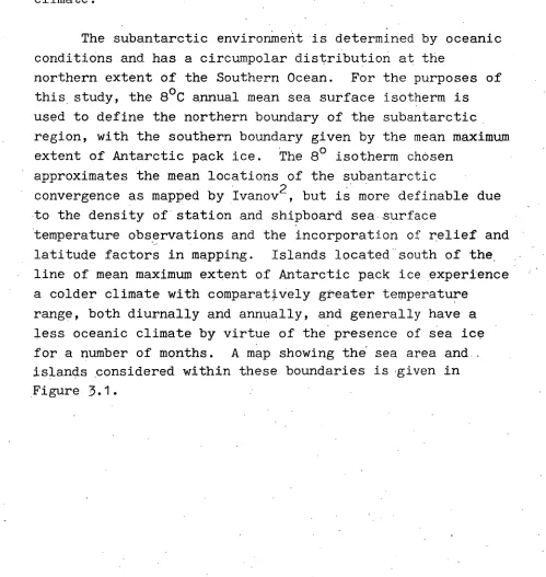
The subantarctic environment is determined by oceanic conditions and has a circumpolar distribution at the
northern extent of the Southern Ocean. For the purposes of this study, the 8°C annual mean sea surface isotherm is used to define the northern boundary of the subantarctic region, with the southern boundary given by the mean maximum extent of Antarctic pack ice. The 80 isotherm chosen
approximates the mean locations of the subantarctic
convergence as mapped by Ivanov2, but is more definable due to the density of station and shipboard sea surface
temperature observations and the incorporation of relief and latitude factors in mapping. Islands located south of the • line of mean maximum extent of Antarctic pack ice experience
a colder climate with comparatively greater temperature range, both diurnally and annually, and generally have a less oceanic climate by virtue of the presence of sea ice for a number of months. A map showing the sea area and. islands considered within these boundaries is 'given in
[image:33.566.41.540.296.823.2]V NEW
Z? ZEALAND SOUTH
leo- . I ... PACIFIC
• 1 OCEAN
• :50'
a AUCKLAND I.
ti
CAMPSELL I.,MACQUARIE I./
/ / •
/
/ 7r—
AUSTRALIA
8•C ANNUAL MEAN SEA
SURFACE ISOTHERM
ANTARCTICA
HEARD, I. / 't1eD13NA).. / DIs:X
ILES KERGUELEN
7
LES CROZET
. MARION
'
PRINCE EDWARD Ii
/ / FALKLAND Is. -SOUTH ORKNEY M.'
/ / SOUTH GEORGIA Is.
••• SOUTH 7 /
SANDWICH Is. ,
SOUTH SHETLAND Is.
INDIAN OCEAN
SOUTH ATLANTIC
OCEAN
TRISTAN DA CUNHA Is. .
SOUTH AFRICA
[image:34.560.51.534.34.692.2]- 28 -
From Figure 3.1, it can be seen that, within the subantarctic region, only a handful of islands occur. The islands are all remotely located but share distinctive climatic and biological features. They •
all experience an oceanic climate characterised by
extreme constancy of temperature at sea level and westerly atmospheric circulation with high relative humidity.
Biologically, the vegetation cover is largely restricted to non-woody vascular species. The combined area
of the islands is relatively small,but they represent significant ice-free land exposures and are a critical foothold for the biological life typical of the region.
3.2 Climate
Aspects of atmospheric circulation and climate of the Southern Ocean have been covered by several workers 3 with particular reference being paid to the contribution of Southern Ocean conditions to the weather experienced in Australia! In In general, most meteorological studies of the Southern Ocean and, therefore, the subantarctic, have been of a synoptic nature directed towards weather forecasting elsewhere.
Comparative analyses of Meteorological observations from subantarctic islands and from information collected by ships in the region have rarely been attempted. The sole comparative analyses of surface weather observations from a spread of subantarctic islands, roughly equi-distant
around Antarctica, was completed by Fabricus 5 nearly thirty years ago. A similar study for the Falkland Islands and Dependencies was made around the same time by Pepper6. The
•The subantarctic region experiences westerly atmospheric circulation. From wind roses compiled by Fabricus7 and Pepper8, on average, winds with a westerly component account for 'M of the winds with a westerly
the islands studied. A summary of frequency of wind speeds
by Fabricus9 shows that wind velocities between 16 and 30 km/hour are dominant in the region with velocities between 31 and 62
km/hour slightly less frequent. All islands experience blustery conditions and can be expected to encounter 130 km/hour gusts for periods longer than a day at least once a year.
The northward migration of westerly circulation from the high southern latitudes is constrained by low pressure features, generally, of continental origin, which extend
south-eastward from South Africa, Australia and South America. 10 Within the subantarctic region, the flow of westerly air
is interrupted by cyclonic activity and high pressure ridges which cause considerable cloud over the region.
Precipitation is largely latitude dependent and increases with lower latitudes, but is greatly influenced by island topography. The influence of island topography is worth noting. Because atmospheric temperatures at sea level are close to zero throughout the year, temperature decrease with elevation of the island topography has a pronounced effect on the overall climate of islands, particularly in combination with orographically derived
precipitation usually falling as snow or rime. Precipitation usually occurs at the fronts of depressions which move from west to east at frequent intervals. It is not atypical for precipitation in the form of rain or snow to occur daily at subantarctic islands.
As previously mentioned, a climatic characteristic of the subantarctic region is the extreme constancy of
- 30 -
in the region is in the order of 6 ° C. The annual temperature pattern is sinusoidal with the mean maximum temperature and mean minimum temperatures occurring in February and
September respectively.
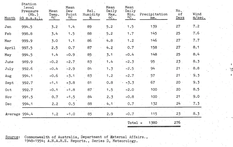
The climate of Heard Island has been studied by Gibbs and co-workers who analysed meteorological data 11 collected in 1948, and by glaciologists12 using data collected during the. period 1948-1954 for surveys of the mass balance of glaciers on the island. Meteorological data for Heard Island were obtained continuously from 1948 to
1954 by ANAREs. Average monthly records for this period are given in Table 3.1: Meteorological
observations have not been made on the McDonald' Islands.
Ambient temperatures at sea level on Heard Island show little seasonal variation with average winter temperatures . around 5 ° C' colder than in summer. Average . monthly temperatures at sea level are close to freezing. From the data collected, the mean maximum temperature is 3.2 ° C occurring in February with the mean minimum temperature. of -. 0.6 ° C occurring in
August, a:month earlier than most other subantarbtiC'islands which generally have a more . northern distribution. The time of mean minimum temperature correlates with the northernmost'extent of
the , .Antarctic sea-ice cover, a characteristic observed on the other subantarctic islands studied by Fabricus and Pepper.. '
Precipitation on Heard Island is relatively constant throughout the year with a slight decrease in winter. ' Average monthly precipitation ranges from 94 mm in July to
158 mm in April, giving a total annual precipitation of
1380 mm. The atmosphere is near saturated throughout the year with a slight' decrease in relative humidity (1%) during the 'winter.
The effect of local topography on precipitation and the flow of air has a marked' effect on the local climate .
Station level Pressure
(Mb.)
Mean Temp.
No.
of Wind
Mean Dew Point
Rel. Humidity
Mean Daily
Max.
Mean Daily
Min. Precipitation
Month 49 m.a.s.l. °C oc % 0C. oc. mm. 22YR 1 LatIL
Jan 994.5 3.2 1.4, 89 5.2 1.5 139 27 7.2
Feb 998.8 3.4 1.5 88 5.2 1.7 145 25 7.6
Mar 999.9 3.0 1.1 86 4.8 1.2 146 27 7.7
April 997.5 2.5 0.7 87 4.2 0.7 158 27 8.1
May 994.5 1.4 -0.9 85 3.1 -0.4 148 25 8.4
June 989.9 -0.2 -2.7 83 1.4 -2.3 95 . 23 8.3
July 992.6 -0.4 -2.9 84 1.3 -2.5 94 21 8.8
Aug 994.1 -0.6 -3.1 83 1.2 -2.7 57 21 ' 9.3
Sept 992.7 -1.1 -3.8 81 0.8 -3.3 67 20 9.3
Oct 992.7 -0.1 -1.8 87 1.5 -2.0 100 20 8.5
Nov 991.5 0.7 -1.5 . 84 2.3 -0.8 100 _ 21 9.0
Dec 994.1 2.2 0.5 88 4.1 0.7 132 24 7.3
Average 994.4 1.2 -1.0 85 2.9 -0.7 115 23 8.3
Total = 1380 276
[image:38.831.25.820.42.545.2]- 32-
forces the uplift of moist air and consequent orographically derived precipitation in the form of snow or rime. There are no direct measurements on Heard Island of temperature and precipitation with elevation above sea level, but the relationship between variables has been estimated by
13 Allison .
In winter, it is expected that the average
rate of temperature decrease with elevation above sea level is 0.7 D C/100 m in the first 1000 m, decreasing to 0.5 ) C/100 m at the summit of the main, volcanic cone of Big Ben. Mean
temperature at the summit is estimated to be around -16 ° C in winter and -10 ° C in summer. Average annual snowfall at the summit is estimated to amount to in excess
•of 4 m of water/year. Due to the presence of permanent ice cover on Heard Island and the channeling of onshore wind by steeply-rising topography, microclimatic differences between HI&McDIs are expected to occur.
The location of HI&McDIs in the stream of westerly air flow is indicated by the constant average wind
speed recorded. Average monthly wind speeds range from 7.2 m/sec in January to 9.3 m/sec in August and September. Similar wind conditions are observed at Iles Kerguelen approximately 240 nautical miles NW from Heard Island. Hence, although the McDonald Islands may vary in microclimate, their major weather features are likely to be identical with those on Heard Island.
3.3 Geology and Landforms
As discussed in Section 2.2, HI&McDIs are located on the Kerguelen Plateau, an isolated
sea floor feature which rises some 3 700 m above the adjacent deep sea floor and along its NW-SE trending axis, exceeding 2 000 km in length. The plateau's morphology has been
investigated by Watkins14 , Houtz and others 15 , and Brock16 , who suggested that the feature is unlikely to be of
'ocean floor that existed west of Australia before Australia separated from Antarctica.
' Uplifted limestones are the, oldest geological sequence found on Heard Island and contain foraminifera.indicating marine origins in the lower tertiary period17. Limestone outcrops are visible only at a few locations on the Island, being overlain by glacial sediments and interbedded volcanic lavas which may be as much as 250 - m thick18 .
Volcanism has been an important geological occurrence. The dominant geological feature of Heard Island is the conic .structure of the subdued volcano, Big Ben. At sea level,
the base of Big Ben averages 20 km in diameter and rises to 2745 m. Laurens Peninsula, which ,is separated from Big Ben by a narrow isthmus, is also volcanic in origin with its
highest feature, Anzac Peak, rising to 715 m above sea level. On Big Ben and Laurens Peninsula and at several . points around the coast there are a number of remnant, major cones and
subsidiary vents with present-day volcanic activity visible intermittently at the summit of Big Ben. ' The Island is, therefore, the only active volcano in Australian Territory..
Heard Island is all but covered by permanent snow and ice and extensive glaciation occurs. Glacial activity has been studied by Budd and Stephenson19, and Budd and Allison20, but systematic study of the Island's glaciers has not been conducted. Because of the proximity of Heard Island to the Antarctic convergence, glaciers have been considered inherent indicators of climatic change in the Southern Ocean region, and investigations have focused on mass balance studies of ,a number of glaciers.
- 34 -
sea level. Ice velocities in the order of 250 m per year have been estimated by Budd and Allison 21 for the '
equilibrium line of the Vahsel Glacier.
Glacial action has resulted in extensive erosion and reworking of volcanic material and glacial sediments. In addition, marine processes have been active in the
formation of the isthmus linking Laurens Peninsula with the main part of the Island and in the building of the narrow spit extending seaward from the south-eastern end of the Island. Where glacial activity does not extend to the sea, grey volcanic sand beaches have been formed.
Together, climate and the nature of parent material prevent appreciable development of soil on
HI&McDIs. Bacterial action in the soil is so slow •that little humus is formed and vegetative cover is
restricted to communities of either azorella and- poa grass or. moss and,lichen communities.
3.4 Biology
The islands which occur in the subantarctic region are isolated land masses which are located at intervals about the Southern Ocean and maintain a distinctive flora and fauna.. Marine mammals and seabirds, many of which are migratory with feeding ranges in the Antarctic and subantarctic, are attracted to the islands in summer to breed and form the principle fauna of the islands. Non-w6ody vascular plant species are the common flora of
the region which has been described by several workers as impoverished and disharmonib, reflecting the recent volcanic origin of most islands, present and past
colonisation by other plant and animal species. The
characteristic features of the subantarctic ecosystem are summarised by Holdgate and Wace 22 , and are given below:
(a) Poverty in numbers of native species. The extreme
remoteness of the islands and the recent occurrence of glacial and periglacial conditions on present-day . ice-free land outcrops has restricted.the numbers of
species capable of colonising the islands. • (b) The absence of important animal and plant groups.
Difficulties of long-range dispersal across the oceans has prevented important animal and plant species from
colonising the islands, and many common species found elsewhere are not represented. The absence of certain predators has favoured particular species; for example, the absence of cats, rats and mice has permitted the development of ground-nesting and flightless birds found in these latitudes.
(.c) Modified ecological behaviour of species. In the
absence of predators, species have evolved distinctive behavioural patterns, and some species fill niches from which they would normally have been excluded.
(d) Evolution of endemic species. The geographic remoteness of the islands has prevented interbreeding with
continental parent stocks resulting in divergent evolution in sympathy with the island environment. Endemism may also exist because of the absence of predator species; this allows species' continuation when continental counterparts have been eliminated.
Consequently, the subantarctic islands maintain simple
ecosystems which have proved sensitive to pressures placed on them by humans. The vulnerability of island wildlife and habitats is a product of three inter-related factors. Firstly,
-36
unsuccessful in competition with introduced species. Secondly, island ecosystems have few interacting species and alteration of any one element has escalating effects on the whole ecosystem. .Finally, island species are not adapted to conditions produced by humans and introduced species readily replace indigenous populations.
Commencing in the late 1700s, and before the development of scientific interest insubantarctic islands, island biotas were gradually modified through the activities of sealing gangs
and shore-based whaling communities. In their natural'state, the islands could not maintain a supply of fresh meat for
the settlers and a variety of grazing animals were deliberately introduced for this purpose. Cats, rats and mice were also spread to most islands. The island biotas which had evolved in the absence of human introduced predators, floras, faunas and parasites were, consequently, affected while seal and penguin populations were indiscriminately slaughtered and exterminated on some islands. The permanent modification of island ecosystems was all but complete except for
HI&McDIs which, despite extensive
sealing on Heard Island in the period 1857-1929, remain today as the only landmasses in the subantarctic region without human introduced animal and plant species.
As the only unModified islands in the subantarctic region, HI&McDIs are of unique scientific value. Knowledge of their biology comes from research carried out by
This Section summarises information gathered by expeditions on the flora and fauna of the Islands. Comparisons with the biology of other subantarctic
islands are also made to illustrate the uniqueness of the islands under study and their vulnerability to alien species.
3.4.1 Flora
Checklists of alien plant and animal species occurring on subantarctic islands are given by Holdgate and Wace23 and by Greene and Walton respectively. Both studies 24
conclude that, for the majority of the islands, the effects of species introduction on the environment are irreversible and that island floras and faunas are more vulnerable to human interference than continental regions with comparable climate and terrain.
The first scientifib description of the vegetation on.• Heard Island was made by Moseley25, a naturalist on the
"Challenger" expedition which landed at Heard Island for a matter of hours in February 1874. To Moseley, the Island was a barren outcrop and "miserably poor in flora, even for the higher latitudes of the southern hemisphere".
The vegetation on the Islands wassimilar to that
found on Iles Kerguelen, Marion and Prince Edward Islands which
the expedition had previously visited. The same islands were subsequently grouped by Greene and Greene 26 in their identification of the subantarctic botanical zone, a
classification which has won wide acceptance.
The vegetation on Heard Island and, to a lesser extent, the McDonald Islands has been studied by ANAREs from 1947, with
- 38-
The dominant vegetation on the Islands is herbaceous with tussock grasses, Azorella, Acaena and Kerguelen
cabbage, Pringlea antiscorbutica, providing most ground cover. A total of eight vascular species are known to occur on
Heard Island and five on the McDonald Islands. Five vegetation cover types have been described by Jenkin 27. These are: the poa complex found on relatively well-drained hill slopes, grasslands, meadow, herb and fell-
. field. Plant species are typically subantarctic in
distribution and have proven favourable for the introduction of reindeer, rabbits, sheep, and goats onto other
islands. A list of flowering plants, mosses and lichens so far recorded on HI&McDIs is given in Table 3.2.
An investigation of subantarctic plant ecology has 28
been completed by Jenkin for Macquarie Island which hosts several plants recorded on HI&McDIs. The
plants have a high annual production
and efficiently utilise low levels of radiation and low • temperatures. Seasonal variation in plant biomass is
attributed to variation in radiation. The vegetation is also extremely well salt-adapted and is able to tolerate salt- , .laden winds without evidence of transpiration stress.
However, in comparison with Macquarie Island and Iles Kerguelen; very few vascular species occur on Heard Island. It has also been.
observed that, for some species. .(such as Kerguelen cablzege), plant size at maturity i8,smaller than at other subantarctic islands, but there have been no studies to measure plant size and variations in growth rates on an inter-island basis. These anomalies may be in part explained by the colder climate, the physical nature of exposed land and the quality of soil available for plant colonisation on Heard Island.
3.4.2. Fauna •
Whereas the botanical species on HI&McbIs are few and have remained relatively undisturbed since the
1. HERBS AND GRASSES 2. MOSSES
Andreaea sp.
Amblystegium serpens B. et S.
Bartramia papillata H.f. et W.
Bartramia diminutiva Broth.
Bartramia robusta H.f. et W.
Blindia robusta Nampa
Blindia contecta (Schwaeg.) Par.
Brachythecium salebrosum (Web. et Mohr) B. S. G.
Ceratodon purpureus (Hedw.) Brid.
Dicranoloma billardieri (Schwaeg.) Par.
Dicranoweisia qrimmiacea (C.M.) Broth.
Ditrichum immersum van Zanteu
Ditrichum subaustrale Broth.
Drepanocladus uncinatus (Hedw.) Warnst.
Grimmia immerso-leucophaea (C.M.) Kindb.
Muelleriella crassifolia (H.f. et W.) Dus.
Pogonatum alpinum (Hedw.) MiH.
Rhacomitrium crispulum (H.f. et W.) H.f. et W.
Rhacomitrium lanuqinosum (Hedw.)
Brid. var. prOinosum H.f. et W.
Schistidium apocarpum (Hedw.) B. et
S. in B. S. G.
Tortula rubra Mitt.
Verrucidens tortifolius (H.f. et W.)
Reim. Azorella selago Hook f.
Poa cookii Hook f.-
Colobanthus kerquelensis Hook f.
Festuca kerguelensis Hook f.
Callitriche antarctica Engelm ex Hegelm
Acaena magellanica (Lam.) Vahl.
Pringlea antiscorbutica R. Br, ex Hook f.
[image:46.565.22.542.25.819.2]There is no comprehensive work dealing with the botany of the subantarctic islands.
TABLE 3.2 Vegetation Recorded for Heard Island
and the McDonald Islands
SOURCES:
CLIFFORD, H.T., 1953; The Mosses of Macquarie Island and Heard Island,
A.N.A.R.1. Reports, Series B.II, Botany, 1-12; Government Printer, Melbourne.