An ASABE – CSBE/ASABE Joint Meeting Presentation
Paper Number: 141898868
Q
UANTIFYING THE IMPACTS OF COAL SEAM GAS
(CSG)
ACTIVITIES ON THE SOIL RESOURCE OF AGRICULTURAL LANDS
IN
Q
UEENSLAND
,
A
USTRALIA
C. A. Vacher, S. White, J. Eberhard, E. Schmidt, N. I. Huth, D. L. Antille
The authors are C. A. Vacher, PhD Student, S. White, Research Fellow, J. Eberhard, Research Fellow, E. Schmidt, Deputy Director, D. L. Antille, ASABE Member,Research Fellow, National Centre for Engineering in Agriculture, University of Southern Queensland, Toowoomba, Queensland, Australia and N. I. Huth, Research
Scientist, Commonwealth Scientific and Industrial Research Organisation, Toowoomba, Queensland Corresponding author: Cameron Vacher, University of Southern Queensland, National Centre for Engineering in Agriculture, West Street, Toowoomba Qld 4350, Australia; phone: +61 408 753 158; e-mail:
d9511527@umail.usq.edu.au.
Written for presentation at the
2014 ASABE and CSBE/SCGAB Annual International Meeting
Sponsored by ASABE
Montreal, Quebec Canada
July 13 – 16, 2014
Abstract. Coal seam gas (CSG) activities in the Surat and Bowen Basin areas of Queensland, Australia, cover
approximately 300,000 km2 including regions of good quality agricultural lands. Without adequate knowledge of soil properties, hydrologic processes and control measures, the disturbed soil structure and landform in these regions are highly susceptible to soil degradation. The construction and installation of CSG infrastructures (e.g. roads, pipelines, hardstand and plant areas) cause various degrees of disturbance to the soil physical, chemical and biological characteristics. This disturbance may result in soil degradation through various forms including compaction, erosion processes, changes to organic carbon and soil nutrient store, exposure of potentially reactive/poor quality soils (e.g. acid sulphate soils, hyper-saline soils) or introduction of outside contaminants (poor quality water, weeds). Not only are soils directly disturbed by the footprint of the CSG operation but the surrounding soil landscape may be disturbed by secondary processes such as erosion and sedimentation. Soil compaction changes caused by CSG operations, including vehicle impacts and trench line installation, have been assessed by soil bulk density measurements. This measurement has been identified as a common impact by CSG operation and a key element of soil degradation of agricultural areas contributing poor vegetation establishment, tunnel and surface erosion processes and an ongoing decline for soil productivity. Quantifying the impacts of CSG activities on soils will inform the development of industry guidelines for impact minimisation and management of the soil resource on joint CSG-agricultural lands.
Introduction
Soil security and food supply are critical pressing issues facing the world today. With food demand expected to double by the middle of the century, the Earth’s productive capacity is being impacted by many factors such as climate change, increasing scarcity of water and loss of farmland (McBratney et al, 2014, Bolton and Crute, 2011). Recently in Queensland, concerns have been raised that coal seam gas (CSG) activities could impact agricultural productivity and hence food production through threats to surface and groundwater resources, loss of agricultural land to infrastructure developments and adverse impacts on the agricultural soil resource. The existing policy for protecting Queensland’s strategic cropping land (SCL) states that development on such lands that temporarily diminishes productivity of the land will, at the end of the development, restore the land to strategic cropping land condition (DERM, 2010). A balanced co-existence of mining and agriculture is suggested as possible, but requires careful management.
The footprint of CSG development on agricultural lands and the environment is acknowledged as much greater than the proportionally small area devoted to the well-head infrastructure, or even surrounding lease area during development. Access roads and the installation of pipeline (gathering) networks, as well as laydown yards and vehicle mustering points outside the lease area represent additional areas of potential significant impact to agricultural lands. The extent and nature of damage to the soil resource caused by the various elements involved in the development of the CSG industry are currently not well documented. Furthermore, methods for avoiding, managing or remediating these differing impacts are not understood, and although existing methods for land reclamation and restoration exist, they application, suitability and success in the context of the CSG industry have yet to be quantitatively assessed.
REGIONAL DESCRIPTION
The majority of current and planned future developments in the CSG industry in Eastern Australia are concentrated within the Surat and Bowen Basins, Queenland. The Surat Basin occupies approximately 300,000 km2 of Central Southern Queensland and Central Northern NSW and the Bowen Basin covers an area of approximately 60,000 km2 of Central Queensland (Geoscience-Australia, 2008).
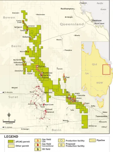
Figure 2. Gas fields tenements and facilities of Australia Pacific LNG (APLNG - Origin Energy/Conocco Phillips) within the Surat and southern Bowen Basins (Source APLNG).
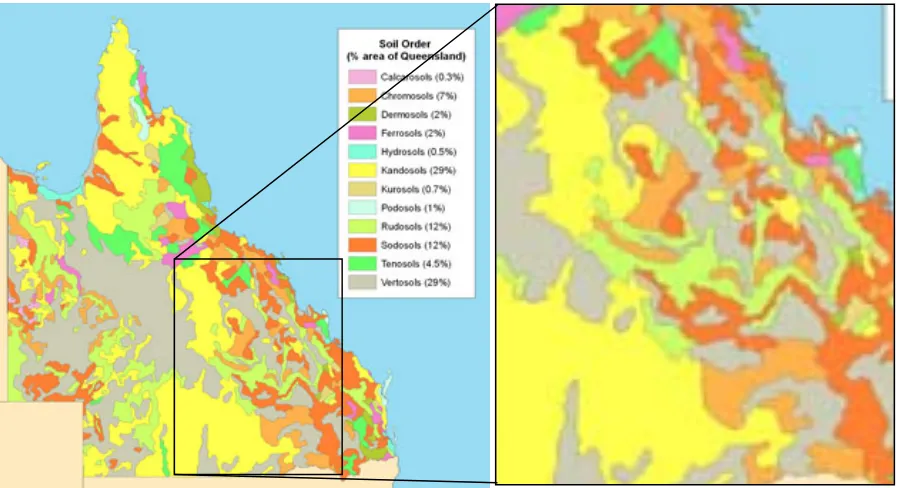
Figure 3. Dominant soil types within the Surat and Bowen Basins (Queensland, http://www.nrm.qld.gov.au/science/slr/queensland_soils.html).
Table 1. Major soil types within the Surat and Bowen Basins (MacKenzie, 2004).
Australian Soil Classification Occurrence in Queensland (%)
Description Erosion Risk
Vertosol 29 Commonly known as Black, Grey or Brown Earths and Black, Grey or Brown Cracking Clays. Characterised by high clay contents (>35% clay) with shrink-swell properties which cause deep and wide cracking on drying. The most
common soil type in Queensland (particularly in the Surat and Bowen Basins), with high value for agricultural productivity due to their high water
holding capacity.
Typically low due to low natural gradients and high potential for
grass cover establishment. Kandosol 29 Characterised by a typically deep profile (up to 3m) and a lack of a clear
texture change from the A to B horizons. Clay content may increase gradually to 35-50% to a depth of 1m. It is the second most common soil type in Queensland although mainly located in the centre and north of the state. Generally has a low to moderate agricultural potential due to moderate
fertility and water holding capacity (cropping is usually limited by local deep drainage potential characteristics).
Susceptible to surface erosion processes particularly following clearing/disturbance.
Sodosol 12 Characterised by a clear texture contrast and permeability drop between the A and B horizons with an elevated concentration of sodium (and dispersion) in the B horizon. Generally has a low nutrient status and very susceptible to land degradation (erosion and dryland salinity) if vegetation is removed. Land-uses include grazing of native or improved pastures for both dryland
and irrigated agriculture, and forestry.
Highly susceptible to surface seal formation,
surface erosion and tunnel erosion
processes. Rudosol 12 Characterised by little or no pedological development and relatively low
fertility and water holding capacity. Usually supports grazing of native pastures. Occasional fertile variants formed in alluvium are used for cropping
and improved pastures. Typically occurs in arid regions of central and northwest Australia (minor in the Surat and Bowen Basins).
Moderate susceptibility to surface erosion.
Chromosol 7 Characterised by a strong texture contrast between the A and B horizons although distinguished from other texture contrast soils, such as Sodosols,
by not being sodic (non-dispersive) in their upper B horizons. These soils may have favourable physical and chemical properties for grazing of native pastures. However, most occurrences in Australia have hardsetting surface layers and impeded internal drainage caused by structural degradation from
long-term agricultural practices.
Moderate susceptibility to surface erosion due to long term degradation
[image:5.612.55.562.344.668.2]processes that compound the impact and lead to land sustainability and degradation concerns. Most notable amongst these secondary impacts are changes in surface and subsurface hydrology and elevated erosion risk.
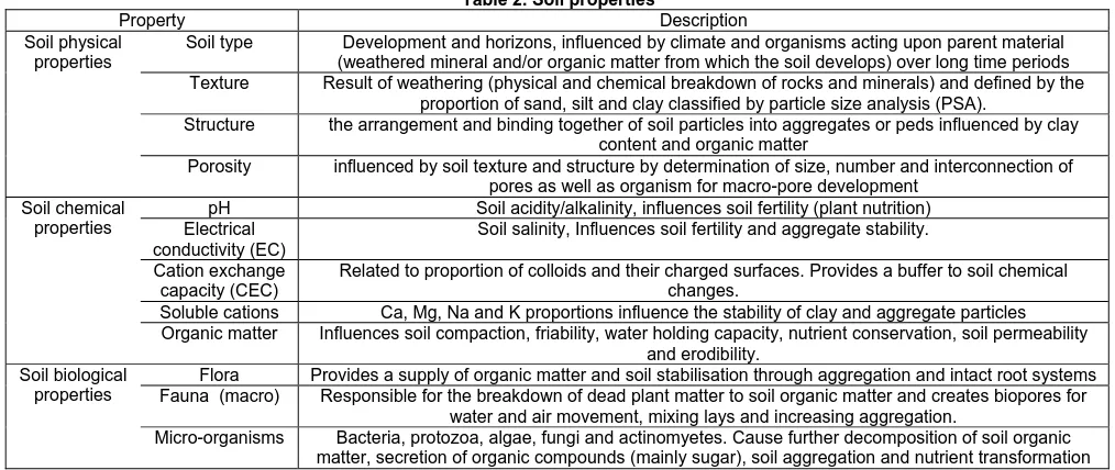
[image:6.612.52.559.197.411.2]Soil “quality” in terms of physical, chemical and biological characteristics (Table 2) can be characterised by both its’ pedagogical and dynamic processes (Carter, 1998). The pedagogical processes relate to the soils parent material (mineralogy and particle size) and are relatively static over time. The quality of a given soils static processes is a function of other factor such as climate, topography and hydrological parameters. Dynamic processes of the soil relate to those which can change over time (i.e. structure, porosity and organic matter) and change due to environmental impacts, human disturbances and land management practices. Soil health in terms of agricultural is dependent on the maintenance of four major functions (carbon transformation, nutrient cycles, soil structure maintenance, and the regulation of pests and diseases) which function based on a variety of biological processes driven by interacting soil organisms under the influence of the abiotic soil environment (Kibblewhite et al., 2008).
Table 2. Soil properties
Property Description Soil physical
properties
Soil type Development and horizons, influenced by climate and organisms acting upon parent material (weathered mineral and/or organic matter from which the soil develops) over long time periods Texture Result of weathering (physical and chemical breakdown of rocks and minerals) and defined by the
proportion of sand, silt and clay classified by particle size analysis (PSA).
Structure the arrangement and binding together of soil particles into aggregates or peds influenced by clay content and organic matter
Porosity influenced by soil texture and structure by determination of size, number and interconnection of pores as well as organism for macro-pore development
Soil chemical properties
pH Soil acidity/alkalinity, influences soil fertility (plant nutrition) Electrical
conductivity (EC)
Soil salinity, Influences soil fertility and aggregate stability. Cation exchange
capacity (CEC)
Related to proportion of colloids and their charged surfaces. Provides a buffer to soil chemical changes.
Soluble cations Ca, Mg, Na and K proportions influence the stability of clay and aggregate particles Organic matter Influences soil compaction, friability, water holding capacity, nutrient conservation, soil permeability
and erodibility. Soil biological
properties
Flora Provides a supply of organic matter and soil stabilisation through aggregation and intact root systems Fauna (macro) Responsible for the breakdown of dead plant matter to soil organic matter and creates biopores for
water and air movement, mixing lays and increasing aggregation.
Micro-organisms Bacteria, protozoa, algae, fungi and actinomyetes. Cause further decomposition of soil organic matter, secretion of organic compounds (mainly sugar), soil aggregation and nutrient transformation
Impacts of the CSG Industry on the Soil Resource.
The most common range of direct impacts on the soil resource can be broadly defined under the following: (1) soil surface disturbance, (2) soil compaction, and (3) soil layer inversion. These result in changes in the soil physical, chemical and biological characteristics.
Surface Disturbance
Surface disturbance from the removal of vegetative cover can result in a loss of soil flora and soil organic matter cycling. The loss of vegetative cover also has direct impacts on soil surface resisitance to erosion processes (raindrop impact and runoff).
Compaction
Compaction is a form of physical degradation to soil structure resulting from loads applied which push soil particles together causing deformation of soil aggregates. Traffic from machinery and livestock trampling can be major cause of compaction. The rearrangement of the soil aggregates and/or soil particles from compaction reduces the voids and/or pores between them resulting in higher bulk densities and soil strength, reduced soil porosity, water infiltration, water holding capacity and exchange of gases. This additionally impacts the chemical and biological characteristics of the soil making it less favourable for beneficial soil fauna (i.e. earthworms, termites, microorganisms) and biological activity (e.g. increased saturated conditions and reduced gas exchange causing denitrification (Duiker, 2004, Hamza and Anderson, 2005, Alaoui et al., 2011, Six et al., 2004).
Soil Mixing and Layer Inversion
chemical characteristics are less desirable than the existing surface soil conditions and react adversely to exposure to the elements. This is characteristic of Sodosols, Chromosols and some Vartosols which are all common in the Queensland gas field. A potential result for Sodosols in particular (or Vertosols with sodic subsoil) is placement of highly sodic soil towards the surface that is prone to dispersion, surface crusting and erosion (Hardie et al, 2007, Vacher et al, 2004).
Soil impacts from CSG Infrastructure
The type and degree of impact on the soil resource from CSG development is dependent on a host of factors including; foot print of disturbance area, installation equipment and procedures used, size and number of infrastructure elements (pipelines, well pads, processing plants) required, access track requirement and traffic frequency. The natural environment (particularly weather during operations), access to public roads, and proximity to natural resources (fauna, flora) and eco-systems like waterways may influence management practices that can also modify the impact of development activities.
[image:7.612.77.538.325.681.2]However, to aid in the understanding of likely impacts from CSG development the various major elements of exploration, development, gas production and final decommissioning are summarised in Table 3. In addition to the aforementioned variables influencing the degree of impact in any area there is also high variability due to different CSG companies and individual contractors engaged preferred processes and practices. Due to this, the dimensions and quantity within most zones of impact are highly variable.
Table 3. CSG infrastructure zones and impacts (figures from Qld DNRM and various CSG company information sheets)
CSG zone Dimensions Quantity Impacts Pipeline right
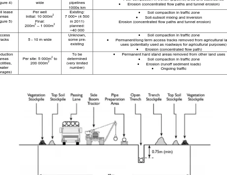
of way (ROW) (Figure 4)
Construction: typically 15 to 25m
wide To be determined, existing pipelines 1000s km
Soil compaction in traffic zone
Soil-subsoil mixing and inversion
Poor compaction in trench (pipeline) area and subsidence
Erosion (concentrated flow paths and tunnel erosion)
Well lease areas (Figure 5)
Per well Initial: 10 000m2
Final: 200m2 – 1 000m2
Existing: 7 000+ (4 500
in 2011) planned:
~40 000
Soil compaction in traffic zone
Soil-subsoil mixing and inversion Erosion (concentrated flow paths and tunnel erosion)
Access
tracks 5 - 10 m wide
Unknown, some
pre-existing
Soil compaction in traffic zone
Permanent/long term access tracks removed from agricultural land uses (potentially used as roadways for agricultural purposes)
Erosion (concentrated flow path) Production
areas (facilities,
water storages)
Per site: 5 000m2 to 200 000m2
To be determined (very limited
number)
Permanent hard stand areas removed from other land uses
Soil compaction in traffic zone
Erosion (runoff sediment loads)
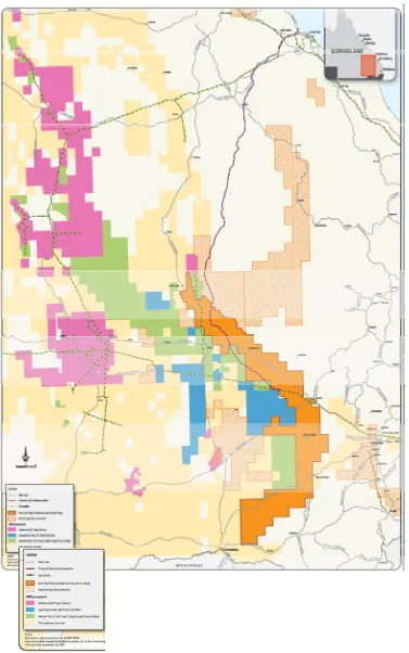
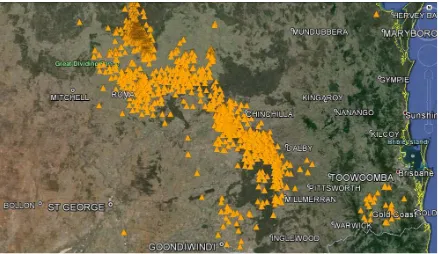
[image:7.612.116.503.517.689.2]Figure 5. Existing coal seam gas well locations in the Surat Basin (Southern Queensland, http://www.nrm.qld.gov.au/science/slr/queensland_soils.html)
Pipeline installation and operation includes extensive distances to connect wells to processing plants, services delivery (primarily water) and large pipelines to deliver process CSG to export facilities. In the context of quantifying the impact to agricultural areas from pipelines installed to transport water and gas to/from individual wellheads and facilities, the area is classified as the construction right of way (ROW) (Figures 4 and 6). Impacts to the soil resource include surface disturbance due to cut and grading, removal of surface cover and soil layer mixing or inversion during backfilling. Secondary impacts commonly resulting from this disturbance includes infiltration and drainage impedance (or high variability), subsidence, surface and tunnel erosion particularly for Sodosol and Chromosol soil types.
Figure 6: CSG gathering line right of way demonstrating limited vegetation establishment and subsidence.
[image:8.612.99.514.442.624.2]decommission wellhead may also occur.
Figure 7. Fenced off operational CSG well pad (~12 x 8 m, initial construction area outside fenced area) (Arrow, 2012)
Access tracks specifically refers to temporary roads used between the various lease areas and existing landholder or public roads. Their use is predominately during the exploration and development phases where heavy and frequent traffic is experienced but may be extended to maintenance tracks for the production life of respective wells. Impacts to this area are caused by roadway construction which can involve removal of soil surface, cutting and grading, and consolidation of road base material to support vehicle traffic to allow all weather access. The degree of impact across the wide range of access tracks depends not only on the construction method, but also the intensity of the traffic, and soil type and conditions during construction and use. Duiker (2004) found that based on more than 20 soil compaction experiments in North America and Europe compaction in the topsoil is related to ground contact pressure only, compaction in the upper part of the subsoil is related to both ground contact pressure and axle load, and compaction in the lower subsoil is related to axle load only. Farmers in America and Canada have noted soil compaction in their fields from repeated truck and equipment traffic along access roads and pipelines due to gas industry development (Kubach et al., 2011). As most drilling rigs and trucks used in the CG industry are heavier than normal farm machinery, the risk (and variability) in surface and persistence in subsoil compaction is considered to be high.
Summary
Evidence pertaining to overseas experience has noted that well pad development is a far lesser landscape disruption than the extensive network of associated pipelines from gas development (Drohan and Brittingham, 2012). Current measurements from Queensland CSG areas indicates a similar situation with the spectrum of impacts occurring on the soil resource due to pipeline installation including textural, structural and chemical degradation resulting in areas of highly impact surface and subsurface hydrology and higher erosion potential.
Although industry and pipeline manufacturing guidelines exist on best practice for effective pipeline installation, soil management and re-compaction during back fillingAustralian Pipeline Industry Association (APIA) code of practice (APIA, 2013), there are common cases of pipeline subsidence, surface and tunnel erosion occurring across the Surat and Bowen Basin. In addition to this, the concentration of runoff in this depression along pipeline trench, generates the potential of additional runoff volumes from the interruption of the natural flow of surface water from upslope catchment areas that can add significant volumes to the concentrated flow and erosion potential relative to the upslope catchment area (Olson and Doherty, 2012).
Further research within this field is to further quantify the soil impacts by CSG activities to;
Quantify the extent of impact within specific soil types,
Undertake laboratory measurements to assess the severity of impacts based on interrelations between practices, soil type and topography, and
Acknowledgements
The authors wish to acknowledge the support and information supplied to this research work through the Gas Industry Social and Environmental Research Alliance (GISERA), a bi-lateral agreement with founding members CSIRO and Australian Pacific LNG.
References
ACLUMP. 2010. The Australian land use and management (ALUM) classification Version 7 [Online]. Australian Collaborative Land Use and Management Program, Department of agriculture, Fihseries and Forestry. Available: http://adl.brs.gov.au/landuse/docs/ALUM_Classification_V7_May_2010_detailed.pdf 2013].
Alaoui, A. Lipiec, J. & Gerke, H.H. (2011). A review of the changes in the soil pore system due to soil deformation: A hydrodynamic perspective. Soil and Tillage Research, 115–116, 1-15.
APIA (2013). Upstream PE gathering Networks- CSG Industry APIA Code of Practice. Kingston, ACT: APIA.
Bolton, S.M. & Crute, I.R. (2011) Crop nutrition and sustainable intensification. Proc. No.: 695, 2011 York, UK. The International Fertiliser Society,.
Carter, M.R. (1998). Organic matter and sustainability. In: REES, R. M. (ed.) Sustainable management of soil organic matter. Wallingford, UK: CAB international.
Drohan, P.J. & Brittingham, M. (2012). Topographic and Soil Constraints to Shale-Gas Development in the Northcentral Appalachians. Soil Sci. Soc. Am. J., 76, 1696-1706.
Duiker, S.W. (2004). Avoiding Soil Compaction. Penn State Extension, College of Agriculural Sciences, Agricultural Research and Cooperative Extension.
Duiker, S.W. & Micsky, G.W. (2009). Avoiding and Mitigating Soil Compaction Associated with Natural Gas Development.: Penn State Extension, College of Agriculural Sciences, Marcellus Education Team.
Geoscience-Australia. (2008). Surat Basin[Online]. Available: http://www.ga.gov.au/oceans/ea_Surat.jsp 2012].
Hamza, M.A. & Anderson, W.K. (2005). Soil compaction in cropping systems: A review of the nature, causes and possible solutions. Soil and Tillage Research, 82, 121-145.
Hardie, M.A., Cotching, W.E. & Zund, P.R. (2007). Rehabilitation of field tunnel erosion using techniques developed for construction with dispersive soils. Soil Research, 45, 280-287.
Isbell, R.F. (2002). The Australian Soil Classification, Melbourne, CSIRO Publishing.
Kibblewhite, M.G., Ritz, K. & Swift, M.J. (2008). Soil health in agricultural systems. Philosophical Transactions of the Royal Society B: Biological Sciences, 363, 685-701.
Kubach, Ward and Wiley. (2011). Assessing Land Use Changes Due to Marcellus Gas Operations in Bradford County, PA
Retrieved from: http://webspace.ship.edu/cajant/documents/white_papers/kubachetal_marcellus_lulcc_2011.pdf.
McBratney, A., Field, D.J. & Koch, A. (2014). The Dimensions of Soil Security. Geoderma, 213, 203-213.
McKenzie, N, Jacquier, D, Isbell, R, Brown, K. (2004). Australian Sois and Landscapes: an illustrated compendium,
Melbourne, CSIRO Publishing.
Olson, E.R. & Doherty, J.M. (2012). The legacy of pipeline installation on the soil and vegetation of southeast Wisconsin wetlands. Ecological Engineering, 39, 53-62.
Six, J., Bossuyt, H., Degryze, S. & Denef, K.( 2004). A history of research on the link between (micro)aggregates, soil biota, and soil organic matter dynamics. Soil and Tillage Research, 79, 7-31.
Vacher C.A., Raine S.R. & Loch R.J., (2004), Strategies to Reduce Tunnelling on Dispersive Mine Spoil Materials,