NAVIGATION STUDY BY USING RFID NETWORK FOR VISUALLY IMPAIRED PERSON
JO JO SAM WAI LUN
The report is submitted in Partial Fulfilment of Requirements for the Degree of Bachelor in Mechatronic Engineering
Faculty of Electrical Engineering
UNIVERSITI TEKNIKAL MALAYSIA MELAKA
“I hereby declared that I have read through this report entitled “Navigation Study by Using
RFID Network for Visually Impaired Person” and found that it has comply he partial fulfilment for awarding the degree of Bachelor of Mechatronic Engineering”
Signature : ...
Supervisor‟s Name : ...
I declare that this report entitle “Navigation Study by Using RFID Network for Visually
Impaired Person” is the result of my own research except as cited in the references. The
report has not been accepted for any degree and is not concurrently submitted in
candidature of any other degree.
Signature : ...
Name : ...
ACKNOWLEDGEMENT
Firstly, I would like to take this opportunity to express my highest gratitude to my
supervisor, Engr. Anuar bin Mohammed Kassim for his guidance, monitoring and constant
motivation throughout final year project. Without his support and encouragement, this
project would not have been presented same as here. Under his guidance and supervision, a
lot of great knowledge, ideas and inspiration .I had obtained to complete this thesis. I
would like to thank and appreciate for the engineering lesson that had delivered from all
the lecturers.
Many thanks also all the lecturers UTeM has given lecture to me and provide guidance
and suggestion for the realization of this project. Also special thanks to technician that
allows me to use laboratory equipment and provides components to ensure a successful
project. Any cooperation given would be greatly appreciated.
Last but not least, I thanks to my parents and family for support and encouragement
through the final year project. And thanks to my friends, course mate and seniors for their
constant blessing and encouragement to guide me. Also special thanks to UTeM for giving
me opportunity to pursue my engineering course. Once again I express my sincere thanks
ABSTRACT
Navigation is the most concern for the visually impaired person. It is very hard for
them to travel independently from one to another destination without the proper navigation
tools. The advanced technology developed nowadays help visually impaired people
travelling safely and independently. There are many ways to help visually impaired people
such as guide dog, white cane and tactile paving. RFID technology is introduced in this
project to guide visually impaired people at indoor. In order to provide an efficient and
user-friendly navigation tools, it is proposed to design and develop a navigation device
using RFID network to guide visually impaired person walking properly via verbal
navigation. The idea of positioning or localization with compass and direction guiding
though voice commands is implemented in this project in order to guide navigation such as
moving straight forward and turn corner. The A* algorithm is then implemented in this
project to determine the shortest path. The navigation device is connected to the laptop
through wireless connection in order to obtain the travel guidance from the map system.
The real-time test will be held inside the FKE building of Universiti Teknikal Malaysia
Melaka (UTeM). The research focuses on the calibration of the compass and relocates the
visually impaired back to normal route before them out of the direction. Data analysis will
be done during the evaluation of the navigation device and improvement will be made to improve the performance of the device. The blind navigation device developed is able to
guide the visually impaired people to reach destination with the shortest path. This project
is beneficial to visually impaired person because the navigation device developed with
sound navigation will be integrated with the electronic cane as it helps them to have a
better, safer and comfortable travel.
Keyword
ABSTRAK
Navigasi adalah kebimbangan yang paling untuk orang yang cacat penglihatan. Ia
amat sukar bagi mereka untuk perjalanan bebas dari satu ke destinasi lain tanpa alat
navigasi yang sesuai. Teknologi canggih yang dibangunkan pada hari ini membantu orang
cacat penglihatan perjalanan dengan selamat dan bebas. Terdapat banyak cara untuk
membantu orang cacat penglihatan seperti panduan anjing , tongkat putih dan jalan
sentuhan. Teknologi RFID diperkenalkan dalam projek ini untuk membimbing orang cacat
penglihatan di dalam bangunan. Dalam usaha untuk menyediakan satu alat navigasi yang
cekap dan mesra pengguna, ia adalah dicadangkan untuk mereka bentuk dan
membangunkan peranti navigasi menggunakan rangkaian RFID untuk membimbing orang
cacat penglihatan berjalan dengan betul melalui navigasi lisan. Idea mengenalpasti
kedudukan atau penyetempatan dengan kompas dan arah membimbing melalui arahan
suara dilaksanakan dalam projek ini untuk membimbing navigasi seperti bergerak lurus ke
hadapan dan belok kiri kanan. A * algoritma kemudiannya dilaksanakan dalam projek ini
untuk menentukan laluan terpendek . Navigasi peranti disambungkan kepada komputer
riba melalui sambungan tanpa wayar untuk mendapatkan panduan perjalanan dari sistem
peta. Ujian sebenar - masa akan diadakan di dalam bangunan FKE di Universiti Teknikal
Malaysia Melaka (UTeM ). Kajian ini memberi tumpuan kepada penentukuran kompas dan
menempatkan semula orang yang cacat penglihatan kembali dengan jalan biasa sebelum
mereka keluar dari arahan itu. Analisis data akan dilakukan semasa penilaian navigasi
peranti dan penambahbaikan akan dibuat untuk meningkatkan prestasi peranti. Navigasi
peranti dapat memberi petunjuk kepada orang cacat penglihatan untuk sampai ke destinasi
dengan jalan yang singkat. Projek ini memberi manfaat kepada orang cacat penglihatan
kerana peranti navigasi dibangunkan dengan navigasi bunyi akan disepadukan dengan
tongkat elektronik kerana ia membantu mereka dalam perjalanan yang lebih baik , lebih
TABLE OF CONTENTS
CHAPTER TITLE PAGE
ACKNOWLEGEMENT ii
ABSTRACT iii
ABSTRAK iv
TABLE OF CONTENTS v
LIST OF TABLES viii
LIST OF FIGURES Ix
LIST OF APPENDICES Xi
1 INTRODUCTION 1
1.1 Motivation 1
1.2 Problem Statement 3
1.3 Objectives 4
1.4 Scope 4
2 LITERATURE REVIEW 5
2.1 Introduction 5
2.2 Theoretical Background 6
2.2.1 Kinematic navigation techniques 7
2.2.2 Wireless navigation techniques 7
2.2.3 Visual navigation techniques 7
2.3 Performance criteria 8
2.3.1 Design challenges 9
2.4 Consideration for navigation device 10
2.4.1 RFID tag 13
2.4.2 RFID reader 14
2.5.1 LARN algorithm 17
2.5.2 Topological map generation using
Delaunay Triangulation 19
2.5.3 Dijkstra Algorithm 24
2.6 Summary of Literature Review 28
3 METHODOLOGY 29
3.1 Project Methodology 29
3.2 K-Chart 32
3.3 Design of the system 33
3.3.1 Structural Design 33
3.4 System Flow Chart 37
3.5 RFID Detection System for First Design 39
3.6 Electronic Design 40
3.6.1 ARDUINO Pro Mini 40
3.6.2 MIFARE RFID Reader Module 41
3.6.3 MIFARE High Frequency RFID Tag 41
3.6.4 Digital Compass 42
3.6.5 WTV020-SD Voice Module 42
3.6.6 Tactile Paving 43
3.6.7 First Generation of Blind Navigation
Device 43
3.6.8 First Design Schematic Diagram 44
3.6.9 First Design Circuit 45
3.7 RFID Detection System for Second Design 46
3.7.1 XBEE Series 2 (ZIGBEE) 47
3.7.2 Numeric 4x4 Matric Keypad 48
3.7.3 Braille Code 48
3.7.4 Modified Keypad with Braille Code 49
3.7.5 Second Generation of Blind Navigation
Device 49
3.7.6 Second Design Schematic Diagram 50
3.7.8 Connection of XBEE to laptop 52
3.8 System Overview 53
3.9 Experiment 54
3.9.1 Experiment 1:Digital compass accuracy
Test 55
3.9.2 Experiment 1 Parameter 55
3.9.3 Experiment 2:Mobile robot navigation to test
Map system with A*
algorithm
56
3.9.4 Experiment 2 Parameters 57
3.9.5 Experiment 3: Lab Test of Blind Navigation
device 59
3.9.6 Experiment 3 Parameters 62
3.10 Summary of Methodology 62
4 RESULTS,ANALYSIS AND DISCUSSION 63
4.1 Results for Experiment 1 63
4.2 Discussion for Experiment 1 65
4.2.1 Limitation of First Blind Navigation Device 66
4.2.2 Precautions for First Blind Navigation Device 68
4.2.3 Performance of First Blind navigation device 69
4.3 Results for Experiment 2 71
4.4 Discussion for Experiment 2 77
4.4.1 Influence factors for Experiment 2 78
4.4.2 Performance of mobile robot with A*
algorithm 78
4.5 Results for Experiment 3 80
4.6 Discussion for Experiment 3 84
4.6.1 Influence factors for Experiment 3 84
4.6.2 I²CConnection Between Modified Keypad
with Braille Code and Voice Module 85
4.6.3 Performance of Second Blind navigation
4.7 Workflow of the Map System with the Second blind
navigation device 89
4.8 Map system and A* algorithm 93
4.9 ZIGBEE wireless network 96
4.10 A* algorithm 98
4.11 Comparison between First Generation and Second
Generation 99
4.12 Trade-off between method of indoor positioning using
RFID network 102
4.13 Summary of Results and Discussion 103
5 CONCLUSION AND RECOMENDATIONS 104
5.1 Conclusion 104
5.2 Future work 104
REFERENCES 106
LIST OF TABLES
TABLE TITLE PAGE
2.1 Summary of performance criteria 8
2.2 Comparison between indoor navigation system 12
2.3 Comparison between Paths Planning Algorithm 16
4.1 Compass Accuracy Test Results 63
4.2 Compass Module Data Sheet 68
4.3 Number of times hitting the border marker 71
4.4 Time taken to complete path (seconds) by mobile robot 73
4.5 Degrees of angle of the compass when mobile robot take the
corner turning 75
4.6 Time taken to complete the path (seconds) 80
LIST OF FIGURES
FIGURE TITLE PAGE
2.1 Kinematic navigation-based indoor navigation 6
2.2 Wireless techniques for indoor navigation 7
2.3 Visual navigation techniques in mobiles 8
2.4 RFID Tag 13
2.5 RFID Reader 14
2.6 Floor Plan 17
2.7 Implementation of LARN algorithm on floor plan 18
2.8 Topological Map 19
2.9 Graphical representation of topological map 20
2.10 Workspace of Delaunay Triangulation 21
2.11 Landmark Triangle 22
2.12 Topological map structure and labeling information 22
2.13 Undirected graph represented by adjacency matrix 23
2.14 Topological map generation results 24
2.15 Qualitative map (Qmap) 25
2.16 Nodes that link points 26
2.17 Trajectories from Start to End Point 27
3.1 Flow chart of methodology 31
3.2 K-Chart for RFID Network 32
3.3 Navigation Device Full Drawing 33
3.4 Isometric View 34
3.5 Top View 34
3.6 Front View 34
3.7 Left View 35
3.8 Right View 35
3.9 System Flow Chart 36
3.10 RFID detection system for First Design 39
3.12 MIFARE RFID Reader Module 41
3.13 MIFARE High Frequency RFID Tag 41
3.14 Digital Compass HMC6352 42
3.15 WTV020-SD Voice Module 42
3.16 Tactile Paving 43
3.17 First Generation of Blind Navigation Device 43
3.18 First Design Schematic Diagram 44
3.19 First Design Circuit 45
3.20 RFID detection system for Second design 46
3.21 XBEE Series 2 (ZIGBEE) 47
3.22 Numeric 4x4 Matric Keypad 48
3.23 Braille Code 48
3.24 Modified Keypad with Braille Code 49
3.25 Second Generation of Blind Navigation Device 49
3.26 Second Design Schematic Diagram 50
3.27 Second Design Circuit 51
3.28 Connection XBEE to laptop 52
3.29 System Overview of navigation device 53
3.30 Digital compass and the reference compass 55
3.31 Experiment path for mobile robot 58
3.32 Participant with dark spectacle 60
3.33 Participant with eye-closed 60
3.34 Tactile paving with obstacles 60
3.35 Map System created using Processing 2.0 61
3.36 Modified Keypad with Braille code 61
3.37 Bluetooth headset 61
4.1 Graph of Percent Relative Error (%) vs. number of trials (times) 65
4.2 Compass Reading When Point to North 67
4.3 Deviation of 7 degrees of the compass reading when a magnet is
placed near to it
67
4.4 Coding For Compass Calibration 69
4.5 Start Point 70
4.7 90 degree Junction 71
4.8 Graph of number of times hitting the border vs. Number of trials 72
4.9 Graph of time taken to complete the path (seconds) 74
4.10 Graph of degrees of angle of compass when take corner (°) vs.
number of trials
76
4.11 Path for mobile robot 77
4.12 Mobile robot takes right corner 78
4.13 Mobile robot takes left corner 79
4.14 Angle determined by digital compass when corner turning 79
4.15 Graph of Time taken to complete the paths (seconds) vs. number
of trials
81
4.16 Graph of comparison between time to complete the path using
RFID network and RFID network with A*algorithm (seconds)
82
4.17 Tactile paving with numbered position and target destination 84
4.18 I²C Connection of Modified Keypad with Braille Code and
Voice Module
85
4.19 Corner turning 86
4.20 Reach destination 86
4.21 Illustration of the corner turning with digital compass 87
4.22 Compass‟s coding when turns right 87
4.23 Compass‟s coding when turn left 88
4.24 Map Serial Monitor 89
4.25 ZIGBEE waits for pairing connection 90
4.26 ZIGBEE is successfully connected 90
4.27 Serial monitor shows 1 when 0x01 tag is scanned 91
4.28 The grey circle appear on map when 0x01 tag is scanned 92
4.29 Map system by Processing 2.0 93
4.30 Detection of RFID Tags by map system 94
4.31 Shortest path for the “SURAU” 94
4.32 Shortest path for “TANDAS” 95
4.33 ZIGBEE wireless networks 96
4.34 A* algorithm path finding result 98
4.36 Second Generation 99
LIST OF APPENDICES
APPENDIX TITLE PAGE
A Final Year Project Timeline 110
B ARDUINO Pro Mini Datasheet 111
C MIFARE High Frequency RFID Module 112
D Digital compass HMC6352 113
E Voice Module WTV020-SD 114
F Coding for Slave RFID 115
G Coding for Master Keypad 135
CHAPTER 1
INTRODUCTION
1.1 Motivation
According to the World Health Organization, there are 285 million people are
visually impaired worldwide; 39 million are blind while 246 million have low vision. The
causes of blindness are due to eye-sighted problem, 43%, disambiguation of eyes, 33% and
glaucoma, 2%. There are two categories of people who are at risk, they are people aged 50
and over and children below aged 15. About 65% of all people who are visually impaired
are aged 50 and older; this group comprises about 20% of the world‟s population [1].
Outdoor and indoor pedestrian mobility are very difficult and dangerous for
visually impaired people. They usually rely on a cane or guide dog to assist them in
reaching desired destination safely. However, this approach is successful if only if the path
to the destination is already familiar or known by the blind people or the guide dog. It
becomes difficult once the destination is new and the orientation is difficult especially the environment is not designed for blind people [2].
Public locations such as crowded shopping malls, airports, train stations, and bus
stations can be difficult to navigate and can be become disorienting for those with visual
impairments. These public spaces contain various sensory distractions such as traffic noise
and other people. For a visually impaired people, it can be difficult to determine what
direction to travel without some form of guidance. Navigating through unfamiliar public
locations has long been source of difficulty for the blind [3].There is some contributions
done by researchers to design the navigation system to help visually impaired and blind
S.Wills and S.Helal et al. proposed RFID tag grid on the navigation and location
determination system to guide the visually impaired people during travelling. RFID tags
that contain the coordinate‟s information in being installed on the floor, therefore user can
walk on the footpath easily [4]. Yuriko, Yoshiaki and Kenji et al. developed navigation
systems that help the visually impaired people to walk independently at indoor. The
navigation system uses RFID reader and color sensor attached on the white cane to detect
the color navigation line and the RFID tags [5].
Furthermore, Andrew and Satish et al. proposed navigational system using RFID
network. They designed the system using PDA device stored in pocket that have RF reader
antennas to receive the navigation information from the RFID tags that are mounted at the
ceilings or wall. Until now, the research of the navigation system for the visually impaired
people is more focusing on the indoor navigation. The uses of GPS system is not available
implemented in the indoor navigation due to some reasons like signal interference and
1.2 Problem Statement
Nowadays although visually impaired people have white cane as their main
travelling tools, sometimes they will lost their direction at the end. They face problems like
avoiding obstacles, sensing environment and determining current location. They tend to
seek help from the pedestrian and this will make them feel uncomfortable from keep
asking for direction. Besides, the tactile of the white cane is work as obstacle detection but
it not fully guides the proper navigation as it does not give feedback to the user. For
example, the blind people might turn left and right or might be go far away from the tactile
paving and hence they lost their way back to previous location.
Visually impaired people need to navigate in their nearby environment like normal
sighted peoples. We are as normal sighted humans do need visual cues or detailed source
of information during our travel. In this case, the way-finding becomes challenges and
difficult for visually impaired people. Even though they have conventional navigational
aids, these assistances are not feasible or possible all the times. For example, obstacles like
door and elevator nearby with direction and distance or presence of human in motion [8].
The problem of indoor navigation remains unsolved. The safety issue addressed by
the navigation aids is less useful for indoors. Traveling by visual impaired people during
indoor tend to be dangerous because of its homogenous environment. Besides searching or touch –sensing for certain unique, the visually impaired people have to count doorways
and intersections to differentiate between the indoor facilities such as offices or doorways
1.3 Objectives
The purpose of this project is to develop a navigation device by using RFID network for
visually impaired people. This can be addressed by the following objectives:
1. To design and develop navigation device using RFID network to guide visually
impaired people for travelling.
2. To navigate the visually impaired people about the walking and turning.
3. To evaluate the performance of the developed navigation device in terms of lab test
accuracy and validity of algorithm.
1.4 Scope
1. The device developed is only a lab prototype to guide navigation for visually
impaired people.
2. The device is designed for visually impaired people to walk independently only for
CHAPTER 2
LITERATURE REVIEW
2.1 Introduction
This literature review of the project focuses on the types of navigation device used
in helping the visually impaired person on walking independently and path finding
algorithm for the navigation device. There is a need to build a navigation device to guide
the navigation for the visually impaired through RFID network due to many difficulties
faced by them. There are few parts will be discussed in this literature review which are
theoretical background, performance criteria and design challenges, navigation device for
visually impaired person, comparison indoor navigation system, navigation study of path
finding algorithm, comparison of path finding algorithm. Conclusion are made at the end
of this chapter about what navigation device is chosen and the path finding algorithm is
studied to solve the problem when the user is out of guided path in order to lead the
visually impaired people a safe and comfortable travelling.
2.2 Theoretical Background
Navigation is the important needs in daily life. Independent travel of visual
impaired person is difficult. A navigation device designed should be consistent and
accurate providing navigation is both indoor and outdoor navigation. Outdoor navigation
system successfully guides the user however indoor navigation applications are still
improving the consistency factor.
Global National Satellite Systems (GNSS) or GPS cannot be reached into the
buildings because these signals are disturbed or scattered by walls and roofs of the
buildings. Indoor navigation faces the following challenges: Location identification of the user
Adaptability with environment changes
In order to get the solution of navigation, there is a need to reproduce GPS signals
inside the buildings using the outdoor navigation techniques. These techniques can be
classified into three techniques; kinematic navigation techniques, wireless navigation
techniques and visual navigation techniques [9].
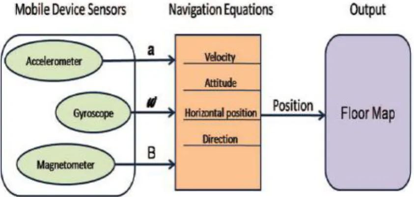
2.2.1 Kinematic navigation techniques
This technique use smartphone built-in sensors like accelerometer, gyroscope and
magnetometers to determine position, orientation and velocity of a moving project using
kinematic equations. Dead reckoning algorithm is used for navigating a moving device
[image:23.595.94.516.335.536.2]relative to unknown start point, orientation and velocity [9].
Figure 2.1: Kinematic navigation-based indoor navigation
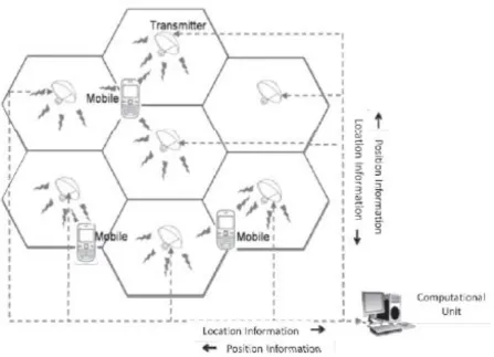
2.2.2 Wireless navigation techniques
This techniques use radio waves or light waves to determine user‟s position. This
approach is same as mobile phones is capable of transmitting and receiving signals inside
the buildings based on Bluetooth, RFID or Wi-Fi. Principles like Cell of Origin, Least
methods such as Received signal strength (RSS), Angle of Arrival (AoA), Time of Arrival
[image:24.595.84.532.120.443.2]and Time Difference of Arrival (TDoA) [9].
Figure 2.2: Wireless techniques for indoor navigation
2.2.3 Visual navigation techniques
This technique is like camera-based positioning techniques focuses on determining
the objects which are visible. Location information can be in encoded form (barcode or
QR-code).These code contains the information regarding the location and made this
technique more accuracy in positioning. The image as information can be digitized and