City, University of London Institutional Repository
Citation
:
Estebanez Camarena, M., Feetham, L., Scannapieco, A. and Aouf, N. ORCID:
0000-0001-9291-4077 (2018). FPGA-based multi-sensor relative navigation in space:
Preliminary analysis in the framework of the I3DS H2020 project. Paper presented at the
69th International Astronautical Congress (IAC), 1-5 Oct 2018, Bremen, Germany.
This is the accepted version of the paper.
This version of the publication may differ from the final published
version.
Permanent repository link:
http://openaccess.city.ac.uk/id/eprint/22014/
Link to published version
:
Copyright and reuse:
City Research Online aims to make research
outputs of City, University of London available to a wider audience.
Copyright and Moral Rights remain with the author(s) and/or copyright
holders. URLs from City Research Online may be freely distributed and
linked to.
City Research Online:
http://openaccess.city.ac.uk/
[email protected]
IAC-18- B2.IP-20-x46175
FPGA-based multi-sensor relative navigation in space: Preliminary analysis in the framework of the I3DS H2020 project
Mónica Estébanez Camarena*a, Luke M. Feethamb, Antonio F. Scannapiecoc, Nabil Aoufd
a Centre for Electronic Warfare, Information and Cyber, Cranfield University, Defence Academy of the United
Kingdom, SN6 8LA Shrivenham, Wiltshire, United Kingdom. [email protected]
b Centre for Electronic Warfare, Information and Cyber, Cranfield University, Defence Academy of the United
Kingdom, SN6 8LA Shrivenham, Wiltshire, United Kingdom. [email protected]
c Centre for Electronic Warfare, Information and Cyber, Cranfield University, Defence Academy of the United
Kingdom, SN6 8LA Shrivenham, Wiltshire, United Kingdom. [email protected]
d Centre for Electronic Warfare, Information and Cyber, Cranfield University, Defence Academy of the United
Kingdom, SN6 8LA Shrivenham, Wiltshire, United Kingdom. [email protected]
*corresponding author
Abstract
The Horizon 2020 Integrated 3D Sensors (I3DS) project brings together the following entities throughout Europe: THALES ALENIA SPACE - France / Italy / UK / Spain, SINTEF (Norway), TERMA (Denmark), COSINE (Netherlands), PIAP Space (Poland), HERTZ Systems (Poland), and Cranfield University (UK). I3DS is co-funded under the Horizon 2020 EU research and development program and is part of the Strategic Research Cluster on Space Robotics Technologies. The ambition of I3DS is to produce a standardised modular Inspector Sensor Suite (INSES) for autonomous orbital and planetary applications for future space missions. Orbital applications encompass activities such as on-orbit servicing and repair, space rendezvous and docking, collision avoidance and active debris removal (ADR). Simultaneous localisation and surface mapping (SLAM) for planetary exploration and general navigation in an unknown environment for scientific purposes can be considered in planetary applications. These envisaged space applications can be tackled by exploiting the flexibility, high performance and long product life of FPGAs. Conventional FPGAs are subject to Single Event Upsets (SEU) due to space radiation, causing their failure. Therefore, space-graded FPGAs, such as those developed by Xilinx, are targeted within the I3DS project. Currently, the main use of the FPGA within the development of this robust end-to-end multi-sensor suite is for navigation and data pre-processing. The aim of this paper is to assess the capabilities of FPGAs to carry out complex operations, such as running navigation algorithms for space applications. The motivation for the development of the on-board software architecture is as follows: raw data, acquired from the various sensors – including, among others, a High Resolution camera, a stereo camera and a LiDAR – is pre-processed to ensure the provision of robust and optimised inputs to 3D navigation algorithms. Noise reduction and conversion into suitable formats for the successful application of navigation algorithms are therefore the main aims of the data pre-processing. Some techniques adopted in this phase include outlier rejection and data dimensionality reduction for large point clouds, e.g. from LiDAR, and geometric and radiometric correction of the images from the cameras. The pre-processed data will then feed state-of-the-art relative navigation algorithms. Some of the proposed navigation algorithms include Generalised Iterative Closest Point (GICP) for dense 3D point clouds, relative positioning with fiducial markers, and visual odometry. The system environment for the preliminary operation is a test-bench setup formed by a standard desktop computer and a non-space-graded FPGA (Xilinx UltraZed-EG FPGA). The choice of FPGA was based on the similarity of this board to other space-graded ones also provided by Xilinx. Experimental tests on the algorithms are being performed in the framework of the validation campaign for the I3DS project. Preliminary results indicate that the data pre-processing can be efficiently carried out on the FPGA board.
Keywords: Relative navigation, on-board processing, autonomous, FPGA.
1. Introduction
In the context of this paper, relative navigation in space refers to the specific problem of determining the relative position and orientation of a chaser satellite, on which sensors will be mounted, in relation to a target satellite or a celestial body. The most relevant applications of this technology are rendezvous and docking with another spaceship, on-orbit servicing and
repair and active debris removal (ADR), and rendezvous with a celestial body.
69th International Astronautical Congress (IAC), Bremen, Germany, 1-5 October 2018.
view of autonomous resupply missions to the International Space Station and autonomous manned and unmanned missions to and from Mars [1].
Although significant advancement has been made from those early days, an increased level of autonomy in rendezvous and docking operations is still needed for future space missions. For example, as stated in [2], for a rendezvous happening at significant distances from the Earth, such as in the OSIRIS-REx mission, the time that a signal would take to be transmitted to the spacecraft creates the need for an autonomous operation. Furthermore, autonomous rendezvous could also lower the operational costs of a space mission [2].
Currently, robotic systems are shifting towards increased autonomy. This is the case for autonomous navigation, which has been widely studied in the literature and extensively implemented for ground applications, for example on cars or motorbikes. However, autonomous navigation in space poses a number of additional and different constraints that differentiate the problem from that of terrestrial applications. Indeed, the environment for a sensor on the ground is highly different to that of a sensor in space. While the former is surrounded by an immersive environment with multiple features and planes that can be used for mapping and localisation, because of the near-emptiness of space, the latter will mostly only detect the target satellite within a black, featureless background, which increases the difficulty in successfully carrying out relative navigation. In addition, the power and processing resources on-board spacecraft are more limited than a system on the ground, which restricts the possible data processing and navigation methods to use. Also, once a satellite is launched, on-orbit repairs are not normally feasible, and all its subsystems must remain in operation throughout the entire space mission lifespan, generally spanning many years. Furthermore, electronics used in space must be able to withstand the harsh conditions of the space environment, such as ionizing radiation, vacuum effects and large temperature gradients. Finally, because GPS is mainly designed for terrestrial use, its extra-terrestrial coverage cannot always be guaranteed. Unlike satellites in low Earth orbit (LEO), that can make use of GPS signals to achieve precision navigation, the use of these signals in higher altitude orbits is still in an early stage. An example of this is Navigator, a GPS receiver developed by NASA that is able to operate in altitudes up to geosynchronous equatorial orbit (GEO) [3].
The aim of this work is to develop and implement potentially computationally demanding data pre-processing and navigation algorithms on an FPGA in order to exploit its capabilities and assess the viability of using it to distribute the on-board processing load of a satellite in orbit.
The paper is structured as follows. First, the Integrated 3D Sensors project, within which this work has been developed, is introduced in Section 2. The designed system to tackle autonomous in-orbit relative navigation with an high-resolution (HR) camera, a stereo camera and a LiDAR, with a distributed processing structure that uses an FPGA and the satellite on-board computer, is described in Section 3. Then, Section 4 presents the experimental activities to obtain a preliminary assessment of the proposed solution. Finally, the achieved results are presented and discussed.
2. The Integrated 3D Sensors project
I3DS (Integrated 3D Sensors) is a project with the ambition to produce a standardised modular Inspector Sensor Suite (INSES) for autonomous orbital and planetary applications for future space missions. The project is co-funded under the Horizon 2020 EU research and development program and is part of the Strategic Research Cluster on Space Robotics Technologies as Operational Grant n°4 among 6 [4].
The project involves ten European partners, including Thales Alenia Space (France, Italy, UK and Spain), SINTEF (Norway), TERMA (Denmark), Cosine (Netherlands), PIAP Space (Poland), HERTZ Systems (Poland), and Cranfield University (UK) [5].
The developed INSES will be formed by different building blocks, each one corresponding to a different sensor, with a common interface. The main goal of the sensor suite is to autonomously recognize its environment and localise itself within it. The sensor suite is designed for both orbital and planetary scenarios. Orbital applications encompass autonomous rendezvous and capture of a spacecraft, either for on-orbit servicing, structure assembly and cooperative capture (cooperative targets) or for active debris removal (ADR) and celestial bodies rendezvous (non-cooperative targets). Planetary applications refer to planetary surface exploration. In both cases, the I3DS suite must be able to perform autonomous absolute navigation and relative positioning and orientation with respect to a target body [6].
Sensors conforming the INSES are visual sensors (stereo camera, high-resolution camera and thermal infrared camera), contact sensors (force and torque sensor and tactile sensors), absolute sensors (star tracker and inertial measurement unit) and relative sensors (Radar, LiDAR and time of flight camera). All sensors are interfaced with an Interface Control Unit (ICU), in charge of acquiring the data captured by the sensors and pre-processing it. The ICU also has a high-performance multiprocessor system-on-chip (MPSoC) and field-programmable gate array (FPGA) for sensor control, data processing and interfacing with the on-board computer (OBC) [7].
means of illumination is added to the sensor suite. This includes a pattern projector and a wide-angle torch. Pattern projection can be used together with the high-resolution camera for navigation purposes, through the creation of 3D point clouds. The wide-angle torch provides general illumination to enable the use of the visual cameras without the satellite being in sunlight [7]. After the development and testing, the sensor suite will fly as part of the In-Orbit Demonstration (IOD) in the timeframe 2023-2024 [7].
3. System design
The work presented in this paper focuses on the rendezvous in close-proximity. A subset of sensors, namely the LiDAR, the HR camera and the stereo camera, are considered for a preliminary study of the capability of an FPGA to carry out the pre-processing of the data acquired by these sensors, as well as posterior navigation algorithms using these data. The main advantages of an FPGA for space applications is its re-programmability and structure that allows for parallelization, and so higher performance than an application-specific integrated circuit (ASIC) may be achieved. These characteristics also result in a final lower cost than for an ASIC. However, FPGAs are very sensitive to single-event upsets (SEUs) due to space radiation, that can cause a bit flips in configuration cells. With the development of re-programmable FPGAs with over a million system gates and space-rated FPGAs that are resistant to radiation provided by companies such as Xilinx, their use in space has become more feasible [8].
The raw data produced by this subset of sensors must first be pre-processed in order to remove distortion coming from the sensor itself and mitigate possible noise or spurious features and convert it into a format more convenient for the posterior navigation algorithm. The outcome of the pre-processing and navigation pipeline is the relative pose, expressed as translation T and a rotation
R, of a target satellite with respect to the chaser satellite on which the sensors are housed. Within the I3DS project, the computational frequency of the overall processing pipeline, from raw data to the navigation solution, should be at least 10 Hz to be able to cope with fast moving targets.
3.1 System architecture
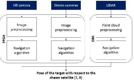
The architecture of the proposed solution is based on a subset of sensors and makes use of both a FPGA board and a conventional on-board computer. Image processing and visual navigation algorithms are tested on the FPGA board for both the HR camera and the stereo camera. LiDAR data pre-processing and navigation are tested on the on-board computer, for being more computationally expensive than the visual processing tasks. In this way, the computing load is distributed and the whole process from data acquisition to pose determination should be
[image:4.612.317.545.106.242.2]faster and more oriented to real-time applications. The proposed design is shown in Fig. 1.
Fig. 1. Proposed system design for the case under test.
3.2 Software design
3.2.1 Data pre-processing
In order to ensure that navigation algorithms receive inputs free from errors and noise, the data acquired by the sensors must be pre-processed first. The main goals of data pre-processing are optical correction, noise reduction and conversion into suitable formats for the later application of navigation algorithms.
3.2.1.1 Image pre-processing
Once the images are acquired by the cameras, they are first geometrically corrected from possible distortions derived from imperfections in the manufacturing process of the imaging system. This is done using lens distortion correction. Thereafter, histogram equalisation is applied to adjust the contrast of the image using a pixel intensity histogram. Finally, noise reduction is achieved using bilateral filtering, that in contrast with a standard Gaussian noise-reduction algorithm uses not only spatial information, but also intensity information. Additionally, stereo rectification is performed on the stereo images.
3.2.1.2 Point cloud pre-processing
After being acquired by the LiDAR the point clouds undergo three different pre-processing operations. Firstly, NaN (not a number) removal checks the data for any error in the points and removes them if there are any. Secondly, the data is down-sampled using a uniform sampling algorithm, in which the point cloud is divided into voxels and each voxel is represented by its centroid in the new point cloud. Finally, a statistical outlier removal filters spurious features, normally due to acquisition errors, out of the point cloud.
3.2.2 Navigation algorithms
69th International Astronautical Congress (IAC), Bremen, Germany, 1-5 October 2018.
3.2.2.1 HR monocular navigation
HR camera monocular navigation is mainly based on the exploitation of fiducial markers to estimate the pose of the target. Two different sets of fiducial markers are used, in order to tackle situations of close-proximity and very-close-proximity, when not all markers could be in the field of view. The pose is retrieved with the perspective-n-point (PnP) method.
3.2.2.2 Stereo navigation
Stereo-based navigation exploits visual odometry to obtain the relative pose of the target with respect to the chaser. First, stereo matching is obtained between features in a stereo pair, then the matches are tracked in successive stereo pairs, thus enabling the computation of a transformation matrix, which encapsulates translation and rotation.
3.2.2.3 LiDAR navigation
Different point cloud registration algorithms have been tested for LiDAR navigation. Namely, the extensively employed classical Iterative Closest Point (ICP) [10], Generalised ICP (GICP) [11], Trimmed ICP (TICP) [12] and a Kalman filter-based registration that uses a Histogram of Distances [14] point descriptor developed at Cranfield University [13] [14].
4. Proposed test, hardware and software
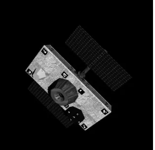
The tests have been carried out on data simulated with software provided by Thales Alenia Space France for the monocular HR camera (see Fig. 2), the stereo cameras and the LiDAR. The size of all images is 2048pixels x 2048pixels and the raw point clouds have 152100 points. The simulated trajectory is a straight-line approach trajectory of the chaser towards a target satellite, from a distance of 20 m, without any rotational motion. The approach velocity is 0.05 m s-1. The target satellite
[image:5.612.107.264.541.693.2]features fiducial markers on its surface to support visual navigation, especially in the case of monocular visual odometry as a means of overcoming scale ambiguity.
Fig. 2. Target satellite. Example of HR image simulated with software provided by Thales Alenia Space France.
The test bench to simulate the system described in Section 3.1 is formed of the Xilinx UltraZed-EG FPGA board and an 8x Intel® Core™ i7-6700 CPU @ 3.40 GHz desktop computer with Ubuntu 16.04.4 LTS to simulate the OBC. The choice of the UltraZed-EG FPGA was based on the fact that although this model is not space-rated, Xilinx also provide some space-rated FPGA boards for which the developing tools are the same as for the Ultrazed-EG.
As for the development environment, the OpenCV library has been used throughout the image-processing pipeline, including pre-processing and navigation, and the Point Cloud Library (PCL) library has been used for point cloud processing. The image processing applications for the FPGA board have been developed using Xilinx Software Development Kit (SDK). The operating system on-board the FPGA board is Petalinux.
5. Results of simulations
A thorough analysis on the speed performance of the proposed solutions has been carried out on the FPGA and the desktop computer. The tests involved resizing the images and down-sampling the point clouds to assess how the time of processing is influenced. At the same time the aim was to understand if the overall performance could be degraded with less resolution in the raw and pre-processed data.
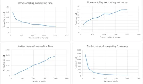
Fig. 3 shows the time and the frequency required to pre-process point clouds. The down-sampling is depicted as function of output points and the plots demonstrate that to have a point-cloud with a very small number of points more time is required, since more points have to be merged together. Conversely, outlier removal is faster when done on smaller point clouds, as could be expected. For both point-cloud pre-processing algorithms an output point cloud with a number of points between 1500 and 2000 gives a frequency that is in line with the aims of the I3DS project. However, it has to be stated that handling large point clouds is more demanding in terms of computational power, so the results are relative to the desktop station.
situations, lead to a significant amplification of image noise.
Concerning navigation algorithms, the performance in terms of computing time are shown in Fig. 5. It is worth noting that the performance is assessed on the FPGA for the HR and stereo camera, whilst the desktop station is used for the LIDAR. As expected, the frequency increases when the images or point clouds are smaller. It is worth noting that both algorithms could be faster. In particular, stereo navigation can be slowed down by the size of the search windows for stereo matching and for temporal feature tracking. A smaller size of search windows can of course increase the frequency as well. This suggests that fine tuning of the parameters with smaller images should be done. However, stereo navigation should have more relaxed requirements as shown in [9], therefore making the results still positive. It is clear, though, that the speed of execution on FPGA is not yet that which is desired in the
project. Therefore, these algorithms should be possibly be run on the OBC. For pre-processed HR and stereo images of size 0.8 Mpix, the average computation time for HR navigation is 1.60 s/frame while for stereo navigation 1.76 s/frame for stereo navigation. The point cloud navigation solution for LIDAR was tested on the desktop computer. The results show that despite more computation power, the processing times are still quite far from requirements. It is however expected, since point cloud registration is not a fast process.
[image:6.612.73.538.304.579.2]Given these results, it is evident that more computational power and even more refined tuning are necessary. Further analysis with the appropriate hardware would be necessary to assess its real capabilities. Also, a possible solution that could be investigated in the future would consist in parallelizing the processes running on the FPGA and using more than one board, in order to reduce the overall computing time and meet the project requirements.
69th International Astronautical Congress (IAC), Bremen, Germany, 1-5 October 2018.
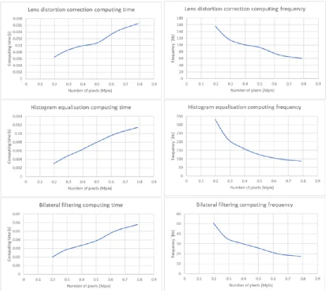
Fig. 4. Computing times for image pre-processing algorithms.
Conclusions
The present paper has presented results of a preliminary analysis of computation performance for the pre-processing and navigation algorithms in the framework of the H2020 I3DS project. The main aim is to achieve very precise relative navigation in space with a sensor suite architecture different from the traditional mission-specific SoC architecture.
This preliminary analysis dealt with the assessment of a FPGA to carry out some of the processing load in an end-to-end navigation solution using an HR camera and a stereo-camera, in combination with point cloud LiDAR
processing on a different and more powerful machine. The designed software architecture has been tested against a straight-line approach trajectory for navigation where the chaser satellite moves towards the target satellite from a 20 m distance.
Fig. 5. Computing times for all HR, stereo and LiDAR navigation algorithms. The visual navigation (HR and stereo cameras) is computed on the FPGA whereas the LiDAR navigation is performed on the desktop computer.
Acknowledgements
This project brings together the following companies throughout Europe: Thales Alenia Space – France / Italy / UK / Spain, SINTEF (Norway), TERMA (Denmark), COSINE (Netherlands), PIAP Space (Poland), HERTZ Systems (Poland) and University of Cranfield (UK).
I3DS is co-funded under the Horizon 2020 EU research and development program and is part of the Strategic Research Cluster on Space Robotics Technologies as the Operational Grant nº 4 among 6. It has received funding from the European Union’s Horizon 2020 research and innovation program under gran agreement Nº 730118.
References
[1] M. E. Polites, An Assessment of the Technology of Automated Rendezvous and Capture in Space, 1998, NASA, Marshall Space Flight Center, Marshall Space Flight Center, Alabama.
[2] Daniel Hoffpauir, Tomorrow's technology will build on historical breakthroughs, 2015, Space Rendezvous, 2015 NASA Engineering & Safety Center (NESC) Technical Update, https://www.nasa.gov/offices/nesc/articles/space-rendezvous, (accessed 20.09.18).
69th International Astronautical Congress (IAC), Bremen, Germany, 1-5 October 2018.
[4] I3DS Integrated 3D Sensors, What’s I3DS?, 2018, http://i3ds-h2020.eu/about-us, (accessed 15.08.18). [5] I3DS Integrated 3D Sensors, Partners, 2018,
http://i3ds-h2020.eu/about-us , (accessed 15.08.18). [6] D1.2: Use-case Identification, I3DS “Integrated 3D
Sensors suite”, 2017, COMPET-4-2016: SRC - Space Robotics Technologies – “Inspection Sensor Suite”. Grant Agreement n° 730118,
http://i3ds-h2020.eu/images/OG4_I3DS_D1.2-Use_case_Identification_PublicRelease.pdf (accessed 24/09/2018)..
[7] D2.4: Design Description Document, ICD Details,
I3DS “Integrated 3D Sensor suite”, 2017, COMPET-4-2016: SRC - Space Robotics Technologies – “Inspection Sensor Suite”. Grant Agreement n° 730118,
http://i3ds-h2020.eu/images/OG4_I3DS_D2.4-
Design_Description_Document_ICD-details_PublcRelease.pdf (accessed 24/09/2018). [8] S. Habinc, Suitability of reprogrammable FPGAs in
space applications, Feasibility Report, 2002, Gaisler Research, European Space Agency contract report. [9] A.F. Scannapieco, L. M. Feetham, M. Estébanez
Camarena, N. Aouf, Space-oriented Navigation
Solutions with Integrated Sensor-Suite: the I3DS H2020 Project, IAC-18- C1.IP-20-x46161, 69th International Astronautical Congress, Bremen, Germany, 2018, 1 – 5 October.
[10] P. Besl, N. McKay, A Method for Registration of 3-D Shapes, 1992, IEEE Trans. Pattern Analysis and Machine Intelligence, 14 (1992) pp. 239–256. [11] A. Segal, D. Haehnel and S. Thrun,
Generalized-ICP, 2009, Robotics: Science and Systems, Seattle, WA, USA, June 28 - July 1, 2009.
[12] D. Chetverikov, D. Svirko, D. Stepanov, P. Krsek, The Trimmed Iterative Closest Point algorithm, 2002, Object recognition supported by user interaction for service robots, Quebec City, Quebec, Canada, 3 (2002) pp. 545-548.
[13] A. Amamra, N. Aouf, D. Stuart, M. Richardson, A recursive robust filtering approach for 3D registration, 2016, Signal, Image and Video Processing, 10 (2016) pp. 835-842.