THE ARCHAEOLOGY OF CANIA GORGE: AN OVERVIEW
CATHERINE WESTCOTT, IAN LILLEY AND SEAN ULM Aboriginal and Torres Strait Islander Studies Unit, University of Queensland,Brisbane, Queensland, 4072, Australia
This paper presents a general overview of archaeological investigations in the Cania Gorge region, located on the western margin of the Gooreng Gooreng Cultural Heritage Project study area. It includes a physical description of the region and a brief outline of the cultural setting, before presenting a summary of archaeological investigations undertaken in the area.
Introduction
Cania Gorge is the focus of the inland archaeological investigations conducted under the auspices of the Gooreng Gooreng Cultural Heritage Project. The gorge is located 20km north-northwest of Monto in Central Queensland, at approximately 24"401 south and 15 1
"
east. It lies on the eastern side of the Great Dividing Range, about 120krn from the coast, in the upper Burnett River Basin. Most of the gorge lies either in Cania Gorge National Park, Cania Station or in surrounding State Forest. The area is on the western boundary of land traditionally identified as the country of Gooreng Gooreng speakers at the time of European contact, bordering on Gangulu and Wuli- Wuli countries to the west (Horton 1994; Williams1981).
The gorge consists of dissected sandstone escarpments, covering an area of approximately 5,000ha (Figures 1-2). It is a broad, shallow gorge, with Three Moon Creek, the main watercourse, flowing through open eucalypt woodland and edged by alluvial flats. Three Moon Creek is fed by tributaries flowing from side gullies. Some of these gullies and well-watered sections of the creek provide a moist, cool environment for ferns and dry vineforest. In 1979 the Cania Dam was built at the northern end of the gorge, regulating the flow of Three Moon Creek and dramatically altering local hydrological regimes and patterns of erosion and sedimentation.
Physical Setting Geology
The Monto region exhibits a complex mixture of metamorphic, igneous and sedimentary rocks. The base of the Cania district sediments is derived from predominantly volcanic activity. It comprises Palaeozoic sediments, mainly cherts and submarine lava flows, overlain by andesitic and basaltic lavas (Dear 1959:98). Ln the Cania area, Permian sediments and volcanics are estimated to be 3,000m thick. The beds consist of greywacke, siltstone, argilite, rhyolitic tuff, black calcareous mudstone, andesites and tuff (Malcolmson l970:2). The youngest beds are Tertiary volcanic flows, mainly basaltic (Dear 1959:99). A
cross-section of the substrate shows a number of broad, gently arched anticlines and synclines. The folds are cut by longitudinal high-angle thrusts and tensional cross-faults, resulting in extensive outcropping of all layers of rocks (Dear 1959:7; Malcolmson l970:2).
Climate
The Cania district experiences a sub-tropical, sub- humid climate, with long, hot, wet summers and mild, dry winters. The Three Moon Creek catchment area has an average rainfall of approximately 800mm, with about two-thirds occurring between November and April. Droughts are a regular feature of the district. Prior to the building of the Cania Dam, Three Moon Creek was prone to flooding during the summer wet season (Malcolmson 1970:Section 3-1; Smith and Kent 19935).
Vegetation
The vegetation of the Cania district has been significantly modified by recent non-Aboriginal land- use including grazing, mining and forestry. Selective ringbarking and clearing are generally confined to lower slopes and the valley floor. Fire is commonly used as a management tool (I&WSC 1971). Alluvial soils adjacent to Three Moon Creek are chiefly clay and sandy loams. Timber cover is sparse and consists of riverine open forest, predominantly Queensland blue gum (Eucalyptus tereticornis) with sporadic gum-topped box (E. pilligaensis) and poplar box (E. populena). Forest blue grass (Dichanthium sericeum) is the dominant grass species on the alluvial flats (Malcolmson 1970:Section 4-4; Smith and Kent 1993:18), along with slender bamboo grass (Stipa verticillata) and kangaroo grass (Thenzeda australis) (I&WSC 197 1 ). Around the gorge, the soils are sandy clay loams with a sandstone and siltstone substrate. The undulating plains and dissected hills on top of the escarpment support open forest, mainly narrow-leaf ironbark (Eucalyptus crebra) and poplar box, with occasional silver-leaf ironbark (E. nzelanophoia), white gum (E. platyphylla), pink bloodwood (E. intermedia) and Queensland blue gum, typical of Central Queensland's extensive sandstone belt (Smith
and Kent 1993:21). At the base of the escarpments, areas of rainforest are found. Many of the plants from these areas have not been reported as growing elsewhere in the Burnett region (I&WSC 1971).
Fauna
The building of Cania Dam and land clearing has disturbed or altered animal habitats in many parts of the gorge. Grazing of cattle (Bos taurus and B. indicus) continues in many parts of the gorge. Although no detailed studies have been undertaken in Cania Gorge, the nearby Kroombit Tops State Forest has been subject to limited fauna surveys (Schultz 1994) where similar species to those observed in Cania Gorge were reported. Four species of macropod inhabit the gorge, the eastern grey kangaroo (Macropus giganteus), whiptail wallaby (M. parryi), swamp wallaby (Wallabia bicolor) and the nocturnal rufous bettong (Aepypqmnus rufescens). The gorge has three large possum species, the common brushtail (Trictzosurms vuulpeeulaj; mountain brushtai4 (T. canius) and ringtail (Pseudocheirus peregrinus). The gorge also has two monotremes, the common echidna (Tachyglossus aculeatus) and the platypus (Omithorhynchus anatinus). The birds are typical of drier southeast Queensland open forest habitats, with little evidence for invasion by exotic bird species. Larger species of fish have succumbed to the environmental changes brought on by the building of the dam and competition from species introduced to stock the dam. Rainbowfish (Melanotaenia sp.) still inhabit Three Moon Creek. The one large native species of fish still present is the jewfish (Tandanus tandanus), but it is unclear if it is endemic or locally introduced.
Cultural Setting
The Burnett-Curtis area is traditionally associated with a group known variously as the Gooreng, Gurang, Koreng-koreng and Kooranga (Mathew 19 10; Tindale 1974). People camped and travelled in groups of varying sizes, according to seasonal patterns. In historical times people regularly travelled from the coast to the hinterland, exploiting bush foods along the way (Williams 1981).
The Upper Burnett was traversed by Thomas Archer in 1848 and was settled by Europeans soon after (Johnston 1982:3). The original properties of Rawbelle, Dalgangal-Cannindah and Cania ran sheep until 1883, when cattle were introduced (Malcolmson 1970:Section 1-1). Pastoral expansion resulted in clashes with the Aboriginal owners of the area and the early years of settlement were characterized by continual conflict between the two groups. Aborigines raided settlers and their stock, while the pastoralists shot and poisoned the Aboriginal
population (Williams 198 1 :6-8). During the 1 MOs, the Native Mounted Police helped to quell Aboriginal resistance, and by 1860 the Europeans had generally established control of the area (Denholm 1972:355- 356; Williams 1981 : 12-13).
The Cania area was mined for alluvial gold from the 1870s until the early years of this century (de Havelland 1987:227-229). Mining activities were less disruptive to the Aborigines than pastoral settlement and, with Aboriginal resistance already reduced, Aborigines and miners enjoyed relatively good relations (Williams 198 1 :20-21).
Under the Aborigines Protection and Restriction of the Sale of Opium Act 1897, reserves were set up and some of the Aborigines from Gooreng Gooreng country were sent to Cherbourg (then Barambah) or Woorabinda (Williams 198 1 :24). This removal caused the separation of families, many of whom are still seeking reunions today. Aborigines not moved to reserves often attached themselves to the stations established oii $heir traditional !afids (Williams
1981:28).
The Aboriginal people in the Burnett-Curtis region today speak dialects which they identify as Gooreng Gooreng, Waka Waka or Wuli Wuli. There are many similarities among these dialects. Language is being recorded with the help of present-day speakers and is helping to maintain cultural continuity (Jolly 1994; Williams 198 1:36-37).
Oral traditions among the Gooreng Gooreng are also being recorded. They include stories that tell of the Rainbow Snake, sorcery practices, drought and the search for water, as well as post-contact stories of massacre by Europeans (Clarkson et al. in prep.; Williams 198 1 :38-39). Aboriginal sites of significance have been identified by Williams (1981:37-40; see also Clarkson et al. in prep.), including carvings, art sites, natural formations and landscapes that are significant owing to their role in stories or historical events, or traditional or contemporary use. Engraved rocks removed from the Burnett River are in the process of being returned to the traditional owners (Ulm and Lilley 1996).
Archaeological Surveys and Excavations
Prior to the studies of the Gooreng Gooreng Cultural Heritage Project, Cania Gorge was unknown archaeologically apart from the incidental recording of one rock art site in the early 1980s and second- hand comments reported by Walsh (1984).
Systematic archaeological investigations in the Cania Gorge area were initiated in 1995 under the auspices of the Gooreng Gooreng Cultural Heritage Project to assess the archaeological research potential of the region, primarily to augment an understanding of sites in the region, until that time based on coastal
Figure 1. Southern Cania Gorge, showing recorded archaeological sites.
- -
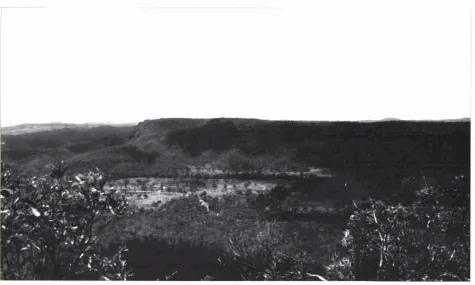
Figure 2. General view of Cania Gorge, facing north (Photograph: S. Ulm).
sites (see Lilley and Ulm 1995). The mitial surveys provided the basis for a subsequent program of test excavation which aimed to investigate questions concermng the nature, extent and antiquity of subsurface cultural remalns and the age of the rock
art. In total, 52 days of archaeological survey and excavation were conducted in the Cania Gorge area between July 1995 and July 1997.
Survey Results
Surveys in the Cania Gorge region resulted in the documentation of 23 Aborigmal cultural heritage places, 21 of wh~ch had not been previously recorded (Append~x A). The 'Site ID' in the first column of Appendix A 1s the Gooreng Gooreng Cultural Heritage Project file number. The 'CG' prefix stands for 'Cania Gorge'.
Surveys targeted the change of slope along the base of the ewarpment where weathering is conducive to shelter formation and visibility is high, although extenswe areas of talw lope, areas on the top of the escarpment, creek banks and creek erosion- faces were also examined. Wh~le numerous rockshelters containing archaeolog~cal depos~ts were located at the base of the escarpment, very little material was observed in open contexts and what there was appeared to be s~tuated in reworked deposits. It is thought that regular floodmg and down- cutting of Three Moon Creek in the past may have had a negative impact on the preservation of open sites on the valley floors border~ng creek margins.
Excavation Summary
Ten rockshelters in Cania Gorge have been test excavated withm a 15km2 area at the southern end of the gorge (Figure I): Roof Fall Cave, Big Foot Art Site, Grinding Groove Cave, Boulder 1, Bushranger's Cave, Contact Cave, Fern Tree Pool Shelter, Long Gallery, Plcnic Art S ~ t e and Road Cave 1. A total of 17 radiocarbon determinations on charcoal samples has been obtamed from these sites, revealing an occupational sequence spanning the period from the Last Glacial Maximum 18,000 years ago to the contact period (Appendix B). All are conventional liquid sc~nt~llation determinations with the exception of NZA799l at Grinding Groove Cave, which is an Accelerator Mass Spectrometry (AMS) date. Brief summaries of the excavations are presented below.
Roof Fall Cave
Roof Fall Cave is a large sandstone shelter located approximately 80m south of the recorded Big Foot Art Site (JE:AO7) on Cedar Creek (Figure 1). The walls of the shelter exhibit a number of painted motifs and the floor, which covers an area of approximately 40m2, is dominated by blocks of
rapidly-weathering sandstone detached from the ceiling of the shelter. The site has been
the
subject of excavations in two separate field seasons. The first (SquareA)
was excavated in September-October 1996, close to the centre of the chamber. P extended to a maximum depth of about 80cm, where it reached culturally-sterile sediments an undetermined depth above bedrock. A further two pits (Squares B and C ) were excavated in July 1997. They were oriented as a trench perpendicular to the rear wall below a rock art panel to try to determine the age of the art by association with excavated ochre. Large quantities of stone artefacts, animal bone and charcoal were recovered, along with some freshwater mussel shell and ochre.Seven radiocarbon dates have been obtained from Square A spanning from 18,576 cal BP (Wk-5216) to the present (Appendix B). Analysis of Square
A
has revealed significant changes in the distribution of cultural material through time. For further details see Eales cr a/. ( t h s volume; also Eales 1998).Big
Foot Art SiteBig Foot Art Site is a recorded rock art site (JE:A07) on Cedar Creek (Figure I). The rockshelter has formed at the base of a dissected sandstone escarpment and has a floor area of approximately 20mZ within the dripline, dipping slightly towards the front of the shelter. A single 50cm x 50cm test pit (Square 15) was excavated in the January 1996 field season to a maximum depth of 70cm before encountering impenetrable roof fall. This small sample was augmented by a further two contiguous 50cm x 50cm test excavations (G6 and G7) dug to bedtock adjacent to the original square in September- October 1996. Excavation revealed a cultural assemblage domnated by flaked stone artefacts of diverse lithology. quantities of bone (burnt and unburnt), abundant charcoal, and small amounts of ochre. Four radiocarbon dates are available for the first test excavation, demonstrating occupation spanning from at least 7,787 cal BP (Wk-4638) to 300 cal
BP
(Wk-4889; see Appendix B).After observing significant numbers of stone artefacts on the surface of the talus slope immediately below the shelter entrance, a 50cm x 50cm pit was excavated towards the base of the slope to determine whether any subsurface cultural material existed in this area (the excavation was designated in the field as 'Big Foot Boulder'). The excavation yielded negligible quantit~es of cultural material and no dates have been obtamed from this square. A detailed technological analysis of the lithic assemblage from Square I5 has recently been completed. Detailed results are presented in Westcott, Lilley et al. (this volume; also Westcott 1997).
Figure 3. General view of Grinding Groove Cave Figure 4. Grinding grooves at Grinding Groove
[image:5.596.303.543.65.226.2] [image:5.596.103.219.292.460.2] [image:5.596.303.543.294.451.2] [image:5.596.38.285.542.703.2] [image:5.596.366.476.544.707.2](Photograph: S. Ulm). Cave (Photograph: S. Ulm).
Figure 5. General view of Road Cave 1 Figure 6. General view of rockshelters at the
(Photograph: S. Ulm). break of slope along the base of the escarpment.
Road Cave 1 is shown on the extreme left of the frame (Photograph: L. Tebble).
Figure 7. General view of Boulder 1 (Photograph: Figure 8. General view of Contact Cave
I. Lilley). (Photograph: I. Lilley).
Grinding Groove Cave
Gnnding Groove Cave is located approximately 40m north of Three Moon Creek, directly opposite Road Cave 1 (Figures 1, 3-4). Grinding Groove Cave is a relatively small shelter with deposits covering an area of approxrmately 25m2 within the dripline. The shelter is joined by a narrow crevice along a fault h e in the low escarpment to another shelter exhlb~ting archaeological deposits about IOm to the west (Contact Cave, see below). During initial recordingof the site, a number of water-rounded stones exhibiting Impact pitting and use-wear (phytolithic polish) were observed around the rear wall of the shelter and one was apparently cached on a small shelf of sandstone at the entrance to a narrow crevice on the western wall of the shelter. Several stone artefacts and whole freshwater mussel shell valves were also noted in the loose surface sediment. Several large preces of roof fall are evident at the front centre of the shelter at the top of the talus 4ope. forming a sediment trap for materiai in the shelter. Three stones, two within the dripline and one about 5m in front of the shelter, exhibit axe grinding grooves.
A single 50cm x 50cm test pit (Square A) was opened in the front centre of the shelter in the June- July 1997 field season to a maximum depth of 70cm before excavations ceased owing to the technical difficulty of digging a 50cm x 50cm pit beyond this depth. Excavation revealed a cultural assemblage dominated by flaked stone artefacts of diverse lithology, quantities of bone (burnt and unburnt), abundant charcoal, fragmented and whole freshwater mussel shell and small amounts of ochre. Two discrete hearths were also encountered. A sample of charcoal from a hearth located at the base of the excavations submitted for Accelerator Mass Spectrometry (AMS) dating returned an age of 2,756 cal BP (NZA-7991; see Appendix B).
If this determination accurately dates the hearth it indicates a locally-anomalous feature at the site. Material from a simlardepth in Big Foot Art Site and Roof Fall Cave has been dated to 7,787 and 18,576 cal BP respectively, implymg that the Grinding Groove Cave deposlt accumulated at a much faster rate over the last 3.000 years than other rockshelter deposits in the southern Canla Gorge system. In fact. the rate of accumulation of the deposit (assuming that the surface of all deposits represents 0 RP) 1s almost 2.5 times faster than the next most rapidly- accumulating deposit (Road Cave 1. Square B) and almost 6.5 times faster than the entire sequence represented by Roof Fall Cave, Square A (see Lllley
e r a / . 1997).
There is some concern that the date is aberrant. as rt may measure the age of lntrusrve charcoal derived from upper strat~graphic unlts. possibly moved
downwards by extensive wasp burrowing noted throughout the stratigraphic unit above that from which the date was obtained. However, littleevidence for insect actrvity was noted in the stratigraphic unit from which the sample was taken. In additton, the sample is derived from a hearth which appeared to be stratigraphically discrete. The validity of the date could be further tested by dating a whole valve of freshwater mussel shell from an upper unit (e.g. XU9), though dating freshwater mussel has its own problems.
It can also be noted that the archaeological material associated with the date, however, conforms with results from Big Foot Art Site and Roof Fall Cave, where faunal evidence is restricted to about the last 4,000 years. Excavationof Grinding Groove Cave revealed vertebrate and invertebrate faunal material to the base of excavations (see Chicoteau 1998a,
1998b). Further excavations are planned for this site to identify the base of cultural deposits and retrieve samples whrch should help resolve the J a ~ i n g question.
Road Cave
I
Road Cave I is one of a series of small rockshelters located in a road reserve immediately south of Cania Gorge National Park on the south side of Three Moon Creek, about lkm east of the Big Foot Art Site (Figures 1,5-6). Two 50cm x 50cm test p ~ t s (Squares A and B) were excavated to bedrock in January 1996. The excavated assemblage mcludes many stone artefacts made on a range of raw materials, large quantities of bone, mainly burnt, and some freshwater mussel shell.
Four radiocarbon dates were obtained, three from Square B and one from Square A. The latter and the two uppermost dates from Square B overlap and are thus stat~stically identical despite the difference in the depths from which the samples were obtained. The bottom date in Square B is substantially older than the other three determinations from the site, though from the same depth below the surface as the date obtalned from Square A. The meaning of these results i~ yet to be fully determined, but there 1s no reason at this stage to believe that their interpretation will not be straightforward. The ages 928 cal BP (Wk-4883). 1,067 cal BP (Wk-4882) and 2,914cal B P (Wk-4637) are from Square A, and indicate an earlier phase of slower deposition lies below a later phase in which deposition was more rapld (Appendix
B).
The date of 1,057 cal BP (Wk-4884) was obtained from the nearby Square B, and is probably indicative of nothing more than the sloping stratigraphy of the deposlt, which places matenal of quite recent age in t h ~ s pit at the same depth below surface as more ancient material slightly upslope.Figure 9. General view of Picnic Art Site Figure 10. Completed -- vatio ion at Picnic Art
(Photograph: S. Ulm). Site, Squares A and B (Photograph:
S.
Ulm).Figure 11. General view of excavations in progress Figure 12. General view of Long Gallery a t Bushranger's Cave (Photograph: S. Uhn). (Photograph:
S.
ULm).
Figure 13. General view of Crevasses Art Site Figure 14. General view of Jamieson's Cave
(Photograph: S. Ulm). (Photograph: S. Ulm).
Boulder 1
The site designated as Boulder 1 is located just north of Gorge Oaky Creek (Figures 1,7). The site consists of two massive boulders which detached from the main escarpment at an unknown time andcame to rest against each other to form a sediment trap. Two 50cm x 50cm teqt pits (Squares A and B) were excavated in January 1996, one on each side of the site, to maximum depths of 56cm and 34cm respectively. Excavation revealed low rates of discard of cultural material, including stone artefacts and bone, and a basal age on charcoal of 3,465 cal BP (Wk-4878; Appendix B).
Contact Cave
Contact Cave is located on the north side of Three Moon Creek, directly opposite Road Cave 1 (Figures
1,8). The name of the rockshelter is derived from the identification of qeveral apparently flaked artefacts made on bottle glass which were found in a recessed area in the extreme west of the shelter. The shelter is 10m long and less than 3m wide within the dripline, with wide frontage to Three Moon Creek approximately 40m to the south. A single 50cm x 50cm test pit (Square A) was excavated in July 1997 to a depth of 53cm against the rear wall of the shelter. The excavation yielded a diverse assemblage consisting of stone artefacts (including aquartz core), fish bone and scales, freshwater tortoise carapace, freshwater mussel shell, charcoal and hone. These results indicate extensive use of rivenne resources in the recent past. No radiometric dates have been obtained for this site. Materials excavated from this site are awaiting full analysis, but it warrants further excavation.
Picnic Art Site
Picnic Art Site is a small and very low-roofed rockshelter located at the base of the escarpment above the Cania Gorge National Park picnic area on the north side of Three Moon Creek (Figures I, 9-10). The site contains three small art panels, including two hand prints. Cattle faeces evident on the surface of the deposit suggest that the animals use the shelter for scratching, which may be detrimental to one of the exposed art panels. Layers of white, yellow and red chalky rock are visible in the back of the shelter and it is possible that this material is associated with the production of art. Several water-rounded cobbles were noted on the surface of the rockshelter.
Two contiguous 50cm x 50cm test pits (Squares A and B) were excavated in January 1996 close to the front of the shelter. to a maximum depth of approximately lOcm before encountering a large slab of roof fall. Excavations continued for a further 20cm in the extreme southwestern comer of Square A,
where the edge of the roof fall slab was located. Excavation yielded extremely small samples of cultural material, including a few stone artefacts and some bone. It is possible that more abundant cultural material lies below the roof fall. No radiometric dates have been obtained for this site. Materials excavated from this site are awaiting full analysis, but the site warrants further excavation.
Bushranger's Cave
Bushranger's Cave is a large, double-chambered rockshelter located on a remote bush walking track in State Forest near the headwaters of Gorge Oaky Creek (Figures 1, 11). Two contiguous 50cm x 50cm test pits (Squares A and B) were excavated in January 1996, to gain access to deep deposits at the site. Very little cultural material was recovered, although some European material was evident in the excavation units immediately below the surface. No radiometric dates have been obtained. Materials excavated from this site are awa~ting full analysis.
Long Gallery
The Long Gallery (also 'The Gallery') is a long, narrow rockshelter located approximately 50m west from Picnic Art Site along the base of the escarpment on the north side of Three Moon Creek (Figures 1, 12). No cultural material was observed on the surface of the site, which is dominated by massive blocks of roof fall. A single 50cm x 50cm pit (Square A) was excavated in January 1996 at the rear of the shelter. Although no cultural material was documented during excavation, it is possible that full analysis of the sediments may reveal evidence of human use of the shelter. No radiometric dates have been obtained for this site.
Fern Tree Pool Shelter
Fern Tree Pool Shelter is a small rockshelter located close to a permanent water hole (Figure 1). The site was selected for test excavation as a grindstone was found on the surface of the deposit. A single 50cm x 50cm test pit (Square A) was excavated at the site during January 1996. No cultural material was documented during excavation, but it is possible that full analysis of the sediments may reveal evidence of human use of the shelter. No radiometric dates have been obtained for this site.
Discussion
This paper has sketched the background to the recent archaeological exploration of Cania Gorge in Central Queensland. The two sites examined most thoroughly at the time of writing are the subject of separate papers in this volume (see Eales et al. this volume; Westcott, Lilley et al. this volume). The remaining
Figure 15. Ge..,.,l view of Range1 mlt Site Figure 16. Art panel at Ranger Art Site
(Photograph: S. Ulm). (Photograph: S. Ulm).
Figure 17. General view of Reid's Cave Figure 18. Grinding grooves at Reid's Cave
(Photograph: S. Ulm). (Photograph: S. Ulm).
Figure 19. General view of Cedar Creek Grooves 1 (Photograph: S. Ulm).
sltes that have been test excavated have been described in outline above and will not be revisited in this volume except in passing.
Acknowledgements
The results reported here are based on research funded primarily by the National Estate Grants Program of the Australian Heritage Commission. Thanks are due to the Gurang Land Council Aboriginal Corporation, the Central Queensland Native Title Claims Unit and the Queensland Environmental Protection Agency for their continued involvement in and support of this research. Paul and MiaFrancis of CaniaStation have supported the work smce its inception. Matthew Jamieson, Karen Gross and the rest of the Jamieson family assisted with their hospitality and participation in the research. Neil Teague and Denis Dray (Queensland National Parks and Wildlife Service) have freely provided advice and assiqtance throughout the project. We acknowledge the invaluable effort contributed by the followmg people, without whom the project would not be possible: Hilton (Charlie) Johnson and Ron Johnson (Jr)
from
the Gurang Land Council; Michael Williams, Chris Clarkson and Deborah Brian fromthe Aboriginal and Torres Strait Islander Studies Unit; and volunteer field workers Brit Asmussen, Libby Biggs, Nicola Bristed, Melissa Carter, Chris Chicoteau, Malcolm Connelly, Sebastian Crangle, Nick Culbert, Fiona Hutton, Vanessa Krueger, Paul Mclnnes, Kate Quitk, Jill Reid, John Richter, Gail Robertson. Stephen Skelton, Linda Tebble, Sophie Thompson, Debbie Vale and Nathan Woolford. Tony Eales (Aboriginal and Torres Strait Islander Studies Unit, University of Queens1and)provided information and commented on several drafts.References Cited
Bard, E., M. Arnold, R.G. Fairbanks and B. Hamelin 1993 2'%-L"U and I4C ages obtained by mass spectrometry on corals. Radiocarbon 35(1): 191-199.
Chicoteau. C. 1998a Two Hundred and Four Kilograms of What?: A Preliminary Site Report of Square A, Grinding Groove Cave. Cania Gorge, Focussing on Sedimentation Rates. Unpublished report submitted for ID232: Independent Project in Aboriginal and Torres Strait Islander Studies I. Brisbane: Aboriginal and Torres Strait Islander Studies Unit. University of Queensland.
Chicoteau. C. 1998b An Analysis of Archaeological Charcoals from Square A, Grinding Groove Cave, Cania Gorge: A Feasibility Study of the Use of Archaeological Charcoals in Cania Gorge Rockshelter Deposits. Unpublished report submitted for ID233: Independent Project in Aboriginal and Torres Strait Islander Studies 11. Brisbane: Aboriginal and Torres Strait Islander Studies Unit, University of Queensland.
Clarkson, C., M. Williams, I. Lilley and S. Ulm in prep.
Gooreng Gooreng Contempurar)' Social Landscapes.
Aboriginal and Torres Strait Islander Studies Unit Research Report Series. Brisbane: Aboriginal and Torres Strait Islander Studies Unit. University of Queensland.
de Havelland, D.W. 1987 Gold and Ghosts: Queensland
Central and South Districts. Sydney: Hyperian Press.
Dear, J. 1959 Geology of the Cania District. Unpublished BSc (Hons) thesis, Department of Geology, University of Queensland, Brisbane.
Denholm, D. 1972 Some Aspects of Squatting in New South WalesandQueensland, 1847-1854. Unpublished PhD thesis. Australian National University, Canberra. Eales, T. 1998 Stone Soup: A Residue Analysis of Artefacts from Roof Fall Cave, Cania Forge, Central Queensland. Unpublished B.A. (Hons) thesis, Department of Anthropology and Sociology, University of Queensland, Brisbane.
Eales. T., C. Westcott, I. Lilley. S. Ulrn, D. Brian and C. Clarkson thih volume Roof Fall Cave. Cania Gorge: Site report. Queensland Archaeological Research 1 I .
Horton, D.R. 1994Gureng Gureng. In D. Horton (ed.), The
Enc,yclopaedia ofAboriginal Australia: Aboriginal and Torres Strait Islander History, Society and Culture,
p.442. Vol. 1. Canberra: Aboriginal Studies Press. I&WSC 1971 Progress Report Water Resources
Investigations Three Moon Creek (Monto Area). Unpublished report to the Irrigation and Water Supply Commission. Brisbane.
Johnston, W.R. 1982 A New Province?: The Closer
SenlementofMonto. Brisbane: Boolarong Publications.
Jolly, L. 1994 Gureng Gureng: A Language Program
Feasibility Study. Aboriginal and Torres Strait Islander
Studies Unit Research Report Series I . Brisbane: Aboriginal and Torres Strait Islander Studies Unit, University of Queensland.
Lilley, I. and S. Ulrn 1995 The Gooreng Gooreng Cultural Heritage Project: Some proposed directions and preliminary results of the archaeological program.
Australian Archaeology 4 1 : 1 1 -1 5.
Lilley, I., M. Williams and S. Ulm 1997 The Gooreng Gooreng Cultural Heritage Project: A Report on National Estate Grants Program Research. 1995-1996. 2 vols. Brisbane: Aboriginal and Torres Strait blander Studies Unit, University of Queensland.
Linick. T.W.. A. Long, P.E. Damon and C.W. Ferguson 1986 High-precision radiocarbon dating of bristlecone pine from 6554 to 5350 BC. Radiocarbon 28(2B):943- 953.
Malcolmson.G.H. 1970MontoShire Handbook. Brishane: Queensland Department of Primary Industries. Mathew. R.H. 1910 Some rock pictures and ceremonial
stones of the Australian Aborigines. Report of the
Twelfth Meeting of the Australasian Assuciationfor the Advancement of Science Held in Brisbane. 1909
12:493498.
Pearson, G.W., B. Becker and F. Qua 1993 High-precision l4C measurement of German and Irish oaks to show the natural I4C variations from 7890 to 5000 BC.
Radiocarbon 35(1):93-104.
Pearson, G.W. and M. Stuiver 1993 High-precision bidecadal calibration of the radiocarbon time scale, 500-2500 BC. Radiocarbon 35(1):25-33.
Schultz, M. 1994 The Fauna of Kroombit Tops State Forest. Unpublished report to the Queensland Department of Forestry, Brisbane.
Smith, G.K. and D.J. Kent 1993 Understanding and Managing Soils in the Inland Burnett District.
Brisbane: Queensland Department of Primary Industries.
Stuiver, M. and G.W. Pearson 1993 High-precision bidecadal calibration of the radiocarbon time scale, AD 1950-500 BC and 2500-6000 BC. Radiocarbon
35(1): 1-23.
Stuiver, M. and P.J. Reimer 1993 Extended I4C data base and revised CALlB 3.0 I4C age calibration program.
Radiocarbon 35(1):2 15-230.
Tindale, N. 1974 Aboriginal Tribes ofAustralia. Berkeley:
University of California Press.
Ulm, S. and I. Lilley 1996 The Gooreng Gooreng Cultural Heritage Project and Repatriation of the Burnett River Engravings. WAC (World Archaeological Congress) News (Indigenous Focus) 4(1):iii-iv.
Walsh, G.L. 1984 Managing the Archaeological Sites of the Sandstone Belt. Rockhampton: Central Queensland
Aboriginal Corporation for Cultural Activities and the Queensland National Parks and Wildlife Service. Westcott, C. 1997 A Technological Analysis of the Stone
Assemblage from Big Foot Art Site, Cania Gorge. Unpublished B.A. (Hons) thesis, Department of Anthropology and Sociology, University of Queensland, Brisbane.
Westcott, C., I. Lilley, S. Ulm, C. Clarkson and D. Brian this volume Big Foot Art Site, Cania Gorge: Site report.
Queensland Archaeological Research 11.
Williams, M. 1981 Traditionally, my country and its people. Unpublished MPhil (Qualifying) report, Griffith University, Brisbane.
Appendix A. List of Sites Recorded and Investigated at Cania Gorge.
Site ID Location
7263900 296900 7265850 294550 7265875 294400 7266137 294975
Site Type/Name
I
Recorder DescriptionRockshelter located on the western side of Cedar Creek. Test excavated in two seasons in 1996 with 3 x 50cm x 50cm pits. Basal date of 7,787 cal BP (Wk-4638). Shelter contains rock art executed in red and yellow freehand style.
Small overhang and sediment trap formed at the base of two large boulders. Scattered stone artefacts on surface. Date of 3,465 cal BP (Wk-4878) (Figure 7).
Small overhang and sediment trap formed at the base of a large boulder. Scattered stone artefacts on surface.
Small overhang and sediment trap formed at the base of a large boulder. Scattered stone artefacts on surface.
J. Pratt G. Miller JE: A07
CG1
Rockshelter Big Foot Art Site Rockshelter Boulder 1
I. Lilley I. Lilley Rockshelter
Boulder 2 Rockshelter Boulder 3
I. Lilley Rockshelter Boulder 4 - 7266275 295025
I. Lilley Small overhang and sediment trap formed at the base of a large boulder. Scattered stone artefacts on surface.
Rockshelter Bushranger's Cave
I. Lilley Axe Grinding Locality
Cedar Creek Grooves 1
7266438 29 1675
I. Lilley
Lxge-double-chambered caveexhibiting European artefacts on surface. Sparse cultural material revealed through excavation (Figure
11).
I. Lilley
7262675 294825
Ten linear ground grooves on flat sandstone creek bed at the headwaters of Cedar Creek (main branch) (Figure 19).
Axe Grinding Locality Cedar Creek Grooves 2
7262525 295450
I. Lilley
Ground grooves on a flat sandstone creek bed at the headwaters of the southern tributary of Cedar Creek.
Rockshelter Contact Cave
Rockshelter on northern side of Three Moon Creek. Scattered bottle 297725
7264250
1
glass, sawn timber, freshwater mussel shell and occasional stone Aefacts on surface. Excavations yielded a well-preserved and diverse faunal assemblage and some stone artefacts (Figure 8). JE:A25CGlO
7268200
1
Large sandstone overhang on the western side of Cania Gorge and RockshelterCrevasses Art Site
I. Lilley
292100 C G l l
CG12
on the western side of the range. All paintings are freehand in red ochre. Most of the paintings are fading due to weathering of the sandstone (Figure 13).
Rockshelter
Fern Tree Pool Shelter
Small rockshelter located close to permanent water with water- 294925
7263800
1
rounded cobble on surface. Excavation yielded no subsurface cultural material.I. Lilley Artefact Scatter
Giant's Chair Scatter
Low density scatter of stone artefacts manufactured on various raw 295825
7264075
1
materials noted at Giant's Chair and for 1.5km along track to this point.Rockshelter
Grinding Groove Cave
I. Lilley
I
at c.70cm of 2,756 cal BP (NZA-7991) (Figures 3-4). 7264260297820 Rockshelter
Jarnieson's Cave
Rockshelter located near the east entrance to Cania Gorge on the north side of Three Moon Creek with artefacts and freshwater mussel shell on surface. Excavated in 1997. Non-basal AMS date of a hearth
I. Lilley Large rockshelter located near the east entrance to Cania Gorge on 297475
7264375
1
the north side of Three Moon Creek with three unmodified water-I
rounded cobbles on surface (Figure 14). Rockshelter I. LilleyLong Gallery
I
Rockshelter Manuport Cave 7265650 296180I. Lilley
Large rockshelter located on the north side of Three Moon Creek. Test excavated in 1996 yielding no definite evidence of human activity (Figure 12).
Rockshelter I. Lilley Picnic Art Site
7264400 297550
One small grey-coloured manuport located in a small sloping shelter near the east entrance to Cania Gorge on the north side of Three Moon Creek.
Westcott, Lilley and Ulm 7265480
296180
Appendix A. List of Sites Recorded and Investigated at Cania Gorge (continued).
I. Lilley Ranger Art Site
I. Lilley CG20
CG21
I
RockshelterI
I. Lilley Road Cave 2Rockshelter Road Cave I
I. Lilley Roof Fall Cave
I. Lilley White Cave
Small overhang with seven 'trident' motifs executed in brown-red 296275
7264200
1
pigment (Figures 15- 16).Location Description
One of a series of small rockshelters yielding a dense assemblage of 297675 7264100
1
bone, charcoal, stone and shell. Basal date of 2,914 cal BP (Wk-I
72633 10 296930
1
4637) (Figures 5-6).Large rockshelter on just outside the National Park boundary to the southwest of Roof Fall Cave, on the east side of Cedar Creek. Surface exhibits a hearth, scattered stone artefacts, bone and grinding grooves (Figures 17- 18).
7264100 297625
One of a series of small rockshelters with bone, charcoal, stone and shell visible on the surface of the shelter deposit (Figure 6). 7263920
296900
QAR 1999 Vol. 1 1
Large rockshelter with some art. Rich assemblage of stone, bone, shell and charcoal dated to at least 18,576 cal BP (Wk-5216). 7266100
293025
Appendix
B. Radiocarbon Dates from Excavated Sites in Cania Gorge.
-
Calibrated Agels" Site
I
1
Boulder 1Big Foot Art Site
Big Foot Art Site
Big Foot Art Site
I
I
Big Foot Art SiteGrinding Groove Cave
Road Cave I
Road Cave I
Road Cave I
I---
Roof Fall Cave
Modern
Roof Fall Cave
I
Roof Fall Cavea
Conventional I4C ages are corrected for '3C/12C fractionation and were calibrated using the CALIB (v3.0.3~) computer program (Stuiver and Reimer 1993). Charcoal determinations were calibrated using the bi-decal atmospheik calibration curve using the datasets of Bard et al. (1993), Linick et al. (1 986), Pearson et al. ( 1 993), Pearson and
Stuiver (1 993) and Stuiver and Pearson (1993) with no laboratory error multiplier. Forty years were subtracted before calibration to correct for I4C variations between northern and southern hemispheres. The calibrated ages reported spAn the 20 calibrated age-range.