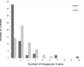
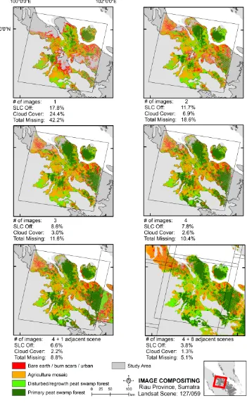
Overcoming limitations with Landsat imagery for mapping of peat swamp forests in Sundaland
Full text
Figure


Related documents
• Mission Creek between Lemos Lane and Lake Elizabeth is inadequate to convey the FEMA 100-year design peak flow • At Reach 1, the golf course floods; the existing SFPUC abandoned
(a-b) The mean velocity in the vegetated (solid lines) and non-vegetated (dashed lines) island cells for all model runs at each patch size for sparse (a) and dense (b) vegetation..
• Electrical Technical Committee of the Aluminum Association, “A Method of Stress-Strain Testing of Aluminum Conductor and ACSR” and “A Test Method for Determining the Long
We propose to ensure that our inequality measure (i) is additively decomposable (allowing the overall inequality to be broken down into two components: inequality within
Here, we present the dataset of an incubation performed with 360 intact peat cores from three different land-uses (i.e. 120 from intact peat swamp forest; 120 from drained logged
The competent authority may issue safety codes and safety standards, from time to time, prescribing the requirements for radiation installation, sealed sources, radiation
23.. The coefficient of interest in all relationships is β. Once controlling for covariates and fixed effects, this parameter captures the net effect of deviations from the
The present study explored dyadic data from 879 remarried couples and used a multiple group approach to consider whether the wife, the husband, neither, or both have children, and
