QuakeSim: Enabling Model Interactions in Solid Earth
Science Sensor Webs
Andrea Donnellan, Jay Parker, Charles Norton, Gregory Lyzenga, Margaret Glasscoe Jet Propulsion Laboratory, California Institute of Technology
4800 Oak Grove Drive Pasadena, CA 91109
818-354-4737
[email protected] Geoffrey Fox and Marlon Pierce
Community Grids Laboratory, Indiana University 501 N. Morton, Suite 224
Bloomington, IN 47404 John Rundle
Department of Physics, University of California, Davis One Shields Avenue
Davis, CA, 95616 Dennis McLeod
University of Southern California Mail Code 0781, 3651 Trousdale Parkway
Los Angeles, CA 90089 Lisa Grant
University of California, Irvine Irvine, CA 92697
Walter Brooks NASA Ames Research Center Moffett Field, California 94035
Terry Tullis
Department of Geological Sciences, Brown University Providence, RI 02912
Abstract—QuakeSim is problem-solving environment for understanding earthquake processes through the integration of multiscale models and data. The goal of QuakeSim is to substantially improve earthquake forecasts, which will ultimately lead to mitigation of damage from this natural hazard. Improved earthquake forecasting is dependent on measurement of surface deformation as well as analysis of geological and seismological data. Space-borne technologies, in the form of continuous GPS networks and InSAR satellites, are the key contributors to measuring surface deformation. We are expanding our QuakeSim Web Services environment to integrate, via Ontology-based Federation, both real-time and archival sensor data with high-performance computing applications for data mining and assimilation. We are federating sensor data sources, with a focus on InSAR and GPS data, for an improved modeling environment for forecasting earthquakes. These disparate measurements form a complex sensor web in which data must be integrated into comprehensive multi-scale models. In order to account for the complexity of
“Grid of Grids” approach, which included the development of extensive Geographical Information System-based “Data Grid” services. We are extending our earlier approach to integrate the Data Grid components with improved “Execution Grid” services that are suitable for interacting with high-end computing resources. These services are being deployed on the Columbia computer at NASA Ames and the Cosmos computer cluster at JPL.
TABLE OF CONTENTS
1. INTRODUCTION...2
2. RELEVANCE ...3
3. TECHNOLOGY...3
4. APPLICATIONS...7
5. CONCLUSIONS...9
1. I
NTRODUCTIONFor over a decade, the solid Earth science community has been analyzing data from radar satellites and preparing for a US-led Interferometric Synthetic Aperture Radar (InSAR) mission. Other spaceborne data used in modeling earthquake processes come from GPS from the 250 station Southern California Integrated GPS Network (SCIGN) and the Plate Boundary Observatory, covering a broader region of the western US. GPS data are in the form of daily position time series of surface deformation. The data can be analyzed for transient station motions from the time series, or the long-term vector motions can be used to model fault activity in southern California.
A goal of this project is to prepare for the anticipated deluge from InSAR data from the DESDynI mission recommended for near-term launch by the Decadal Survey. We also need to enable fusion and analysis of data from different sensors and sources via Ontology-based Federation. This will serve
to help develop the necessary data and modeling infrastructure for developing an improved understanding of earthquake processes.
[image:2.612.54.549.309.655.2]Use of NASA’s Columbia computer is enabling us to construct the complex and detailed models necessary for accurate understanding and forecasting of earthquakes. Columbia provides an integrated computing, visualization and data storage environment. This project will integrate spaceborne data with ground-based data and simulations using high-end computational infrastructure. The focus is to meet a practical need of contributing to the mitigation of disasters from earthquakes while developing Web Services, federation tools, and computational tools that can be applied more broadly to other scientific problems. We are addressing issues such as security, communication with supercomputers through a Web Services environment, distributed, heterogeneous data sources, and data from upcoming missions.
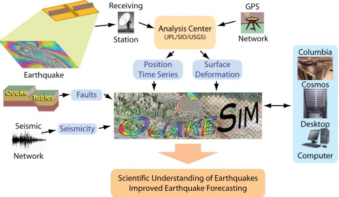
Figure 1 – Risk estimation processing showing the relation between a geophysical sensor web and earthquake risk mitigation. The sensor web is on the left column and feeds into simulation and data mining tools. These in turn flow
2. R
ELEVANCEEnabling model interactions in sensor webs should lead to improved estimates of damage probability for mitigating losses from potential earthquakes. Our sensor web data sources consist of surface deformation data from GPS and InSAR satellites and seismicity from the California Integrated Seismic Network. These are coupled to QuakeTables, the earthquake fault database service and simulation and data-mining tools (Figure 1) through execution services for application management. The high performance software GeoFEST, Virtual California, and PARK are used for simulations and the PI (Pattern Informatics) and RDAHMM (Regularized Deterministic Annealing Hidden Markov Models) methods make up the data-mining tools. Outputs of these models describe potential earthquakes. The locations of potential earthquakes, combined with attenuation models, indicating how shaking diminishes from the source of the earthquake, and local site effects are used to determine probable ground motions. These potential ground motions combined with the response of structures are used to estimate damage probability. Once this is known, strategies to mitigate the effects of earthquakes such as targeted retrofitting and disaster preparation can be more effectively developed.
3. T
ECHNOLOGY [image:3.612.60.555.54.342.2]QuakeSim focuses on ingesting data and models into simulations run on desktop workstations or on high-end computers. Such a system requires interoperable data ingestion. We are using emerging grid and web common languages and semantic metadata (specified by ontologies) to enable data exchange and fusion. QuakeSim involves data assimilation, high performance computing, semantic data modeling, and constructing Geographical Information Systems as Web Service-based Grids. The current objectives of QuakeSim are a) the extension of data assimilation and analysis applications to high performance computing platforms, b) the support for InSAR data in anticipation of future InSAR satellite missions, and c) and the deployment and integration of services for high performance computing resources with our data services infrastructure. QuakeSim provides interoperable ingestion of data as well as easy plug-and-play structure for scientific algorithms, using emerging grid and web common languages. The goal is to rapidly produce scientific understanding of earthquake processes and develop testable earthquake forecasts and forecasting methodology to be integrated into operational agencies (Figure 2).
or waveforms associated with earthquakes. We are studying and modeling the strain and fault interactions that are associated with or otherwise produce large damaging earthquakes. Surface deformation data, largely in the form of spaceborne data from GPS and InSAR, are key inputs to studying these processes. We are, therefore, focusing on ingesting InSAR data and integrating it with other data types such as GPS and paleoseismic (fault) data into models of interacting fault systems. These data sources are made available through both archival and real-time Web Services based on the Geographical Information System service specifications defined by the Open Geospatial Consortium. A Web Services management system, HPSearch, and Web Service information systems (based on UDDI and WS-Context) provide the glue that couples these data sources and the applications.
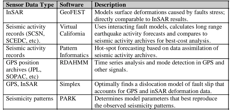
The QuakeSim web services environment currently does not support high performance computing resources, which must be used to realistically investigate the more interesting data mining and assimilation problems. Thus the two primary challenges at present are a) building upon our earlier successes in high performance computing applications by applying them to new and larger data sets, and b) integrating the high performance applications and their associated sensor data (Table 1) with our Service Oriented Architecture.
Under previous work [1] we have developed component-based portals and Web Services to support geophysical applications. Applications include traditional high performance software as well as data analysis and assimilation codes. The modeling applications include GeoFEST [2], a finite element model that simulates stresses associated with earthquake faults, Virtual California [3],
which simulates large, interacting fault systems, and PARK [4], which simulates complete earthquake cycles and earthquake interaction. Analysis methods include Pattern Informatics [5], which examines seismic archives to forecast geographic regions of future high probability for intense earthquakes, and RDAHMM [6], a time series analysis application that can be used to determine state changes in instrument signals (such as those generated by Global Positioning System arrays).
GIS Services, Sensor Webs, and Workflow
Much of our Web Service development work has focused on developing Geographical Information System (GIS) data services and integrating them with the applications listed above. We have implemented and extended a number of the Open Geospatial Consortium’s standards, including the Web Feature Service [7], a general purpose data archive, typically built on top of a relational database, and the Web Map Service, a Web Service for rendering Web Feature Service entries as human readable maps. The work si summarized at www.crisisgrid.org. An extensive technical report is available [8].
Our Web Feature Service is capable of storing archived data (such as GPS, seismic records, and fault data), but we are also integrating real-time GPS data streams with applications. Our approach is based on combining the Sensor Web Service modeling languages such as SensorML [9] with topic-based publish/subscribe middleware that can be used to route and filter live data streams. We have prototyped this using RDAHMM (Regularized Deterministic Annealing Hidden Markov Model), a statistical time series analysis code applied to seismicity and position time series data. We currently support over 7 GPS
Sensor Data Type Software
Description
InSAR GeoFEST
Models
surface
deformations
caused
by
faults
stress;
directly comparable to InSAR results.
Seismic activity
records (SCSN,
SCEDC, etc).
Virtual
California
Uses interacting fault models, calculates long range
earthquake activity forecasts and compares to
seismic activity archives for best-cost analysis.
Seismic activity
records
Pattern
Informatics
Hot-spot forecasting based on data assimilation of
seismic activity archives.
GPS position
archives (JPL,
SOPAC, etc)
RDAHMM Time series analysis and mode detection in GPS and
other signals.
GPS, InSAR
Simplex
Optimally finds a dislocation model of fault slip that
accounts for GPS and inSAR deformation data.
Seismicity patterns PARK
Determines model parameters that best reproduce
[image:4.612.79.531.503.718.2]the observed seismicity patterns.
sub-networks that contain over 70 individual stations in the Southern California Integrated GPS Network. We are interested in addressing scaling and performance issues as we increase the number of GPS stations and in combining the streaming applications with other event detection applications.
Both archival and real-time Grid applications require the integration of many different services (for data, execution, stream routing, etc.) into a complex meta-application. The management of these services is typically called workflow. We have developed a general-purpose Web Services management tool, HPSearch (www.hpsearch.org), which can manage SERVO’s Geographical Information System services, GPS data streams, and applications such as Pattern Informatics and GeoFEST [10]. In this project, we propose to extend HPSearch to support secure Web Services (such as is available from Globus) for running applications on high performance computers.
We have also developed distributed information services to support both stateless and stateful information in distributed Web Services. These are based on the UDDI and WS-Context specifications, respectively. Stateless information sources are those that respond to all queries in the same way. Stateful information depends on which client makes the query. For example, different users may be interested in receiving information about different collections of GPS stations. Matching these users to station streams is an example of a context [11].
The challenge of this project is to combine sensor data, accessible through the Data Grid Services with high performance resources to investigate challenging problems
reinvent technology but to instead rely upon third party solutions. The current version of the Globus Toolkit (Version 4) [12] has been significantly revised to make use of Web Service standards. Also, the client-programming environment for Grid portals (grid portlets [13; 14] and the Java CoG Kit [15]) has undergone significant enhancements. Globus services solve the two shortcomings in our current job management services: they have built-in job managers that translate user requests into different job scheduling systems (including PBS and others), and they have a security system that is capable of spawning jobs as specific users.
Portal Development. We continue our upgrade of the QuakeSim portal to use the JSR 168 standard. Portlets implemented include
• RDAHMM archival portlets (which include multiple site queries). These are integrated with the SOPAC GRWS GPS service.
• STFilter portlets, which can be used to analyze GPS archival data. These use plotting libraries from BFO for generating interactive plots.
• Portlets for displaying GPS real time data plots. • Initial versions of portlets for executing GeoFEST Current work is available through the IU Team’s QuakeSim Source Forge Repository.
http://crisisgrid.svn.sourceforge.net/viewvc/crisisgrid/Quake Sim2/.
Service Development. We have worked on both archival (request/response style) service access and real-time data access. The first group includes the following:
[image:5.612.85.504.62.285.2]The first two completely revise services developed in earlier version of our project. The new versions of these services are more decoupled from the portal environment and so will support integration with other projects. Collaborators in the REASoN project, for example, are using the RDAHMM service.
We have also set up a final version of our Web Feature Service, available from:
http://gf8.ucs.indiana.edu:8080/wfs/services.
We deployed an atom feed version of this service for delivering seismic data. Additional data feeds for this service are being developed.
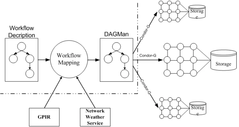
System Architecture. Our implementation of a workflow matchmaking system incorporates existing technology (Figure 3). Since the target execution environment is TeraGrid, which uses the Globus Toolkit to provide remote job submission and management, we select Condor DAG to describe and submit workflow jobs with its support by Condor-G.
We use two services to get resource information required by workflow matchmaking. Static information, e.g. CPU
number, OS, etc, is retrieved through GPIRQuery, the web service provided by GPIR. While dynamic information, such as network bandwidth, host load, etc, is acquired by NWS. Both GPIR and NWS are installed and running on TeraGrid to serve queries.
Workflow Matchmaking Algorithm. We formalize the problem of workflow matchmaking. Given the DAG (Directed Acyclic Graph) of the workflow, the set of resources, the computation costs and waiting times of jobs on all possible resources, and the communication costs between jobs on possible resources, we select the mapping from the jobs to the resources to minimize the makespan of the workflow.
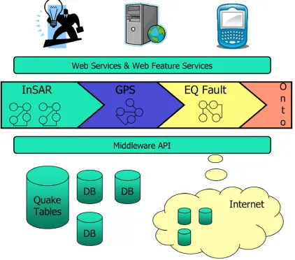
[image:6.612.100.522.48.420.2]Based on the uniqueness requirements and conditions of our target applications and execution environment, we use a resource critical heuristic for workflow matchmaking. The key idea of the heuristic is to exploit the fact that some jobs can only run on certain resources. When scheduling a job, existed heuristics only consider the schedule time of this job and previous jobs. If the later jobs can only run a few resources and are not taken into consideration at the scheduling of jobs before it, the result might be less optimal. Figure 4. The architecture of the federated ontology and its interaction with the users, QuakeTables,
Data Management
One of the key problems in the effective utilization of available data in earthquake forecasting and related research involves providing an effective interface to InSAR, GPS, and other (high-speed) streamed data. These data must be ingested and stored in a manner effective for selective sharing. In addition, these data must be inter-related with paleoseismic data, fault databases, etc. What is needed is a semantic (ontology-based) federation of these data. The functionality required is for a scientific user to be able to locate specific information they need, for example to use with their modeling or simulation systems. This interface will be an extension of our current Quakesim portal facilities. Once a scientist has found data of interest, and we employ both pull (query) and push (notify the user of things relevant to them), they may wish to visualize it at various levels of abstraction, and in many cases use high performance computing to run their programs on the selected data. This of course involves a program/data interface problem that is to be a part of our web-service based approach to interoperation. We have initiated the design of the overall framework for database sharing and interoperation we plan to employ, based upon a federation of ontologies.
One of the key issues in this project is the utilization and representation of fault data and streaming InSAR and GPS data. A federated ontology is currently being developed to semantically represent GPS data and manage its availability via real-time streaming data services. As part of the development process, multiple GPS data representations and data access services are currently being examined.
An API will be used to interface users with the data represented by the ontology (Figure 4). This API will be part of the QuakeSim portal. Scientists will be able to perform queries at different levels of abstraction and run simulations of the data obtained from QuakeSim. The communication between QuakeTables and the federated ontology will be managed through a middleware API.
4. A
PPLICATIONSVirtual California and GeoFEST
Virtual California (VC) is a numerical simulation code for the system-level dynamics of the vertical strike-slip fault configuration in California [16;17]. The majority of plate boundary deformation in California is accommodated by slip (i.e. earthquakes) on the strike-slip faults included in VC models. We have recently developed a much more detailed model having 12,288 = 3*212 elements at a scale of resolution of approximately 3 km. We have recoded in C++ and parallelized the code with an efficient MPI implementation using MPI-II. A current limitation of
strike slip faults. We are adding dipping thrust and normal faults to the existing QuakeTables fault database, and will couple Virtual California with GeoFEST to compute the necessary Green’s functions. In the latest version, VC forecasting calculations can be trained on existing seismic data archives. The 1994 Northridge earthquake on a blind thrust fault beneath the Los Angeles metropolitan region demonstrated the importance of adding these faults. Dipping faults must be included in the database to enable forecasting based on VC simulations and interpretation of hotspot maps based on processing sensor web archives of seismicity data. PARK
The PARK code [4] runs on both Columbia and the JPL cluster. It uses fast multipoles to allow the efficient use of many elements in a boundary element representation of earthquake slip using rate and state friction and radiation damping, the most accurate representation presently available of the quasi-dynamic behavior of faults. Ongoing studies using the PARK code are focused on the Richter magnitude ranges from 1.0 to 6.0 at Parkfield California, using a multi-scale grid representation. The same approach using the multipole method and a wide range of element sizes can be used on any array of fault elements on any number of faults, covering any sized area of interest – our Virtual California code is an example of a coarser scale gridding scheme covering a much larger area and using a simplified frictional representation.
PI and RI Methods
We have developed two types of hotspot maps: the original seismic Pattern Informatics (PI) map and the Relative Intensity (RI) map. Both were first discussed as possible forecast tools over a 10-year time span in [18]. In that work the original hotspot map was published February 19, 2002. During the time of the forecast (January 1, 2002 – 2010), 19 significant events with M ~ 5.0 or greater have occurred in the area of the original forecast map, with 17 of them showing a close spatial relationship to the colored hotspots. 16 of these events occurred after February 19, 2002, and 14 of those were among the group near the hotspots. More recently, we have shown [19] that it is possible to develop an ensemble classifier schema using both RI and PI (“RIPI”) that allows us to determine whether a broad geographic region (“northern” or “southern” California) is currently in a “high risk” or “low risk” state for major earthquakes having M > 6.0). We find that currently, northern California is in a high risk state, whereas southern California is in a low risk state.
RDAHMM
time series and across a network of sensors. Currently the method is applied to classification of seismicity data and position time series data from GPS. The unique modeling technology allows us to be effective even in cases in which there is no model for the observed system, as well as overcome stability problems that plague standard methods. One challenge we face is that the method needs to be computationally swift enough to be applied in real time to streaming sensor data. Current model fitting methods, including the one we outline above, are iterative approaches that can take an unacceptably long time to converge. We are solving this problem by using methods such as conjugate gradient acceleration to speed convergence. In order to take advantage of situations in which multiple computational processors are available, we are implementing our methods so that they can be run in parallel wherever possible.
Work has begun on upgrading the RDAHMM code to operate in real time. A scheme for a low-communications overhead parallel version of RDAHMM has been developed. We are now implementing a parallel RDAHMM (RDAHMMP) and carrying out performance testing to determine speedup. In conjunction we are working with IU
to develop the RDAHMM web service (Figure 5). RDAHMM has been extended to include the use of structured covariance matrices, which reduces the number of free parameters. This should therefore yield more reliable results for multiple station analysis. This functionality is not yet available through the web portal. Multiple site RDAHMM analysis is now available using the original method.
Data Fitting Techniques
[image:8.612.95.526.352.683.2]In order to develop an effective and precise algorithmic component for the coming complex sensor web, we need to integrate data and modeling software at the level where sensor observations are sensitive to model parameters. Because we intend the system to be used where processes are still uncharted, it is essential that new modeling components be straightforward to add by geophysicists. We are building a data-fitting core software module such that new data or new models may be correctly combined with prior data using all the information in each. We are doing this by using a collection of federated meta-data specifications (ontologies), and a system we have developed for accomplishing the inter-connection of heterogeneous data sources [20].
Initial progress toward this will be rapid by expanding the Simplex application of QuakeSim, to include additional physical deformation processes and data types, and to separate the core data-fitting functions from the modeling software and the data input. Included processes will include subsurface loads (aquifers, oil extraction, and volcanic inflation), additional fault models such as locking depth slip, addition of dipping faults, and partially known systematic errors. The QuakeSim environment will be enhanced for ease of problem setup and documentation for these process estimation runs. Simplex estimates slip on faults and will estimate other deformation processes. However, it is limited to homogeneous elastic models, and so we will develop a correction step, wherein the Simplex estimate of fault slip automatically becomes the basis of a suite of detailed finite element simulation including known materials variation. This suite of results will indicate the best first-order correction to the fault parameters, which is often a sufficient result. The potential for fully-iterative optimal fits to data will be evaluated.
The goal is a broadly adaptable integrated precision surface deformation monitoring system combined with a modeling system that incorporates processes at multiple scales. This will allow definition of a baseline model of regional and global deformation processes, which can be continuously compared with sensor observations for automatic early detection of unusual events.
To account for the relevant data (e.g. InSAR, GPS) necessary for the models and to constrain the simulations, we are developing a data-fitting core software module that connects in a standard way with separate modeling and observational models that incorporate realistic instrumental errors and covariance, capable of running on remote machines. The core module would be dedicated to least-squares fitting of all data and models chosen by the user, minimizing a chi-square cost function that measures the weighted deviation of the observed data to the sum of the effects of all participating modeling modules. Other kinds of computations, including registering observations in a global reference frame, atmospheric and orbital effects, and geophysical processes will be relegated to the modeling modules. The end result makes optimal use of all kinds of solid earth deformation sensors and will be extensible to observations such as gravity. It provides a framework in which various models may be steadily and systematically improved by an ongoing community effort, and various sensors can be incorporated directly. It will also lead to a slow-deformation background model that will form the baseline from which unexpected deviations can be rapidly detected and classified.
5. C
ONCLUSIONSCurrent earthquake risk estimation is based on static models inferred from past earthquake activity as determined through
of crustal deformation and rates of strain contribute to earthquake hazard assessment, largely through GPS and InSAR observations. Earthquake fault systems are continuously changing state based on deformation of the Earth’s crust and mantle as well as strain release and transfer from earthquakes. It is important to develop time-dependent models for earthquake forecasting.
QuakeSim aims to integrate both real-time and archival sensor data with high performance applications for data mining and assimilation. In order to achieve the development of complex models of interacting fault systems, models are coupled together and users access those models through a web services environment. QuakeSim integrates distributed heterogeneous data sources through federated databases, and our goal is to carry out models and simulations on high performance or appropriate computers through our grid of grids approach.
R
EFERENCES[1] Donnellan, A., J. Rundle, G. Fox, D. McLeod, L. Grant, T. Tullis, M. Pierce, J. Parker, G. Lyzenga, R. Granat, M. Glasscoe, QuakeSim and the Solid Earth Research Virtual Observatory, PAGEOPH, in press.
[2] Parker, Jay, Andrea Donnellan, Gregory Lyzenga, John B. Rundle, Terry Tullis: Performance Modeling Codes for the QuakeSim Problem Solving Environment. International Conference on Computational Science: 855-862, 2003.
[3] Rundle, J.B., K.F. Tiampo, W. Klein and J.S.S. Martins, Self-organization in leaky threshold systems: The influence of near mean field dynamics and its implications for earthquakes, neurobiology and forecasting, Proc. Nat. Acad. Sci. USA, 99, Supplement 1, 2514-2521, (2002).
[4] Tullis, T. E., Earthquake models using rate and state friction and fast multipoles, Geophysical Research Abstracts (European Geophysical Society), 5, 13211, 2003.
[5] Tiampo, K.F., Rundle, J.B., McGinnis, S., and Klein, W. Pattern dynamics and forecast methods in seismically active regions, Pure and Applied Geophysics, 159, 2002. [6] Granat, R. A., Regularized Deterministic Annealing EM
for Hidden Markov Models, Ph.D. Thesis, University of California, Los Angeles, 2004.
[8] Aktas, Mehmet, Galip Aydin, Geoffrey Fox, Harshawardhan Gadgil, Marlon Pierce and Ahmet Sayar, “SERVOGrid Technical Documentation” NASA AIST Technical Report.
[9] Botts, M (ed), OpenGIS Sensor Model Language (SensorML) Implementation Specification, OGC 05-86r2, 2006.
[10] Aydin, Galip, Mehmet S. Aktas, Geoffrey C. Fox, Harshawardhan Gadgil, Marlon Pierce, Ahmet Sayar “SERVOGrid Complexity Computational Environments (CCE) Integrated Performance Analysis.” In proceedings of GRID2005, Seattle Washington., November 12-13, 2005.
[11] Aktas, Mehmet, Geoffrey C. Fox, Marlon Pierce “An Architecture for Supporting Information in Dynamically Assembled Semantic Grids” Technical report August 2005, accepted for publications in Proceedings of Semantics, Knowledge, and Grid, Beijing, China, November 2005.
[12] Foster, I, C. Kesselman, G. Tsudik, S. Tuecke, A Security Architecture for Computational Grids. Proc. 5th ACM Conference on Computer and Communications Security Conference, pp. 83-92, 1998.
[13] Alameda, Jay, Marcus Christie, Geoffrey Fox, Joe Futrelle, Dennis Gannon, Mihael Hategan, Gopi Kandaswamy, Gregor von Laszewski, Mehmet A. Nacar, Marlon Pierce, Eric Roberts, Charles Severance, and Mary Thomas, "The Open Grid Computing Environments Collaboration: Portlets and Services for Science Gateways." Submitted to "Science Gateways" special issue of Concurrency and Computation: Practice and Experience, 2006.
[14] Nacar, Mehmet, Mehmet Aktas, Marlon Pierce, Zhenyu Lu, Gordon Erlebacher, Dan Kigelman, Evan F. Bollig, Cesar De Silva, Benny Sowell, and David A. Yuen. "VLab: Collaborative Grid Services and Portals to Support Computational Material Science" GCE'05 Workshop on Grid Computing.at SC05 Seattle, WA. November 18 2005.
[15] Amin, Kaizar, Mihael Hategan, Gregor von Laszewski, Nestor J. Zaluzec: Abstracting the Grid. PDP 2004: 250-257.
[16] Rundle, J.B., D.L. Turcotte, and W. Klein eds., Geocomplexity and the Physics of Earthquakes, Geophysical Monograph 120, American Geophysical Union, Washington, DC, 2000.
[17] Rundle, P.B., J.B. Rundle, K.F. Tiampo, J.S.S. Martins, S. McGinnis and W. Klein, Nonlinear network dynamics on earthquake fault systems, Phys. Rev. Lett., 87, 148501, 2001.
[18] Rundle, J.B., K.F. Tiampo, W. Klein and J.S.S. Martins, Self-organization in leaky threshold systems: The influence of near mean field dynamics and its implications for earthquakes, neurobiology and forecasting, Proc. Nat. Acad. Sci. USA, 99, Supplement 1, 2514-2521, 2002.
[19] Holliday, JR, JB Rundle, DL Turcotte, W Klein, KF Tiampo, and A. Donnellan, Space-time correlation and clustering of major earthquakes, Phys. Rev. Lett., in press, December 1, 2006.