City, University of London Institutional Repository
Citation
:
Slingsby, A., Longley, P. A. and Parker, C. A. (2004). Aspects of the Design of a Three-Dimensional National Mapping Data Framework. Paper presented at the GISRUK04, 28 - 30 Apr 2004, University of East Anglia, Norwich, UK.This is the unspecified version of the paper.
This version of the publication may differ from the final published
version.
Permanent repository link:
http://openaccess.city.ac.uk/567/Link to published version
:
Copyright and reuse:
City Research Online aims to make research
outputs of City, University of London available to a wider audience.
Copyright and Moral Rights remain with the author(s) and/or copyright
holders. URLs from City Research Online may be freely distributed and
linked to.
Aspects of the Design of a Three-dimensional
National Mapping Data Framework
A. D. Slingsby
1, P. A. Longley
1and C. Parker
21Centre for Advanced Spatial
Analysis,
University College London, 1-19 Torrington Place,
London, WC1E 7HB
2Research & Innovation,
Ordnance Survey, Romsey Road, Southampton, SO16 4GU
1. Introduction
This paper reports on the progress of a project co-sponsored by Ordnance Survey (GB) and ESRC, on the specification of the practical 3D data requirements for national mapping. The objective is to design and implement a framework for the three-dimensional representation of the built-environment, in the context of national mapping. Spaces within and outside
buildings will both be held in the same framework, allowing the seamless treatment of these spaces. An important aspect of the framework will be an appropriate ontology (conceptual model) of the built-environment – specifically of how buildings are defined and how they can be divided into smaller units corresponding to elements such as storeys, flats and rooms. The challenges of 3D mapping also include the need to understand and represent pedestrian access to and within the built-environment. Taken together, these needs suggest the following three priorities that are being considered in the design of a prototype database system, from which various views (maps) can be generated:
• the ability to divide built-forms into constituent sets of discrete units using flexible but robust criteria, and the facility to attach unique identifiers and attributes to them;
• the ability to treat the interior spaces of buildings in the same way as spaces outside
buildings in a seamless fashion, e.g. allowing a courtyard space to be retrieved in the same way as an entrance lobby space;
• the ability to resolve customised pedestrian access and pedestrian routes to and within
buildings according to the type of pedestrian (e.g. security staff, employee, visitor, individuals with impaired mobility).
The paper begins with a review of the UK’s existing digital national mapping product (OS MasterMap®). Some of the experiences and solutions of the Non-Domestic Building Stock Project (a research programme based at the Bartlett School of Graduate Studies at University College London) are used to illustrate the importance of these issues.
2. National Mapping
Ordnance Survey is Britain’s national mapping agency and its products are being used in a number of case studies. OS MasterMap is Ordnance Survey’s most recent large-scale digital mapping product. It is organised into themed ‘layers’.
The ‘Topographical Layer’ contains geometry in the form of point, line and polygon
‘features’. Point features are used to indicate spot heights and small topographic features (e.g. telephone boxes, mooring posts and individual trees); line features indicate physical
which persists throughout its lifetime and is never reallocated. As indicated above, certain OS MasterMap features (indexed and referenced to by TOIDs) correspond to ‘real-world’
features and as such present a ‘feature-based’ approach to digital mapping. However many concepts of ‘real-world’ features are composites or are composed of fragments of OS MasterMap features; OS MasterMap has no concept of higher-level features which reflect this. Other OS MasterMap features just correspond to pieces of geometry, which cannot be conceptualised as tangible geographical features.
Two other layers relevant to the project are the ‘Integrated Transport Network Layer’ (a set of nodes and links which form a fully connected road and path network including access
restrictions) and the ‘Address Layer’ (a set of points corresponding to individual Royal Mail postal delivery points).
Two of the most important characteristics of national mapping products are that the data are held in a standard format over the whole country and that the data can be used by the widest range of organisations possible for numerous possible uses. Retention of these guiding principles is central to this project, in order to make it of close relevance to the national mapping agenda.
3. Representation of Built-Form
3.1. Discrete units in built-form
The term ‘built-form’ is used here, because buildings imply discrete units. Currently, national mapping products provide discrete building data – i.e. built-form as a set of non-overlapping discrete units. The common problem with this is that they may not correspond to the built-form units of other agencies. For example the taxable units of built-built-form used by the
Valuation Office (VO) are smaller than the building footprints provided by national mapping agencies. For this reason, the VO and similar agencies have to hold and maintain their own data on built-form. The problem is more marked in 3D because of the juxtaposition of units in multilayered environment. The Non-Domestic Building Stock (NDBS) Project (Steadman et al 2000) which used data from the Valuation Office is an example of a study which had to address this problem.
A theoretical solution would be to treat and store built-form as continuous space, allowing it to be divided into discrete units when needed using relevant criteria. In a practical sense, this is not possible. Even if it were, a mechanism similar to a TOID would need to be found. The more practical solution which this project is implementing is to store a large number of small ‘atomic’ units of built-form corresponding to perhaps rooms, groups of room or storeys, depending on the data availability.
We distinguish between ‘non-derivable features’ and ‘derivable features’. Non-derivable features are those which cannot be derived from the model. For example there are no reliable rules for which elements comprise a legal ownership unit of the built environment. Non-derivable features will need a list of all the geometrical features which comprise it. Derivable features are those which we are able to automatically identify from our model. From the geometrical and topological description within our model, we will show how we can delineate and aggregate the various elements in different ways to form larger features according to robust criteria. In effect, derivable features will be dynamic database queries from a starting point.
3.2. Within built-form
representation of ‘interior space’ by non-standard floor-plan based representations or 3D models reduces the ability to directly compare features and spaces over large geographical areas. It is for this reason that our framework treats interior and exterior space in the same way. If this principle were applied to OS MasterMap, polygons of the ‘Topographic Layer’ would represent both exterior land parcels (fields, pavements and pathways) and interior rooms, ramps and corridors. Attributes and rules will be used to discern whether these polygons are bound by walls and if they are covered.
Since data for the interiors of buildings are often difficult to obtain and since it is
inappropriate for buildings such as residential houses to have their interiors mapped, atomic units (see previous section) may vary in extent to those of rooms or storeys. The ability to cope with different levels of detail in the built environment is important for these reasons.
3.3. Access
Buildings are designed for human use, so a model of the built environment should be sensitive to the ways in which they are used by people. Currently OS MasterMap has no information about pedestrian access, but it does have information on road access. We will illustrate how customised pedestrian networks of access for pedestrians with different access rights and mobility needs can be derived from the model, rather than having to store a network
separately. The seamless treatment of space will facilitate the generation of routes around and through buildings. For example, inner city shopping centres present important thoroughfares to different parts of a city.
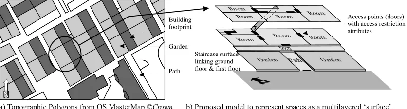
Integral to our proposed model will be pedestrian accessibility. The initial aim of our model is to represent all spaces which are accessible by pedestrians in the form of a series of surfaces which are all linked to surfaces at other levels by links corresponding to those of pedestrian access, namely staircases and lifts (see figure 1).
Criteria for defining the ‘derivable features’ of built form may be based on access, among other factors. For example a criterion for delineating a ‘house’ could be all the spaces from the main door accessible by those with the access rights of the main door. In blocks of flats, the corridor and stairwell is accessible by those with the access rights of the main door, but individual flats are only accessible by those with the access rights to the flat’s main door. Another example of space aggregation by accessibility is the delineation all of all spaces with public wheelchair access in a town centre (including shop interiors). These aggregations could also be time-dependent, for example the number of spaces with public access in a town centre usually diminishes at night.
3.4. Geometrical description
The NDBS model used polygons to represent a room, group of rooms or storey and these are stacked according to storey separations (Holtier et al, 2000). Attributes corresponding to rooms can be attached to floor polygons and scripts were used to produce all the information needed for the study and could aggregate floor polygons into larger ones. The major study
Building footprint
Garden
Path
a) Topographic Polygons from OS MasterMap.©Crown b) Proposed model to represent spaces as a multilayered ‘surface’.
Access points (doors) with access restriction attributes
[image:4.595.91.509.74.186.2]Staircase surface linking ground floor & first floor
was the energy efficiency of buildings. Relevant derived information included the area of exposed wall and the roof area.
Our geometrical description has been inspired by the success of the NDBS model for the representation of the built-environment and the inference of its characteristics. As stated above, we are interested in its storage in a topologically consistent form, with our initial aim to represent the built-environment as a series of accessible surfaces linked according to permanent pedestrian vertical links. This initial aim relies on 2D geometry and topology rather than full 3D geometry. 3D models will be able to be derived through the use of anchor points and attributes on the geometry indicating whether it is to be absolutely horizontal, almost horizontal or inclined. 3D geometry will be derived from a search through connected elements and the evaluation of spot heights (see figure 2), and each height could be given an error margin based on the distances of the spot heights used. The reason we are taking this approach rather than full 3D geometrical modelling is that it is more concise and there is a lot of uncertainty in the geometry of geographical data, especially along the z axis. This model recognises the need to use the available data to resolve a best estimate. Where more data becomes available, it can be added and used when the 3D geometry is next derived. However the connectivity of pedestrian accessibility is given priority.
Edges of polygons will be able to hold attributes. Edges would indicate the nature of the interface with the adjacent polygon, for example whether there is a small vertical offset, whether there is a wall and if so, the nature of the wall. This information is relevant for access, but it can also be used to indicate the nature of the space and in the building of 3D models.
4. Implementation
The prototype database system is being built using a custom-built Java application and an object-oriented database. ESRI ArcGIS® 8 is used for the preparation of the data through the
use of VBA scripts; specifically as an editor and to built 2D topology. The data is then exported to the Java application, which will connect up the vertical topological links between surfaces. Data have been supplied by Ordnance Survey and architectural firms.
5. Consolidation
This project uses concepts of a national digital mapping product (OS MasterMap), current practices in 3D and the needs and solutions of the NDBS project in order to specify the characteristics that a 3D digital national map product should have. These characteristics are: a) the ability to divide built-forms into constituent sets of discrete units using flexible but robust criteria; b) the ability to treat the interior spaces of buildings in the same way as spaces outside buildings in a seamless fashion; and c) the ability to resolve customised pedestrian
12m 12m
11.5m 11.5m
18.5m 18.5m
‘Almost horizontal’ Inclined
Topologically connected set of polygons
z
x
y
[image:5.595.180.412.574.725.2]routes to and within buildings according to the type of pedestrian. The paper concludes with a discussion of the ways in which a 3D digital national map with these characteristics will be valuable for a wide range of GIS projects in academia and practice. Preliminary results will be presented.
6. Acknowledgements
This project is a CASE studentship funded by ESRC and Ordnance Survey. Special thanks to Harry Bruhns, David Capstick, Glen Hart and David Holland.
References
Holtier, S., Steadman, J. P. and Smith, M. G. (2000). Three-dimensional representation of urban built form in a GIS, Environment and Planning B: Planning and Design 27 pp. 51-72.
Steadman, P., Bruhns, H. and Rickaby, P. A. (2000). An introduction to the national Non-Domestic Building Stock database, Environment and Planning B: Planning and Design 27 pp. 3-10.
Biography