REGIONAL GEOCHEMICAL
DISPERSION OF ELEMENTS IN
THE
REGOLITH OF THE
GIRILAMBONE REGION,
CENTRAL WEST NSW
By
KAMAL KHIDER
A thesis submitted to the Australian National University in fulfilment
of the requirements for the degree of Doctor of Philosophy
ABSTRACT
Geochemical exploration has provided a major contribution to the discovery of mineral deposits in the Cobar-Girilambone region. The areas of bedrock exposure have generally been well explored and further discoveries will significantly depend on a better understanding of element dispersion, movement and accumulation within the
extensive areas of in situ and transported regolith cover.
This study evaluates the background levels of target and pathfinder elements in
various sampling media including groundwater, the top metre, transported and in situ
regolith; and the influences of secondary enrichment (calcrete, iron and manganese) on the element association in the regolith of the Girilambone region. It also demonstrated that the bedrock geology could be identified by geochemical signatures
preserved in in situe regolith. This improved knowledge of the regolith geochemistry
and parent bedrock will assist mineral exploration in the region.
Thresholds and anomalies for key target and pathfinder elements (As, Au, Co, Cr, Cu, Mo, Ni, Pb, Sb, V, W, Zn) are estimated using Boxplot and MAD methods. The highest threshold, which possibly indicates a local background, is indicated by the Boxplot method, whereas the MAD method indicates a lower regional background for
elements. The thresholds of Au, Cu, Pb and Zn are higher in the in situ regolith facies.
Arsenic, Cr and V show higher backgrounds when associated with enrichments of hematite and goethite in the Fe-enriched regolith zone. Four major element associations are recognized by cluster analysis. These include elements associated with Ca and Mg (carbonate group), with MnO (manganese oxide), with Fe20:, (iron oxide) and with Ni and Cr (mafic group). Principal component analysis indicates similar groups representing calcretization (Ca+Mg), adsorption (Fe-Mn oxides) and bedrock influences.
A groundwater aquifer is present within the in situ regolith in phyllitic siltstone-
Na, Cl and SO4 compared to less common calcium-bicarbonate and bicarbonate- chloride types. The correlation between Br/Cl and Na/Cl shows three processes affect the groundwater composition: evaporation, water-rock interaction and water mixing.
Calculation of groundwater ages based on l6Cl/Cl indicates that the groundwater in
the Byrock area (418000-516000 years) is older than that in the Hermidale area (241000-492000 years). Calculated saturation indices of ZnSiC^ malachite and tenorite appear to show a vector towards sites of known mineralisation. The correlation between the groundwater and regolith composition suggests at least two sites (drill holes CBAC217 and CBAC219) of potential mineralisation in the Byrock area.
Slightly weathered and deeply weathered saprolith can be discriminated using the
Chemical Index of Alteration (CIA) and major element trends (AI2O3- (Na20+CaO)-
K2O). These trends also indicate the chemical history of regolith profiles in the
Girilambone region. Four zones of weathering are recognised based on the CIA value ranging from zone I (CIA>85), zone II (75>CIA> 85), zone III (55>CIA<75) and zone IV (CIA<55).
Immobile element ratios Zr/Sc versus Th/Sc indicate the level of sediment recycling. A significant increase of Zr/Sc (>10) with insignificant or no increase in Th/Sc (~1.0), suggests significant recycling of much of the material through weathering processes.
ACC^/SiCF and TiCF/Zr ratios are used in association with the 1 5Al20 3-3 0 0Ti0 2-Zr
diagram to discriminate between sandstone, shale and mafic to felsic igneous composition. Ti/Th and Ce/La ratios are used to discriminate between saprolith materials that are derived from the Cobar Supergroup and Girilambone Group. Cobar Supergroup data are clustered in limited ranges of Ti/Th (0.039 > Ti/Th > 0.03) and Ce/La (2.2> Ce/La > 1.9) ratios, whereas those related to the Girilambone group are characterised by a relatively small range of Ti/Th (0.03 > Ti/Th > 0.005) and Ce/La (2.3 > Ce/La > 1.8).
Calcrete, Fe-Mn oxides or oxyhydroxides appear to be the major regolith components
that host Au and base metals (Cu, Zn, Pb) in transported and in situ regolith in the
Girilambone region. The association of Au with calcrete in the region appears to
conducive to precipitation of both carbonate and mobilised gold, rather than a direct control on gold fixation by calcrete. Sampling the upper part of the calcrete zone within shallow transported and in situ regolith during air-core drilling, as part of the strategy for gold exploration in this region, is recommended.
A Mn-enriched zone is variably distributed in the regolith of the Girilambone region and is concentrated in the in situ regolith. The highest MnO contents are in the southwest of the Hermidale area and generally decrease toward the east. A stratified concentration of Mn above the present water table along the groundwater flow path indicates previous water levels where the manganese oxides were precipitated due to redox changes.
Enrichments of Au (> 0.009 ppm) and As (>40 ppm) match Fe2Ü3 increases related to
the abundance of ferruginous clasts in the Fe-enriched zone, and these indicate a mechanical dispersion of remnant primary Au in ferruginous regolith.
An association of elevated Fe, Zn, Cu and Pb is correlated with the presence of weathered mafic rocks in the region. Over most of the area there is no systematic correlation of elevated Au, As, Zn, Cu and Pb with Fe2Ü3 in either the transported or
Certificate of authorship
All results, interpretations and arguments presented in this thesis are my own, except where acknowledged.
ACKNOWLEDGMENTS
This work was supported by the Australian Government’s Cooperative Research Centre Program, within CRC LEME through a CRCLEME postgraduate award and access to CRCLEME project funding.
Special thanks to my supervisors Ken McQueen and Bear McPhail who were always there for me, advising and discussing outcomes, returning chapter drafts with
insightful comments “ How, Why...and Refs. !!” with an optimistic “onward”. They are the best supervisors that the “luckiest’ PhD student could ever have.
I could not mention supervisors without thanking Keith Scott (CSIRO, North Ryde) for his periodic discussions and constructive suggestions and Professor Graham Taylor (University of Canberra) for his judgment and discussion in the early stages of the study.
The drilling for this study was carried out by the NSW Department of Primary Industries, as part of a collaborative project with CRC LEME. Most of the regolith samples were collected by CRC LEME and NSW DPI staff as part of the Girilambone project.
Rainwater data for the study area were provided by Patrice de Caritat (Geoscience Australia) whose support is gratefully acknowledged. Five groundwater samples (Hermidale area) were collected by K. McQueen.
Thanks to Professor Keith Fifield (Department of Nuclear Physics, ANU) for his assistance in analysing chlorine- 36 samples.
I thank Rushdy Othman (University of NSW) and my co-workers from CRC LEME, Roslyn Chan, Ian Roach and Tan Kok Piang for their various assistance and
discussions.
Thanks to John Spring and Aleksandra Plazinska (Bureau of Rural Sciences) for providing valuable field and laboratory assistance.
Table of Contents
Abstract
i
Certificate of authorship
iv
Acknowledgements
v
1. Chapter one: Introduction
1
1.1 Preamble 1
1.2Aims and approaches of the study 3
1.3 Thesis outline 4
2. Chapter two: Regional and site characteristics
6
2.1 Location of study area 6
2.2 Climate, vegetation and landuse 7
2.3 Regolith landforms 8
2.4 Previous work on the geochemistry and regolith in the
Girilambone region 10
3. Chapter three: Regional geology and mineralisation
143.1 Regional setting of southeastern Australia 14
3.2 Regional tectonic history 17
3.3 Local stratigraphy and intrusions 21
3.3.1 Introduction 21
3.3.2 Girilambone Group 21
3.3.3 Ultramafic and related rocks 23
3.3.4 Silurian volcano- sedimentary sequence 24
3.3.5 Cobar Supergroup and related intrusives 24
3.4 Economic geology and known styles of mineralisation 25
3.4.1 Deposits related to the Girilambone Group 25
3.4.1.1 Girilambone 26
3.4.1.2 Tritton 26
3.4.2 Deposits related to the Cobar Supergroup 27
3.5.1 Deposits associated with the Girilambone Group 28
3.5.1.1 Budgery mine 30
3.5.1.2 Bylong 30
3.5.1.3 Calcite crystal rise, North Pole prospect and
Chert Ridge prospect 30
3.5.1.4 Mount Dijon - Bald Hills 32
3.5.2 Deposits related to Silurian granitoids 32
3.5.2.1 Beanbah prospect 32
3.5.3 Deposits in unnamed Silurian volcano-sedimentary sequences 32
3.5.4 Deposits in the Cobar Supergroup 34
3.5.4.1 Glengarry gossan and related deposits 35
4. Chapter four: Sampling methodology
365. Chapter five: Data analysis techniques
395.1 Introduction 39
5.2 Exploratory Data Analysis 40
5.3 Recognition of outliers by boxplot 41
5.4 Transformations 43
5.5 Transformation to avoid closure 43
5.6 Quality control of data 44
5.7 Detection limit 49
5.8 Cluster Analysis 50
5.8.1 Amalgamation or linkage rules 51
5.8.2 Distance measures 52
5.9 Principal Component Analysis 53
5.10 Summary and conclusions 53
6. Chapter six: Geochemical background, anomalies
and element associations
556.1 Definitions and methodology 55
6.1.1 Introduction 55
6.1.3 Techniques used to determine the background and anomaly 56
6.1.4 Evaluation of the statistical techniques 56
6.2 Regolith units and geochemical backgrounds, thresholds and anomalies 58
6.2.1 Introduction 58
6.2.2 Background and threshold values 60
6.2.2.1 Element thresholds for the top meter 60
6.2.2.2 Element thresholds for the transported regolith 61
6.2.2.3 Element thresholds for the in situ regolith 62
6.3 Geochemical anomalies 63
6.3.1 Anomalies in the top metre 63
6.3.1.1 Anomalies in the clay-silt- gravel facies 63
6.3.1.2 Anomalies in the regolith carbonate facies 64
6.3.2 Anomalies in transported regolith 64
6.3.2.1 Anomalies in the clay-silt-gravel facies 64
6.3.2.2 Anomalies in the regolith carbonate facies 71
6.3.2.3 Anomalies in the iron- rich facies 71
6.3.3 Anomalies in the in situ regolith 71
6.3.3.1 Clay-silt-gravel facies 71
6.3.3.2 Anomalies in the regolith carbonate facies 76
6.3.3.3 Anomalies of the iron-rich regolith facies 76
6.33.4 Anomalies in the manganese-rich facies 76
6.4 Element associations 80
6.5 Summary and conclusions 87
7. Chapter seven: Groundwater chemistry and hydrogeology
897.1 Introduction 89
7.2 Site descriptions 89
7.3 Hydrogeology 93
7.4 Electrical conductivity, pH/Eh and temperature 94
7.5 Alkalinity 97
7.9 Identification of aquifer minerals 107
7.9.1 Weathering of silicate minerals 109
7.9.2 Saturation indices 111
7.10 Implications for exploration 112
7.11 Summary and conclusions 117
8. Chapter eight: Weathering processes and provenance
1188.1 Introduction 118
8.2 Geochemical approaches to evaluate sedimentary processes 119
8.2.1 Testing element immobility 120
8.2.2 Weathering and Chemical Index of Alteration (CIA) 121
8.2.3 Metasomatism 127
8.2.4 Sedimentary recycling 128
8.2.5 Sedimentary sorting 128
8.3 Bedrock, weathering profiles and sediment compositions 132
8.3.1 Weathering zones 132
8.3.2 Bedrock identification 134
8.4 Summary and conclusions 138
9. Chapter nine: Element dispersion in calcrete- manganese
- iron-dominant regolith
140
9.1 Introduction 140
9.2 Element associations and dispersion in regolith carbonate zones 141
9.2.1 Introduction 141
9.2.2 Nature and regional distribution of regolith carbonate 141
9.2.3 Calcrete composition 145
9.2.4. Gold concentration in calcrete 154
9.2.4.1 Association of Au with calcrete in the in situ regolith 156
9.2.4.2 Association of Au with calcrete in the transported regolith 158 9.2.5 Minor and trace element characteristics of regolith
carbonate zones 160
9.2.5.1 Silver, arsenic, bismuth, antimony and tungsten 160
9.2.5.3 Other trace elements 165
9.2.6 Origin of carbonate 165
9.2.7 Summary and conclusions 166
9.3 Element associations and dispersion in Mn-rich regolith 166
9.3.1 Introduction 166
9.3.2 Occurrence of Mn-rich horizons 167
9.3.3 Manganese oxide/oxyhydroxide minerals 167
9.3.4 Accumulation of manganese oxides and oxyhydroxides 176
9.3.5 Major and trace elements characteristics of manganese
oxides/oxyhydroxides 177
9.3.5.1 Gold concentration in Mn-rich regolith 178
9.3.5.2 Minor and trace element characteristics 185
9.3.6 Groundwater and Mn-rich regolith 188
9.3.7 Summary and conclusions 193
9.4 Element association and dispersion in Fe-enriched regolith 193
9.4.1 Introduction 193
9.4.2 Iron oxide/oxyhydroxide minerals 194
9.4.3 Trace element characteristics of Fe-enriched regolith 198
9.4.3.1 Gold in Fe-enriched regolith 198
9.4.3.2 Zinc, copper and lead associated with
Fe oxides/ oxyhydroxides 201
9.4.4 Summary and conclusions 207
10. Chapter ten: Conclusions and recommendations
20810.1 Anomaly, background and element associations 209
10.2 Groundwater chemistry and hydrogeology 209
10.3 Sedimentary weathering processes and source composition 210
10.4 Element dispersion in calcrete- manganese- iron -dominant regolith 211
10.5 Recommendations for further work 212
LIST OF FIGURES
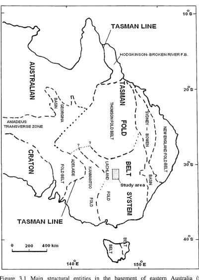
Figure 2.1 Location map of study area in western NSW. 6 Figure 2.2 Monthly rainfalls in the Cobar area. 7 Figure 2.3 Basic regolith landforms on the Girilambone region. 9 Figure 3.1 Main structural entities in the basement of eastern Australia. 15 Figure 3.2 Provinces of the Lachlan Fold Belt. 16 Figure 3.3 Elements of the early Palaeozoic geology of the Lachlan Fold Belt. 17 Figure 3.4 Cambrian to Middle Devonian development of the Lachlan Fold Belt. 19 Figure 3.5 Interpretive geological map of study area. 22 Figure 3.6 Location map showing drill hole and mineralisation sites in the
Sussex area. 29
Figure 3.7 location map showing drill holes and mineralisation sites in the
Hermidale area. 31
Figure 3.8 Location map showing drill holes and mineralisation sites in the
Byrock area. 33
Figure 5.1 An example of boxplot application. 42 Figure 5.2 Plots showing results of replicate analysis. 48 Figure 5.3 Correlation between duplicate and original element. 49 Figure 6.1. Summary profiles of thickness of transported and in situ regolith
in the Byrock (A), Sussex (B) and Hermidale (C) areas. 59 Figure 6.2. Distribution pattern of Au anomalies. 64 Figure 6.3. Distribution pattern of Co anomalies. 65 Figure 6.4. Distribution pattern of Cr anomalies. 65 Figure 6.5. Distribution pattern of Cu anomalies. 66 Figure 6.6. Distribution pattern of Mo anomalies. 66 Figure 6.7. Distribution pattern of Ni anomalies. 67 Figure 6.8. Distribution pattern of Pb anomalies. 67 Figure 6.9. Distribution pattern of Sb anomalies. 68 Figure 6.10. Distribution pattern of V anomalies. 68 Figure 6.11. Distribution pattern of W anomalies. 69 Figure 6.12. Distribution pattern of Zn anomalies. 69 Figure 6.13. Anomalies in Cr and Mo for the regolith carbonate facies in the top
Figure 6.14. Anomalies in the regolith carbonate facies of the
transported regolith. 74
Figure 6.15. Anomalies in the Fe-rich facies of the transported regolith. 75
Figure 6.16. Anomalies in the in situ clay-silt- gravel facies. 77 Figure 6.17. Anomalies in the regolith carbonate facies of the in situ regolith 78 Figure 6.18. Anomalies in the Fe-rich facies of the in situ regolith. 79 Figure 6.19. Anomalies in the in situ Mn- rich facies. 81 Figure 6.20. Elements cluster dendrograms of the clay-silt-gravel facies of
the top metre regolith unit. 82 Figure 6.21. Elements cluster dendrograms of the in situ regolith unit 82 Figure 7.1. Geologic map of the Girilambone region showing some known
mineralisation sites, drill hole locations 90 Figure 7.2 Digital elevation model of the Byrock area. 91 Figure 7.3 Digital elevation model of the Flermidale area. 92 Figure 7.4 Magnetics imagery of the Byrock area. 92 Figure 7.5 Magnetics imagery of the Flermidale area. 93 Figure 7.6 Lithologic cross-section along the groundwater flow between and
CBAC217 and CBAC227. 94
Figure 7.7 Lithologic cross-section showing the water in the northern
part of the Flermidale area. 95 Figure 7.8 Lithologic cross-section showing the water table in the southern
part of Hermidale area. 95
Figure 7.9 General hydraulic contours (m) in the Byrock area. 96 Figure 7.10 General hydraulic contours (m) in the Hermidale area. 96
Figure 7.11 Eh-pH diagram. 98
Figure 7.20 36C1 /Cl versus chloride for the Hermidale groundwater samples. 109 Figure 7.21 Hermidale and Byrock groundwater plotted on apportion
of the log (a K+/H+) versus log a Mg++/H+*2 diagram. 110 Figure 7.22 Calculated saturation indices of ZnSiOß (A), malachite (B),
and tenorite (C) in Hermidale groundwaters. 112 Figure 7.23 The Hermidale and Byrock groundwater compositions,
mineral stability fields. 114
Figure 7.24 The distribution pattern of Cu and Zn in the groundwater. 115 Figure 7.25 Distribution profiles of Cu and Zn in the regolith of the
Byrock drill holes CBAC217, CBAC219 and CBAC248. 115 Figure 7.26 Distribution patterns of EC, S 0 42-, CF, Cu and Zn in groundwater. 116 Figure 8.1 Scattergrams showing correlations between likely immobile elements. 122 Figure 8.2 Scattergrams showing immobility test correlations. 123 Figure 8.3. Scattergram showing correlation between AI2O3 and high CaO
of base of the hole saprolith samples. 124 Figure 8.4. Ternary plots of molecular proportions of AI2O3- (Na20+Ca0*)
-K2O with the Chemical Index of Alteration (CIA). 126 Figure 8.5 Plot of Th/Sc verse Zr/Sc for saprolith sample. 129 Figure 8.6 AHC^/SiC^ -100TiO2/Zr diagram for saprolith samples. 130 Figure 8.7 Ternary plot of 15Al203-300Ti02-Zr. 131 Figure 8.8 An idealized weathering profile developed on granitic bedrock. 133 Figure 8.9 A-CN-K diagram shows the weathering zones. 134 Figure 8.10 Scattergram of 30TiO2/Al2Ü3 and Ce. 136 Figure 8.11 Scattergram of SOTiCVAFC^ and La. 137 Figure 8.12 Ti/Th - Ce/La diagram of saprolith materials. 137 Figure 8.13 CIA - (Ce/La)N diagram of saprolith materials. 138 Figure 9.1 Classification of calcrete by hydrological setting. 143 Figure 9.2 Distribution of calcrete and associated soils in Australia. 144 Figure 9.3 Examples of calcrete from the Girilambone region. 146 Figure 9.4 Drill hole plots showing distribution of calcrete-bearing
zones in the transported regolith of the Byrock area. 147 Figure 9.5 Drill hole plots showing distribution of calcrete-bearing
Figure 9.6 Drill hole plots showing distribution of calcrete-bearing
zones in the transported regolith of the Sussex area. 149 Figure 9.7 Drill hole plots showing distribution of calcrete-bearing zones
in the in situ regolith of the Byrock area. 150 Figure 9.8 Drill hole plots showing distribution of calcrete-bearing zones
in the in situ regolith of the Hermidale area. 151 Figure 9.9 Drill hole plots showing distribution of calcrete-bearing zones
in the in situ regolith of the Sussex area. 152 Figure 9.10 Triangular (MgO-CaO-AbC^) compositional diagram of
the transported and in-situ regolith. 153 Figure 9.11 Bivariate MgO-CaO diagram of the transported calcrete-bearing
Regolith. 153
Figure 9.12 Bivariate MgO-CaO diagram of the in situ calcrete-bearing. 154 Figure 9.13 Scattergrams of major components in the regolith carbonate zones. 155 Figure 9.14 Distributions of Au, Bi, CaO, MgO and total Fe2Ü3 (wt %)
within in situ regolith in drill hole CBAC2. 156 Figure 9.15 Distributions of Au, W, CaO, MgO and Fe203 (total)
in drill hole CBAC188. 157
Figure 9.16 Distributions of Au, CaO, MgO and Fe203 (total)
within in situ regolith in drill hole CBAC41. 158 Figure 9.17 Distributions of Au (ppm), CaO, MgO and total Fe203 (wt %)
within in situ regolith in drill hole CBAC204. 158 Figure 9.18 Distribution of Au (ppm), CaO, MgO and total Fe203 (wt %)
within transported regolith in drill holes CBAC78 and CBAC159. 159 Figure 9.19 Scattergrams showing correlation of detectable Ag with
major elements. 160
Figure 9.20 Distribution profile showing the relationships between FC203, MnO, MgO, CaO (wt %), Ag, As, Au and Mo (ppm)
in drill holeCBAC188. 161
Figure 9.23 Showing distributions of Sr ppm, Ba ppm, S wt %, CaO wt %
and MgO wt % in drill hole CBAC213. 165 Figure 9.24 Drill hole plots showing distribution of Mn-enriched zones in
the in situ regolith. 168
Figure 9.25 SEM photomicrograph showing large flakes of mica
(muscovite) and microcrystalline Mn oxides (cryptomelane). 170 Figure 9.26 EDXA spectra showing the chemical compositions. 171 Figure 9.27 SEM photomicrograph showing a quartz crystal and
microcrystalline Mn oxides. 172 Figure 9.28 EDXA spectrum showing the chemical compositions. 172 Figure 9.29 SEM photomicrograph showing microcrystalline Mn oxides
clustered between clay crystals. 173 Figure 9.30 EDXA spectrum showing the chemical compositions. 173 Figure 9.31 SEM photomicrograph showing well-developed Mn(lithiophorite)
crystals forming sheaves in voids, mica crystals. 174 Figure 9.32 EDXA spectrum showing the chemical compositions. 175 Figure 8.33 EDXA spectrum showing the chemical compositions of
microcrystalline Mn oxides (pyrolusite). 175 Figure 9.34 Mineral sequences in the weathering of Mn-bearing silicates. 176 Figure 9.35 Distribution profile of Mn (wt %) and Mn-minerals in
drill holes CBAC176, CBAC177 and CBAC180. 178 Figure 9.36 Scattergrams of major elements in the Mn-dominant regolith. 179 Figure 9.37 Scattergrams of trace elements in the Mn-enriched regolith. 180 Figure 9.38 Distribution profiles in the Mn-dominant horizon of CBAC119. 182 Figure 9.39 Distribution profiles in the Mn-dominant horizon of CBAC191. 182 Figure 9.40 Distribution profiles in the Mn-dominant horizon of CBAC195. 183 Figure 9.41 Distribution profiles in the Mn-dominant horizon of CBAC198. 183 Figure 9.42 Distribution profiles in the Mn-dominant horizon of CBAC201. 184 Figure 9.43 Distribution profiles in the Mn-dominant horizon of CBAC211. 185 Figure 9.44 Scattergrams showing the correlation between Mn and Ba, Co, Cr,
Pb, Ni and Zn. 187
Figure 9.45 Distribution patterns in the Mn-dominant regolith of CBAC122,
Figure 9.46 A cross section showing the Mn-rich zone and watertable along
the flow path of the groundwater. 190 Figure 9.47 Distribution patterns in the Mn-rich regolith of CBAC 173. 191 Figure 9.48 Distribution patterns in the Mn-rich regolith of CBAC181. 191 Figure 9.49 Distribution patterns in the Mn-rich regolith of CB AC 185. 192 Figure 9.50 Distribution patterns in the Mn-rich regolith of CB AC 182. 192 Figure 9.51 Plan showing the location of drill holes with observed Fe-enriched
zones in the regolith from the Sussex area. 195 Figure 9.52 Plan showing the location of drill holes with observed Fe-enriched
zones in the regolith from the Hermidale area. 196 Figure 9.53 Plan showing the location of drill holes with observed Fe-enriched
LIST OF TABLES
Table 5.1. Standard deviation (s), mean (Y), coefficient of variation (CV) and precision (P) of five replicate samples from
CBAC150, Hermidale area. 47
Table 5.2 Types of distance measures. 52
Table 6.1. Threshold values of elements estimated by Median+2MAD and Boxplot methods for clay-silt-gravel, regolith carbonate,
Fe-rich and Mn-rich facies of the top metre, transported and
in situ regolith units in the Girilambone region. 62
Table 6.2 Anomalies of As, Au. Co, Cr, Cu, Ni, Pb, V, and Zn from the transported clay-silt-gravel facies of the Sussex and
Hermidale areas. 72
Table 6.3 Anomalies of Co, Cr, Mo, Ni, Pb and V from the transported
clay-silt-gravel facies of the Byrock area. 73
Table 6.4 The rotated factor matrices with loading of elements on each
component of the principle component analysis. 84
Table 6.5 The rotated factor matrices with loading of elements on each
component of the principle component analysis. 85
Table 6.6 Elemental groups as are suggested by cluster analysis (CA) and principal component analyses (PCA) from the top metre,
transported and in situ regolith facies. 86
Table 7.1 Sample depth, Electrical conductivity (EC), pH, Eh, temperature and alkalinity of the groundwater samples from the Byrock and
Hermidale areas. 98
Table 7.2 j6Cl determinations for the Byrock and Hermidale groundwaters. 108
Table 9.1 Morphological classification of calcrete. 142
1. CHAPTER ONE: INTRODUCTION
1.1 PREAMBLE
During the last decade there has been an increasing interest in the regolith and the tectonic, climatic and surface processes that control it. Large areas of the Earth are characterised by thick regolith cover. These areas are mainly located within the tropical to sub-tropical zone (between latitudes 40° north and south). Most of Australia’s surface is distinguished by low relief and this, together with its location in mid to low latitude (11-43°), has affected the types of landform and the manner of landscape development. As the search for buried ore deposits continues throughout Australia (e.g.,
Butt, 1998; Morris et al., 2003; Cameron et al., 2004; Tonuie et al., 2003) and the
world (e.g., Kauranne et al., 1992; Roy et al., 2004), the use of regolith geochemistry
will continue to play an important role in mineral exploration. The use of geochemistry in mineral exploration has progressed from evaluating local targets using weathered bedrock recovered by auger or aircore drilling to reconnaissance mode exploration, where targets are defined over prospective stratigraphic and structural features (Cohen
et al., 1996). In Australia, exploration is focussed on regolith geochemistry as a tool,
particularly in areas of deep in situ and transported regolith cover (e.g., Butt et al.,
2005). Proper application of regolith multi element geochemistry as well as specific sampling media in regolith-dominated terrains has led to the discovery of buried ore deposits (Butt and Zeegers, 1989). The geochemical behaviour, dispersion and accumulation of elements in the regolith results from interaction between parent rock that may host mineralisation, weathering processes and groundwater that disperse and /or accumulate target and pathfinder elements (e.g., Taylor and Eggleton, 2001).
The hydrogeochemistry of groundwater has been used in Australia as a tool to
understand the origins of dryland salinity (e.g. Cartwright et al., 2004) and to assist
relationship between groundwater chemistry and mineralisation. Whitford et al. (19S)8) detected mineralisation by groundwater geochemistry at the Abra deposit in Western Australia, from both major and trace elements, and isotope signatures of S, Pb and Sr. However, the variability of factors that control behaviour and dispersion of elements
through water-rock interactions can limit groundwater as a sampling medium Carr et al.
(1999). The interpretation of uranium ore-mineral equilibrium calculations in groundwater was used to assist uranium exploration in South Australia (Pirlo and
Giblin, 2004). Caritat et al. (2003; 2005) used the relative concentration of S, Sr and Pb
isotopes as a hydrogeochemical tool to target and suggest new prospective mineralisation sites under cover from the Cumamona province in the Broken Hill area.
This study examines the nature of regolith-related chemical dispersion in part of the
Girilambone landscape dominated by erosion and well developed in situ regolith. The
area is located in western New South Wales and covers a strip from north of Nymagee to south of Bourke on the Hermidale, Coolabah, Sussex, and Byrock 1: 100 000 map sheets. The scarcity of bedrock outcrops, a thick regolith with deep weathering and
extensive transported cover that masking the geology (Chan et al., 2001; 2002; 2004)
and the desire by explorationists to be able to conduct geochemical surveys using surficial regolith samples necessitate a need for better understanding of the regolith geochemistry of this poorly known and explored region. Exploration in this region has been hindered by a number of factors. These include multiple deformations and metamorphism of bedrocks and the style and geometry of ore deposits (McQueen, 2004a). The regolith is very old and complete and for geochemical exploration it is essential to understand the controls on element dispersion in the regolith, regional associations, backgrounds and anomalies of elements and the influence of weathering processes, bedrock geology and groundwater on element associations.
1.2 AIMS AND APPROACHES OF THE STUDY
This study investigates using regolith materials (top metre, transported and in situ) in
the Girilambone region, in addition to groundwater, as sampling media, to understand element dispersion patterns and the formation of secondary geochemical haloes. The outcomes may provide confidence in vectoring towards possible mineralisation in this region. The research also aims to estimate background levels of target and pathfinder elements in the regolith. The aims of the study can be summarised as follows:
• to develop improved geochemical exploration strategies through a better understanding of multi-element geochemical associations, anomalies and backgrounds;
• to identify processes of weathering, transportation and dispersion of elements in the unmineralised and weakly mineralised regolith of the Hermidale- Sussex- Byrock region;
• to understand the behaviour of potential target and pathfinder elements during weathering processes, and particularly the controls on Au, Cu, Zn and Pb dispersion and concentration in carbonate, iron and manganese-enriched regolith and variably weathered background settings;
• to use groundwater chemistry to identify weathering water-rock interaction processes, and target concealed mineralisation;
• to identify the parent materials of the regolith in the region; and
• to appraise the composite geochemical sampling media available in the region and to make suggestions to assist mineral exploration in the region and elsewhere.
The approach taken has been to:
• examine the distribution pattem, local and regional background levels, and thresholds for a range of target and pathfinder elements;
• identify geochemical associations and special lateral and vertical distribution patterns of certain elements by using cluster analysis;
• recognise the geochemical signatures of bedrock samples from the base of d rill holes by using immobile major and trace element ratios measured by X- R.ay Fluorescence (XRF) spectroscopy analysis.
1.3 THESIS OUTLINE The thesis is organised as follows:
• The current chapter is an introduction to the study outlining the aims and approaches;
• Chapter Two introduces the regional and site characteristics of the study area including climate, vegetation, landuse, regolith landforms and previous work on the geochemistry and regolith in the Girilambone region.
• Chapter Three summarises the geology and metallogeny of the region, and describes previous geochemical investigations in the region;
• Chapter Four describes sampling methodology.
• Chapter Five describes the methods of data manipulation, quality control, basic and multivariate statical techniques that were employed in the study.
• Chapter Six includes a detailed geochemical investigation, using cluster and principal component analyses, to determine the characteristic geochemical
associations of the studied regolith units (top metre, transported, in situ) and to
identify background, and anomalous levels for elements in the region;
• Chapter Seven describes the types of groundwater samples, and the processes that control the nature of the groundwaters, (e.g., evaporation and mixing), investigates the rock-water interactions, and estimates the relative ages using 36C1 measurements;
Chapter Nine includes a description of the weathering profiles, element associations in the secondary calcrete-, iron- and manganese- enriched regolith zones; and
2. CHAPTER TWO: REGIONAL AND SITE
CHARACTERISTICS
2.1 LOCATION OF STUDY AREA
The Girilambone region is located in western New South Wales, approximately 700 km north west of Sydney. The area covers a strip from north of Nymagee to south of Bourke; including the Hermidale, Coolabah, Sussex, and Byrock 1: 100 000 map sheets, within the latitudes 30° 30' to 32° 00' south and longitude 146° 00' to 147° 00' east (Figure 2.1).
"Bomfcc
BOURKF MT OXLEY GONGOLGON
30 30
GLENARIFF GUNDERBOOKA
Byrock Gtenariff
\ Girilambone SU SSE X - \ COOLABAÄ COBAR
Canbolego Hoimidale
1 100 000 map sheel key
JGHTVILLE CANBELEGO jtetfMIDALE 25Km (
32 00
146 00 147 00
2.2 CLIMATE, VEGETATION AND LANDUSE
The study area has a sub-arid climate. Average monthly maximum temperatures range
o o o o
from 13 C to 20 C in winter to between 28 C to 39 C in summer. Average monthly minimum temperatures range from 2 C to 8 C in winter to 14 C to 24 C in summer. The humidity is low. During the summer the average relative humidity is about 30 % in the afternoon and about 50 % at 9 am. In winter it is about 45 % at 3 pm, whilst it is about 75 % at 9 am. On average, rainfall tends to be uniformly distributed throughout the year, with a median annual rainfall for Cobar of 390 mm (Australian Bureau of Meteorology). Figure 2.2 shows the monthly rainfall in the Cobar area.
M o n t h l y r a i n f a l l d a t a
C o b a r
60
50
„__ ^ 40
££
i o
o
J a n Feb M ar Apr May J u n Jul Aug S e p O c t Nov Dec 30
25
20
15 o
H
1 o
5
O
Bu r e a u o f
Met EOROl 06V Av«. m o n t h l y rain fa ll N u m b e r o f r a i n d a y s
Figure 2.2 Monthly rainfalls in the Cobar area, (from Australian Bureau of Meteorology).
Livestock grazing is the main agricultural enterprise (Tate, 2003). Wheat is the predominant crop further to the south of Cobar, but cropping is limited in the Girilambone-Cobar region due to the low nutrient content of the soils and poor annual
The Girilambone region is host to many species of grasses, shrubs and trees, which can be used as surrogates for identification of different regolith and landforms. Belah and River Oak are noticed in large well-developed stands in or close to the drainage channels, whereas White Cypress Pine are commonly found growing in coarse textured red and brown earth (Munro, 2003), occasionally associated with streams, and shallow soils well up the slopes of hills. Small communities of Black Cypress Pine are present on hills and stony ridges, commonly associated with Kurrajong, Mugga Ironbark and Green Mallee communities (Cunningham et al., 1981). Extensive areas of Mulga have developed to form an almost impassable scrub.
2.3 REGOLITH LANDFORMS
The Girilambone region lies within the Cobar Pediplain. This Pediplain is largely underlain by outcrop and subcrop of the Cambro-Ordovician Girilambone Group, the Early to Middle Devonian Cobar Supergroup and the Middle to Late Devonian Mulga Down Group (Glen, 1994). The pediplain is characterised by gently undulating hills averaging 250 metres above sea level, with a few isolated peaks and ranges rising to 100 metres above this level (Leah, 1996). The Pediplain is bounded by sedimentary sequences associated with the Neogene Murray Basin and the Quaternary Darling, Bogan and Lachlan River system (Gilligan and Byrnes, 1995).
fli Depositional and stagnant alluvial plains, channels, swamps and fans.
Erosional alluvial depressions. Depositional colluvial plains. Erosional colluvial plains and rises. Aeolian landforms.
Highly weathered bedrock rises. H Slightly weathered bedrock plains, rises,
low hills and hills.
Slightly weathered lava plateaus.
25 Km
32" 00 147 00 146 00
[image:28.516.16.501.33.652.2]minerals as well as clay mineral assemblages. Generally the transported regolit h
consists of clay and minor quartz silt-sand-gravel sediments, whereas the in s itu regolith consists of a variety of sandstone/siltstone to metasandstone/siltstone, claystone to shale/phyllite (micaceous in places), and silty claystone/ phyllite (Chan e t ai, 2001; 2002; 2004).
2.4 PREVIOUS WORK ON THE GEOCHEMISTRY AND REGOLITH IN THE GIRILAMBONE REGION
In the Girilambone region, the Cobar area has been a major focus for geological investigation and modem mineral exploration, particularly for gold, since the m id- 1980s (Stegman and Stegman, 1996). Earlier, Andrews (1915) and Rayner (1961) studied the stratigraphy, structure and tectonic history of the Cobar region and described the Cobar copper and gold deposits with detailed investigation of th e geology, ore deposits and operating mines. Other previous geological investigations in the Byrock area (e.g., Hall, Ralph &Associates, 1969; Eastmet Minerals N.L., 1970) concluded that the dominant outcrops in the area belong to the Girilambone Group (Ordovician) and also noted that no economic mineralisation had been reported, except an abandoned copper prospect to the north and a gold lode to the west. The regional geology and mineralisation of the Cobar region and study area are discussed in Chapter 3.
Geochemical dispersion and associated depletion haloes in fresh rocks and regolith sumounding orebodies have been investigated in numerous studies at selected mineralised sites including at the Elura and CSA mines in the Cobar area. These studies employed different analytical techniques and sample media (Cohen et al., 1996). However, the present review only covers previous work concerned with using chemical analysis of regolith and/or groundwater (as sampling medium) to target mineralisation sites in the region.
bedrock terranes with partial oxidation ranging in depth between 80 and 100 metres with ferruginous lag morphologies resting on the weathered bedrock and reworked ferruginous regolith materials within overlying alluvium. Rutherford (2000) considered oxidation (redox processes), which mainly affects the sulfide component and metal species, and hydration of the silicate minerals as the main geochemical processes that control the chemistry of the weathering profile in the Cobar area. Although these processes are important in the formation of the weathered profile and movement of metals, they are controlled by the paleoclimatic and recent climatic regimes (e.g., Campbell and Claridge, 1992).
Secondary dispersion of elements in the Cobar region has been interpreted as a result of
paleodrainage channel activity (Taylor et al., 1984), mechanical dispersion of ferricrete
from an earlier lateritic weathering profile (Dunlop et al., 1983) and weathering of the
sulfides. Studies have shown that Cu and Zn are preferentially concentrated in goethite and that Pb is commonly concentrated in hematite (Scott, 2002). Different techniques and sampling media were employed to understand factors controlling element
dispersion in the Cobar region (e.g., Alipour et al., 1995; 1996; 1997; Cohen, et al.,
1998; Pwa et al., 1999; Cairns et al., 2001; Khider, 2004; McQueen et al., 2004;
Whitbread and Moore, 2004; Khider and McQueen, 2006; McQueen, 2006).
Geochemical dispersion and resulting anomalies in residual and transported regolith along the drainage system near the CSA mine displayed three element associations: Cu
- Zn - Mn ± Au ± Pb; the As-Sb ± Au; and the As- Sb-Pb ± Au (Shen et al., 1998).
These associations were recorded from deep saprolite, residual regolith and interbedded gravels and silts of paleo-channel deposits respectively. Gold has irregular anomalies
correlated with near-surface carbonate accumulation (Hill et al. 1998; McQueen et al.
1999) and economic Au hosted in the oxidised zones (e.g., McKinnons regolith) without significant base metals (Piang, 1996).
chemical analysis of the groundwater made it difficult to understand rock-water interactions along the water table in this region.
Investigation of the behaviour of pathfinder elements in the intensely weathered Cobar terrain by McQueen and Munro (2003) revealed that at the new Cobar Au- Cu deposit there is a progressive change in mineral hosts. Goethite, hematite and cryptomelane an d alunite-jarosite minerals were identified as important hosts for Zn- Cu- As, Cu- Pb- S b and Co-Cu- Ni element groups respectively. Secondary Fe and Mn oxides and
oxyhydroxides are major host phases for base metal cations within in situ regolith near
the Peak in the Cobar area (Cairns et al, 2001). These oxides were developed in a
dominantly erosional setting. No clear association was found between gold and any particular secondary mineral. Pathfinder element associations in the Nyngan-Bourke- Nymagee area include an “evaporitic” association of Ca-Mg ± Au, a redox association of Mn-Co-Zn ± Ni - Cu ± Au related to redox boundary accumulations of Mn oxides/oxyhdroxides, a goethite association of Fe-Cu-Zn and a hematite association of Fe-As-Pb ± Sb ± Bi (McQueen, 2004b). These groups of elements were proposed as background associations but the study did not specify or link any of these associations to transported or residual regolith units. Distribution of these elements through the weathering profile around the New Cobar deposits was interpreted as due to the
interplay between chemical (hydromorphic) and mechanical dispersions (McQueen et
al., 2004). Elements such as Pb, As, Bi, Sb and W showed limited chemical dispersion
deeper in the profile but were mechanically dispersed in hematitic lag at the surface.
The association of Au with calcrete in the Girilambone region was studied by Khider and McQueen (2006) and McQueen (2006) These studies have revealed that the presence of carbonate is an indicator of a geochemical environment conducive to precipitation of chemically mobilised gold rather than a direct control on gold fixation by calcrete. The total carbonate content is probably not a significant control on the Au concentration.
The hydrogeology of the Nymagee area was summarised by Menzies (1969) as being controlled by three main rock type settings:
• Devonian rocks classified into the Amphitheatre and Mulga Downs Stages. T h e Amphitheatre Stage is characterised by relatively porous and highly im pervious rocks. Many of the latter are quartzites, which are full of joints and cracks th a t make them capable of holding underground water. The Mulga Downs S tag e consists mainly of coarse sandy rocks, which are commonly silicified. Some o f these rocks are porous sandstone and many of the quartzite beds are heavily jointed and carry useful supplies of water; and
• Pre-Devonian rocks, which generally contain water with high quantities of salts.
3. CHAPTER THREE: REGIONAL GEOLOGY AND
MINERALISATION
3.1 REGIONAL SETTING OF SOUTHEASTERN AUSTRALIA
The geological structure of the eastern third of Australia, which includes New South Wales, is summarised by Scheibner (1999) as being composed of three main entities (Figure 3.1):
1. the Palaeo-Proterozoic to Mesozoic Australian Craton to the west of the Tasman Line, which is mostly concealed by platform basins. In places these basins have been deformed into within-plate fold belts (e.g., Adelaide Fold Belt);
2. the Neoproterozoic to Mesozoic Tasman Fold Belt System or Orogenic Zone, which represents an orogenic or active plate margin east of the Tasman Line; and
3. the Late Carboniferous to Cainozoic platform cover of sedimentary and intraplate igneous, dominantly volcanic, rocks.
Most of New South Wales lies in the Tasman Fold Belt System, which consists of five fold belts. The important ones are the Kanmantoo, Lachlan and New England Fold Belts, the last two being separated by the Sydney-Bowen Basin. Small parts of the Thomson and Adelaide Fold Belts occur in the north and the west respectively (Figure 3.1; Scheibner, 1999).
The Girilambone region, the focus of this study, is located in the NW Lachlan Fold Belt (LFB). The LFB has Cambrian to Carboniferous rock assemblages developed over 700 km across strike and subdivided into western, central and eastern subprovinces (Figure
3.2; Gray, 1997; Gray and Foster, 1997; 1998; Foster et cil., 1999; Fergusson, 2003;
Neef, 2004). The western and central subprovinces include structural evidence of east-
directed and west-directed thrusting, respectively (Gray et al, 2002).
1992;Vandenberg and Stewart, 1992; Glen, 1995). The study area lies in Glen’s 1995* s Central belt (Figure 3.3).
10 s
-TASMAN LINE
H O D G K IN S O N - B R O K E N R IVER F.B.
20 S
-A M -A D E U S TR A N S V E R S E ZO NE
30 S
-**'• CD ?
Study area
TASM AN LINE
40 S -400 Km
140 E 150 E
[image:34.516.60.461.96.659.2](C)
HRZ / , ❖
[image:35.516.53.470.58.585.2]V. s t / * BlueschistN blocks o-d \ :
LITHOTECTONIC ASSOCIATION Early Devonian (deep water) Early Devonian (shallow)
Mid-Late Silurian (shallow + volcanics) Early Silurian turbidites
Ordovician turbidites
REFERENCE
Margin of Mesozoic and Cainozoic basins
Belt boundaries (faults) --- Structural zone boundaries ---State boundaries --- Fault
« Mineral deposits$
Figure 3.3 Elements of the early Palaeozoic geology of the Lachlan Fold Belt (from Glen, 1995).
3.2 REGIONAL TECTONIC HISTORY
[image:36.516.57.415.38.535.2]3. Late Early Devonian transgressional tectonism; 4. Carboniferous tectonism; and
5. Neotectonism.
1. Pre-Devonian tectonism
The Lachlan Fold Belt in pre-Ordovician time was characterised by an oceanic setting without any deformation in the belt itself, slowly filling in with thick deep-marine turbidite sequences (Fergusson and Coney, 1992). The study area was in the ocean on the continental side of the Molong Volcanic Arc (Byrnes, 1993) and the oldest rocks in the Girilambone region were probably deposited from this time. To the west of this arc, sedimentation of turbiditic basinal sediments (Wagga Marginal Basin) began in the earliest Ordovician (Kilpatrick and Fleming, 1980). To the east was a fore-arc basin (Monaro Slope and Basin; Figure 3.4A).
During the Late Ordovician to Early Silurian the Benambran Orogeny caused strong deformation in the western and central parts of the Lachlan Fold Belt. The Molong Volcanic Arc and its microcontinental basement collided with the fill of its back-arc basin (Wagga Marginal Basin), causing strong deformation and large-scale imbrication of the basinal sequences (Pogson, 1982).
The geochemical and isotopic signatures of rocks from this province indicate their
genesis in a subduction- related island-arc setting (Carr et al., 2003). The line of
2. Regional crustal extension in the Late Silurian to Early Devonian
During the Silurian the Lachlan Fold Belt entered a tensional phase. Early Silurian extension formed new troughs in the eastern half of the Lachlan Fold Belt, followed by localised Late Silurian-Early Devonian deformation during the Bowning-Bindi
o o
146 146
Bourke^y'
Bourke
Study area /
BACK-ARC AREA
Cobar
il o
DARLIN^
•
g iSi
\ / g I £ l
MONARO BASIN
Wagga
SLOPE /
l
,a
TUMUT TROUGHI I \
Thrusts
Dislocations,Incl. lineaments Sutures
— . State boudaries
Figure 3.4 Cambrian to Middle Devonian development of the Lachlan Fold Belt (after Byrnes, 1993).
[image:38.516.44.494.184.546.2]3. Late Early Devonian transgressional tectonism
The Middle Devonian Tabberabberan Orogeny terminated the pre-cratonic
development of the Lachlan Fold Belt. Radiometric dating (Glen et al, 1992) suggests
that deformation and metamorphism of the easternmost Darling Basin fill occurred a t the close of the Early Devonian (395-400 Ma), as an early expression of the Tabberabberan Orogeny, which affected the Lachlan region in a number of ways (Powell, 1984). Former zones of extension probably suffered severe deformation from this orogeny. It is also possible that former extensional faults became reverse faults and developed into thrusts of thick-skin and thin-skin tectonic styles (Glen, 1988). This deformation was followed by molassic overlap sedimentation, which in the Cobar- Bourke area is represented by the Mulga Downs Group sedimentation in the Barka Basin.
4. Carboniferous tectonism
Kanimblan tectonism in the Carboniferous (335-360 Ma) resulted in relatively mild deformation of the Mulga Downs Group sediments in the Barka Basin and further deformation of the underlying Cobar Supergroup. Deformation of these cover sequences was probably controlled by reactivation of the normal and cross faults (Neef and Bottrill, 2001), which were active during Early Devonian sedimentation. The faults are probably reactivated basement faults (Glen, 1985, 1988). The Kanimblan Orogeny resulted in the formation of large warps and open folds, such as the Gunderbooka Syncline, without developing an axial plane cleavage.
The Kanimblan Orogeny further metamorphosed Lachlan Fold Belt rocks. Post- kinematic granites intruded into the eastern part of the Lachlan Fold Belt. The existence of some granitic intrusions of this age is considered possible in the Bourke-Cobar region, but these intrusions are probably of small volumetric importance by comparison with Siluro-Devonian plutons. Carboniferous low- temperature metamorphic effects further east are best recognised from folded and thrust relicts of the Mulga Downs
Group in the Bourke area (Glen et al., 1996). A possible Carboniferous age cannot be
5. Neotectonism
The Kanimblan Orogeny converted the LFB into a neocraton, and subsequent Late Carboniferous-Holocene sedimentation has been of platformal character (Scheibner and Basden, 1996) with some reactivation of the Palaeozoic structural framework during
Cainozoic time (Duk-Rodkin et al., 2003).
3.3 LOCAL STRATIGRAPHY AND INTRUSIONS
3.3.1 INTRODUCTIONThe main Palaeozoic litho-tectonic units recognised in the study area are: The Older Basement (Cambrian-Late Silurian); Cobar Supergroup (Late Silurian- late Early Devonian); and the Mulga Downs Group (Early to Late Devonian).
The recognised rocks of the Older Basement in the study area are:
1. turbidites, chert and minor basic volcanics of the Girilambone Group; 2. intruded ultramafic and related rocks in the eastern part; and
3. a Silurian volcano- sedimentary sequence.
3.3.2 GIRILAMBONE GROUP
The Girilambone Group, as mapped on the Bourke, Cobar and Nymagee 1: 250,000 sheets (Byrnes, 1993; Suppel and Gilligan, 1993) crops out poorly to the east of Cobar between Nymagee and Bourke (Figure 3.5). The Girilambone Group consists of rhythmically bedded, poorly sorted, fine and coarse-grained quartzose sandstone with subordinate quartzo-feldspathic sandstone, siltstone and chert, together with minor intercalated basic volcanics and minor conglomerate, marl and serpentinite. This group has undergone low- to medium- grade regional metamorphism, ranging from low greenschist to low amphibolite facies (Gilligan and Byrnes, 1995).
1 Legend
I Dykes
I Matic-Ultramafic Intmsivos
Granitic Intrusive*
Early Devonian (Cot)« Supeigroup)
id ooar» graced kMmtt & and vacamaasics
Kopy)« Group
Early Dev an tar Mt£or*i. »aroivy«a and anasor«
Siluro-Dovonian
bnt/cat« trust packages o*'n> t coarse graved »tffmrts
Intrvisivo-rolatod body or homfelsod sodimcnt
I Harts Tank Beds (Silurian) I SaMsc»-s *itn imart I cry ca $■&<•:. * 3 * aw ,'0<rarici»v»
\ Siluro-Ordovician
I i« rn if s
Mount Dijou Vo lea nics
Fo m m, =raa'ao u u t aw awasoa-s. aauoxad sadanars
Girilambono Group (1)
Saw*üMä e ».T OM-jr.f.
nudatma. a * i, rar* ccr^c/ro-aiai aocanica aw imiaivaa.
Girilambono Group (2)
HgMy ca*ao acriss. m iaroslonaa and maw ntaat.-,a
Girilambono Group (3)
-y r t ciwad iaoanecnww ma'c ddiai W ß EatVWeat fonatcr.
Girilambono Group (4)
Sronoy aticaoua guana«
Magnetic structure or linear
(!) Aircore drill hole
V.tOO OOO map sheek key
Byrock Glenarift
Sussex Coolabah
Canbelego Herrn idale
V
New South Wales
Figure 3.5 Interpretive geological map of the study area showing drilling traverses
[image:41.516.15.488.28.663.2]mappable chert zones such as the Alandoon Chert and Whinfell Chert (Pogson, 1991). The turbidites range from clay-rich shales to quartz-rich greywacke. Unmetamorphosecl turbidites consist dominantly of clay minerals and quartz. Other minerals, notably feldspar, are present in small amounts (Chappell, 1998). Chemical analysis of turbidites of the Lachlan Fold Belt has shown that these are distinctively low in the elements o f typical feldspar (i.e., Na, Ca and Sr; Wyborn and Chappell, 1986). The lower turbidite sequence consists of well-bedded, thin to thick beds of meta-sandstone interbedded with phyllite and schist. Metamorphosed limestone and calc-silicate rocks w ere reported from Cobar (Rayner, 1969; Brunker, 1970; Feltone 1981) and Bourke (Byrnes, 1993) 1:250,000 sheets. The relationship of these lithological units to the Girilambone Group is uncertain. It is thought that rather than being part of the Girilambone Group, they represent another lithostratigraphic unit (of Silurian or Ordovician age and possible volcanic 'arc’ affinity), which may have been imbricated with the turbidites (Gilligan and Byrnes, 1995).
The Girilambone Group in the Hermidale, Coolabah and Sussex regions of the Cobar 1:250,000 sheet and the Bobadah-Nymagee 1:250,000 sheets is generally recognised as undifferentiated thick and thin bedded, graded, parallel-laminated and ripple cross- laminated, poorly sorted fine to coarse-grained, micaceous quartz sandstones interbedded with quartzite, minor quartz feldspathic sandstone and thinly bedded chert, quartz-sericite schist, quartz- muscovite- chlorite-biotite-albite-andalusite schist and rare metabasic volcanics (Suppel and Gilligan, 1993). In the Byrock-Glenariff area of the Bourke 1:250,000 sheet, the Girilambone Group is more recognisable as a group of quartzose and quartz lithic sandstone, pelite and chert, minor intercalations of polymictic conglomerate, carbonate-rich rocks, calc silicate homfels and marble, and some magnetite-rich schist (Byrnes, 1993). A minor occurrence of Alandoon Chert has also been recorded from the Hermidale area (Chan et ai, 2002).
3.3.3 ULTRAMAFIC AND RELATED ROCKS
comer of the Hermidale sheet (Chan et al., 2002). Serpentinised ultramafic rocks a re
recorded at Miandetta on the east edge of the Hermidale sheet (Chan et al., 2002}.
These rocks are interpreted as the northern extension of the Alaskan type intrusive belt developed to the south (Elliott and Martin, 1991).
3.3.4 SILURIAN VOLCANO- SEDIMENTARY SEQUENCE
A Silurian volcano- sedimentary sequence consisting of felsic volcanics intercalated with a sedimentary sequence forms a poorly known belt of rocks in the vicinity of Harts Tank north of Nymagee (Gilligan and Byrnes, 1995). In the study area the Silurian Harts Tank Beds were recorded at Rainbow Ridge, These beds comprise a complex sequence of fine- grained sandstone, siltstone, phyllite, black graphitic shale, chert, rhyodacitic volcaniclastics and minor related andesitic lavas and tuffs (Pan Australian
Mining Ltd, 1986; Chan et al., 2002). The widespread geochemical anomalies
associated with this sequence suggest a Silurian igneous association (Gilligan and Byrnes, 1995).
3.3.5 COBAR SUPERGROUP AND RELATED INTRUSIVES
The Cobar Supergroup comprises a sedimentary and volcanic sequence deposited in the Cobar region during the Early Devonian. Sedimentation varied from shallow water shelf deposition of the Kopyje, Mouramba, Winduck and Walter Range shelves to deeper water turbidite deposition represented by the Cobar Basin, Mount Hope, Rast and Melrose Troughs (Glen, 1985). The only group that has been definitely recorded
from the study area is the Kopyje Group (Chan et al., 2002).
(Glen, 1985, 1990). The known margins of the basin and troughs were north-nortk westerly to northerly trending basement fractures (Suppel and Gilligan, 1993).
The major volcanic centres related to the Babinda and Majuba Volcanics contain thick accumulations of felsic pyroclastics, consisting largely of ashflow and airfall tuffs with rhyolite and dacite flows and minor tuffaceous siltstone. In the study area the Babinda Volcanics, which form a series of hills, and the Florida Volcanics were recorded from the southwest comer of the Hermidale sheet and east of Canbelego respectively (Chan
et al., 2002).
3.4 ECONOMIC GEOLOGY AND STYLES OF MINERALISATION
The central western region of New South Wales is one of the richest mineral provinces in the Lachlan Fold Belt. Mining commenced in the Cobar area when copper was discovered in 1870 in a waterhole at the site of the Great Cobar Copper Mine. Later, the Cobar Mining Field became one of Australia’s main sources of copper. Gold mining in the area started soon afterwards at the Great Cobar, the New Occidental, New Cobar, Chesney, Mt Boppy, Mt Drysdale and Peak mines (Stegman and Stegman, 1996). The major deposits occur near Cobar, around Girilambone, Nymagee and Canbelego. Metallogenic maps with the mineral deposit sites have been compiled by Byrnes (1993), Suppel and Gilligan (1993) and Gilligan and Byrnes (1995). The major
mineralisation styles of the region were summarised by Chan et al. (2001, 2002).
The mineral deposits in the Cobar-Girilambone region can be grouped according to lithostratigraphic host units, unless they are related to granitoids, as follows:
1. Deposits related to the Girilambone Group. 2. Deposits related to the Cobar Supergroup.
3.4.1 DEPOSITS RELATED TO THE GIRILAMBONE GROUP
developed (Byrnes, 1993). The age of the Girilambone metasedimentary an d metavolcanic rocks is thought to be Cambro- Ordovician, but some probable Late
Silurian- Early Devonian sedimentary units have probably been infaulted (Chan et al
2001). The main mineral deposits in the Girilambone terrain are predominantly o f copper and gold.
3.4.1.1. GIRILAMBONE
The Girilambone copper deposit is the most significant (124,000 t Cu) deposit of this type. It occurs 5 km west of Girilambone (Figure 3.6) and is hosted by chlorite-sericite schists and the banded quartzite member of the Caro Schist Formation, the basal formation of the Girilambone Group (Shields, 1996). Copper mineralisation at this site occurs mainly as strongly folded layers and bands or lenses of sulfide in quartzite, and as disseminated sulfides within chloritic schists. The occurrence of quartzite as the dominant host rock and the layered style of sulfide mineralisation suggested to early workers that the deposit represents a deformed, stratiform volcanogenic massive sulfide deposit of possibly “Besshi” type. The dominant quartzite host rocks were possibly
exhalative chemical sediments (Shields, 1996; Chan et al., 2001). The main primary
sulfides are pyrite and chalcopyrite with secondary chalcocite developed in partly oxidised ores. Malachite, azurite, cuprite and native copper occur in the main oxidised zone, while rare phosphate minerals are reported from the upper section of the oxide zone (Shields, 1996). Secondary processes, including economically significant oxidation, supergene enrichment and leaching extend to 65, 45, and 30 metres below the surface respectively (Gilligan and Byrnes, 1995). Alternative ore genesis models suggest that the Girilambone deposit is a structurally controlled, epigenetic vein and
lode system (Chan et al., 2001).
3.4.1.2 TRITTON
The Tritton deposit is located 65 km NW of Nyngan and 20 km SW of the Girilambone mine (Figure 3.6). It is a structurally controlled, sediment-hosted, copper deposit discovered in 1995 (Tritton Resources Ltd, 2003). The deposit is hosted by a part of the Girilambone Group, which consists of pelitic schists, mafic schists, greywackes and quartzites. It does not crop out. The total resource is about 11 million tonnes of 2.8 wt
distinct en-echelon lenses of massive, mainly copper sulfide mineralisation, whicTi plunge to the SE. Copper is primarily present as chalcopyrite. Gold occurs various with hematite-impregnated schist, gossans, parent sulphides, copper ore and possibly quarts veins (Fogarty 1996; Register of Australian Mining, 2003/2004).
Mineralisation occurs in three zones, upper, central and lower, which are continuous fo r
up to 450 m in strike length, up to 35 m wide and open at depth below 1000 m
(Fogarty, 1998). Mineralisation in the upper zone is hosted by a quartzite unit and occurs approximately 180 m below the present land surface (Fogarty, 2001). Primary mineralisation consists of massive pyrite and chalcopyrite, occurring as pipe-like massive sulfide zones. The lower zone consists of massive and banded pyrite - chalcopyrite lenses in chloride and semi-pelitic schist immediately overlying carbonated mafic schist. Chlorite, epidote and carbonate alteration assemblages are also common throughout the Tritton deposit, with siderite alteration in the hanging wall closely associated with sulfide mineralisation (Berthelsen, 1998). Unlike the nearby Girilambone deposits, little secondary mineralisation is developed within the weathered profile of the Tritton copper deposits (Ackerman and Chivas, 2004).
3.4.2 DEPOSITS RELATED TO THE COBAR SUPERGROUP
3.4.2.1 CANBELEGO -MOUNT BOPPY
secondary processes (supergene enrichment and leaching) are reported to be economically significant (Gilligan and Byrnes, 1995).
3.4.2.2 COBAR -TYPE DEPOSITS
Polymetallic sulfide mineralisation near Cobar occurs in high-strain areas along the eastern side and northern edge of the Cobar Basin (Glen, 1995). The deposits vary in metal type and abundance. Some are dominantly copper deposits, some have silver- lead-zinc lenses in addition to copper, some are gold rich and one (the Elura deposit, north-west of Cobar) is lead-zinc-silver-rich with only minor copper. All these deposits are hosted by folded and cleaved Early Devonian thin-bedded turbidites and lie oblique to the bedding (Glen, 1987).
The CSA deposit, north of Cobar comprises systems of lenses that encompass veins, disseminations and semi-massive to massive Cu-Pb-Zn ores (Giles and Marshall, 2004). Deposits occur as multiple vein and massive sulphide pods and lenses that are typically confined to steeply plunging pipe-like concentrations within the steeply dipping host structures. Consequently, most ore bodies have a small ellipsoidal surface expression and a large down-plunge extension (Stegman and Pocock, 1996). Oxidation extends down to 100 metres below the surface with variable supergene enrichment at the present water table. The structural setting and fluid inclusion data suggest that high temperature hydrothermal ore-bearing fluids migrated along major faults during inversion of the Cobar Basin (Glen, 1987; Sun and Seccombe, 2000; Giles and Marshall, 2004).
3.5 MINERAL DEPOSITS IN THE STUDY AREA
3.5.1 DEPOSITS ASSOCIATED WITH THE GIRILAMBONE GROUP