International Journal of Innovative Technology and Exploring Engineering (IJITEE) ISSN: 2278-3075, Volume-8 Issue-12, October 2019
4942
Published By:
Blue Eyes Intelligence Engineering & Sciences Publication
Retrieval Number: L35631081219/2019©BEIESP DOI: 10.35940/ijitee.L3563.1081219
Abstract: The smallest district of West Bengal with great potential of growth, is highly influenced by its location on the of Kolkata, Howrah Municipal Corporation area faces the western bank of river Hooghly, just opposite to Kolkata, is the Howrah city. This city is growing since its inception and became an important part of the Kolkata conurbation. Transport infrastructure and services provide the basic framework for its regional development than other factors of development. From the last two centuries, the on-going transformation of the land use pattern of this district has been highly influenced by the transport development. The establishment of Howrah Railway Terminus (Government of West Bengal, 1967) was the main push factor of the then industrial sector in 1854. But the growing urbanization of the city nowadays pressurizes the man-land ratio which directly affects infrastructural sectors like transport. The existing road transportation system, railway networks, ferry system become unable to handle the pressure mainly during office hours on weekdays. Being a neighbour zone problem related to the transport and road pressure in rush hours. The metro service in Howrah Maidan is already started (2016), which is connected with Kolkata metro networks to reduce the surface transport pressure of the Howrah Municipal area. But still it is just at the foundation stage and only one connected node is not sufficient for the entire Howrah Municipal Corporation area. In this paper, we are going to propose for management of vehicles, probable new transport routes and auxiliary transport system to be a solution to overcome this problem on the basis of people's perception through our study. Keywords: Transport Problem, Surface Vehicle Pressure, Auxiliary transport plan, Howrah Municipality Area, Smart Urban Planning
I. INTRODUCTION
The population of West Bengal is almost 91 million as per the 2011 census where Howrah is one of the populous districts of the state. The urban share of the population of this district has expanded from 50.4% to 63.4% [1]. In this district, the only metropolitan area with the influence of Kolkata is the Howrah Municipal Corporation area. The growing rate of urbanization, increasing choices in amenities, various job opportunities, administrative facilities, favourable location, affordable housing and connection with mother city, Kolkata, made this area highly demanding.[2]
Revised Manuscript Received on October 05, 2019.
Prathama Paul, Department of Geography, Asutosh College, University of Calcutta, Kolkata, India . Email: prathamapaul2017@gmail.com
Joydip Datta, Department of Computer Science Engineering, NIIT University, Neemrana, India. Email: joydip.datta18@st.niituniversity.in
Sayanti Poddar, Department of Geography, Asutosh College, University of Calcutta, Kolkata, India. Email: sayanti.poddar@gmail.com
Mohd Anul Haq, Department of Computer Science Engineering, NIIT University, Neemrana, India. Email: Anul.Haq@niituniversity.in
Table 1 Population of HMC Area
The population of Howrah Area 10.77 Lakh
The population of Bally Area 2.85 Lakh.
Total 13.62 Lakh
Total number of household 244135
The transport problem is increasing day by day in this area because of the increasing number of surface vehicle pressure which is indirectly related to the population pressure. The total number of the registered motor vehicle is 328528 and the surface road is about 4060.67kms. But still, the transport problem is becoming a burning issue in this area. In the past, there are various researches are done to analyze the transport system or to represent the condition of the transport system of Howrah. But our work will be the first research paper which suggests the solutions to reduce this vehicle pressure for better transport management.
II.
STUDYAREAThe Howrah district, located within 22˚12΄ N to 22˚48΄ N and 88˚23΄ E to 88˚50΄ E, is consisting 2 Sub Divisions, 14 Community Development Blocks, Bally and Uluberia Municipality and Howrah Municipal Corporation (HMC). Howrah Municipality was established in 1862. During the year 1882-83, Bally Municipality was formed separately from Howrah Municipality. [3] The Corporation area is divided into 50 wards and these 50 wards are distributed among 7 Borough offices. In 2015 the Bally Municipality is merged with the HMC.
The seven boroughs of HMC with 50 wards and three boroughs of bally municipality are characterized by almost all possible attributes of developing the urban landscape.
III. OBJECTIVES
1. To identify the role of the dominant modes of road transport services and their existence in relation to spatial demand patterns.
2 To identify the problems faced by daily passengers mainly. 3. To suggest some sustainable way-out of those problems.
Smart Transportation Management Planning to
Reduce Surface Vehicle Pressure for a Better
Urban Design of Howrah Municipal Corporation
Area
Smart Transportation Management Planning to Reduce Surface Vehicle Pressure for a Better Urban
Design of Howrah Municipal Corporation Area
Fig 1: Location Map of the Study Area
IV.
DATACOLLECTIONIn our study, primary data has been collected through questionnaire surveys from passengers of the study area and various strata and the terminus of buses, autos, taxies, and e-rickshaws.
The research work is based on the analytical study of the secondary data collected from various officials such as Regional Transport Office Howrah, West Bengal Transport Corporation Limited. Howrah Municipal Corporation, Development and Planning Department of Howrah.
V. METHODOLOGY
To identify the problem of transport in HMC area, we gathered the primary data from the field survey from the commuters, traffic police guards, drivers, and conductors, nearby shopkeepers and pedestrians also.
After that, we analyse the existing transport networks in the HMC area by Alpha index, Beta index and Gamma index with the help of ARC GIS.
Then we analyse the critical transportation routes of the study area by applying weightage overlay method.
To suggest the sustainable solution of the transport problem, we classified the sentinel image of March 2019, of the HMC area which is done by using training data sets on ENVI software.
VI. BACKDROPOFTRANSPORTNETWORK
WITHINTHESTUDYAREA
“You can’t understand a city without using its public transportation system”
- Erol Ozan
Howrah, the twin city of Kolkata shows a continuous transformation of its urban land use pattern 450 years ago. Being the most significant parameter of urban land-use change, transport, depending upon which urban structure develops. In Howrah district, Howrah city is well known for its National Railway Terminus which brings and accelerates the development of this city since 1854. [4]
Gradually the transformation of the land use pattern of Howrah district has been highly influenced by the transport development, from the last 150 years. The industrial sector in 1854 when the Howrah Railway Terminus was established
(Government of West Bengal, 1967). At that point of time, rail transport serves national passenger & commodity linkage system and ferry services in the peripheral linkage system, the only road-based mass transport services provide the intra and inter-regional and local linkage system of Howrah. The existing road transport reconstructs the land use pattern of the district. [5]
VII. ANALYSIS OF THE EXISTING TRANSPORT NETWORKS OF THE STUDY AREA Among the numerous urban parameters of the Howrah Municipal Corporation Area, one of the most significant is its transport network system which includes rail and roadways. The brief is given below regarding the major transport systems of the HMC area to assess the role of road transport services in the multimodal transport system of this district. [6]
A) Railway Route Analysis
[image:2.595.314.547.245.682.2]
Fig 2: Railway Stations of HMC Area
Table 2 Railway Stations per Borough
International Journal of Innovative Technology and Exploring Engineering (IJITEE) ISSN: 2278-3075, Volume-8 Issue-12, October 2019
4944
Published By:
Blue Eyes Intelligence Engineering & Sciences Publication
Retrieval Number: L35631081219/2019©BEIESP DOI: 10.35940/ijitee.L3563.1081219
mode for their suburban communication every day. Presently, the railway stations of HMC area are located in Borough 2, Borough 3, Borough 6, Borough 7, Belur and Liluah.
B) Road Network Analysis
In the regular life of Howrah Municipal Corporation Area, the significance of bus, auto-rickshaws and e-rickshaws services as the cheapest mode for daily communication. The daily commuters, as well as the passengers, are highly dependent on buses for their long-distance movement and on auto and toto services for mainly short or medium distance movement and for the last mile transportation. In the case of Howrah – Kolkata daily urban interaction both public and private buses play a dominant role.
[image:3.595.309.547.52.199.2]But the spatial characteristic and infrastructural facilities change the degree of interaction.
[image:3.595.46.292.266.593.2]Fig 3: Causes of Traffic Congestion in HMC Area
Table 3 Type of Congestion
In some particular places, traffic congestions are the main problem which consumes the time in daily communications. From our field survey, we came to know that, 48% commuter got stuck by traffic congestion daily and claims that it is a serious problem of the HMC area; people said it’s a common problem and they become habituated with this. According to the passengers, the main causes of this congestion is maybe the increasing number of vehicles on the road, or maybe lack of traffic management in the rush hours are the main cause of congestion. The availability of the modes is another important issue. The picture of Sunday is quite different from the weekdays. The availability of transportation modes are less in number and traffic congestions are more or less absent on Sundays.
For the network analysis, connectivity indices like Alpha index, Beta index, and Gamma index are done in the study area.
The alpha index denotes the ratio of the circuits to the maximum number of possible circuits in the network. Values range from 0.0 to 1.0.
α = (e-v+1)/ (2v-5) (where, e= number of edges and v= number of vertex) (1)
Here, the connectivity level is represented by the Alpha index and it is clearly shown that the high value of alpha is found in Belur and Borough 1 area. On the other hand Bally, Borough 2 and Borough 3 fall under the moderate zone whereas the other zones of the area have low value of alpha. The Beta index is one of the fundamental indices in the network analysis. It is also known as cyclomatic number. It is the simplest form of measures which is derived by Kansky in 1963. The equation is, β = e/v (Where e = Number of edges and v = Number of Vertex ) (2)
Here the map of beta index clearly showed the high value areas i.e. Borough 1 and Borough 2 whereas Bally, Belur fall under the moderate zone and the rest of the area is on the lowest group of values. That means the maximum connectivity proportion is greater in the northern part than the other.
Fig 4: Alpha Index Map of HMC Area
Type Features Observation
Simple
interaction on homogeneous roads
That are homogeneous roads
Where two vehicles are traveling close
It is observed mainly in Shibpur, Baksara, Botanical Garden.
Multiple interactions on homogenous roads
Where several vehicles
interact This feature has been observed at all the traffic points in HMC area.
Bottle necks Where several vehicles are trying to pass through narrow lanes at a time
This scenario has been observed at Liluah, Salkia, and Bhattanagar.
Trigger neck congestion
When an initial narrowing generates a line of vehicles interfering with a flow of vehicles without following an itinerary
These features have been observed at all the traffic points in HMC area mostly at Golabari, Howrah Railway Station Area, Bally, Howrah Maidan.
Network Control Congestion
When traffic controls programmed for peak hour traffic inevitably delay off-peak hour traffic
Congestion due to network control has been observed Howrah Railway Station Area, Nabanna, Belur, Kona Express Way, Nabanna, and Shibpur.
Congestion due
to network
morphology
Where traffic
congestion reflects the state of traffic an all itineraries and for all nodes.
[image:3.595.314.539.490.709.2]International Journal of Innovative Technology and Exploring Engineering (IJITEE) ISSN: 2278-3075, Volume-8 Issue-12, October 2019
Fig 5: Beta Index Map of HMC Area
The gamma index is the ratio of the actual number of lines or the edges to the maximum possible number of edges in the given network. Its value ranges from 0.0 to 1.0. It is calculated by the equation of γ = e/ 3(v- 2) (3)
(Where e = Number of edges & v = Number of Vertex) In the map of Howrah Municipal Corporation area, the gamma index distribution depicts that Belur, Borough 1, and Borough 2 show the highest values of the gamma index. On the other hand, Borough 3 and Borough 4 are in the moderate zone, whereas Bally, Liluah, Borough number-5, 6, 7 are occupied the lowest group.
Fig 6: Gamma Index of HMC Area
It signifies that the northern and north-eastern zone of the study area has more connectivity than the rest of the zone. [9] [10]
VII. IDENTIFICATIONOFCRITICAL TRANSPORTATIONZONEINTHESTUDYAREA
To identify the critical transportation zones in Howrah Municipal Corporation, six parameters are taken into consideration.
They are 1. Total number of existing buses in the study area 2. Width of the major roads of HMC area
3. Surface vehicle pressure on office time in the study area 4. Crowd ness of the roads
5. Personal vehicle preferable route and 6. Commercial vehicle preferable route.
These six parameters are given weight according to their ranks from 1 to 5. A zone, which occupied the high values of the combined weighted index, is considered as a critical zone.
A. Total Number of Existing Buses in HMC Area
The data of the total number of existing buses in the study area is collected from the Regional Transport Office of Howrah and West Bengal Transport Corporation Limited. Weight is given according to the number of buses in the major roads of the HMC area.
In the following map, it is clearly seen that the number of existing buses are high in the north to South Communication, along the Grand Trunk Road. The highest zone is identified from Ballyghat Bus Stop to Howrah Maidan Bus Stop. Besides that, the road which connected from the Second Hooghly Bridge towards Satragachi is another high-value zone. The cause of increased vehicle pressure in this section is the location of the administrative building like Nabanna, The colleges of Shibpur like Dinobandhu College, Shibpur BT College, etc. and the tourist spots like Botanical Garden.
[image:4.595.307.539.390.655.2]Fig 7: Total Buses of HMC Area
B. Width of the Major Roads of HMC Area
[image:4.595.50.271.446.666.2]Smart Transportation Management Planning To Reduce Surface Vehicle Pressure for a Better Urban Design of Howrah Municipal Corporation Area
4946
Published By:
Blue Eyes Intelligence Engineering & Sciences Publication
[image:5.595.51.287.51.334.2]Retrieval Number: L35631081219/2019©BEIESP DOI: 10.35940/ijitee.L3563.1081219
Fig 8: Width of the Roads of HMC Area
The following map represents the width of the roads. The roads with high widths are given the high weight and after that calculated as a weighted index method. The map clearly represents that the width of the road from Second Hooghly Bridge towards Satragachi and the road from Maidan Bypass towards Japanigate is the widest roads of the HMC area. The width of Grand Trunk Road is moderate to less wide which is responsible for the congestion in Bally, Belur, Borough 1, Borough 2, Borough 3, Borough 4, and Borough 5 especially. C. Surface Vehicle Pressure on Office Time in HMC
Area
[image:5.595.306.535.233.450.2]The vehicle pressure is calculated by the frequency of buses on a road per hour which is collected from the ground survey by counting the buses from node to node on office time.
Fig 9: Surface Vehicle Pressure of HMC Area
The following map depicts the pressurized zones of transport by weighted analysis. Grand Trunk Road is identified as one of the most surface vehicle pressurized road. Besides that, the road from Salkia Badhaghat to Belur Bazar and Salkia Badhaghat to Kona and Bhattanagar are the other pressurized roads. Also, the connected road between Second Hooghly Bridge to Satragachi and Ramrajatala area is pressurized one. That means Bally, Belur, Borough no.-1, 2,3,4,5 majorly faced the problem.
D. Identification of Roads on the Perspective of the Crowd
The Crowd is a significant parameter of congestion in the HMC area. Here the whole corporation area is divided into overcrowded, crowded and less crowded according to the roads. The weight of 5, 3 and 1 are given to the overcrowded road, crowded road and less crowded road respectively.
Fig 10: Crowd of Roads in HMC Area
The following map shows the roads of the HMC area according to crowdedness. The picture of crowded roads is quite similar to the pressurized roads of this area. Grand Trunk Road, Kona Express Way, Andul roads are overcrowded whereas roads towards Howrah Maidan and Belepole are less crowded.
E. Personal Vehicle Preferable Roads
[image:5.595.48.289.512.758.2]International Journal of Innovative Technology and Exploring Engineering (IJITEE) ISSN: 2278-3075, Volume-8 Issue-12, October 2019
Fig 11: Personal Vehicle Route of HMC Area
A large number of people in these sections are engaged with Kolkata for their occupation, so they have to commute daily for this purpose.
F. Commercial Vehicle Preferable Route
Large Trucks and eight wheeler vehicles are entreated in the HMC area by Howrah Bridge, Second Hooghly Bridge and from interior parts of Howrah District. Mostly entered in the night time when the roads are free from congestion. But there are some roads observed which carry large trucks in the daytime. Those are Maidan Bypass to Satragachi and Ballykhal to Belur are carried large trucks in the daytime which causes congestion in the HMC area.
Fig 12: Commercial Vehicle route in HMC Area
Generally, Howrah Municipal Corporation Area is an industrial region so the raw materials come in the factories of this area. In Belur, Jindal Steel and Companies private
limited, District Industry Centre Office at Howrah, Padmavati Steel Corporation are important industries of this area. Roads, connected these sections are given high weightage for the analysis.
VIII. SYSTEM TO SOLVE THE SURFACE VEHICLE PRESSURE OF HMC AREA
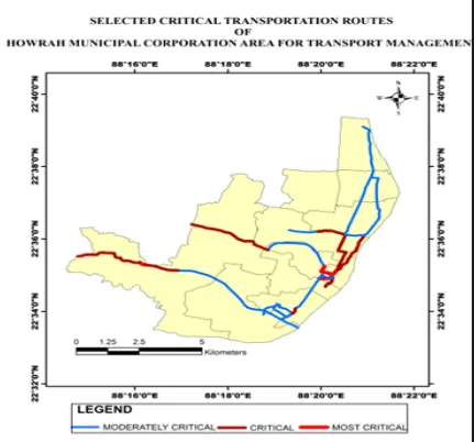
[image:6.595.307.548.262.559.2]On the basis of those six parameters, the integrated critical transport roads are identified by the Weightage Overlay Method. It distinctly shows that the roads near Howrah to Howrah Maidan, Sanpur more to Japanigate, Bakultala to Andul and Satragachi to Gorpha are in most critical condition. On the other hand, the roads connecting Bally to Salkia and Belur to Howrah are in Critical situation and roads near Nabanna, Belgachiya, and Ramrajatala are moderately critical among the whole Howrah Municipal Corporation Area.
[image:6.595.54.285.484.732.2]Smart Transportation Management Planning To Reduce Surface Vehicle Pressure for a Better Urban Design of Howrah Municipal Corporation Area
4948
Published By:
Blue Eyes Intelligence Engineering & Sciences Publication
[image:7.595.62.278.52.253.2]Retrieval Number: L35631081219/2019©BEIESP DOI: 10.35940/ijitee.L3563.1081219
Fig 14 Selected Critical Routes of HMC Area The East-West Metro Line of Kolkata has been initiated by the Government of India in 2009 as an ambitious but the total construction is not finished properly to start the metro service in an east-west zone right now. [11] [12]
IX. LAND USE & LAND COVER MAP OF HMC AREA
Here a map of Howrah Municipal Corporation area is prepared to show the recent land use and land cover of the HMC area (2019, April) with an overall accuracy of 96%.
he pressure of urbanization is undoubtedly high in this area where the amount of open space is rare. There are small water
bodies are found in mainly Bally area, Satragachi, near Gorpha and Borough 5 & 6. Vegetation cover is moderate to
less in the whole area but makeable in Borough 6 & 7.
Fig 15: Land Use & Land Cover Map of HMC Area We should keep in mind that the management plans should be sustainable and eco-friendly to nature. So we have to plan the supplementary transport system without harm the environment which will solve the transportation problem of Howrah Municipal Corporation Area.
X. PROBABLE METRO ROUTE IN HMC AREA
On the basis of our analysis, the most critical and critical zones of transportation of HMC area are severed by this transport management plan. In spite of being a moderately critical zone, only the Nabanna area is included in this management plan as it is the head administrative centre of the West Bengal Government and though it is less in residential population the rate of commuting is high in this area. This probable metro route can join with the east-west metro corridor project of the Kolkata Metro Service.
The first probable metro routes are started from Bally towards Howrah Maidan joining the stations of Bally Badamtala, Belurmath, Liluah, Satyabala, Salkia, Pilkhana, Howrah, and Howrah Maidan. This area is overpopulated, has several educational institutions, industrial area, recreations and most importantly a large number of people daily commute to Kolkata from this zone.
[image:7.595.313.542.323.567.2]Secondly, the route can continue its journey from Howrah Maidan to Gorpha by joining Fajir Bazar, Shibpur, Nabanna, Carry road, Baksara and Satragachi. This area is recognized as a service-oriented area. A large number of people came here daily for their job purposes and Nabanna is one of the significant nodal points.
Fig 16: Probable Metro Route of HMC Area
A tributary route can join Howrah Maidan to Japani Gate by joining Bellilius Park, Tikiapara, Dasnagar and Balitikuri. These areas are overpopulated and have low connectivity towards Kolkata.
The metro stations can be constructed in the proposed locations by using the open space near the metro line and very less amount of vegetation coverage area have to use to construct the stations.
From the ground survey, we came to know that 200 sq. meters is the minimum area to construct an exit point of the metro stations. In this respect, the open space which we identified from the land-use & land-cover map of the HMC area can be used to construct the metro stations.
The route should be undergrounded because there is not sufficient space to construct an
[image:7.595.52.287.442.716.2]International Journal of Innovative Technology and Exploring Engineering (IJITEE) ISSN: 2278-3075, Volume-8 Issue-12, October 2019
[image:8.595.53.286.86.331.2]As well as the advantage of the undergrounded route is that, the government has not to give permanent rehabilitation to the affected residents.
Fig 17: Probable Metro Route on Land Use & Land Cover Map of HMC Area
XI. CONCLUSION
From the above analysis of the transport networks, it is clearly seen that the connectivity of the HMC area is quite good in the north and eastern part (i.e. Borough number – 1, 2,3,4,5 Bally and Belur), but the connectivity in the interior parts is less towards Kolkata.
From the ground survey, we came to know that the delay in arrival of the local trains is a common issue of railway transportation in the middle section of the HMC area. Tikiapara Railway station, Padmapukur Railway Station can be sited as an example.
Basically, the HMC Area was an industrial region in the years of late 19th century, but the gradual change in job pattern from industrialization towards providing service is notable. Maximum servicemen of this area doing their job in various parts of Kolkata. The importance of the daily office joining time is more important to a serviceman than an industrial laborer who has his own small industrial business.
The problem of transportation, particularly in the HMC area is also a matter of thought to the West Bengal Government. Honorable chief minister Mrs. Mamata Banerjee inaugurates a plan of ring flyover to reduce the traffic congestion in the HMC area on January 27 in 2016 which will connect the Howrah station with the east-west bypass. This ring flyover will join Rishi Bamkim road, Kartik Chandra Dutta Road, Foreshore Raod, and Kona Expressway. Though the plan passed in 2016 but never achieved till now. Not only that, the main concern is, the Government do not proposed any plan for rehabilitation for the affected people. Even the local people are worried about the planning of construction and solving the congestion.
The transport system of Howrah is often chosen as a research topic for the analysis of transport conditions and to state the problems of it, but this paper will be the first to suggest any supporting transport system for the better urban structure. We analyse the critical transportation roads of HMC area by
applying Weightage Overlay Method, considering six important parameters like total number of existing buses, width of the major roads, surface vehicle pressure on office time in the study area, crowd ness of the roads, personal vehicle preferable route and commercial vehicle preferable route, to increase the connectivity and reduce the congestion towards north to south more than east to west of the area, which is never done before in any research work. The management of Toto and Auto service is already started in the HMC area to reduce unnecessary congestion at a local level but it is not applicable to solve the transport problem of the whole Howrah Municipal Corporation area permanently. Keeping these matters in mind as well as with the available open land in HMC area, the matter of sustainability, the land use - land cover map of Howrah Municipal Corporation Area and on the basis of people’s necessity, we tried best to plan the probable metro route in Howrah Municipal Corporation Area.
ACKNOWLEDGMENT
We are highly thankful to the authorities of Regional Transport Office Howrah, West Bengal Transport Corporation Limited, Howrah Municipal Corporation, Development and Planning Department of Howrah and all respondents for helping us.
REFERENCES
1. D. C. Handbook, “West Bengal,” 2011.
2. H. M. Corporation, “E-Newsletter HISTORY OF HOWRAH.” 3. T. Dey, “CHANGING PROFILE OF STATE TRANSPORT
UNDERTAKINGS IN MASS TRANSPORT SERVICES : A CASE OF KOLKATA CITY,” vol. 2, no. 2, pp. 45–56.
4. T. Das, S. Chakraborty, and K. Samanta, “Urban sprawl and urban growth detection analysis : A comparative study of Kolkata municipal corporation and Haora municipal corporation,” vol. 7, no. 1, pp. 82–92, 2016.
5. M. Thesis, “IMPACT OF METRO ON THE DEVELOPMENT.” 6. A. Chakraborty and R. Ray, “Howrah Bridge and Second Hooghly
Bridge: A Comprehensive Comparative Study,” vol. 4, no. 9, pp. 243–248, 2013.
7. T. Congestion, A. Emission, I. N. The, and O. F. Kolkata, “CHAPTER - IV TRAFFIC CONGESTION AND AUTOMOBILE EMISSION IN THE CITY.”
8. T. Dey, “A PROFILE OF ROAD TRANSPORT DEVELOPMENT IN HOWRAH DISTRICT , WEST BENGAL , INDIA,” vol. 3, no. July 2013, pp. 139–149.
9. G. E. Kofi, “Network based indicators for prioritising the location of a new urban transport connection : Case study Istanbul , Turkey Network based indicators for prioritising the location of a new urban transport connection : Case study Istanbul , Turkey,” 2010.
10. A. D. Nagne, A. D. Vibhute, B. W. Gawali, and S. C. Mehrotra, “Spatial Analysis of Transportation Network for Town Planning of Aurangabad City by using Geographic Information System,” vol. 4, no. 7, pp. 2588–2594, 2013.
11. I. R. Chowdhury, “Traffic Congestion and Environmental Quality : A Case Study of Kolkata City,” vol. 4, no. 7, pp. 20–28, 2015. 12. F. City, “The Journey of Metro Railway in this City East West Metro
Corridor Unique Features of this Project Progress Achieved So Far :,” pp. 4–7, 2018.
AUTHORSPROFILE
Smart Transportation Management Planning To Reduce Surface Vehicle Pressure for a Better Urban Design of Howrah Municipal Corporation Area
4950
Published By:
Blue Eyes Intelligence Engineering & Sciences Publication
Retrieval Number: L35631081219/2019©BEIESP DOI: 10.35940/ijitee.L3563.1081219
Joydip Datta, pursuing M. Tech in Geographic Information Systems from NIIT University. He completed his Masters in Geography from University of Delhi. His research focuses primarily on Human-Environment Relationships, Landuse and Landcover Change, Impact of Deforestation, Water Resource Management,Solving Urban Problems and Relevant Planning,Geo-Psephological Analysis.
Dr. Sayanti Poddar, Lecturer of Asutosh College, University of Calcutta. She completed her Ph.D. from University of Calcutta, Department of Geography. She usually teaches Philosophy of Geographical Thought, Statistical Analysis and Regional Planning of Geography.