~'
',,--,,'
"-'~'
.~
'
'
'
-
'-"'-.-.
'
-'.,
'
-Chapter1 -Introduction
CHAPTER 1: INTRODUCTION
1.1 Introduction
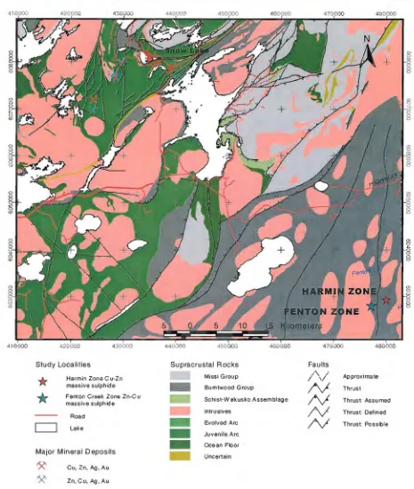
The Fenton Creek and Harmin zones are two polymetallic Zn-Cu/Cu-Zn massive sulphide deposits, which occur southeast of the Snow Lake volcanic hosted massive sulphide (VHMS) district, located in the province of Manitoba, Canada (Fig. 1.1). The two zones were discovered during the winter of 1998, following a multi-discipline exploration program of airborne (Spectrem)/ground geophysics and an extensive diamond drilling conducted by Hudson Bay Exploration And Development Company Limited (HBED) (Gilmore et aI., 1999). The two zones are multi-lensed bodies, considered to be hosted within metamorphosed volcanics and/or sediments, which are overlain by approximately 30 meters of Palaeozoic limestone and dolomite and 20 meters of muskeg. Diamond drilling of the two zones has defined a combined geologic resource of 5,296,805 Mt @ 4.67% Zn, 1.5% Cu, 21.95g/t Ag and 0.17 g/t Au (Gilmore et aI., 1999).
1.2 Location, Access and Physiography
The Fenton Creek zone is located 70 kilometres southeast of the townsite of Snow Lake, Manitoba and 25 kilometres east-southeast of Hargrave Lake at UTM coordinates 477170E, 6028080N (UTM Zone 14) (Fig. 1.2). The Harmin zone is located 3 kilometres east-southeast of Fenton Creek zone at UTM coordinates 479990E, 6029365N (UTM Zone 14).
Chapter1M Introduction
.~
94'
0':;:::>
Hudson 8
".
Churchill ~.",..
1000
102" 10,4"
104" 10,6'
:eo
~Flin~
2 •• Churchilllake
Reindeerlak-...lfCi'"
c::=J provincal Boundaries
/"V
Roads/ ' \ / Rivers
Ett',"<.1 Large Lakes
Lake Athabasca
1060
,
..
•
10e' 112' 60" 110"
,
..
*
SI.,dV LocationLocation Map Legend
Population Centres
G> CilV
o Township
g
'_.
'-~'
.~~
'- Figure 1.1 Location map of the Fenton and Harmin zones to major popuiation centres in Saskatchewan&Manitoba, Canada (created from data compiled by ESRI data and Maps August, 1999)
Physiography in the vicinity of the Fenton and Harmin regions consists of relatively flat low-lying areas of muskeg. The region is drained by the small east flowing Fenton and Husyk Creeks. Vegetation consists of spruce and pine trees, small shrubs, buck brush, grasses and mosses (Fig. 1.3). Summer temperatures average 20°C while winter temperatures often hover around -20 to -40°C. Wild life includes deer, black bears and numerous small fury creatures.
'
(
( ( I ( ( ( ((
(
(
( \~
@-8:
"
Q % ~ ,
-.~
8500000
Hard loose NIA NIA'
v
"-../
v
~;
~
"---,
'---\....:./
[image:4.594.108.548.58.342.2]Chapter1 - Introduction
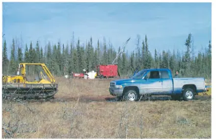
Figure 1.3 - Photograph showing typical topography and vegetation in the region of the Harmin and Fenton zones (Photo from HBED archive).
1.3 Exploration History
Regionally prospecting and mineral exploration within the Flin Flon and Snow Lake districts dates back to the beginning of the 20th century. The first discoveries made were
lode gold deposits near Snow Lake, however, polymetallic VHMS style mineralisation was not found until 1915 with the discovery of the Mandy Mine, which was later put into production in 1917 (Richardson and Ostry, 1987). The largest deposit to be found to date is the Flin Flon deposit conSisting of 62.92 million tonnes grading 2.2% Cu, 4.1 % Zn and 2.2g/t gold and was found in 1915, but was not put into production until 1930 due to metallurgical problems (Galley et al. , 1991).
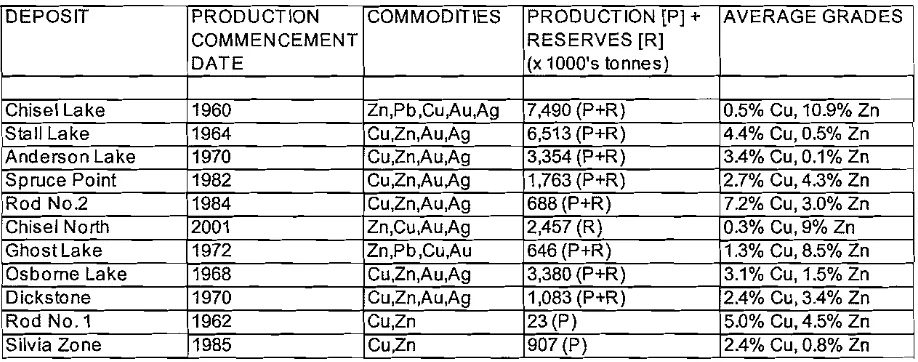
The first VHMS deposit to be found in the Snow Lake district was the Chisel Lake deposit in 1960 and consisted of 7.29 million tonnes grading 0.5% Cu and 10.9% Zn (Galley et aI., 1991). This discovery was followed by further finds from 1962-1985 including the Rod No.1, Stall Lake, Osborne Lake, Anderson Lake, Ghost Lake Cu-Zn-Au-Ag deposits (Galley et al., 1991 )(See Table 1.1 for complete details)
.~
'
-
'-.~.
'.~~
- '
[image:5.595.100.559.95.276.2]Chapter1 -Introduction
Table 1.1 - Historical tonnages, grades and production dates for VHMS deposits of the Snow Lake District (modified after Galley et. ai, 1991)
DEPOSIT PRODUCTION COMMODITIES PRODUCTION [P] + AVERAGE GRADES
COMMENCEMENT RESERVES [R]
DATE (x 1000's tonnes)
Chisel Lake 1960 Zn'pb,Cu,Au,Ag 7,490 (P+R) 0.5% Cu, 10.9% Zn
Slali Lake 1964 CU,Zn,Au,Ag 6,513 (P+R) 4.4% Cu, 0.5% Zn
Anderson Lake 1970 CU,Zn,Au,Ag 3,354 (P+R) 3.4% Cu, 0.1% Zn
Spruce Point 1982 CU,Zn,Au,Ag 1,763 (P+R) 2.7% Cu,4.3% Zn
Rod No.2 1984 CU,Zn,Au,A9 688 (P+R) 7.2% Cu, 3.0% Zn
Chisei North 2001 Zn,Cu,Au,Ag 2,457 (R) 0.3% Cu, 9% Zn
GhostLake 1972 Zn'pb,Cu,Au 646 (P+R) 1.3% Cu, 8.5% Zn
Osborne Lake 1968 CU,Zn,Au,Ag 3,380 (P+R) 3.1% Cu, 1.5% Zn
Dickstone 1970 CU,Zn,Au,Ag 1,083 (P+R) 2.4% Cu, 3.4% Zn
Rod NO.1 1962 CU,Zn 23(P) 5.0% Cu, 4.5% Zn
Silvia Zone 1985 CU,Zn 907(P) 2.4% Cu, 0.8% Zn
In 1996 Hudson Bay Exploration and Development Company Limited (HBED) targeted the Hargrave Lake region as having potentially favourable metavolcanic and metasedimentary rocks under the Palaeozoic sedimentary cover rocks, which are known to host VHMS style Cu/Zn mineralisation in areas to the north. A 2500 square kilometre SPECTREM EM/MAG airborne geophysical survey was flown over the area, which located numerous EM conductors and magnetic anomalies (Gilmore et aI., 1999). In 1997 exploration Permit #155 was acquired by HBED to cover anomalies located with the geophysical survey. Following the acquisition of the exploration permit, ground EM and magnetic geophysical surveys were conducted to refine airborne anomalies and initial diamond drilling was completed on some grids (Gilmore et aI., 1999).
In 1998 helicopter drilling on one of the EM targets discovered the Fenton Creek zone. Further helicopter supported drilling was completed in September and October of that year prior to the reduction of Permit #155 and the subsequent staking of the first claims over the Fenton Creek zone (Gilmore et aI., 1999).
In 1999 winter road access and drilling located the Harmin zone 3 km to the northwest of the Fenton Creek zone. Continued effort in this area also discovered two other unnamed zones of mineralisation, located 1.4km east-southeast of the Harmin zone and 1 kilometre south along strike of the Harmin zone (Gilmore et aI., 1999)
~'
"_.-~
'-..,,--"
.',---Chapter1 -Introduction
1.4 Previous and Current Work
Previous work completed on the Fenton Creek zones include airborne, ground and borehole geophysics, diamond hole drilling and interpretation, geochemical assaying, wholerock geochemical analysis (Gilmore et aI., 1999). The type and amount of work type has been tabulated and is shown in Table 1.2.
In addition to the physical work one in house report compiled by Gilmore (1999) covers the geology, geophysics and geochemistry of the Fenton and Harmin zones. InOctober of 1998 Dr. J.F. Harris of Vancouver Petrographics Ltd. completed a petrographical report on 5 samples taken from the Fenton zone. In May of 2000 Mr. R.C Wells a (P.Geo, FGAC, Consulting Geologist) for Kamloops Geological Services completed a petrographic, lithogeochemical, and interpretive report using 31 polished thin sections, geological logs and geochemical analyses.
Table 1.2 - Summary of work completed on the Fenton Creek zones (Gilmore et al. 1999)
WORK HISTORY
FENTON CREEK ZONE
WORK TYPE DATE #OF HOLES/ METERAGE/
GRIDS NO. SAMPLES
Ground EM/MAG Survey 1997/98 Grid Har30 24,499m
Diamond Drilling 1998/99/00 17 5,904.5m
Borehole Pulse Surveyil1Q 1998/99/00 17 5,904.5m
Wholerock Geochemical Samples 1998/99/00 17 313
Assav Samples 1998/99/00 17 716
1.5 Geological Resource
Drilling of the Fenton Creek and Harmin zones has defined an estimated geological resource as seen in the Table 1.3. The resource listed was calculated using the polygonal method, measured specific gravity for each intersection and did not include the effects of dilution or recovery analysis (Gilmore et a\., 1999).
" ' _ i
-'
'_.
.~
'~.
'
-
'-
'
-
'-0 - .
Chapter1 -Introduction
Table 1.3 - Preliminary ore resource estimates for the Fenton and Harmin Creek zones (from internal company report Gilmore K.H. et al. 1999)
ORE RESOURCE ESTlMA.lES
Zone Name tonnes
Au
(glt)
Ag(glt)
Cu (o/~zn
(o/~Fenton Creek Zone
2,329,889
0.09
20.42
0.56
7.44HanninZone
2,966,916
0.23
23.16
2.23
2.49
Total
5,296,805
0.17
21.95
1.5
4.67
1.6Aim and Scope ofthis Study
The Fenton Creek and Harmin zones represent two new VHMS discoveries located south of the Snow Lake VHMS districts below substantial thicknesses of Palaeozoic cover rocks. The discovery of these zones may indicate a new mineral district or the southerly extension of the existing Snow Lake belt. Do to a lack of appropriate representative samples in the Harmin zone; this study will focus exclusively on the data and samples collected from the Zn-rich Fenton Creek zone.
The aim of this study is to use existing data which includes drill logs, geophysical surveys, contractors reports, assay and wholerock analyses, in conjunction with samples collected by the author, in order to:
1) Describe and characterize lithologies of footwall and hanging wall host rocks of the Fenton Creek zone.
2) Describe alteration mineralogy, distribution and lithogeochemistry of the Fenton Creek deposit.
3) Describe the ore petrography and metal zonation from the Fenton Creek zone. 4) Generate geological model for the region that may help relate these new zones
two existing deposits in the area.
To satisfy these aims the author has completed the following:
1) Collected 106 representative samples from diamond drillholes Har01 0, Har018, Har021, Har043 and Har044.
2) Created an access database containing the samples used in this study.
3) Described and interpreted 45 polished thin sections some of which were used to characterise the geology of the sampled drillholes.
4) Reinterpreted existing geologic logs and sections using lithogeochemical results.
'-
"-~
'~-~~'
' - '
,--",'
Chapter1 -Introduction
5) Compiled all available wholerock, and ICP-MS data for the Fenton Creek drillholes, generated various geochemical discrimination plots and created geologicall geochemical downhole plot for ddh Har043.
6) Compiled HBED assay data for Fenton Creek and generated various gridedl contour maps for Cu, Zn, Pb, Au, Ag & As.
7) Sampled, prepared and interpreted the results of carbon isotope analyses for 3 samples from the graphitic rocks collected along section 400N.
,~
.~
'--~.
-
'-.-.~
Chapter2-Regional Geology
CHAPTER: 2 REGIONAL GEOLOGY
2.1 Introduction
The Flin Flon Belt is a 380km long east-west trending package of Paleoproterozoic volcanic arc rocks hosted within the 500km wide northeast-southwest trending Trans Hudson Orogen. Since the first discovery of copper and zinc in the region, the Flin Flon Belt has been the topic of much study. Recently there has been renewed interest in the region following the public release of the NATMAP Shield Margin Project GSC Open File 03884 and accompanying memoirs/reports. This multi-disciplined project has compiled, and where necessary re-interpreted, much of the geology of the Flin Flon and Snow Lake region. As a result of this study the Flin Flon Belt has be divided into the three following assemblages (1.) Glennie Complex (2.) Flin Flon Assemblage (3.) Snow Lake Assemblage, the latter being of most significance to this study. This chapter reviews the general tectonic setting, regional geology, alteration, metamorphism and metallogeny of the Snow Lake Assemblage located at the eastern end of the greater Flin Flon Belt with the aim of providing a regional framework into which the newly discovered Fenton Creek zones might fit.
2.2 Tectonic Setting
The Snow Lake area is located at the eastern end of the Flin Flon Belt, a 380km long east-west trending package of arc volcanics located in the juvenile Internal Reindeer Zone of the Trans Hudson Orogen (THO) (Hoffman, 1988). The THO is a 500km wide northeast-southwest trending zone of collision between the Superior and Slave cratons of central Canada (Fig. 2.1). The Orogen is comprised of four major lithotectonic zones (Hoffman, 1988; Galley et aI., 1991; Lucas et aI., 1999):(1) The Superior Boundary zone is a package of Proterozoic clastic-carbonate shelf
sequences overlying the edge of an older Archaean craton of the Superior Province and intruded by mafic-ultra mafic intrusions thought to be related to the nickel deposits of the Thompson nickel Belt. (2) TheInternal Zone (otherwise known as the 'Reindeer
Chap~r2-Reg0naIGeo0gy
'"
~
'"
.~
'" 10.0'
10,')0
104' 106'
MESOZOIC
10.8'
100 0
'> ·1:'t:'NI:1~I:1I.li \ !
f
-
i c·> T-i i i I
108' 106' 104' 102' 100' 98' 96' 94° 92'
Tecton ic 0 om ains
~ CenozOICCarbonates c.::J Remoblh2eo Archean BaSin liiJi'~1 Arc Votcanlcs
CJ
MeSOZOIcCafbonates c.::J Arc Gran i(01(j5II1II
Irllerarc turbt(Jiles&continental molassePaleOZOICCarbonates c.::J Shell·fore deap prisms II!I!!II Shell·lore deep prisms
c.::J ContInental SedIments
CJ
10 Ierarc lu rbidites&conIIne ntal molassec:::=J
Arch ean base men l &,'"
&,
'"
b '" N '" ,--:'
~
v
\-.-
l-
'-
"---\.-.- Figure 2.1 Tectonic Domains
The Trans-Hudson Orogen is a 500km wide Northeast-Southwest trending zone of collision between the Superior and Slave cratons of Central Canada.
'---..--'
Cu-Zn volcanic hosted massive sulphide (VHMS) deposits of the Flin Flon and Snow Lake assemblages. (3) An Andean-type Magamatic Arc known as the Wathaman-Chipewyan Batholith which is the result of northwest directed subduction of the Reindeer Zone. (4)Hinterland Zone, a package of Proterozoic clastic-carbonate shelf sequences referred to as the Wollaston and Hearne/Rae Province.
The earliest event recording the evolution of the THO is thought to be the deposition of clastic-carbonate shelf sequences along the boundaries of the Archean Superior and Hearne cratons pre-1.9 Ga. (Lewry and Sibbald, 1980; Bleeker and Macek, 1988a). This event was closely followed by deposition of clastic sedimentary sequences and
\ - - -'
'
-~
~.
'
-,
,
Chapter2-Regional Geology;
igneous intrusions, including the mafic-ultramafic intrusion related to the Thompson
l
nickel deposits along the margin of the Superior Province and the formation of a foredeepl (Hoffman, 1988).The formation of the Internal juvenile Proterozoic crust (Reindeer Zone) followed the sedimentation along the cratonic boundaries, commencing approximately 1.9 Ga (Hoffrnan, 1988). During this event island-arc volcanism dominated, with the formation of the Lyn Lake Belt at 1.91 Ga (Baldwin et aI., 1987), followed by the Flin Flon and La Ronge belts at 1.89 Ga (Van et aI., 1987; Gordon et aI., 1990) and concluding sometime between 1.88-1.77Ga with the formation of the Rusty Lake Belt and subsequent deposition of volcaniclastic sediments within interarc basins (Galley et aI., 1991). During the next stage of development in the THO, the same subduction related to the formation of the juvenile volcanism continued northwest which resulted in the emplacement of Andean-type calc-alkaline granodiorite-granite intrusions of the Wathaman-Chipewyan batholith (Hoffman, 1988). During and following this intrusion phase the island arc assemblages were uplifted and deformed by isoclinal folds (F1) followed shortly after by erosion and continental molasses sedimentation infilling the inter-arc Kisseynew basin (Hoffman, 1988).
Following ernplacement of the Wathaman-Chipewyan batholith the juvenile accreted terranes recorded south verging thrust-nappe deformation (F2), while the region then underwent a metamorphic event in which the P-T condition reached 750°C at 5.5Kbars within the Kisseynew Belt (Gordon et aI., 1987). The finals stages of development of the THO saw peak metamorphic conditions recorded at 1815Ma coincident with the formation of trending doubly plunging folds (F3). This event was followed by formation of NE-trending ductile fault systems and late brittle-ductile deformation along pre-existing fault zones post 1.77Ga (Galley et aI., 1991). The Proterozoic tectonic events (Table 2.1) within the Trans Hudson Orogen have been well summarized by Galley (1991).
2.3 Geologic Setting of the Snow Lake Arc Assemblage
Historically the Flin Flon Belt has been divided into two stratigraphic groups, namely the Amisk Group that consist of arc volcanics and the Missi Group that consist of continental
sedimentary rocks (Bruce, 1915; Harrison, 1951). Recent reinterpretation and new work by researchers completing the EXTECH I and NATMAP Shield Margin programs have redefined much ofthe understanding of the Flin Flon Belt. Based on geological, temporal
( ( ( ( I ( ( ( ~ N Table 2.1 -Early Proterozoic tectonic events within the Trans-Hudson Orogen (modified after Galley et aI., 1991)
Time
Intervall
HINTERLAND
ANDEAN
MAGMATIC
ARC
INTERNAL
ZONE
FORELAND
I
'HEARNE PROVINCE' 'WA THAMAN·CHIPEWA YN 'REINDEER ZONE' CHURCHILL·SUPERIOR BATHOLITH' BOUNDARY ZONE Shelf sedimentation along margin of Shelf sedimentation along margin of craton craton: Foredeep sedimentation and volcanism emplacement of Ni~rich intrusions Pre 1.9Ga 1.9 to 1.88Ga F1: Nappe formation Island arc and oceanic rift Thickenjn~ and stabilization of cratonic volcanism and associated margin. In rusion of Molson dyke swarm sedimentation result in island arc and related Fox River Sill. and interarc basins formation NWRverging napBes infold Intrusion of early kinematic tonaliteI
supracrustals wi h underlying Archean and granodiorite. Volcanism in 1.88 to 1.77 Ga basement Rusly Lake bell Intrusion of the Wathaman-Chipewyn batholith F1 :lsoclinal fOldin~ and uplift of --island arc assemo ~es with intrusion of interme late batholiths 1.86 to 1.84 Ga Continued uplift and subsequent erosion and continental molasse sedimentation infilling interarc Kisseynew basin. Syn kinematic plutonism and continental volcanism 1.84 to 1.83 Ga Rafting of the Peter Lake exotic F2: South ver~ing thrust-nappe F2: Southeast verging thrusts emplace terrane onto the Hearne margin. deformation 0 juvenile accreted Kisseynew ~neisses over the Metamorphism of shelMoredeep terranes: Regional metamorphic Thompson ickel Belt Wollaston Group event centered on the Kisseynew bell 1.83 to 1.77 Ga F3: Peak metam0Tchism at 1.815 F3: Formation of NE-trending, doublyM Ga along with the ormation of NE-plunging folds. trending, doubly-plunging folds. Formation of myolite zone between Formation of NE-trending, ductile Formation of large scale, dipMSlig fault Hearne Province and the Watha man-fault systems zones parallel to NE·trending F folds Chlpewayn batholith. Post 1.77 Ga Late brittle·ductile movement along Late brittleMductile deformation Late brittle-ductile deformation along pre-domain boundaries along preMexisting fault zones existeing fault zonesChapter2-Regional Geology
~
/
and structural differences the volcanic arcs of the Flin Flon Belt can be divided into the three following assemblages, the Glennie Complex located east of town of Flin Flon, the Flin Flon Assemblage centred around Flin Flon and the Snow Lake Assemblage near the town of Snow Lake (Fig. 2.2). Due to the limited scope of this study, the geology of the Glennie Complex and the FIJn Flon Assemblages will not be covered in any amount of detail. For information regarding these assemblages the author recommends (Bailes and Galley, 1999) who give good interpretations and detailed descriptions of the rock units in these assemblages .
106'
.~
99'
A
100'
100' 101'
10F
-~
FENTON/HARMINZO"We---",I'
INTERIOR PLATFORM
102' 103'
103' 50
104' o
105' 50
ATHABASCA BASIN
:lI-I MESGZOIC COVER
.../
v
v
~;'
G
~
"---'
TectoniC Domains
*
StUdy Locationc=:>
CENOZOIC'*
c:::;;> MESOZOIC. / VHMS Districts
c::Y
PALEOZOIC Flin Flon Beltc=>
ATHABASCA BASIN Arc Volcanicsc=:>
RAE/HEARN PROVINCEc=>
CHIPEWYANc=:>
WOLLASTON FOLD BELTC:>
SOUTHERN INDIAN GNEISSARC INTRUSIVES & SEDIMENT KISSEYNEW GNEISS BELT _ _ THOMPSON NtCKEL BELT
c=:::>
SUPERIOR PROVINCEFigure 2,2 Tectonic domains of the Trans-Hudson Orogen including the location of the Fenton/Harmin zones in relation to the Flin Flon and Snow Lake VHMS districts of the FUn Flon Belt (modified after Galley et. ai, 1991)
D
Synvolcanic tonalite '""""-' SUlphidic layerD
Felsic breccia ~'--
Copper dominant depositD
Rhyolite ~ Zinc dominant depositD
Dacite0
Mafic volcaniclastics•
Fe-basalt-
Porphyritic basalt• Aphyric basaltt
~
I
~
'-.-/
' " - , , ,
\..../
"--..r
'--/
,--.
",--.
'
-Chapter2-Regional Geology
The geology of the Snow Lake region is dominated by the Snow Lake Assemblage (formerly defined as the Amisk Group), subordinate amounts of Missi Group and Palaeozoic Internal Platform carbonates.
2.3.1 Snow Lake Assemblage
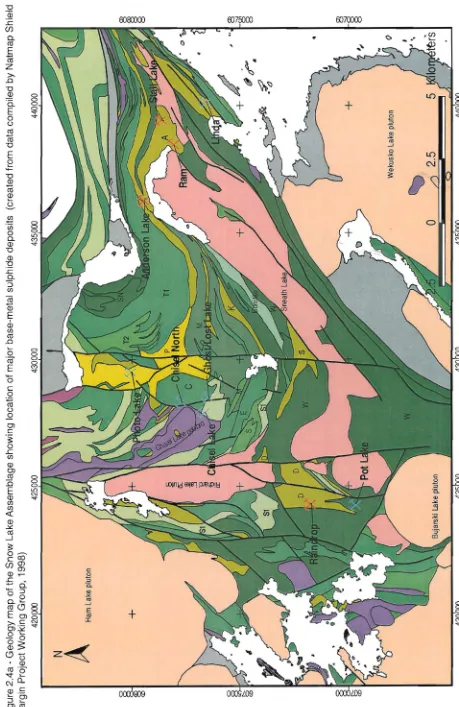
The Snow Lake Assemblage is a 20km wide, 6km thick, fault bounded, northeast dipping allocthonous volcanic arc that is host to numerous Cu-Zn and Zn-Cu VHMS deposits. Recently the Snow Lake Assemblage as defined by Bailes and Galley (1999), consists of 3 geochemically, and morphologically distinct groups: primitive arc, mature arc and arc rift rock sequences. It is believed that these groups represent progressive stages in arc development from primitive, to mature to incipient rifting (Fig. 2.3, 2.4a and 2.4b).
Mature Arc Deposits
C Chisel Zn-Cu
GH Ghost Lake Zn-Cu
LO Lost Zn-Cu
PH Photo Cu-Zn-Au
Primative Arc Deposits
A Anderson Cu-Zn
J Joannie Cu-Zn
LD Linda Zn-Cu
P Pot Zn-Cu
R Raindrop Cu-Zn
RD Rod Cu-Zn
RM Ram Cu-Zn
S Stall Cu-Zn
Figure 2,3 - Schematic startigraphic section showing the setting of the major base-metal rich sulphide deposits of the Snow Lake assemblage (modified after Bailes, 1999)
c-"
~
(
\~
(
(
(
(.
\.
(
c
(
(
(
(
c.
~
¥
... f\)~
~ G)!
8 § 8
I
I
".I
8 ~ 8
+
2.5
Wekus
ko
Lake
pluton
o
435"000
+
Ham
Lake
pluton
N
A
Figure
2.4a
-Geology
map
of
the
Snow
Lake
Assemblage
showing
location
of
major
base-metal
sUlphide
deposits
(created
from
data
compiled
by
Natmap
Shield
Margin
Project
Working
Group,
1998)
420000
425000
430000
435000
440000
I
!
I
!
!
1
__
".55
(Sib
is
j
UX
[image:15.841.92.551.71.778.2]Chapter2-Regional Geology
LEGEND
IVajor Mineral Deposits SnowLake Asserrtllage
Faults
Intrusive Rocks Mssi Group Burntwood Group
Felsic vdcaric rocks L - LCMer nine felsic S - 9roud Lake feisic b'eocia
Fhldfte
A -I'nderscn
G - Gh::>Sl!Phcto D-Daly S- Sneath
K-I<onzie
C- Clisel
A:r,\cahoose dacfte
Porphrymic basalt Sn - SOOI Lal<e
T -Threeh:Juse
Ebritite
Aphyric~saIt
W - WeldlLake
SN - SroN Lake
/omp'libdite
M9fiCvolcaniclastic Th - Threel100se
C- Clisel
Sn - SOOI Lal<e
Ivb"re Lal<e Fe-basalt
CJ
D
CJ
o
o
Gfe}Wacke, mudstcne, siltstone P - PariSian formalicn
"X:'
Zn,cu,I>Q.Au'X'
OJ, ln,/!g,Auo
o
Ssndstone. siltstone, mLdstone and derived gneisso
<?abbro. diOrfte, diataseo
Fasic Plutcnso
Stnvdcanic tonaliteJ
~
~
~.
[image:16.594.147.545.59.371.2]-"'
Figure 2.4b - Legend for geology map of Snow Lake Assemblage (created from data compiled by Natmap Shield Margin Project Working Group, 1998)
Primative Arc
"-The primitive arc group is the lowest in the section and is characterised by a thick sequence (> 3km) of pillowed aphyric to sparsely porphyritic basalt, basaltic andesite, andesite flows (Welch Lake basalt) and an associated unnamed high Ca-bonite (Galley et aI., 1991). Within these basalts are a series of aphyric to sparsely quartz phyric rhyolitic domes (Daly Lake, Sneath Lake, Konzie and Anderson Lake rhyolite), which are closely associated with the polymetallic massive sulphide deposits (Galley et aI., 1991). The entire sequence is then intruded the Sneath Lake syn-volcanic tonalite intrusion. To date a total of 8 significant Cu-Zn and Zn-Cu deposits have been identified within the primitive arc group.
~ Mature Arc
'
-L:
~.
The mature arc group is characterised by a 2-3km thick variable suite of volcanic rocks (Galley et aI., 1991; Bailes and Galley, 1999). The lowest portion of the group consists of thick-bedded felsic breccias (Stroud Lake felsic breccia 1892 +/- 3Ma (David et aI., 1996). This is followed by sub-aqueously deposited felsic and heterolithic mafic breccia (Snell Lake and Edwards Lake). Overlying these units are mafic to felsic volcanic flows
\',--",
\"~j
-'-..
- "
"-~'.
Chapter2-Regional Geology
(Moore Fe-basalts & Powderhouse dacites). On top of the Powderhouse dacite and forming the Chisel basin are the Photo, Ghost and Chisel rhyolitic domes that are also the footwall to the Chisel, Lost and Ghost Zn-Cu and the Photo Lake Cu-Zn VHMS deposits. The hanging wall to these deposits is comprised of mafic tuff, lapilli tuff, tuff breccia and related porphyritic basalt flows (Chisel basin mafic tuff & Threehouse basalt). Forming the upper most sequence to the mature arc group are the Threehouse mafic volcaniclastics and unnamed felsic breccia. To date a total of 4 significant Cu-Zn and Zn-Cu deposits have been identified within the mature arc group.
Arc Rift
The Arc rift group consists of a <1 km thickness of aphyric basalts of the Snow Creek formation. This formation is truncated by the Snow Lake fault, which is then overlain by the File Lake formation a volcaniclastic metagreywacke and mudstone turbidite unit that has been interpreted by Bailes (1980) to be part of a submarine dispersal system from eroded felsic volcanic detritus from the Flin Flon Belt volcanoes.
Intrusive Complexes
Two main subvolcanic intrusive complexes have been identified in the Snow Lake Assemblage (Figs. 2.3 & 2.4a). The Sneath Lake tonalite consists of a semi-conformable, broadly folded body, 1.5 km wide and over 14km long (Galley et aI., 1991). U/Pb zircon dating indicates that the Sneath Lake intrusion is 1886 +17/-9 Ma (David et aI., 1996), and is interpreted to be the associated heat source responsible for the formation of the massive sulphide deposits in the primitive arc setting (Walford and Franklin, 1982; Bailes, 1986).
The Richard Lake tonalite is a smaller intrusive complex measuring 1.7km x 7.3km and has been recorded cross cutting 3km of mature arc stratigraphy including a series of hydrothermal alteration zones (Galley et al., 1991). U/Pb zircon dating indicates that the Richard Lake intrusion is 1889 +8/-6 Ma (David et aI., 1996), indicating that it is a synvolcanic intrusion, however, it's relationship to the massive sulphide deposits in the mature arc setting is unclear.
2.3.2 Missi Group
The Missi Group is a sequence of metamorphosed lithic arenites, (Froese and Moore, 1980) conglomerates, cross-bedded fluviatile sandstones and minor volcanic rocks.
, , - - /
"--~ .
~
Chapter2-Regional Geology
Missi volcanic rocks are not present near Snow Lake but form a substantial part of the Missi Group east ofWekusko Lake (Galley, 1991 #91]. Gordon (1990) estimates the U-Pb zircon age to be 1832 +/-2 Ma, which is approximately 60Ma younger than the volcanics ofthe Snow Lake Assemblage (Galley et aI., 1991).
2.3.3 Palaeozoic Interior Platform
The rocks ofthe Interior Platform consist of a package of carbonates including limestone and dolomite that cover only the southern portions of the Flin Flon Belt including the Missi group and the Snow Lake Assemblage. The unit varies in thickness and outcrop from a couple of metres to >300m from north to south and is a significant barrier to exploration of the volcanic arc sequences of the Flin Flon belt.
2.4 Structure and Metamorphism
The Snow Lake Assemblage is characterised by fold-thrust style tectonics, which is thought to have occurred from 1.84 - 1.81Ga (Connors, 1996; Kraus and Williams, 1999). To date four folding events have been recognized, over no less than 3 successive deformation periods spanning 30Ma (Kraus and Williams, 1999).
The foiding events, based on kinematic indicators include: F1 and F2events - isoclinal folds and low-angle shear zones, F3 - NNE trending open to tight folds (eg. Threehouse synform) andF4-local west-northwest and east-southeast trending folds. These events have been summarized in Table 2.2.
Metamorphism within the Snow Lake Assemblage was first characterised by Froese and Gasparrini (1975), who divided Snow Lake region into four metamorphic zones based of metamorphic reactions in pelitic rocks: chlorite-biotite, chlorite-biotite-staurolite, biotite-staurolite-sillimanite and biotite-sillimanite-almandine. In general terms the metamorphic grade varies from lower greenschist facies in the south to upper (almandine) amphibolite grades in the north (Galley et aI., 1991).
( ( ( ( ( ~ (!) Table 2.2 -Summary of the tectono-metamorphic history of the Snow Lake Allochton (modified after Kraus and Williams, 1999) Deformation Structures Magmatic Events Metamorphism Age (Ga) Tectonic setting Arc volcanism; synvolcanic i~~ Synvolcanic fluid alteratio 1.892 -1.886 Subduction of intrusions (Sneath Lake Archean crust tonalite, Herbert Lake and
••
I<::NO'~" 1'''kA ..i0..
1.860 -1.840 Sedimentation of 01 & 02 Burntwood and Missi Groups Mafic dykes and sills Isoclinal folds and low-angle Calc-alkaline granitoid suite; '.IJWI,pro grade metamorphism: 1.840 -1.830 Overthrusting of shear zones; 81 parallel to Missi volcanic suite ~w Chlorite grade, T <400·C, Kisseynew Domain F1 primary layering P=4kbars over Snow LakeI~l
Allocation during N-S D3 convergence; crustal fmi' thickening: 12-15 km ~f\' Isoclinal curvilinear folds; regiona--~~
Thermal peak in staurolite 1.820 -1.810 Continued N-S F2 S2; low-angle shear zones and zone and lower, T<580·C, convergence; minor reactivation of F1 shear zones I@f, P=4-6kbars crustal thickening NNE-trending open to tight folds ~!l Cooling in staurolite zone; 1.810 -1.805 E-W shortening;W-II
F3 (Threehouse synform); thermal peak in sillimanite directed D4 crenulations of S2I~rl
zone and higher: T=600-underthrusting of 800·C, P=5-6 kbar Superior plate Local WNW-ESE trending folds; Pegmatites in siliceous zones [\ 1.800 -1.765 Renewed N-S kink bandsI
convergence; D5 F4 exhumation during (. orogen-parallel mOVAments Brittle featu resfii!
Blocking temperatures of 1.765-1.745 Ongoing exhumation " hornblende and biotite reached hi,
"_.-"-.
-,-'
,~
"--'/
Chapter2~RegjonalGeology
Thermal peak metamorphism in sillimanite zone and higher is thought to have occurred during the third fold phase and reached temperatures between 600-800°C and pressures between 5-6kbars (Kraus and Williams, 1999). For a summary see Table 2.2. As a result of the metamorphism and deformation in the Snow Lake Assemblage primary features, such as bedding, pillows, amygdales, etc., mayor may not be recognizable (Galley et aI., 1991). Furthermore, original textures in sulphide ores and hydrothermal alteration zones have for the most part been destroyed and/or replaced by coarser grained textures (Galley et aI., 1991).
2.5 Alteration
Three different styles of alteration have been recognized in the Snow LakeAssemblage: (1.) Discordant (2.) Semi-conformable (3.) Intrusive related alteration. The discordant, semi-conformable and intrusive related alteration styles are thought to be a result of hydrothermal alteration related to volcanism and synvolcanic two-phase tonalite intrusions, which occurred during the formation of the volcanic arc sequences 1892-1896Ma (Galley et aI., 1991; Galley and Franklin, 1991; Galley, 1993; Kraus and Williams, 1999)
2.5.1 Discordant Alteration
The discordant alteration occurs as small discrete "pipe-like" zones immediately below VHMS deposits which mayor may not join up with semi-conformable alteration as reported by the following investigators: Chisel Lake Zn-Cu deposit (Galley and Bailes, 1989; Bailes and Galley, 1989), the Anderson Lake Cu-Zn deposit (Walford and Franklin, 1982: Trembath, 1986), the Stall Cu-Zn deposit (Studer, 1922), the Rod Cu-Zn deposit (Coats et aI., 1970) and the Linda Cu-Zn deposit (Zales, 1989). The alteration in these pipe-like zones is characterised by chloritized cores and sericitized peripheries, but also includes Fe-Mg metasomatism silicification/albitization, and minor epidotization and pyritization (Galley et aI., 1991).
2.5.2 Semi-conformable Alteration
.~
'"-,,
-"
'~
'
-Chapter2-Regional Geology
amphibole replacement (Galley and Bailes, 1993). A third poorly understood type of local semi-conformable amphibole +/- sulphide alteration has been observed within immediate hangingwall to some ofthe VHMS deposits (Bailes and Galley, 1991). Another observation made regarding the semi-conformable alteration is that it appears to be restricted to individual formations and does not significantly effect overlying and underlying formations suggesting that hydrothermal fluid flow was conformable (Galley et aI., 1991).
2.5.3 Intrusive Related Alteration
The alteration in the subvolcanic intrusions consists of zones of disseminated chalcopyrite-pyrrhotite; fracture controlled epidote-quartz-hematite, chlorite-biotite-magnetite and chlorite-aluminosilicate alteration. This style of alteration has been noted by Walford and Franklin (1982) and Bailes and Galley (1991) within the Sneath Lake Pluton as close as 200 m from the Anderson, Stall and Rod deposits.
2.6 Metallogeny
The Flin Flon belt is host to numerous VHMS deposits (Table 2.3). In total, the Flin Flon belt contains approximately 118.7 Mt of polymetallic base metal sulphide ore in 25 past and producing mines (Syme et aI., 1999). The Snow Lake Assemblage located at the eastern end of the Flin Flon belt contains 7 past and producing mines totalling 20.6Mt of
polymetallic base metal sulphide ore (Syme et aI., 1999). In the Snow Lake Assemblage polymetallic Zn-Cu base metal deposits have been observed at two stratigraphic levels Primitive Arc and Mature Are, suggesting more than one mineralising event (Galley, 1999) (Fig. 2.3). This observation is supported by lead isotope research by Walford and Franklin (1982) on the Anderson-Stall-Rod Cu-Zn and Chisel-Ghost-Lost-North Chisel Zn-Cu deposits that indicate separate metal sources. In the Primitive Arc sequence the Anderson, Joannie, Linda, Pot, Stall, Rod, Raindrop deposits are associated with the Daly Lake and Anderson Lake rhyolite flows within the Welch Lake subaqueous aphyric basalts (Galley et aI., 1991). In the Mature arc setting the Chisel, Ghost, Lost and Photos Lake deposits associated with the Chisel basin/Threehouse mafic tuff-Iapilli tuff unit and associated Chisel and Ghost Lake rhyolite flows (Galley et aI., 1991).
2.7Summary
The Flin Flon belt is a 380km long east-west trending package of arc volcanics and related sediments located in the juvenile Internal Reindeer Zone of the Trans Hudson
~ I ( ( (
'"
Table 2.3 -Grades, tonnages and characteristics of selected polymetallic VHMS deposits of the Flin Flon belt (modified after Galley et aI., 1991)""-VHMS
Deposits
of
the
Flin
Flon
Belt
FUN
FLON
ASSEMBLAGE
Deposit Name Host Rock Mineralisation stvle Commoditv Tonaae/Grade Flin Flon Rhyolite flow/breccia massive/disseminated sulphides Zn,Cu,Ag,Au 63 Mt @ 2.2% Cu, 4.1% Zn Triple 7 (Under Development) Rhyolite flow/breccia massive/disseminated sulphides Zn,Cu,Ag,Au 14.5 Mt @ 2.5% Cu, 4.6% Zn Trout Lake sericitized quartz-phyric massive/stringer sulphides CU,Zn,Au,Ag 6.2 Mt @ 2.0% Cu, 5.4% Zn rhyolite --Callinan sericitized quartz-phyric Zn,Cu,Ag,Au 2.6 Mt@ 1.5% Cu, 4.1% Zn rhyolite sericite-carbonate schist ]zn,CU,A9,AU Schist frete(olithic felsic volcanic massive/stringer sulphides 1.8 Mt @ 4.3% Cu, 7.3% Zn reCCla)SNOW
LAKE
ASSEMBLAGE
Deposit Name Host Rock DeDosition stvle ditv /Grade C T Chisel Lake Rhyolite/Mafic volcaniclastic massive/stringer sulphides Zn,Cu,Pb 7.5 Mt @ 0.5% Cu, 10.9% Zn Chisel Lake (North) Rhyolite/Mafic volcaniclastic massive/stringer sUlphides Zn,Cu,Pb 2.4 Mt @ 0.3% Cu, 9% Zn Stall Lake Rhyolite massive/stringer sUlphides CU,Zn 6.5 Mt @ 4.4% Cu, 9% Zn Anderson Lake Rhyolite massive/stringer sulphides CU,Zn 3.3 Mt @ 3.4% Cu, 0.1 % Zn Osborne Lake Rhyolite massive/stringer sulphides CU,Zn,Au,Ag 3.3 Mt@3.1%Cu, 1.5% Zn"'.-"
~o
.~.
'.-'-..,/
.~
Chapter2-Regional Geology
Orogen, a 500km wide Northeast-Southwest trending zone of collision between the Superior and Slave cratons of Central Canada (Hoffman, 1988). The Flin Flon belt has been divided into the following domains/assemblages: (1.) Glennie Complex (2.) Flin Flon Assemblage (3.) Snow Lake Assemblage (Bailes and Galley, 1999). The Snow Lake Assemblage is located at the eastern end of the belt and is the nearest exposed and studied locality hosting economic massive sulphide mineralisation to the Fenton Creek zone.
The Snow Lake Assemblage is a 20km wide x 6km thick fault bounded northeast dipping allocthonous volcanic arc which has been subjected to a complex history of fold-thrust style tectonics, deformation and metamorphism ranging from lower greenschist facies in the south to upper amphibolite facies in the north (Galley et aI., 1991).
The Fenton Creek zone is a newly discovered polymetallic Zn-Cu massive sulphide deposit located approximately 40km southeast of the exposed portions of the Snow Lake Assemblage under significant overburden. Recent study has divided the Snow Lake Assemblage into 3 geochemically and morphologically distinct groups including the Primitive, Mature and Rift Arc settings that describe the evolution of the arc through time (Bailes and Galley, 1999). To date only the Primitive and Mature Arc lithologies have been found to host polymetallic massive sulphide mineral deposits.
This review of the regional geology provides the necessary background and framework required to effectively investigate, characterise and hopefully classify the local geology, geochemistry and metallogeny of the newly discovered blind Fenton Creek zone.
"
-' , - -'
'~'
-Chapter3-Local Geology
CHAPTER 3: LOCAL GEOLOGY
3.1 Introduction
The local geology of the Fenton Creek region is largely unknown due to excessive overburden and Ordovician dolomite. The nearest well exposed and studied geology is in the Snow Lake Assemblage located some 50km to the north and is known to host numerous base metal deposits associated with metamorphosed rhyolitic flows, domes and volcaniclastics.
Recent geological and magnetic mapping by the Geological Survey of Canada suggest that the geology in the Fenton Creek locality is comprised of metagreywacke from Bumtwood Group which is not known to host any base metal sulphide deposits. Determination and characterisation of the geologic setting and the geology hosting the Fenton Creek zone is of great importance to firstly understand the deposit and secondly to aid in the future exploration for similar targets in the region.
The main objective of this chapter is to describe and correlate the lithologies comprising the hanging wall and footwall of the Fenton Creek zone along section 400N; with an aim to standardize the geologic names used to describe the lithologies and then apply these names to the lithologies logged along section 300N & 500N thereby standardizing the geology across 3 sections. The secondary objective of this chapter is to comment on the metamorphic grade and structural geology of the Fenton Creek zone.
3.2 Methods
Interpretation of the local geology is based on regional mapping and interpretation by Geological Survey of Canada (Open File 03884), diamond drill hole logs completed by staff of Hudson Bay Exploration and Development Company Limited and
( ( (
.
.
.
.
.
.
.
.
.
Figure 3.1 Pian section of drillhole traces on the Fenton Creek zone (modified after Gilmore et. al. 1999). , -200m E -100m E Om E 100m E 200m E 300m Ez
5'
o <04~omEl
~•.···~·~"1·,, •.•. T""" ~ gJ ~ ~
l:3
0 0 0 a l- '-lo-Oo. l-zCI:I res co co co _I ~ I ~ ~----~-_E,'
.
g
I ¢" .". : ... . . . . ... : ''''''''''''''C'. .1 .S.ec.50Q ill 1-.... .... , ...; .. ' ... . _z E o ill ill
...
f:~
,...•.
..
z E o ~
.
i
~'"
~
~
0" ~.' Sec.400 .S:e.c.300 ."
.
---_
...._----,
N '" N ~ o 0 ~ ~'"
'"
1---r--~----~----~---l 1Lb...
•...
1.'.
.
.
.
.
.
.w.
,
,,'
..
.
,
.
...
.
.1~---~
I.
.
;$:'"';'
_c '''-;::__________ .;.:-$..
...
~
-Ell
__
n n __ , 1$
.
.~i
... ,SO
~
.;
__
<lJ-'.>~~.
.:.
_'_'n
n -;, nu
•
a
I~
---~"'-.
~
N 0~
-.. -'" . '''0. N 0~
'" I . '0""0..~
'" I o~"""'"
'" I~.:.
(ij :1:'" •••.•••.••:r:
.
.
..
:...."'.
I : ... .'.
.
.
.
..
..
Collar location Collar location (Drillholes sampled for stUdy) Section used in study Figure 3.1 -Plan Section of Fenton Creek zone¢} './
$
I_-~z E o o
.
'<t z E o ill M z E o o M
'"
\...-'
-,
"--...,,
-
'
-'.~.
,-,
'
-Chapter3-Local Geology
sections for detailed examination. The results of the examinations of hand samples and thin sections were then used by the author, in conjunction with geologic logs, to characterise the geology of the Fenton Creek zone. Complete list of samples used in this study is given in Appendix
A.
3.3 Local Geology
The local geology around the Fenton Creek Zone is largely unknown do to thick amounts of overburden and Ordovician dolomite. Airborne magnetic survey's flown and interpreted by the GSC indicate that the Fenton Creek zone is hosted in rocks of the Burntwood Group metasediments located on the eastern flanks of a 20km long north-south trending plutonic intrusion of calc-alkaline cornposition (Fig. 3.2). No documented studies have been completed on the Burntwood Group within the Fenton Creek region due to lack of exposure and the fact that significant mineral occurrences have not been found in this unit. However, there has been some study of the Burntwood Group metagreywackes northeast of Flin Flon within the Kisseynew-Duval Lake region. From this work Jungwirth et al. (2000) determined the Burntwood Group contains massive thicknesses of alternating layers of psammitic and pelitic horizons, which they have divided into three subdivisions 1.) porphyroblastic metagreywacke 2.) porphyoblasHree metagreywacke 3.) migmatite. Petrographical studies indicate that the dominant minerals within all three subdivisions include plagioclase, quartz, biotite+/- muscovite, whilst staurolite, garnet and sillimanite are primarily found in the porphyroblastic metagreywacke (Jungwirth et aI., 2000). This suite of lithologies are very similar to the rocks logged in the Fenton Creek zone, with the notable absence of post kinematic granitic intrusions and the lack of any mineralisation.
The geology of the Fenton Creek region as based on diamond drilling consists of a west dipping sequence of inferred metavolcanics and metasediments which have been crosscut by a series of post kinematic granitic sills and pegmatites. Original logging of diamond drill core by numerous company geologists subdivided the geology on the Fenton Creek Zone into many units including meta-greywacke, meta-siltstone, quartzite, calc-silicate, meta-argillite, ect. This style of logging using genetic names based on grain size, colour and tentative mineral identification proved moderately effective to delimit gross units but, failed to identify subtle changes in the rocks due to complications caused by the high metamorphic grade as well as the variation caused by numerous
G
'--'---....
v
'-.:/
"'-Chapter3-Local Geology
410000 420000 430000 440000 450000 460000 470000 480000
Study Localities
Major Mineral Deposits Road
c=J
LakeI '-..-/
'*
'X'
'X'
Harmirl ZOrla C u-Zn massive sulphide Ferlton Creek Zone Zn-C u massive sulphide
Cu, Zn, Ag, Au
Zn, Cu, Ag. Au
Supracrustal Rocks Faults
Missi Group /'\\/' ApprOximate
-
Bumtwood GroupIV
Thrust-
Schist-Wekusko Assemblagei'v'
Thrust: AssumedIntrusives
IV
Thrust: Defined-
Evolved Arc/\/
Thrust: Possible-
Juvenile Arc-
OCean Floor-
Uncertainu
[image:27.594.91.556.53.603.2]\.J
Figure 3.2 Local geology of Fenton Creek zone (modified after data from Natmap Shield Margin Project Working Group, 1998)
people performing the geologic logging (Wells, 2000), These factors made correlation of the units from hole to hole very difficult
'_0
'-'''-.-''
'''-'
,~--Chapter3-Local Geology
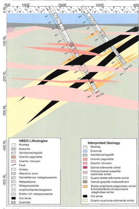
the Fenton Creek Zone into 10 mineralogically and/or geochemically distinct units. The units are (1.) Ordovician dolomite/sandstone/regolith (2.) garnet-sillimanite schist (3.) c1inopyroxene-scapolite-carbonate schist (4.) quartz-biotite-sillimanite schist (5.) garnetiferous-graphititic metasediment (6.) clinopyroxene-biotite/amphibole-plagioclase schist (7.) amphibolite (8) ore lenses (9) quartz-muscovite-sillimanite schist (10.) granitic intrusion and pegmatite. These same divisions were then applied to section 300N and SOON so that correlations between sections could be made (Fig. 3.3, 3.4 &3.5).
3.3.1 Dolomite, sandstone and regolith
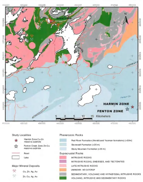
The youngest rocks within the region are the Ordovician dolomites of the Red River and Stony Mountain Formations. The Fenton Creek Zones are located along the boundary between the two formations (Fig. 3.6). The Red River formation is dominated by buff to brown, fine to medium-crystalline fossiliferous dolomite which is generally massive, except for the top of the sequence where it grades into argillaceous dolostone with minor breccia (Fort Garry Member & Herald Formation) (Viljoen et aI., 2000). The Stoney Mountain Formation is another package of dolomites immediately overlying the Red River Formation. It is very similar to the Red River formation, however it is characterised by a lack of fossils and commonly displays nodular bedding instead of the more mottled appearance of the Red River Formation (Viljoen et aI., 2000). Both formations range in thickness from <SSm (Red River Formation) to <35m (Stoney Mountain Formation). The dolomites collected from section 400N of the Fenton Creek Zone consist of massive to weakly vuggy, buff to light brown, mottled fossiliferous (crinoid) dolomites (Fig. 3.7) which range in apparent thickness from 29m to +37m (Fig. 3.4). The upper contact to the unit is an eroded unconformable contact that is overlain by approximately 20m of muskeg. The lower contact is a sharp unconformity with a light brown to grey, variably consolidated-unconsolidated sandstone and regolith.
The sandstone unit varies in thickness from 0 to 5m and consist of buff to grey, variably consolidated weathered sandstone that is occasionally intercalated with minor buff clay seams. The lower contact of this unit is most often gradational with the underlying regolith and is often lost during drilling due to its friable condition. The regolith ranges in thickness from 5 to 20m and is comprised of highly weathered/altered metasediments and intrusive. The lower contact of this unit is also gradational into the coherent units below. The
400E
Chapter3-Local Geology
...J
0:::
0 ' -a
~
I
3f,E . "
19Pf . " .
0:::. • • •
.." ... Y .." ... V." ... Y ..,,!)""
0 ' 1 ' 1 ) to'V D ~'V0 ~'VI)
"--'-' - l
.
\
~2 ,..- #"
1:l-"'~
-
..-.
0:::1 a
0
N
I
'-...-.
o
u
[image:29.594.86.551.50.750.2]u
Figure 3.3 Reconstruction of cross-section 300N using company geological logs and lithogeochemical
control interpreted bythe author (Chapter 5) (modified after data from HBED diamond drill logs and
Iithogeochemical data; internal company report Gilmore et al. 1999)
29
Chapter 3 -Local Geology
-~ 1-"'<ff' Garnet-sillimanite schist eli nopyroxene-scapolite carbonate schist Quartz-biotite-sillimanite schist Garnet-graphite metasediment Biotite-amphibole-plagioclase schist & Amphphibole-clinopyroxene -plagioclase schist Ore lense Quartz-muscovite-sillimanite schist Interpreted Geology ~ MuskegD
Dolomite D Sandstone/regolith D Granitic pegmatite D Granitic intrusion•
DD
o
D•
D
,
,,~«' /' // ////,/,/'
// HBED Lithologieso
Muskeg HI Dolomite ED Sandstone/regolith ~ Granitic pegmatite CJ Granitic intrusion .... " Fault Ed Gniess ~ Alteration zoner;za
Garnetiferous metagreywacke E3 MetasiltstoneEZJ
Metagreywackem
Amphibolite/diorite/gabbro ES] Biotite rich metagreywacke • Ore lense ~ Quartzite-...I 0:::: o o I.{')
I
-...I 0::: o o ~ I
-...I 0:::: o o ...- I
)
o
o
o
o
400E Chapter 3 -Local Geology 300E Garnet-sillimanite schist Cl inopyroxene-scapolite carbonate schist Quartz-biotite-sillimanite schist Garnet-graphite metasediment Biotite-amphibole-plagioclase schist & Amphphibole-c1inopyroxene -plagioclase schist Orelense Quartz-muscovite-sillimanite schist 'Y''Y"'" ",.
·V·V·V·V·V
• b··"V • b "V • " "V' • b "V 0 " Interpreted Geology ~ Muskeg D Dolomite D Sandstone/regolithD
Granitic pegmatiteo
Granitic intrusion•
D
D
Do
•
o
200E / / / / / / 'I'"'I'"'Y''Y ''1'
~"V'V'V'~ b"V
• b"V • b·"V. ",··\V. b·"V. 100E '+'q" 'r q o\'fl V·"r V·"r
V.
tJ'VC> b'Vb-~ .<>«'OE
'r 0 >;' 0 >;' "'I' .."or V ..,:r V,:rV::
r "VI) b'Vl> ~'VD \:oWl) -100E -200E HBED Lithologies E:J Muskeg B3 Dolomite ED Sandstone/regolitho
Granitic pegmatite c:;,] Granitic intrusion .... -Fault D Gniess ~ Alteration zone ~ Garnetiferous metagreywacke E3 Metasiltstonen
Metagreywackem
Amphibolite/diorite/gabbro c:.8 Biotite rich metagreywacke • Ore lense ~ Quartzite--l 0:: o o L()
I
--l 0:: o o '<:TI --l 0:: o o ...- I
-JQPE
o::~>;'.
~.
d
~."V.
b • f)l.ltO~ Figure 3.5 Reconstruction of x-section SOON using company geological logs and lithogeochemical control interpreted by the author (Chapter 5)(modified after data from HBED diamond drill logs and lithogeochemical data; internal company report Gilmore et aL 1999)~)
()
o
o
o
'---' '....,) II -".-;. I
+
l~v
I
~
0
"-..J'
~
+(/
gL0
e
+
+r>
)+
\+
+
0 , ~
J
FentonCK.
' - ~Lr ;...,
/
+
~-+
FENTON ZONEHARM-J-N ZONE"*
*
-...J I J 5 0 5 10 15 Kilometers
I I
i i I i I i i i
410000 420000 430000 440000 450000 460000 470000 480000
Chapter3-Local Geology
470000 480000
! !
{J
-'
"-.; I~. -Y IIj j"-~~~ M ~ N
4
A+
gCP
~,
o~
-(IV·'
~ 8• • " './1"] .:.i
~/))'
'; . • .-
,~1:t -" ,
. ~ ,~' j
~ . ,
-
.
. . . , .
\ 8
+
~ o-#'+
8
I 0
~~)
--i}0
L
r
"'-
~/
'I~~
~
.J
1.I
+
+
8I C51~ j - l\._m. " l r
..
~ (,
'
-Study Localities Phanerozoic Rocks
',-
*:
Harmin Zone Cu-Zn massive sulphide Fenton Creek Zone Zn-C u massive sulphide
Red River Formation (Heraldand Yeoman formations) «SSm)
Stonewall Formation (<25 m) Stony Mountain Formation «35 m)
Major Mineral Deposits Road
c::=J
LakeSupracrustal Rocks INTRUSIVE ROCKS
'X'
'X'
Cu, Zn, Ag, Au
Zn, Cu, Ag, Au
-INTRUSIVE ROCKS, GNEISSES, AND TECTONITES LATE I NTRU SI VE ROCKS
UNKNOWN - NO OUTCROP
SEDIMENTARY, VOLCANIC AND HYPABYSSAL INTRUSIVE ROCKS VOLCANIC, INTRUSIVE AND SEDIMENTARY ROCKS
[image:32.594.87.556.52.648.2], - /
Figure 3.6 Local geology of Fenton Creek zone showing the extent of the Phanerozoic dolomitic cover rocks (modified after data from Natmap Shield Margin Project Working Group, 1998)
~/
'---'
Chapter3-Local Geology
~
~
''--.--
''
'
-"----"
tHI
__
~=~===============-i--r- - ,
."::"i 11 t
'---'
,
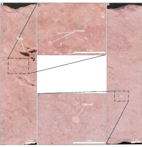
'-...-. Figure 3.7 - Fossiliferous dolomite cover rock
~
'-...-
'---A) Vuggy and mottled fossiliferrous dolomite inferred from regional geology map to have come from the Ordovician Stoney Mountain formation. Sample 75666H from drill hole Har044 (35m)
B) Close-up view of sample 75666H showing criniod stems and small pin sized solution vugs .
[image:33.594.93.550.53.526.2]"----
',--"--....
"-~
'--.--
'---"--./
[image:34.594.85.551.53.575.2]"--Chapter3-Local Geology
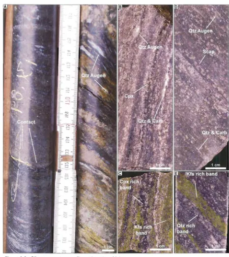
Figure 3.8 - Clinopyroxene-scapolite-carbonate schist
A) Photograph showing the lower contact of the clinopyroxene-scapolite-quartz-carbonate schist with sheared and clay altered quartz(Qtz)-biotite(Biot)-sillimanite(sill) schist. Drillhole Har044 (131.81 m).
B.} Clinopyroxene(Cpx}-scapolite(Scap}-carbonate(Carb} schist showing strong banding and segregation of the clinopyroxene from quartz and carbonate. Sample H25874 drillhole Har044 (81.30m).
C.} Clinopyroxene-scapolite-carbonate schist stained for K-feldspar (Kfs) (yellow). Sample H25874 drillhole Har044 (8i.30m).
0) Similar to sample H25852 with less quartz &carbonate but increased scapolite giving the sample a pale green color from
sample H25875 drillhole Har044 (92.70m)
,~
Chapter3-Local Geology
thickness of dolomite in conjunction with sandstone and muskeg make this package of rocks a formidable barrier to conventional exploration methods.
3.3.2 Garnet-sillimanite schist
The garnetiferous-sillimanite schist forms the upper most stratigraphic unit intersected on the Fenton Creek property it occurs below the overburden and Ordovician dolomite/ sandstone. Company geologists logged this unit as a garnetiferous metagreywacke and "anatexis metagreywacke". Separation and distinction of this unit from other metagreywackes in the stratigraphy has been based on mineralogical and geochemical discrimination (Chapter 5). Major intersections of this unit occurring in diamond drill holes Har031 and Har041 along section 50
ON
suggest that it is >120 m thick and dips 40-45° W (Fig. 3.5). Unfortunately no samples of this unit were available for detailed study, however, the unit as described in diamond drill logs consists of a poor to well foliated metagreywacke-anatexis with 12-17% garnet porphyoblasts, minor amounts of graphite and trace sillimanite occurring parallel to the foliation. The logged descriptions also mention numerous pegmatite and granitic intrusions as well as quartz sweats and a fair amount of partial melting indicating anatexis.3.3.3 Clinopyroxene-scapolite-carbonate schist
The clinopyroxene-scapolite-carbonate schist occurs immediately below the garnet-sillimanite schist. Identification of the clinopyroxene-scapolite-carbonate schist was made using logged mineralogy and geochemistry (Chapter 5). Company geologists logged this unit as a calc-silicate altered quartzite to metasiltstone. Major intersections of this facies occurring in diamond drill holes Har031, Har041 and Har044 suggest that it has an apparent thickness of 40-60m and dips 40-45° W (Fig. 3.4 & 3.5). Clinopyroxene-scapolite-carbonate schist dominates the unit, though minor amounts garnet-graphite metapelite and calc-silicate altered siltstone/metagreywacke (from the geologic logs) have also been noted. From the diamond drill logs the upper and lower contacts for this unit are often truncated by intrusions or faults, as is the case in diamond drill hole
Har044 where the lower contact is relatively sharp (Fig. 3.8A).
In hand specimen this rock is composed of a grey to light green, medium grained schist with alternating bands of quartz, carbonate, k-feldspar and clinopyroxene (diopside??) (Figs. 3.8B and 3.8D). Bands vary in thickness from 0.25 to 1cm and may represent bedding (So), which are thought regionally to be parallel to S1 foliation. Most samples
",,--'
'
..
.~
'-
"
-Chapter3-Local Geology
are strongly foliated and are marked by the occasional quartz augen as shown in (Fig. 3.8 B&O).
In thin section this rock is composed of a granoblastic mosaic of 15-25% clinopyroxene (diopside), 10-20% scapolite, 10-20% K-feldspar, 10% quartz, 10% amphibole, 5-10% carbonate occurring as alternating domains of k-feldspar, clinopyroxene and quartz-scapolite-carbonate rich bands (Fig. 3.9). Accessory minerals include, 3-5% sphene occurring as sub-rounded to subangular blebs and crystals and 1-2% pyrrhotite and trace chalcopyrite.
The mineralogy of this unit, including the clinopyroxene, amphibole and sphene association, together with the granoblastic textures of this unit are consistent with an upper amphibolite to granulite facies metamorphosed rock of probable basic igneous origin. The occurrence of scapolite may indicate the presence of a CO2. and CI-rich solution; however further detailed research is required to confirm such a claim. Unfortunately, much if not all of the minerals have been recrystallised into coarser grains and in that process destroyed the original textures of this rock unit.
3.3.4 Quartz-biotite-sillimanite schist
The quartz-biotite-sillimanite schist occurs as a +300m thick stratiform unit predominantly in the hanging wall to the mineralised lenses and is intersected in all diamond drill holes except Har01 0 and Har016 of the sections studied (Fig. 3.4). Though this unit dominantly occurs in the hanging wall of the deposit, other occurrences have been noted in the footwall of the deposit. Previous logging by HBEO geologists have identified this unit as a variably altered metagreywacke. As with the previously described clinopyroxene-scapolite-carbonate skarn; geochemistry and mineralogy was employed to help discriminate the quartz-biotite-sillimanite schist from other HBED logged metagreywackes (Chapter 5). The unit is dominated by quartz-biotite-sillimanite schist with minor interbedded garnet-graphite metapelite and amphibole-biotite schist. The contacts for this unit are almost always sharp with the granitic intrusions and often gradational with other units in the stratigraphy (Fig. 3.1 OA).
In hand specimen this rock is often light to dark grey, fine to medium grained, with a mottled, coarse clastic texture that is parallel to the foliation. These pseudo-clasts range in size and degree of roundness but are generally 1-2 em in diameter. At hand specimen scale this rock is characterised by quartz augens and wispy sillimanite
'---v
''"=-
'--\...,
'--
',,-'-.-'
'---'
'---'---'
o
Chapter3-Local Geology
A) Granoblastic mosaic of fine grained quartz(Qtz) and k-feldspar(Kfs) with coarser grained scapolite(Scap). Sample H25852 (1.25x magnification, crossed nichols).
B) Granoblastic mosaic of fine grained carbonate(Carb) with coarser grained scapolite(Scap). Sample H25852 (5x magnification, crossed nicols).
C) Granoblastic mosaic of quartz(Qtz) and scapolite(Scap) and twinned subhedral clinopyroxene (Cpx) grain. Sample H25852 (5x magnification, crossed nicols).
D) Intergrowth of colorless clinopyroxene(Cpx) and green amphibole(Amp) with 100ilm subhedral sphene crystals. Sample
H25852 (5x magnification, plane polarized light).
E) High relief clinopyroxene and brown sphene crystals in granoblastic mosaic of quartz, scapolite and carbonate. Sample H25852 (5x magnification, plane polarized light).
F) Disseminated sulphides of intergrown pyrrhotite(Po) and chalcopyrite(Cpy). Sample H25852 (20x magnification, reflected light).
G
"---"
~
L
v
~
~
~
,---../
'---.-/
'-o
u
Fig ure 3.10 Various examples quartz-biotite-sillimanite schist
A) Sharp conformable contact of the quartz(Qtz)-biotite(Biot)-sillimanite(Sill) schist with quartz(Qtz)-feldspar(Fs)-carbonate(Carb) psammite. Sample H25881 drill hole Har044 (194.70m).
B) Typical quartz(Qtz)-biotite(Biot)-sillimanite(Sill) schist showing mottled psuedo clastic textures. Sample H25853 drillhole Har043 (132.50m).
C) Quartz(Qtz)-biotite(Biot)-sillimanite(Sill) schist showing the distribution of K-feldspar(Kfs)
(stained yellow). Sample H25853 .
0) Late stage quartz vein through mottled moderately foliated
quartz(Qtz)-biotite(Biot)-sillimanite(Sill) schist. Sample G35271 drillhole Har018 (85.80m).
E) K-feldspar staining of sample G35271 including the late stage quartz vein showing halo effects of potassium rich fluid associated with the vein.
F) Biotite rich example of the quartz(Qtz)-biotite(Biot)-sillimanite(Sill) schist showing strong foliation with development of quartz augen and minor sillimanite. Sample F70402 drillhole Har021 (137.40m).
G) Sillimanite rich example of the quartz(Qtz)-biotite(Biot)-sillimanite(SiII) schist showing wispy
sillimanite and biotite aligned parallel to the foliation. Sample H25889 drillhole Har044 (418.23m).
Chapter3-Local Geology
clots parallel to a moderately well developed foliation at 20-30Qto core axis. Discernable
mineralogy consists of quartz, plagioclase, K-feldspar (by staining), biotite and sillimanite (Fig. 3.1 OB-E).
In thin section this rock generally is seen to be comprised of a granoblastic mosaic of 40-50% irregularly shaped 0.3-1.5mm quartz grains, 10-30% brown 0.3-0.5mm elongate biotite lathes, 5-15% 0.3-1.5mm weakly altered plagioclase, 10-20% 1-5mm slender elongate sillimanite crystals which are most often aligned with foliation, and 1-3% <0.5mm irregularly shaped muscovite/sericite crystals. Accessory minerals include, 1-3% K-feldspar and trace cordierite (Fig. 3.11).
The mineralogy of this unit, including the quartz, biotite, plagioclase and sillimanite, suggest that this unit is likely of probable acid igneous origin. As with most units from the Fenton Creek zone the metamorphic grade has destroyed many of the primary textures. The quartz-biotite-sillimanite schists do however, display a mottled texture that is also seen in the quartz-muscovite-sillimanite schist but absent from the other units in the Fenton Creek stratigraphy. This texture may indicate a coarser volcaniclastic rock or may simply reflect compositional differences in the original rock.
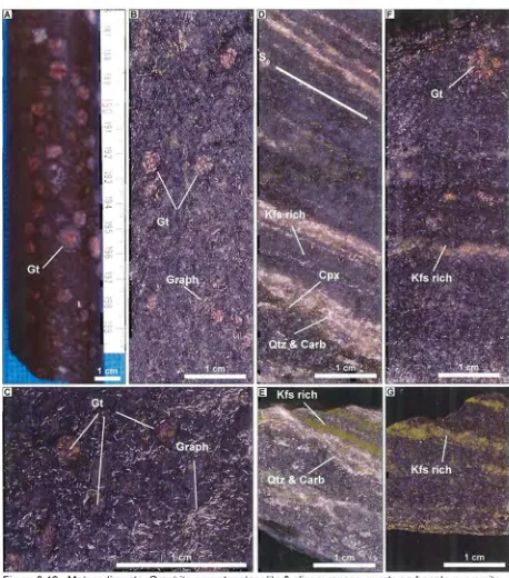
3.3.5 Garnetiferous-graphitic metasediment
The garnetiferous-graphitic metasediment occurs as semi-continuous, 1-5m horizons within and around the massive sulphide lenses and as a large 10-25m thick continuous horizon dipping 40-45QWand located high in the hanging wall to the mineral lenses
(Fig. 3.4). The unit as defined in the hanging wall consists of 1-5m horizons of garnet-graphite metapelite interbedded with a 15-20m thick quartz-carbonate-feldspathic psammite.
In hand specimen the garnet-graphite metapelite is fine to medium grained, dark brown to black metamorphic rock. The matrix of the metapelite is comprised of fine-grained biotite and small <1 mm long acicular graphite crystals that appear to grossly wrap around porphyroblasts. The porphyroblasts consist 0.25 to 1em subhedral pink garnets that appear dispersed throughout the sample with other almost undiscernible, unidentified porphyroblasts (Fig. 3.12A-C). Further photographs of the mineralised garnetiferous graphitic metapelite are shown in Figure 6.3.
In thin section the metapelite is consists of a variable granoblastic mosaic of 30-40%, subhedral, 0.2-0.75mm quartz grains; 20-30%, 0.3-1mm, fresh plagioclase; 10-20%,