Visualising social space: Investigating
the use of space and human-animal
interaction in Neolithic built
environments in the Zagros Mountains
and adjacent lowlands.
Thesis submitted in accordance with the requirements of the University of Liverpool for the degree of Doctor in Philosophy by
Cecilie Lelek Tvetmarken.
i
Abstract
The Neolithic in the Near East witnessed increased duration of settlements and the emergence of food production. Research has in recent decades become increasingly focused on the social mechanisms that underpinned these developments. There has been considerable debate about the extent to which Neolithic built environments reflect new forms of social relationships, household composition and interaction, and the degree to which these may be linked to new economic practices. Most discussions have, however, focused on the Levantine record as it presents a more comprehensive data set. Despite the increase in fieldwork taking place in the Zagros and adjacent lowlands since the late 1990s, there are still temporal gaps in our understanding of the transition from mobile hunter-gatherer groups to more sedentary communities in this area. Additionally, discussions have tended to focus on the reconstruction of economic strategies, and especially the question of caprine domestication, with little consideration of the social transformations that took place in this area. The main aim of this thesis is therefore to begin to redress this situation by providing a contextualised examination of social practices within Neolithic communities in the central and northern parts of the Zagros Mountains and adjacent lowlands.
The methodology employed in this thesis utilises a computer-based modelling approach that allows us to visualise architectural remains as lived-in spaces by considering how people lived within and utilised the built environment. Various scenarios were modelled to assess the physical affordance of space for human occupancy, different scales of social interactions and activities associated with daily life, human-animal interaction, and potential storage capacities. This facilitated an examination of how the structuring and use of space may reflect the social practices that existed within individual communities.
ii
Acknowledgments
There are many people who have contributed to my thought process throughout the writing of this thesis. First and foremost I would like to express my sincere gratitude to my supervisors, Prof. Douglas Baird and Dr. Matthew Fitzjohn, for their continuous guidance, encouragements, and insights over the past four years. This thesis would not have been possible without their support and advice throughout.
I would also like to offer my thanks to Dr Rachel Pope and Dr Jessica Pearson for their encouragements and discussions on aspects of my research. Special thanks must also go to Rachel Heslop and Samantha Cook for their continuous support and for reading and commenting on various drafts of this thesis. I would also like to thank my friends and colleagues Dr. Nick Taylor, Dr. Corisande Fenwick, Rhw Mitcheson, Nick Wernick, Rosa Campos-Blade, Beliz Tecirli, Rachael Brown, Dr. Holly Miller, Lucy Bennison-Chapman, Francoise Rutland, Ceren Kabukcu, Caroline Middleton, Martina Keller, Tim Wakeford, John Stewart, Nicky Nielsen, Christine Schepens, Banjo Patterson, Rosie Patterson, Joe Skinner, Anke Marsh, Andy Shuttleworth, and Mari Dragland Gjersvoll for their continuous support, advice, stimulating discussions, as well as keeping me sane throughout.
iii
Table of Contents
Abstract...i
Acknowledgements...ii
Table of Contents...iii
List of Figures in main text...viii
List of Tables in main text...xiii
Appendices: List of Figures and Tables...xv
Chapter 1 Introduction 1.1: Introduction...1
1.2: Thesis structure...6
Chapter 2 Archaeological background 2.1: Introduction...8
2.2: Environmental setting...9
2.3: The development of plant cultivation and animal herding...12
2.3.1: The Levant and southeast Anatolia...14
2.3.2: The Zagros...17
2.4: Settlements, architecture and households...24
2.5: Ritual practices...31
2.6: Summary...33
iv
3.2: Defining spaces within the built environment...37
3.3: Scenario modelling...38
3.3.1: Modelling co-residency...41
3.3.2: Modelling co-presence...47
3.3.3: Activities and social interactions...48
3.3.4: Animals within the built environment...50
3.3.5: Modelling storage...55
3.3.6: Modelling the storage of fodder...59
3.4: Summary...63
Chapter 4 Ganj Dareh 4.1: Introduction...65
4.2: The excavations...66
4.3: Summary of the excavation results...68
4.4: Modelling scenarios...72
4.4.1: Contextualised maximum capacity...73
4.4.2: Modelled activities...78
4.4.3: Potential storage capacity...83
4.4.4: Access and movement between spaces...89
4.4.5: Possible reconstructions of the upper storeys...91
4.5: Summary...94
Chapter 5 Qala’at Jarmo 5.1: Introduction...98
5.2: The excavations...99
5.3: Structural remains in Trench I...101
5.4: Structural remains in Trench II...104
v
5.5.1: Trench I, Level 7...108
5.5.1.1: Contextualised maximum capacity...109
5.5.1.2: The use of space...112
5.5.2: Trench I, Level 6d-b...114
5.5.2.1: Contextualised maximum capacity...115
5.5.2.2: The use of space...117
5.5.3: Trench I, Level 6a...119
5.5.3.1: Contextualised maximum capacity...121
5.5.3.2: The use of space...121
5.5.4: Trench II, Level 5...122
5.5.4.1: Contextualised maximum capacity...124
5.5.4.2: The use of space...127
5.6: Storage capacity...130
5.7: Summary...134
Chapter 6 Hajji Firuz 6.1: Introduction...138
6.2: The excavations...139
6.3: Summary of excavation results...142
6.3.1: Phases L-E...144
6.3.2: Phase D...147
6.3.3: Phase C...149
6.3.4: Phase B...152
6.3.5: Phase A3...153
6.4: Modelling scenarios...156
6.4.1: Contextualised maximum capacity...158
6.4.2: The use of space...167
6.4.2.1: Phases J-E...170
vi
6.4.2.3: Phase C...176
6.4.2.4: Phase B...179
6.4.2.5: Phase A3...180
6.4.3: Modelled potential storage...183
6.4.4: What about animals?...190
6.5: Summary...194
Chapter 7 Sheikh-e Abad, Ali Kosh, Nemrik and Magzaliyah 7.1: Introduction...198
7.2: The Zagros Mountains and lowlands of southwest Iran...199
7.2.1: Sheikh-e Abad...200
7.2.2: Ali Kosh...204
7.3: The lowlands of northern Iraq...212
7.3.1: Nemrik 9...212
7.3.1.1: The built environment...216
7.3.1.2: The structuring and use of space...222
7.3.2: Magzaliyah...233
7.3.2.1: The Architecture...235
7.3.2.2: The structuring and use of space...238
7.4: Summary...245
Chapter 8 The structuring of space in Neolithic settlements 8.1: Introduction...249
8.2: The structuring of social space...250
vii 9.2: Future avenues of research...263
Appendices
Appendix A: Archaeological Background (Chapter 2)...268
Appendix B: Methodology (Chapter 3)...272
viii
List of Figures in main text
2.1 Map of Neolithic sites in the Zagros highlands and adjacent lowlands
mentioned in the text. 23
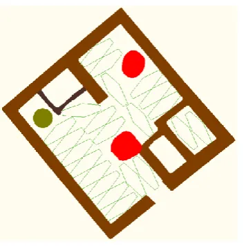
3.1 Modelled contextualised maximum capacity for sleeping in Structure II1. Note the limited amount of space available for the two modelled
individuals in the smallest space. 45
4.1 Overall site plan of Ganj Dareh showing locations of excavated trenches with the location of the level D remains used for the scenario modelling
outlined in red (modified from Merrett 2004: fig. 9.1). 67
4.2 Plan of level D at Ganj Dareh with space numbers. 72
4.3 Modelled maximum capacities of Size A (left) and Size B (right) adults
sitting cross-legged (top) and sleeping (bottom). 76
4.4 Modelled capacity for goats in S12 and S28. 77
4.5 Modelled maximum capacities of Size A (left) and Size B (right) adults
squatting (top) and kneeling (bottom). 82
4.6 First reconstruction of upper storey; modelled maximum capacities of Size A (left) and Size B (right) adults sitting cross-legged (top) and sleeping
(bottom). 92
4.7 Second reconstruction of upper storey; modelled maximum capacities of Size A (left) and Size B (right) adults sitting cross-legged (top) and
sleeping (bottom). 93
4.8 Third reconstruction of upper storey; modelled maximum capacities of Size A (left) and Size B (right) adults sitting cross-legged (top) and
sleeping (bottom). 93
4.9 Fourth reconstruction of upper storey; modelled maximum capacities of Size A (left) and Size B (right) adults sitting cross-legged (top) and
sleeping (bottom). 94
5.1 Overall site plan of Jarmo showing locations of excavated trenches with the location of trenches I and II outlined in red (modified from Braidwood
ix
5.2 Plan of level 7 with space numbers. 109
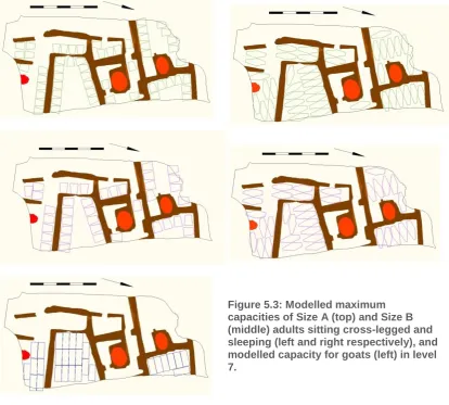
5.3 Modelled maximum capacities of Size A (top) and Size B (middle) adults sitting cross-legged and sleeping (left and right respectively), and
modelled capacity for goats (left) in level 7. 112
5.4 Plan of level 6b-d with space numbers. 115
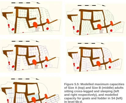
5.5 Modelled maximum capacities of Size A (top) and Size B (middle) adults sitting cross-legged and sleeping (left and right respectively), and
modelled capacity for goats and fodder in S4 (left) in level 6b-d. 117
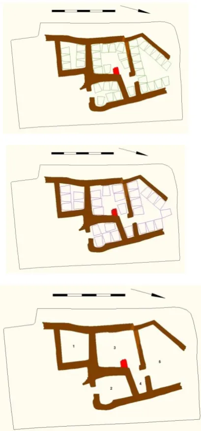
5.6 Plan of level 6a with numbered spaces (bottom left). Also showing modelled maximum capacities of Size A (top) and Size B (middle) adults
sitting cross-legged and sleeping (left and right respectively) in level 6a. 120
5.7 Plan of the earliest (left) and latest (right) phase of level 5 with space
numbers. 123
5.8 Modelled maximum capacities of Size A (top) and Size B (middle) adults sitting cross-legged and sleeping (left and right respectively), and
modelled capacity for goats (bottom left) in the earliest phase of level 5. 126
5.9 Modelled maximum capacities of Size A (top) and Size B (middle) adults sitting cross-legged and sleeping (left and right respectively) for Structure
A in the latest phase of level 5. 128
6.1 Overall site plan showing the locations of the excavated trenches with the trenches from which the structural remains discussed in this chapter
outlined in red (modified from Voigt 1983: fig. 5). 140
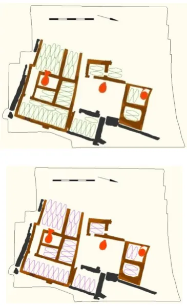
6.2 Plans of the structural remains found in phases K2 through E. 145
6.3 Plan of the structural remains found in Phase D. 148
6.4 Plan of the structural remains found in Phase C. 150
6.5 Plan of the structural remains found in Phase B. 152
6.6 Plan of the structural remains found in Phase A3. 155
6.7 Modelled maximum capacities of Size A and Size B adults sitting cross-legged (left) and sleeping (right) in the earliest and latest phases of phase
A3 (top two and bottom two respectively). 161
6.8 Modelled maximum capacities of Size A and Size B adults sitting cross-legged (left) and sleeping (right) in phases B and C (top two and bottom
two rows respectively). 162
6.9 Modelled maximum capacities of Size A and Size B adults sitting
x 6.10 Modelled maximum capacities of Size A and Size B adults sitting
cross-legged (left) and sleeping (right) in phase E and phase F1 (top two and
bottom two rows respectively). 165
6.11 Modelled maximum capacities of Size A and Size B adults sitting cross-legged (left) and sleeping (right) in phase G and phase H1 (top two and
bottom two rows respectively). 166
6.12 Modelled maximum capacities of Size A and Size B adults sitting cross-legged (left) and sleeping (right) in phase H2 and phase J (top two and
bottom two rows respectively). 167
6.13 Modelled activities in phases E-J. 172
6.14 Modelled activities in phase D. 174
6.15 Modelled activities in phase C. 178
6.16 Modelled activities in phase B. 180
6.17 Modelled activities in the early (top) and late (bottom) phases of phase A3. 183
6.18 Possible configuration of on-floor storage and work space in S2 in
Structure II1, phase A3 (top), and affordance of space for co-residency and storage in phase C (middle left) and phase D (middle right); and modelled on-floor storage of grain (bottom left) and fodder (bottom right) in Structure
VII in phase D. 187
6.19 Modelled affordance of space for co-residency, storage and goats in the earliest and latest phases of phase A3 (top right and left respectively),
phase B (middle left), phase C (middle right), and phase D (bottom left). 188
6.20 Modelled affordance of space for co-residency, storage and goats in phase E (top left), phase F1 (top right), phase G (bottom left) and phase
H2 (bottom right). 189
6.21 Modelled affordance of space for goats in external areas. 192
7.1 Overall site plan of Sheikh-e Abad showing location of the main trench
outlined in red (modified from Matthews et al 2009: fig. 3.6). 200
7.2 Modelled maximum capacities of Size A and Size B adults sitting cross-legged (top) and sleeping (middle); affordance of space for goats (bottom left); and modelled co-residency and storage (bottom right) at Sheikh-e
Abad. 201
7.3 Overall site plan for Ali Kosh showing the locations of the excavated trenches with the trench in which the Bus Mordeh and Ali Kosh phase remains discussed in this chapter outlined in red (modified from Hole, Flannery and Neely 1969: fig. 4).
xi 7.4 Modelled maximum capacities of Size A and Size B adults sitting
cross-legged (top) and sleeping (middle); affordance of space for goats (bottom left); and modelled co-residency and storage (bottom right) in the Bus
Mordeh phase. 208
7.5 Modelled maximum capacities of Size A and Size B adults sitting cross-legged (top) and sleeping (middle); affordance of space for goats (bottom left); and modelled co-residency and storage (bottom right) in the Ali Kosh
phase. 211
7.6 Overall site plan of Nemrik showing the location of the excavated trenches. The white trenches (A on the bottom left key) are shallow trenches, the shaded trenches (B on the bottom left key) are deep trenches, and the black trench (C on the bottom left key) is the 80 m long
N-S trench (modified from Kozłowski 2000: fig. 7). 213
7.7 Settlement layout in phases IVb and V (left and right respectively) showing buildings(with structure numbers), outline of pavement, areas containing ground stones (striped areas), the refuse pit in phase V, and the external
burial area in phase IVb (purple outline). 221
7.8 Modelled maximum capacities of Size A (top) and Size B (middle) adults sitting cross-legged and sleeping (left and right respectively); and
modelled co-residency and storage (left) in Structure 1B. 224
7.9 Modelled maximum capacities of Size A and Size B adults sitting cross-legged (top) and sleeping (middle); modelled co-residency and storage (bottom left); and the impact on co-residency and storage if activity areas
were not used for storage or sleeping (right) in Structure 1A. 225
7.10 Modelled maximum capacities of Size A (top) and Size B (middle) adults sitting cross-legged and sleeping (left and right respectively), and
modelled co-residency and storage (left) in Structure 1. 226
7.11 Modelled maximum capacities of Size A (top) and Size B (middle) adults sitting cross-legged and sleeping (left and right respectively), and
modelled co-residency and storage (left) in Structure 2. 227
7.12 Modelled maximum capacities of Size A (top) and Size B (middle) adults sitting cross-legged and sleeping (left and right respectively); and
modelled co-residency and storage (left) in Structure 3. 228
7.13 Modelled maximum capacities of Size A (top) and Size B (middle) adults sitting cross-legged and sleeping (left and right respectively); and
modelled co-residency and storage (left) in Structure 10. The bottom right plan shows the location of the burials and the portable ground stones
found within the building. 230
7.14 The Phase V occupation with modelled affordance of space for goats. Each block of blue represents 100 goats (due to scale individual goats do
xii 7.15 Overall site plan of Magzaliyah showing the location of the excavated
trenches (black boxes) with the location of the structural remains used in the scenario modelling outlined in red (modified from Bader 1993a: fig. 2.1). Structure A is located in grid squares K6, L6, M6, J7, K7, L7, M7, J8, K8, and L8; and Structure B is located in grid squares K7, L7, M7, K8, L8,
and M8. 234
7.16 Structure A (left) and Structure B (right) with space numbers. 236
7.17 Modelled maximum capacities of Size A (left) and Size B (right) adults
sitting cross-legged (top) and sleeping (bottom) in Structure A. 239
7.18 Modelled maximum capacities of Size A (left) and Size B (right) adults
sitting cross-legged (top) and sleeping (bottom) in Structure B. 241
7.19 Modelled capacity for goats (left), and co-residency and storage (right) in
xiii
List of Tables in main text
3.1 Comparison between calculated floor area per person, average household size, and scenario modelling for the early phase of Structure II1 at Hajji
Firuz, which has a 28 m2 roofed floor area. 45
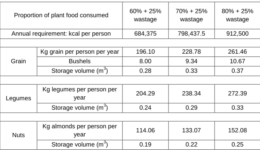
3.2 Calculated storage volume for storing the annual calorific requirement for one person if supplied by grains, legumes and nuts. 57
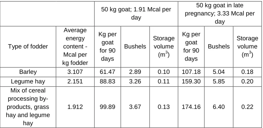
3.3 Feed requirements for 50 kg goat and 50 kg pregnant doe for 90 days. 61
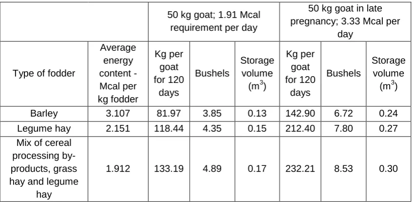
3.4 Feed requirements for 50 kg goat and 50 kg pregnant doe for 120 days. 62
4.1 Modelled contextualised maximum capacities. 74
4.2 Modelled contextualised maximum capacities of adults squatting and
kneeling in the small space. 81
4.3 Potential storage capacities of bins and some of the smallest spaces. 84
4.4 Potential storage capacities of clay vessels. 85
4.5 Potential storage capacities of bins and some of the smallest spaces. 86
4.6 Potential capacities of bins and clay vessels storing food for human
consumption. 87
4.7 Potential capacities of small spaces for storing animal fodder. 88
4.8 Approximate sizes of portholes. 89
5.1 Modelled contextualised maximum capacities for level 7. 110
5.2 Modelled contextualised maximum capacities for level 6d-b. 116
5.3 Modelled contextualised maximum capacities for level 6a. 121
5.4 Modelled contextualised maximum capacities for level 5. 125
5.5 Potential on-floor storage capacities for small spaces. 131
xiv 5.7 Potential capacities for storing animal fodder (90 days) in small spaces. 132
5.8 Size of potential co-resident unit and the potential storage capacities for
storing food and fodder in each level. 133
6.1 Architectural sequence at Hajji Firuz. 141
6.2 Modelled contextualised maximum capacities. 159
6.3 Potential storage capacities for small spaces. 184
6.4 Potential built-in storage capacities for buildings discussed in this chapter. 186
6.5 Potential capacities of small spaces for storing animal fodder. 190
6.6 Modelled capacities for goats in external spaces. 193
7.1 Potential storage capacity, Sheikh-e Abad. 202
7.2 Modelled contextualised maximum capacities, Bus Mordeh phase. 207
7.3 Modelled contextualised maximum capacities, Ali Kosh phase. 210
7.4 Stratigraphy at Nemrik. 215
7.5 Modelled contextualised maximum capacities at Nemrik. 222
7.6 Modelled contextualised maximum capacities at Magzaliyah. 238
7.7 Potential storage capacities of small spaces, bins and pits. 244
8.1 Summary of architectural forms and internal features at each site. 251
8.2 Suggested ranges of possible co-resident individuals in potential living
spaces and/or domestic structures. 253
8.3 Comparison of methods for estimating size of co-resident units. 254
8.4 Summary of the location of food-related and manufacturing activities at
each site. 256
8.5 Potential storage capacity and affordance of space for animals within each
xv
Appendices: List of Figures and Tables
Figure Table
Chapter 2 Appendix A
2.2 Neolithic sites mentioned in the text. 268
2.3 Palaeolithic and Epipalaeolithic sites mentioned in the text. 268
2.1 Mean annual temperatures (°C) recorded for a selection of cities
in the Zagros Mountains and adjacent lowlands. 269
2.2 Mean annual precipitation (all in mm) recorded for a selection of cities in the Zagros Mountains and adjacent lowlands. Includes
rain and snow. 271
Chapter 3 Appendix B
3.2 Conventions used in the modelling. 272
3.3 Polygons and measurements for the Size A adult. 273
3.4 Polygons and measurements for the Size B adult. 274
3.5 Polygon and measurements for the modelled goat. 275
1
Chapter 1
Introduction
1.1: Introduction
Ever since Gordon Childe postulated that the ‘Neolithic Revolution’ was the first pivotal economic and cultural transformation in human prehistory (Childe 1941), the origins and establishment of agricultural economies has been a major focus in research on the Neolithic in the Near East (Asouti 2006; Byrd 2005a; Kuijt and Goring-Morris 2002 and references therein). Robert Braidwood’s Iraq-Jarmo Project in the Zagros foothills of Iraq, initiated in 1947, was the first interdisciplinary fieldwork project that systematically attempted to investigate the Neolithic period (Braidwood 1973). The project marked the beginning of a new focus in the archaeology of the Near East, which up until then had been primarily concerned with chronological issues and the acquisition of museum pieces (Braidwood 1972: 310; Wright 1971: 447-9). Braidwood subsequently conducted fieldwork in the Kermanshah Valley in central Zagros, western Iran
(
Braidwood 1960, 1961; Braidwood, Howe and Reed 1961), which stimulated the initiation of other archaeological projects focusing on the Neolithic in the Iranian Zagros (Young 1987: 287), e.g. at Tepe Guran (Meldgaard, Mortensen and Thrane 1963), Ganj Dareh (e.g. Smith 1976, 1990), Hajji Firuz (Voigt 1976, 1983), Ali Kosh (Hole and Flannery 1962, 1967; Hole, Flannery and Neely 1969), and Tepe Abdul Hosein (Pullar 1981, 1990).2 Kozlowski and Aurenche 2005: 20; Zeder 2009: 14).1 This situation has started to change with an increase in the number of archaeological projects taking place in Iran since the late 1990s (Azarnoush and Helwing 2005: 189) with local and foreign archaeologists undertaking (often collaborative) projects in various parts of the country (e.g. Darabi and Fazeli 2009; Matthews et al 2010; Potts et al 2005; Potts et al 2009; Tsuneki, Zeidi and Ohnuma 2007; Weeks et al 2006). However, there are still temporal gaps in our knowledge concerning the transition from mobile hunter-gatherer groups to more sedentary communities, especially in the upland zones of the Zagros (Hole 1996: 263-268), and most models aimed at explaining the developments that took place during the Neolithic have been constructed based on more substantial data sets from the Levant (see Asouti 2006 and references therein).
The increased duration of settlements from the Late Epipalaeolithic through the Early Neolithic tends to be viewed as a region-wide phenomenon characterised by a shift from temporary circular or oval hut structures to larger rectangular, often multi-roomed buildings. Plant cultivation and herding of animals began sometime during this period, resulting in increased reliance on domestic crops and animals and an eventual decrease in exploitation of wild resources. Archaeological research was initially concerned with the technological and economic aspects of this transition, especially pinpointing the location and timing of the domestication of plants and animals (Kuijt 2000a). In recent decades attention has turned to the social mechanisms that underpinned the developments that took place (Asouti 2006: 98; Kuijt 2000b, 2000c), focusing on issues such as household composition and organisation, social differentiation, competition, and ritual behaviour (Bender 1978; Byrd 1994, 2000, 2005b; Flannery 1972, 2002; Kuijt 1995, 2000b: vii, 2000c: 311-315, 2000d, 2000e; Watkins 2002: 41; see various contributions in Gebel, Hermansen and Jensen 2002; Kuijt 2000f). Settling down and dwelling within permanent settlements would have affected the ways in which people related to and interacted with each other (Banning 2003: 5; Wilson 1988: 4, 9-10); one of the ways that people manage social relationships within sedentary communities is through the construction of architectural structures, as these spatially mark out and direct social interaction (Marshall 2006: 160). In this sense, the built environment facilitates particular forms of understanding and actions (Boyd 2006: 171). Architecture and the use of space are therefore central features in the investigation of issues such as sedentism, social organisation, community structure, and household composition (e.g. Byrd 2000, 2005b; Flannery 1972; Cutting 2005; Düring 2006; Verhoeven 1999).
Archaeologists have recorded a range of regional variations in vernacular architectural traditions during the Epipalaeolithic and Neolithic. In the Levant structures were circular or oval, some with internal features such as post holes for roof support, hearths, sub-floor burials, and/or shallow stone-filled basins or depressions during the Epipalaeolithic (Goring-Morris and Belfer-Cohen 2008: 244-250). In the subsequent Pre-Pottery Neolithic A (PPNA)
1
3 buildings were oval, semi-subterranean, made of stone, tauf/chineh2, or mud bricks, and occasionally had post holes for support posts, internal dividing walls, hearths, limestone slabs with cupholes set into the floor, and external silos (Goring-Morris and Belfer-Cohen 2008: 254; Kuijt and Goring-Morris 2002: 737). During the transition to the Pre-Pottery Neolithic B (PPNB), structures became rectilinear, were made of mud bricks and/or stone with plastered floors and walls, many had multiple internal spaces and some an upper storey (Goring-Morris and Belfer-Cohen 2008: 261; Kuijt and Goring-Morris 2002: 392, 407). In southeast Anatolia and along the western flanks of the Zagros, buildings were circular or oval during the Epipalaeolithic and Early Aceramic Neolithic (e.g. Hallan Çemi, Zawi Chemi, Çayönü, Qermez Dere, and Nemrik) with rectangular and rectilinear structures appearing in the Late Aceramic Neolithic (Peasnall 2000). The PPNB/Late Aceramic Neolithic saw the appearance of a range of architectural traditions specific to certain regions, including ‘pier houses’ in the central southern Levant (e.g. Beidha, ‘Ain Ghazal); ‘grill-plan’ or ‘cell-plan’ buildings in southeast Anatolia (e.g. Çayönü, Nevalı Çori); and agglutinated, rectangular structures in central Anatolia (e.g. Aşıklı Höyük, Çatalhöyük) (Banning 2003; Banning and Byrd 1988; Düring 2006). At some sites in Mesopotamia structures became larger and highly compartmentalised from the Later Aceramic Neolithic throughout the Pottery Neolithic (e.g. Bouqras, Sabi Abyad, Tell as-Sawwan) (Banning 2003: 15).
The changes in architecture and use of space observed throughout the Early Neolithic are often linked to changes in economic and social relations within the various communities. Explanatory models emphasise the appearance of the nuclear family household as the primary social and economic unit, increased household autonomy, a lessening of community-wide sharing of resources and increased inward focus of economic production and consumption, the emergence of private property and inheritance, and social crowding (Byrd 1994, 2000, 2005a: 265-268, 2005b; Flannery 1972, 2002; Kuijt 1995, 2000d; Kuijt and Goring-Morris 2002: 420-423; Zeder 2009: 22-24). These social transformations are thought to have resulted in increased social tension and social inequality which people sought to defuse through communal rituals centring on elaborate mortuary rituals or non-domestic buildings (Byrd 1994; Kuijt 1995; 2000e). Flannery (2002: 424-432) has extended this developmental trend to include the appearance of large, internally compartmentalised buildings housing extended families at Late Neolithic settlements in northern Mesopotamia, which he links to increased labour demands exceeding the capacity of the nuclear family. These models are largely functionalist understandings that assume a causal link between economic and social progression and architectural changes. The constructed narratives tend to assume linear trends that equate architectural developments with increasing social
2 Tauf/chineh will be used throughout this thesis to describe the building technique consisting of layering mud by
4 complexity (Cutting 2005: 10). They rely heavily on Levantine data sets with little mention of vernacular architectural traditions from other regions, apart from where they provide assumed parallels to Levantine sites.
Even though the Zagros region has gained increased attention since the late 1990s, the focus of research has remained on the reconstruction of subsistence strategies, and in particular the question of caprine domestication (e.g. Hesse 1982; Zeder 1999, 2009; Zeder and Hesse 2000). There has been a lack of consideration of the social strategies within Neolithic communities compared to the Levant and southeast Anatolia, in parts due to the paucity of work and difference in the amount of available evidence. The main aim of this thesis is to begin to redress this imbalance through an analysis of the built environment and use of space within Neolithic settlements in the central and northern parts of the Zagros, and a discussion of the information this may provide concerning social practices within these communities.
There is no standardised methodology for studying architecture in archaeology, even though most approaches tend to overlap to a certain degree (Cutting 2006; Lawrence and Low 1990 and references therein). The various methodologies focus on one or more of the following aspects: architectural form, continuity and standardisation; spatial distribution of activities; patterns of movement within the settlement; the relationship between built and non-built space; and ethnographic analogy (Cutting 2006). There has been an increased recognition within archaeology that buildings were originally lived-in spaces (Fitzjohn 2007; Hemsley 2008; Nevett 2007; Sturt 2007), a point which is often neglected in traditional discussions of the use of settlement space. The methodology employed in this thesis (which is presented in detail in chapter 3) aims to integrate this element into the analysis by assessing the physical affordance of space within built environments for human occupancy, human-animal interactions, and storage. Through contextualised site-specific examinations this thesis asks whether the proposed models (discussed in more detail in chapter 2) are appropriate explanatory tools for understanding the social strategies of Neolithic communities in the central and northern parts of the Zagros and adjacent lowlands.
5 order to do this it is necessary to look at how individual built environments in the Zagros may have been occupied and utilised. This question is approached through a consideration of the physical affordance of space for people to conduct everyday activities, and humans and animals to be co-present. More specifically, the methodology used in this thesis aims to answer five interrelated questions:
What is the affordance of space for co-residency within individual structures?
What is the affordance of space for co-presence and social interactions within the built environment?
Are there differences in the nature and scale of domestic activities taking place inside buildings and in external areas?
Is the built environment designed to include animals, and what are the implications of this for early animal management practices and human-animal relationships?
Does the built environment afford storage, and what are the social and economic implications of possible storage practices?
Together these questions allow us to evaluate the social structures at individual sites by considering how people related to each other on a daily basis through co-habitation and social interactions focusing on a range of domestic activities. It also allows us to assess economic strategies in terms of possible storage and herding practices. The ways in which the methodology can inform on these issues is elaborated upon in chapter 3.
6
1.2: Thesis structure
The next chapter (chapter 2) provides a review of the relevant archaeological information pertaining to the current understanding of the social and economic developments that occurred during the Neolithic. Initially, the ecological, climatic, and geographical setting of the Zagros region is outlined in order to situate these changes within an environmental context. This provides the necessary background information on resource availability and seasonal variations in temperatures and weather conditions that may have had an impact on social and economic strategies in the Zagros (especially at higher elevations where winter conditions can be severe), which is important in building an understanding of the communities inhabiting the area. These seasonal variations may have affected storage practices and herding strategies (e.g. seasonal movement of herds, storage of fodder and so on), and seasonality may have been a factor in the spatial patterning of activities within a settlement (e.g. shelter from snow, rain, wind or sun). The possible impact of seasonal variations in temperature and weather is discussed further in the methodology chapter (chapter 3) and where relevant in the various case studies (chapters 4-7). The next part of chapter 2 provides the background information about the current archaeological understanding of the development of plant cultivation and animal herding in the Levant, southeast Anatolia and the Zagros, and the main material characteristics of various archaeological entities in these areas from the Epipalaeolithic through the Early Neolithic. This review highlights the differing information available for each region, and situates the subsequent discussion of existing approaches to Neolithic architecture and social organisation within an archaeological context. The last section of chapter 2 reviews the existing approaches that have been applied to the interpretation of how Neolithic architecture reflect social organisation, highlighting the focus placed on issues of sedentism, household structures, activity areas, and ritual behaviour. These issues are elaborated upon further in chapter 3 where the methodology that facilitates the discussion of the use of space and structuring of social life within Neolithic built environments in the Zagros is presented.
7 in this thesis. Ali Kosh is admittedly located further south than the focus area of this study, but is included because it forms part of the aforementioned discussions concerning caprine domestication due to the fact that it has evidence for a new resource management strategy in the area where a community appears to have moved down from the uplands to the lowland plains (indicating the link between these two areas), bringing with them animals and crops that do not occur naturally in the new environment. The two last case study sites, Nemrik and Magzaliyah, are located in the lowlands of northern Iraq. They are included in order to provide a contrast between the Zagros uplands and adjacent lowlands, and were chosen as they are the two sites for which there is the most information available (i.e. published data) on settlement space from the Early Neolithic in this area.
8
Chapter 2
Archaeological background
2.1: Introduction
The previous chapter provided a brief history of research and outlined the main aims of this thesis (chapter 1). This chapter outlines the economic and social developments that occurred during the Neolithic in the Near East, focusing on the emergence of plant cultivation and animal herding, how architecture has been used to inform on issues of sedentism, household composition and the use of space, and aspects of ritual behaviour that form part of the current understanding of the social organisation of Neolithic communities. Initially, a summary of the geographical, ecological and climatic setting of the Zagros Mountains and piedmont is provided (section 2.2) in order to situate the changes that took place within an environmental context and to provide background information on resource availability and seasonal differences in climatic conditions that may affect economic and social strategies. Winter conditions, for example, may have had an impact on herding strategies and storage practices, and the use of space may vary according to season due to temperature differences and weather, especially in the upland zones.
9 PPNC (see Byrd 2005a; Kuijt and Goring-Morris 2002: 366-369 and references therein), and the Pottery Neolithic. This terminology was initially defined based on observations made regarding the chipped stone and stratigraphic sub-divisions made by Kathleen Kenyon at Jericho, and has since been refined based on increased information obtained from sites across the southern Levant (Asouti 2006: 91-92; Kuijt 1997). The PPNA-PPNB terminology has often been adopted in discussions of Aceramic Neolithic cultures across the Near East. However, since this chronology is essentially based on lithic types with no or limited presence in the Zagros region, it was felt that it was better to use a chronology based on calibrated radiocarbon dates where available. The dating of the Epipalaeolithic period in the Zagros is problematic and thus some of the dates in sections 2.2.1-2.3.2 are given as uncal bc.
In this thesis the Neolithic is split into two main phases, namely the Aceramic Neolithic and the Pottery Neolithic. These general terms do not have associations with specific materials cultures, but rather indicate the presence or absence of pottery. It is acknowledged that clay vessels have been found at the Aceramic Neolithic site of Ganj Dareh (c 8,000 cal BC), yet Pottery Neolithic here refers to the various types of ‘soft ware’ ceramics that appear around 7,000-6,500 cal BC at sites such as Jarmo and Ali Kosh, both of which have Aceramic and Pottery Neolithic phases of occupation (Dyson 1965; Hole 1987a; Vandiver 1987). The terms Epipalaeolithic, Aceramic Neolithic and Pottery Neolithic are used as chronological indicators only to aid discussion and enable broad temporal comparisons.
The last part of this chapter outlines the ways archaeologists have used architecture (section 2.4) and aspects of ritual behaviour (section 2.5) to try and understand the social aspects of the developments that occurred during the Neolithic. This discussion focuses on the issues of sedentism, household structures and the use of space, social interaction, and ritual behaviour. Certain aspects of these issues, e.g. the ways in which household size have been estimated, types of domestic activities, and the nature of potential storage facilities, are discussed in the methodology chapter.
2.2: Environmental setting
10 the Sinai to southeast Turkey and arching southwards down to southern Mesopotamia. Its eastern part includes the Zagros Mountains and foothills in western Iran and eastern Iraq. From the arid plains of the Mesopotamian lowland the landscape rises gradually from the eastern banks of the Tigris River through the steppes of the low piedmont and the rolling, forested foothills to the Zagros Mountains (Wright, McAndrews and van Zeist 1967: 416). The Mountains form part of the Taurus-Zagros arc that extends from southwest Turkey through southeast Turkey and down to the Strait of Hormuz in southwest Iran (Wright 1962: 134). Roughly paralleling the western Iranian border, the Zagros runs from northwest to southeast separating the Mesopotamian lowlands from the high, dry Iranian plateau and consists of a series of long parallel ridges and intermontane valleys of mainly Cretaceous and Tertiary limestones and marls (van Zeist and Bottema 1977: 21). It can be divided into two parallel geological zones, namely the high karstic zone and the folded zones. The high zone forms the highest part of the range with peaks reaching up to about 4,500 meters above sea level, whereas the folded zone occupies the lower parts (up to between 1,380 and 2,500 meters above sea level) along the west and southwest and includes the foothills (Heydari 2007: 654-656). Several rivers cut transversely across the mountain ridges to join the Tigris River, including the Greater Zab, Lesser Zab, Diyala, Karkheh and Karun Rivers (Wright, McAndrews and van Zeist 1967: 420; van Zeist and Bottema 1977: 21). The natural gaps created by these rivers and the structural openings between the folds are the main two factors dictating human movement between the intermontane valleys, and between the Mesopotamian lowlands and the Iranian Plateau and further east. One of these routes is the Khorasan Road, which formed part of the Silk Road, connecting Baghdad to Tehran via Kermanshah and Hamedan in the Central Zagros (Hole 1987b; Wright, McAndrews and van Zeist 1967: 420).
The Zagros region currently enjoys a Mediterranean climate with hot and dry summers, especially at lower altitudes, and winters that are cool and wet at higher elevations and mild and moist in the foothills zone (Wright 1962: 136).3 Annual precipitation ranges from 250-400 mm in the piedmont to about 1,500 mm in the central part of the high mountains. Most of the precipitation falls between late autumn and spring (often in the form of snow at higher altitudes), and there is almost no rainfall during the summer (Wright 1962: 136-138; Zohary 1963: 5-6). The distribution of rainfall in the Zagros region is influenced by the mountain ridges as they form a barrier to the winter storm tracts coming from the Mediterranean Sea. Precipitation is therefore low in the interior of Iran, especially in the rain shadow of the higher mountains (Wright 1962: 138). The vegetation in the Zagros region can be divided into four broad zones (roughly from west to east): the lowland Mesopotamian steppe; the pistachio-almond forest-steppe (or savanna) of the foothills; the Zagros oak forest; and the steppe of the interior plateau (Zohary 1963). There are few records that deal with the vegetation at elevations above 2,500 meters above sea level, which is the upper limit of the Zagros oak forest at present day. It is believed that juniper steppe-forests extend the woodland areas to
3
11 an altitude of between 2,500 and 3,000 meters, above which it is likely to be a tree-less, alpine vegetation (van Zeist and Bottema 1977: 24-27).
Palaeoenvironmental studies in the Near East have indicated that the region was colder and drier during the Younger Dryas (c 11,000-9,500 cal BC), at the end of which was a period of rapid warming and increased precipitation. Studies of pollen cores from the Mirabad and Zeribar Lakes (at approximately 800 and 1,300 meters above sea level respectively) in the Zagros Mountains suggest that open vegetation dominated by Chenopodiaceae, Artemisia
and Umbelliferae prevailed in the area during the Late Pleistocene. This steppe vegetation would have included numerous edible food plants, such as perennial grasses, legumes and tubers, although in low densities (Hillman 1996: 178-181). Some of these species are most likely underrepresented in the pollen record due to their poor pollination (Hillman 1996: 176). Trees, such as Pistacia, Amygdalus, Quercus and Acer expanded slowly from the end of the Pleistocene, resulting in forest-steppe vegetation during the Early Holocene. The expansion of the forest-steppe also resulted in an increased density and spread of cereals and legumes (Garrard 1999: 68-70; Hillman 1996: 181-192). The increase in grasses that occurred from c
10,000 cal BC, peaking at c 8,500 cal BC, appears to correspond with an increase in human settlement of the uplands in the central part of the Zagros, with sites such as Asiab, Ganj Dareh, Sheikh-e Abad and Abdul Hosein being occupied during the 9th millennium cal BC (Matthews 2009a: 8).
The oak woodland expanded more slowly and it was not until about 5,500 years ago that it had established itself (Wright, McAndrews and van Zeist 1967; van Zeist and Bottema 1977). This delayed expansion of trees has often been interpreted as a result of a slow increase in precipitations during the Early Holocene, which implies that conditions were drier than at present (Roberts and Wright 1993: 201). Roberts (2002) has argued for an alternative explanation to the slow spread of trees during this period. He suggests that human landscape management, such as the use of systematic burning to regulate vegetation composition in order to facilitate grazing and possibly dry-land cereal cultivation, played an important role in the delayed establishment of the oak woodland vegetation in Western Zagros and Anatolia (Roberts 2002: 1007-1009).
12 assemblages from Neolithic sites in the Zagros compared to sites in the northern part of the Fertile Crescent, their distribution may have been more restricted there (Smith 1995: 62-65). The distribution of aurochs extended throughout the entire Fertile Crescent as is evident by auroch bones having been found at sites across the region prior to cattle domestication (Smith 1995: 65-67).
2.3: The development of plant cultivation and animal herding
Over the years studies of plant and animal remains have generated much information concerning the domestication process (Cappers and Bottema 2002; Clutton-Brock and Grigson 1984; Harris 1996a; Harris and Hillman 1989; Price and Gebauer 1995; Ucko and Dimbleby 1969; Zeder et al 2006a; Zohary, Hopf and Weiss 2012). Part of this research has focused on identifying certain physical and morphological characteristics resulting from domestication (e.g. Helbaek 1959; Renfrew 1969; B. D. Smith 1995, 2006; Zeder 2009: 33-34). Subsequent advances in analytical methods and re-evaluation of available data have resulted in more specialised approaches and an increased understanding of domestication that acknowledges the role of human behaviour in this process (Zeder et al 2006b: 1-2). The increase in knowledge has led to the recognition that there were multiple domestication events across the Near East, e.g. wheat in northern and southern Levant, barley in southern Levant and possibly the Zagros (Willcox 2002, 2005), goats in the Zagros highlands (Zeder 1999; Zeder and Hesse 2000), and sheep in the eastern Taurus region (Zeder 2008: 11598; Zeder and Smith 2009: 683).
13 since tilling of arable soil creates a favourable environment for certain weedy species (Colledge 2002). Hillman et al (2001) have argued for cereal cultivation during the Epipalaeolithic occupation at Abu Hureyra in the Euphrates Valley, northern Syria, based on the continued use of rye and wheat after the onset of the Younger Dryas, combined with a marked increase of small-seeded legumes, small-grained grasses, and stony-seeded dry-land gromwells. All of these plants, of which the latter three are weeds associated with rainfall cultivation, would have been adversely affected by the deteriorating environmental conditions at that time and would not have been able to grow in the environment around Abu Hureyra without human involvement (Hillman et al 2001: 385-388). The new emphasis on identifying the early stages of cultivation that preceded plant domestication has rightly refocused attention on the role of human behaviour, in particular those associated with landscape management.
There has also been a similar shift in the study of the domestication of animals from focusing on genetic change to the human behaviours that are associated with the process of domestication (Redding 2005). The new skill sets required to successfully manage a herd of animals potentially susceptible to domestication necessitates adjustments in human-animal relationships (Smith 1995: 25-28). It has been proposed that targeted hunting strategies can be distinguished from initial herd management by recording the demographic profile, i.e. the sex-specific age profiles, of faunal assemblages as each strategy will result in distinct kill-off patterns (Hesse 1978, 1982, 1984; Zeder 1999; Zeder and Hesse 2000). This is not entirely unproblematic since most species have different natural demographic patterns. Caprines, for example, will separate into distinct nursery and bachelor herds at different times throughout the year (Reed 1983: 515-516). The possibility remains that any patterning in the bone assemblage could be a reflection of the animals available to hunters and/or a selective hunting strategy rather than initial herd management. Ideally, for demographic profiling to be more conclusive, it should be combined with other lines of investigation, such as changes in species abundance at a site (Reed 1983: 516; Smith 1995: 25-33), and/or the appearance of a species outside of its natural habitat.
14
2.3.1: The Levant and southeast Anatolia
The most substantial body of evidence from the Epipalaeolithic and the Neolithic periods comes from the Levant, and most of the models concerning the origins of agriculture therefore draw on this evidence. Many features of Neolithic communities are said to have developed from the preceding Late Epipalaeolithic period, i.e. the Natufian (c 13,000-10,000 cal BC). During the earlier part of the Epipalaeolithic sites were small and occupied for shorter periods of time during the year, with its occupants subsisting on wild plant and animal resources (Byrd 2005a: 253-254). The subsequent Natufian period is characterised by longer duration of residency at sites and subsistence strategies with a more extensive reliance on wild grasses, legumes and nuts, and a more diverse set of game, birds and aquatic resources (Bar-Yosef 1989; Byrd 2005a: 255-257). Other characteristics of the Natufian are the occurrence of possible storage pits and an increase in ground stone implements throughout the period, as well as a wider variety of types of ground stones with a particular focus on pounding (Bar-Yosef 1989; Belfer-Cohen and Bar-Yosef 2000: 21; Wright 1991: 28-31, 2000: 92-98). It is believed that these were especially suitable for the preparation of nuts, legumes, and de-husking of wild cereals (Byrd 2005a: 262-263). In the Late Natufian (c 11,000-10,000 cal BC) and subsequent PPNA (c 9,700-8,500 cal BC) there was a change in ground stone technology with a new focus on grinding implements more suited for cereal preparation (but see Wright 1991: 31-33; 1994: 240-241 on possible multi-functionality of ground stones). This shift accompanies a greater reliance on cereals, as well as the earliest evidence for cultivation of plants (Byrd 2005a: 262-263). It is possible that the shift from implements for pounding to grinding tools could be a result of changes in food preparation rather than just an increased reliance on cereals (Wright 1991, 1994). PPNA settlements were larger and appear to have been occupied for longer than the Natufian sites, and many were situated in locations where sizeable portions of land could be cleared for cultivation and the water table allowed for more reliable harvests (Kuijt and Goring-Morris 2002: 371-372). The faunal assemblages from PPNA sites indicate that humans maintained a diverse diet with an increase in the consumption of smaller animals such as birds, water fowls, tortoises and lizards (Byrd 2005a: 262-263).
15 (Horwitz et al 1999: 66; Legge 1996: 253). However, it is not until the LPPNB that domestic goats appear in the archaeological record in the area (Horwitz et al 1999: 69). Sheep appear to be rare in the zooarchaeological record of the southern Levant until the appearance of domestic sheep in the PPNB levels at Tell Aswad and Ghoraife in the Damascus Basin and later at other sites further to the south (Horwitz et al 1999: 66; Legge 1996: 252-255). This has been taken to suggest that sheep were domesticated in the northern part of the Fertile Crescent and brought to the south as domestic stock (Legge 1996: 259). The probable location for their domestication is southeast Anatolia; sheep with demographic profiles suggesting herding have been found at the EPPNB site of Nevalı Çori, southeast Anatolia, and later at MPPNB sites in the Middle Euphrates Basin (Peters et al 1999: 39-40).
Another species probably domesticated in southeast Anatolia is pig (Zeder 2009: 37). Rosenberg et al (1998) have presented a claim for the early occurrence of pig husbandry at Hallan Çemi (10th millennium cal BC), based, in parts, on the reduction of tooth size and the kill-off pattern observed in the bone assemblage. This claim has, however, been disputed as the size of the molars fall within a range also observed in wild specimens, and kill-off patterns similar to that observed at Hallan Çemi have been attested in earlier assemblages of wild boar and in ethnographic accounts of the hunting strategy of certain hunter-gatherer groups (Peters et al 1999: 40-41), namely nest robbing. Redding (2005) maintains that the assemblage indicates that human behaviour and use of pigs at Hallan Çemi change from the early to the late phase of occupation. He (2005: 43-47) argues that he is not so much concerned with whether the pigs are being domesticated in the sense of morphological changes brought on by a consistent practice of management, but rather that the form of pig husbandry at Hallan Çemi constituted one of a multitude of subsistence strategies undertaken during this period – one that ultimately did not last. His main point is that archaeologists need to consider the possibility that the various human subsistence behaviours during the Epipalaeolithic and Neolithic may not necessarily all have led to domestication; domestication should be considered a nonlinear process involving much experimentation, trial and error (Redding 2005: 46-47). The earliest morphological evidence for domesticated pigs comes from the LPPNB levels at Hayaz Höyük and Gürcütepe, southeast Anatolia, and Tell Halula, northern Syria (Peters et al 1999: 41). Domestic pigs are not found in the southern Levant until the LPPNB-FPPNB levels at ‘Ain Ghazal and Atlit Yam (Horowitz et al 1999: 70-71, 77). The last of the four species to be domesticated during the Neolithic was cattle. It is believed that the process of domestication had started by the MPPNB in the Euphrates Valley (Zeder 2009: 37), although domestic cattle is not attested until the LPPNB at sites such as Gürcütepe, Hayaz Tepe, Bouqras, and Ras Shamra (Peters et al 1999: 40).
16 emmer wheat, lentils, nuts and fruits – was found at the Early Epipalaeolithic site of Ohalo II (c 21,000 cal BC) (Garrard 1999: 72-73; Weiss et al 2004). The steady expansion of oak forest and park-steppe woodland during the Early Natufian would have increased the availability of edible plants such as legumes, cereals and nuts (Hillman 1996: 181-192). However, the later part of the Natufian, which coincided with the onset of the Younger Dryas, brought cooler, drier conditions leading to a retraction of the park-steppe woodland belt and the natural habitat of cereals and legumes. It has been argued that this encouraged human cultivation of plants (e.g. Bar-Yosef 2001a: 7; Hillman 1996; Hillman et al 2001: 390; McCorriston and Hole 1991: 48-49). As previously mentioned, Hillman et al (2001) argued for the cultivation of rye and wheat at Abu Hureyra during this period, and the earliest evidence for domestic type rye have been directly dated to the later Epipalaeolithic occupation at the site (Hillman et al 2001: 389-91). Interestingly, rye never appears to have become an important part of cereal cultivation in the Near East during this time; the only other identified domestic type rye comes from Can Hasan III in central Anatolia some 2,000 years later (Garrard 1999: 78; Zeder 2009: 29-30).
The archaeobotanical evidence from the PPNA indicate that two-row barley was exploited throughout the region, whereas the distribution of emmer wheat is concentrated in the southern and central parts of the Levant, einkorn wheat in southern Levant and along the Euphrates, and rye in northern Iraq and Syria (Garrard 1999: 74-76). Most of these species are believed to have been cultivated, although there is no evidence for domesticated cereals during this period (Tanno and Wilcox 2012). There is no evidence for domesticated pulses during the PPNA either, although they have been found in significant quantities at some sites, such as Çayönü (Kislev and Bar-Yosef 1988: 177-178). Lentils are the most common, occurring at sites throughout the region, whereas bitter vetch and pea have been found at sites in the northern part of the Fertile Crescent (Garrard 1999: 76; van Zeist and Bakker-Heeres 1982: 207-209). Other wild plants consumed include pistachio (occurring at sites throughout the region), fig, almond and caper. It should also be noted that the earliest occurrences of wild flax have been recorded at Mureybet and ‘Iraq ed-Dubb (Garrard 1999: 76).
17 thought to have been widely cultivated during the PPNB, the evidence for domestication is limited; potentially domesticated pea has been found at Çayönü, broad bean at Yiftahel, and chickpea at Jericho (Garrard 1999: 79; Hopf 1983: 585). Later Neolithic evidence for domestic pulses include lentils at Tell Ramad and Bouqras; pea at Bouqras and other sites in Syria, Turkey and Iraq; bitter vetch at sites in Turkey; and chickpea at Tell Ramad (Garrard 1999: 81; van Zeist and Bakker-Heeres 1982: 207-209). Flax becomes more widely distributed during the PPNB (Garrard 1999: 81), with the possibility of domestic type flax at Jericho (Hopf 1983: 586-587) and later at Tell Ramad (van Zeist and Bakker-Heeres 1982: 206-207). A wide range of nuts and fruits continued to contribute to the diet throughout the Neolithic, including pistachio, fig, almond, caper and grape (Garrard 1999: 77-81).
2.3.2: The Zagros
There are no Epipalaeolithic cultural assemblages in the Zagros paralleling the Natufian in the Levant. Archaeological evidence for human occupation in the area during the Palaeolithic is mainly found in caves and rock shelters, and most of the information available concerns lithics. The Zarzian period has only been documented in any detail at Zarzi cave and Warwasi rock shelter, although Zarzian material has been recorded in surveys (Azarnoush and Helwing 2005; Rosenberg 2003) and other excavations, e.g. at Palegawra and Shanidar Cave B2 (Olszewski 1993: 213, 1994: 83-84). Most of the known Zarzian sites are located in the central Zagros, but lithics described as belonging to the Zarzian tradition have also been reported in the southern Zagros (Rosenberg 2003; Tsuneki, Zeidi and Ohnuma 2007) and the Central Iranian Plateau (Azarnoush and Helwing 2005).
18 the presence of microliths indicate use of composite tools (Tsuneki, Zeidi and Ohnuma 2007: 7), although there is no direct evidence for this from Zarzian sites (Smith 1986: 28). Most of the Zarzian lithics are made from local flint and chert, although small quantities of obsidian have been found at Zarzi, Palegawra and Shanidar in central Zagros (Smith 1986: 28) and, more recently, at TB75, a Late Epipalaeolithic/Early Neolithic site in southern Zagros (Tsuneki, Zeidi and Ohnuma 2007: 7). The presence of obsidian in addition to the occasional shell beads (e.g. Dentalium shells at Pa Sangar; Hole 1970: 291; Hole and Flannery 1967: 160) in Zarzian and Late Epipalaeolithic deposits indicate movement of material in the region during this period, although it is not clear what the nature of this movement was.
It is also unclear if the Zarzian industry developed directly out of the preceding Baradostian lithic tradition or not (Hole 1970; Hole and Flannery 1967: 151-160; Olszewski 1993; Smith 1986: 28-29). Nor is there consensus regarding either the beginning, or the duration of this period (Henry and Servello 1974: 23-24; Rosenberg 2003: 100-101), partly due to the lack of firm radiocarbon dates from this region for the period between 25,000 and 13,000 uncal bc. The available dates from the Baradostian deposits in Shanidar and Yafteh caves range between approximately 38,000 to 19,000 uncal bc, although none of the dates after about 25,000 uncal bc is considered to be reliable, and the dates from the Zarzian deposits at Shanidar (c 12,000-10,000 cal BC; Aurenche et al 2001) and Palegawra caves range between 13,000 and 10,000 uncal bc (Smith 1986: 27-28). Hole (1970) argued that the Zarzian developed directly out of the Baradostian lithic tradition at about 20,000 BC based on the continuity of certain lithic forms and basic manufacturing technology between the late Baradostian and the Zarzian levels at the site of Pa Sangar in Luristan province, western Iran (Hole and Flannery 1967: 159-160). Through her study of the Warwasi lithics Olszewski (1993: 211) appears to agree with Hole’s assessment. However, the inherent problems associated with the entire Palaeolithic sequence in the Zagros due to lack of reliable dates and a less than satisfactory understanding of the development of the lithic traditions (Rosenberg 2003: 100-101) renders this assumption problematic. Another point that remains unclear is whether the gap in occupation observed in most of the Zagros between the Late Baradostian and the Early Zarzian were in fact a reality, or whether it is due to sites not having been found (Smith 1986: 28). Most appear to assume that the colder conditions at the time would have made human occupation, in particular at higher elevations, unfeasible, and that Zarzian sites may be found in the lowland rather than the highland zone (Smith 1986: 28-29). However, recent survey work has apparently established the presence of Zarzian materials on the Central Iranian Plateau (Azarnoush and Helwing 2005: 193) indicating that more work on the Epipalaeolithic is needed.
19 two principal species, e.g. onager at Warwasi (Turnbull 1975) and Palegawra (Turnbull and Reed 1974), and caprines at Shanidar and Zarzi (Smith 1986: 29). Another feature is the appearance of a variety of birds and certain freshwater species, such as clams, crabs and fish (Smith 1986: 29; see also Payne 1981). Also worth noting is the possibility of domestic dog at Palegawra, indicated by a canid jaw with domestic traits (Turnbull and Reed 1974). There is no archaeobotanical evidence for plant foods from the Zarzian, although, based on the presence of rubbing and grinding stones and the possible ‘storage pit’ at Shanidar, it is assumed that certain species, such as pistachio and possibly cereals, were being consumed (Smith 1986: 29-30).
The transition from the Zarzian to the Neolithic also remains somewhat unclear as archaeological evidence pertaining to this period is limited. Only a handful of sites dating to the earliest phase of the Aceramic Neolithic have been excavated, including Zawi Chemi, Karim Shahir, Shanidar B1, and M’lefaat (in the Zagros foothills). The recent work at TB75 and TB130 in the Bolaghi Valley in Fars, southern Zagros (e.g. Tsuneki, Zeidi and Ohnuma 2007), and the series of rock shelters in Vare Zard in Luristan, central Zagros (Roustaei et al 2004: 705), may help shed further light on this transitional period. One of the few sites that has yielded evidence from the earliest Aceramic Neolithic is the early 10th millennium cal BC site of Zawi Chemi in the Shanidar Valley, northern Iraq. The excavators found a roughly circular stone structure, measuring about 2.20 m in diameter, which had been rebuilt three times. None of these structures had any internal features, but ground stones, hearths and pits were found in the outdoor areas to the south and east of the buildings (Solecki 1981: 53). One unusual external feature was the concentration of animal remains, including at least fifteen goat or sheep skulls and the bones of a minimum of seventeen birds of prey, which have been interpreted as signifying some sort of ritual activity (Solecki 1981: 53-54). Studies of the general faunal assemblage indicate a primary reliance on red deer, sheep and goats, with sheep increasing in importance throughout the occupation at the site. Other species included wild boar, fallow and roe deer, wolf, fox, marten, freshwater clam, fish, and birds (Perkins 1964). Perkins (1964) claimed that the sheep at Zawi Chemi had been domesticated based on the large number of sheep compared to goats in an environment he considers more suited to goats, and the high percentage of immature sheep metapodials in the assemblage. This claim has, however, not been universally accepted. Some researchers have criticised the statistic validity of Perkins’ conclusions as the sample size is very small, whereas others have pointed out that the Zawi Chemi occupants may have hunted on the flatlands closer to the river where more sheep and deer would have been available (Reed 1983: 521-524: Zeder 1999: 12-13).
20 a time of increasing pressure on local wild herds (Redding 2005: 44; Zeder 2008: 11598, 2009: 37-38). It is also possible that this age profile is representative of the hunting of bachelor herds (Reed 1983: 515-516), especially if seasonal hunting episodes are involved (Legge 1996: 241). At the site of Karim Shahir, thought to be roughly contemporary with Zawi Chemi (no firm dates have been obtained from the site), the preliminary analysis of the animal bones indicate a reliance on a similar range of wild species as at Zawi Chemi and Shanidar B1, including wild sheep and goat, wild boar, deer, gazelle, wolf, marten, fox, birds, and tortoise (Braidwood and Howe 1960: 53). The exact nature of the occupation at Karim Shahir remains unclear as no discernible structural remains were found at the site; the single phase of activity consisted of a wide scatter of river pebbles of varying density and a few pits containing rocks and traces of burning (Howe 1983).
21 A more clear case of domestic goats comes from the lowland site of Ali Kosh in southwest Iran. The site dates to c 7,500-6,000 cal BC with an occupation spanning both the Late Aceramic and Early Pottery Neolithic. The Neolithic sequence at the site has been divided into the Aceramic Bus Mordeh and Ali Kosh phases and the Pottery Neolithic Mohammad Jaffar phase (Hole, Flannery and Neely 1969: 5-49). One of the main aims of the project was to devise a local chronological sequence based on artefacts, and plant and animal remains (Hole, Flannery and Neely 1969: 2-12), which is reflected in the comprehensive zooarchaeological and archaeobotanical reports from the site (Helbaek 1969; Hole, Flannery and Neely 1969). Flannery (Hole, Flannery and Neely 1969: 266-291) has presented a strong argument that the goats at Ali Kosh were domesticated based on morphological change of horn cores observed between the Bus Mordeh and Ali Kosh phases; the high proportion of young animals killed; and the fact that the Deh Luran lies outside of the natural habitat of goats. The latter would in itself give some indication that the goats had been brought there under human control (Zeder 1999: 17). Flannery (Hole, Flannery and Neely 1969: 266-291) also argued for domestic sheep at the site based on the presence of a hornless female skull in the Bus Mordeh phase, and the twisting of some horn cores in the Mohammad Jaffa phase; both are traits commonly associated with domestic sheep. Zeder (1999: 17-22) has pointed out that this conclusion is problematic because although the Ali Kosh sheep are smaller than the upland sheep this could be due to environmental conditions rather than domestication. Additionally, the sample is too small to allow any analysis of slaughter profiles, and hornlessness can occasionally occur in the wild. Nevertheless, even though the issue of domestication of sheep remains uncertain, it is possible that the inhabitants at Ali Kosh undertook some form of sheep management in addition to goat herding. This was supplemented by a reliance on a range of wild species, including onager, gazelle, auroch, fox, various birds, tortoise, lizards, freshwater fish, clams and mussels (Hole, Flannery and Neely 1969: 264-266, 293-330). Domestic goats, and possibly sheep, have also been attested at the roughly contemporary site of Jarmo (c 7,500-6,000 cal BC) in the Zagros piedmont, which also has domestic pigs (Flannery 1983; Reed 1960; Stampfli 1983).