UNIVERSITY OF SOUTHERN QUEENSLAND
FACULTY OF ENGINEERING AND SURVEYING
Geospatial Data Sharing in Saudi Arabia
A Thesis submitted by
Donald C Lee, BEng, Grad Dip Mgmt
For the award of Master of Engineering
i
Abstract
This research started with a realization that two organizations in Saudi Arabia were
spending large amounts of money, millions of dollars in fact, in acquiring separate sets
of geospatial data that had identical basemap components. Both the organizations
would be using the data for similar engineering purposes, yet both would be
independently outsourcing the data gathering. In all probability, resources are being
wasted through two organizations each developing and operating stand-alone
geographic information systems and then populating the databases with geospatial data
obtained separately. Surely with some cooperation, a shared database could be
established, with a diffusion of economic benefits to both organizations.
Preliminary discussions with representatives from both the organizations revealed high
levels of enthusiasm for the principle of sharing geospatial data, but the discussions also
revealed even higher levels of scepticism that such a scheme could be implemented.
This dichotomy of views prompted an investigation into the issues, benefits and the
barriers involved in data sharing, the relative weight of these issues, and a quest for a
workable model.
Sharing geospatial data between levels of government, between governmental and
private institutions, and within institutions themselves has been attempted on large and
small scales in a variety of countries, with varying degrees of accomplishment. Lessons
can be learned from these attempts at data sharing, confirming that success is not purely
a function of financial and technical benefits, but is also influenced by institutional and
cultural aspects.
This research is aimed at defining why there is little geospatial data sharing between
authorities in Saudi Arabia, and then presenting a workable model as a pilot
arrangement. This should take into account issues raised in reference material; issues
Abstract (Cont.)
independent structures; issues of culture; and issues apparent in a range of existing data
sharing arrangements.
The doubts expressed by engineering managers towards using a geospatial database that
is shared between institutions in Saudi Arabia have been borne out by the complexity of
interrelationships which this research has revealed. Nevertheless, by concentrating on a
two party entry level, a model has been presented which shows promise for the
implementation of such a scheme.
The model was derived empirically and checked against a case study of various other
similar ventures, with a consideration of their applicability in the environment of Saudi
Arabia. This model follows closely the generic structure of the Singapore Land Hub.
The scalability of the model should allow it to be extended to other, multi-lateral data
sharing arrangements. An alternative solution could be developed based on a Spatial
Data Infrastructure model and this is suggested for ongoing investigation.
Major unresolved questions relate to cultural issues, whose depth and intricacy have the
potential to influence the realization of successful geospatial data sharing in the
iii
Certification of Thesis
I certify that the ideas, analyses, results and conclusions reported in this thesis
are entirely my own effort, except where otherwise acknowledged. I also
certify that the work is original and has not been previously submitted for any
other award, except where otherwise acknowledged.
SIGNATURE OF CANDIDATE Date
ENDORSEMENT
Acknowledgements
The success of this research program has been dependent on the researcher receiving
support at various stages of the project
• in developing the technical concepts
• in researching background information
• in developing the project processes
• in providing professional encouragement
• in discussing cultural issues, nuances and subtleties of local (Arabic) culture
• in providing a support mechanism and enthusiasm across the thousands of miles that have separated him, as an expatriate worker, from his family.
These stages, whilst discrete in themselves, blend into a continuum with no discernable
start and finish, other than defined by the duration of the project itself. Consequently,
my acknowledgements refer to those who provided support throughout the extensive
period the research has been in progress.
My thanks go to :
Dr Harry Harris, Dr Frank Young, Prof. Thanh Tran-Cong
Faculty of Engineering and Surveying, University of Southern Queensland
Dr Abu Rami El Dashan Faculty of Engineering,
King Abdulaziz University, Riyadh
Eng. Talal A Rahjab Dept Engineering and Construction, Saudi Telecom Company, Jeddah
Eng. Abdulsalam Abdul Aal Digitized Plans Systems,
Saudi Telecom Company, Riyadh
Eng. Khalid M Al Jallal General Directorate of Urban Planning, Jeddah Municipality, Jeddah
Brig. General Saad Al Khathlan Atheeb Intergraph Saudi Arabia, Riyadh
Mr Paul Archer, Mr Brad Schmidt, Mr Jack Smith
Acknowledgements (Cont.)
v Special thanks and appreciation are extended to the research supervisor, Mr Kevin
McDougall, for the guidance he has willingly imparted throughout the research period.
Finally, particular expressions of gratitude are due to my wife Gillian and my daughter
Kristina for providing inspiration through their own academic achievements, and
Overview of Contents
CHAPTER 1INTRODUCTION...1
CHAPTER 2CULTURAL AND ORGANIZATIONAL ENVIRONMENT IN SAUDI ARABIAERROR!BOOKMARK
CHAPTER 3REVIEW OF DATA SHARING ISSUES...ERROR!BOOKMARK NOT DEFINED. CHAPTER 4DEVELOPMENT OF ACONCEPTUALIZED MODELERROR!BOOKMARK NOT DEFINED.
CHAPTER 5EXAMINATION OF DATA SHARING MODELSERROR!BOOKMARK NOT DEFINED.
CHAPTER 6DISCUSSION OF RESEARCH RESULTS AND CONCLUSIONERROR!BOOKMARK NOT DEFINED
Appendix 1 Geospatial Information and Saudi Arabian AuthoritiesError! Bookmark not defined.
Appendix 2 Functionality and GIS Requirements of Urban Planning in JeddahError! Bookmark
Appendix 3 Examples of Costs for Data Acquisitions ...Error! Bookmark not defined.
Appendix 4 STC Functional Units - Usage and AccessibilityError! Bookmark not defined.
Appendix 5 Membership of EuroGeographics...Error! Bookmark not defined.
Appendix 6 Sample of Costs for Accessing Shared DatabasesError! Bookmark not defined.
vii
Table of Contents
Abstract ... i
Certification of Thesis... iii
Acknowledgements ...iv
Overview of Contents ...vi
Table of Contents ...vii
List of Tables...xi
List of Figures ...xii
Acronyms and Abbreviations ... xiii
CHAPTER 1INTRODUCTION...1
1.1 Introduction...1
1.2 Research Background and Justification...2
1.3 Statement of Problem ...4
1.4 Aim ...5
1.5 Research Approach ...5
1.6 Research Thesis Structure ...6
1.7 Conclusion ...8
CHAPTER 2CULTURAL AND ORGANIZATIONAL ENVIRONMENT IN SAUDI ARABIAERROR!BOOKMARK
2.1 Introduction...Error! Bookmark not defined. 2.2 Geographic and Cultural Background ...Error! Bookmark not defined. 2.3 Current Organizations with GIS...Error! Bookmark not defined.
2.4 Jeddah Municipality - Functions and RequirementsError! Bookmark not defined. 2.5 Saudi Telecom - Functions and RequirementsError! Bookmark not defined. 2.6 Existing Systems for Data Sharing in Saudi ArabiaError! Bookmark not defined. 2.7 Conclusion ...Error! Bookmark not defined.
CHAPTER 3REVIEW OF DATA SHARING ISSUES...ERROR!BOOKMARK NOT DEFINED.
3.1 Introduction...Error! Bookmark not defined. 3.2 Reasons for Data Sharing ...Error! Bookmark not defined. 3.3 Benefits...Error! Bookmark not defined.
3.3.1 Reduced Costs in Database Development ...Error! Bookmark not defined. 3.3.2 Benefits to Users – Improved through Data SharingError! Bookmark not defined.
3.4 Issues ...Error! Bookmark not defined.
Table of Contents (Cont.)
3.4.5 Synchronization and Temporal Accuracy...Error! Bookmark not defined. 3.4.6 Locational Addresses...Error! Bookmark not defined. 3.4.7 Funding Data Sharing Arrangements ...Error! Bookmark not defined.
3.4.8 Outsourcing Data Gathering, Storage and MaintenanceError! Bookmark not defined. 3.4.9 Institutional and Organizational ConsiderationsError! Bookmark not defined.
3.4.10 Political Considerations ...Error! Bookmark not defined. 3.4.11 Measuring Benefits ...Error! Bookmark not defined. 3.4.12 Legalities and Legislation...Error! Bookmark not defined. 3.4.13 Types of Data Exchange ...Error! Bookmark not defined.
3.4.14 Integrating Data, Policies, Standards and ProceduresError! Bookmark not defined. 3.4.15 Sharing via Web Mapping ...Error! Bookmark not defined.
3.4.16 Security ...Error! Bookmark not defined. 3.4.17 Training ...Error! Bookmark not defined.
3.5 Spatial Data Infrastructure - Combining the IssuesError! Bookmark not defined. 3.6 Conclusion ...Error! Bookmark not defined.
CHAPTER 4DEVELOPMENT OF ACONCEPTUALIZED MODELERROR!BOOKMARK NOT DEFINED. 4.1 Introduction...Error! Bookmark not defined. 4.2 Research Instrument ...Error! Bookmark not defined.
4.2.1 Chosen Process...Error! Bookmark not defined. 4.2.2 Alternative Process ...Error! Bookmark not defined.
4.3 Analysis of Existing Data ...Error! Bookmark not defined.
4.3.1 Sharing Landbase Data ...Error! Bookmark not defined. 4.3.2 Sharing Elevational Data ...Error! Bookmark not defined. 4.3.3 Sharing Facilities Data...Error! Bookmark not defined.
4.4 Conceptualised Model ...Error! Bookmark not defined.
4.4.1 Generic Long Term Plan for Saudi Arabia ....Error! Bookmark not defined. 4.4.2 Adapting the Generic Long Term Model ...Error! Bookmark not defined.
4.4.3 Proposed Model for Jeddah Municipality and Saudi TelecomError! Bookmark not defin
4.5 Conclusion ...Error! Bookmark not defined.
CHAPTER 5EXAMINATION OF DATA SHARING MODELSERROR!BOOKMARK NOT DEFINED.
5.1 Introduction...Error! Bookmark not defined. 5.2 Overview of Some Examples...Error! Bookmark not defined.
5.2.1 USA ...Error! Bookmark not defined. 5.2.2 Europe...Error! Bookmark not defined. 5.2.3 Asia ...Error! Bookmark not defined. 5.2.4 Australia ...Error! Bookmark not defined.
5.3 Range and Classification of Models InvestigatedError! Bookmark not defined.
5.3.1 Segmentation...Error! Bookmark not defined. 5.3.2 Classification of Models ...Error! Bookmark not defined.
5.4 Models Investigated ...Error! Bookmark not defined.
Table of Contents (Cont.)
ix
5.4.6 City of Lubbock Model...Error! Bookmark not defined. 5.4.7 Montana Model...Error! Bookmark not defined. 5.4.8 LIST Model ...Error! Bookmark not defined. 5.4.9 Singapore Land Hub Model...Error! Bookmark not defined. 5.4.10 Kansas City Power and Light Co. Model ...Error! Bookmark not defined.
5.5 Classification Based Review of Models InvestigatedError! Bookmark not defined. 5.6 Selecting an Appropriate Model for Data Sharing.Error! Bookmark not defined.
5.6.1 Assessing the Applicability of the Models ...Error! Bookmark not defined. 5.6.2 Selection Using Technical Criteria ...Error! Bookmark not defined.
5.6.3 Applying Organizational, Geographic and Cultural Aspects to ModelsError! Bookmark
5.7 Applying the SLDH Model ...Error! Bookmark not defined. 5.8 Conclusion ...Error! Bookmark not defined.
CHAPTER 6DISCUSSION OF RESEARCH RESULTS AND CONCLUSIONERROR!BOOKMARK NOT DEFINED
6.1 Introduction...Error! Bookmark not defined. 6.2 The Conceptualised Model...Error! Bookmark not defined.
6.3 The SLDH Model – Is it Comparable with the Pilot model?Error! Bookmark not defi 6.4 Attaining the Benefits ...Error! Bookmark not defined.
6.5 Addressing the Barriers and Obstacles ...Error! Bookmark not defined. 6.6 Using the Models Examined ...Error! Bookmark not defined. 6.7 Reviewing the Stated Problem...Error! Bookmark not defined.
6.8 Assessment of the Research Instrument and OutcomesError! Bookmark not defined.
6.8.1 SWOT Analysis of the Research Instrument ...Error! Bookmark not defined. 6.8.2 SWOT Analysis of the Outcomes ...Error! Bookmark not defined. 6.8.3 Validity Checking...Error! Bookmark not defined.
6.9 Conclusion ...Error! Bookmark not defined.
References ...Error! Bookmark not defined.
APPENDIX 1GEOSPATIAL INFORMATION AND SAUDI ARABIAN AUTHORITIESERROR!BOOKMARK NOT
APPENDIX 2FUNCTIONALITY AND GISREQUIREMENTS OF URBAN PLANNING IN
JEDDAH...ERROR!BOOKMARK NOT DEFINED. A 2.1 Introduction...Error! Bookmark not defined. A 2.2 Research Scope ...Error! Bookmark not defined. A 2.3 Requirements for GIS within GDUP ...Error! Bookmark not defined. A 2.4 Functional Description - City Planning DivisionError! Bookmark not defined. A 2.5 Functional Description - Construction Permits DivisionError! Bookmark not defined A 2.6 Functional Description - Naming & Numbering DivisionError! Bookmark not define A 2.7 Functional Description - Survey Division ..Error! Bookmark not defined.
A 2.8 Notes on Scope of Research ...Error! Bookmark not defined. A 2.9 Summary...Error! Bookmark not defined.
Table of Contents (Cont.)
APPENDIX 4STCFUNCTIONAL UNITS -USAGE AND ACCESSIBILITYERROR!BOOKMARK NOT DEFINED. APPENDIX 5MEMBERSHIP OF EUROGEOGRAPHICS...ERROR!BOOKMARK NOT DEFINED.
APPENDIX 6SAMPLE OF COSTS FOR ACCESSING SHARED DATABASESERROR!BOOKMARK NOT DEFINE
APPENDIX 7AN IMPLEMENTATION MODEL...ERROR!BOOKMARK NOT DEFINED. A 7.1 Project Initiation ...Error! Bookmark not defined. A 7.2 Define Project Parameters ...Error! Bookmark not defined. A 7.3 Design Pilot ...Error! Bookmark not defined. A 7.4 Customise ...Error! Bookmark not defined. A 7.5 Implementation ...Error! Bookmark not defined. A 7.6 Pilot Project Evaluation ...Error! Bookmark not defined.
xi
List of Tables
Table 2.1 Landbase Map Usage by Departments for Regular GDUP FunctionsError! Bookmark Table 3.1 Components of National Spatial Data InfrastructureError! Bookmark not defined. Table 4.1 Applicability of GIS and Potential for Exchanging/Sharing DataError! Bookmark not Table 5.1 EuroGeographics Data Sharing Model CharacteristicsError! Bookmark not defined. Table 5.2 Ordnance Survey Data Sharing Model CharacteristicsError! Bookmark not defined. Table 5.3 British Telecommunications plc Data Sharing Model CharacteristicsError! Bookmark Table 5.4 LGCSB Ireland Data Sharing Model CharacteristicsError! Bookmark not defined. Table 5.5 City of Tallahassee Data Sharing Model CharacteristicsError! Bookmark not defined Table 5.6 City of Lubbock Data Sharing Model CharacteristicsError! Bookmark not defined. Table 5.7 Montana Data Sharing Model CharacteristicsError! Bookmark not defined.
Table 5.8 LIST Data Sharing Model Characteristics .Error! Bookmark not defined.
Table 5.9 Singapore Land Hub Data Sharing Model CharacteristicsError! Bookmark not define Table 5.10 Kansas City Power and Light Co Data Sharing Model CharacteristicsError! Bookmar Table 5.11 Classification Based on Sharing Structure .Error! Bookmark not defined.
Table 5.12 Classification Based on Role in Data Sharing ArrangementError! Bookmark not defi Table 5.13 Classification Based on Data Sharing MechanismError! Bookmark not defined. Table 5.14 Scoring/Rating System ...Error! Bookmark not defined. Table 5.15 Scoring Chart for Pilot Arrangement ...Error! Bookmark not defined. Table A1.1 Status of GIS - Heads of State...Error! Bookmark not defined. Table A1.2 Status of GIS - Ministries...Error! Bookmark not defined. Table A1.3 Status of GIS - Government Agencies and Quasi Government
Organizations ...Error! Bookmark not defined. Table A4.1 Access to Applications and Business ProcessesError! Bookmark not defined. Table A5.1 Active Memberships of EuroGeographics .Error! Bookmark not defined.
List of Figures
Figure 1.1 Structure of the Research Approach ...7 Figure 2.1 Topographic and Political Images of the Arabian Peninsular and
Surrounding Areas ...Error! Bookmark not defined. Figure 2.2 Saudi Arabia – Desertification...Error! Bookmark not defined.
Figure 2.3 Major Commercial, Industrial and Religious CitiesError! Bookmark not defined. Figure 2.4 View of Old Jeddah ...Error! Bookmark not defined.
Figure 2.5 View of Modern Jeddah...Error! Bookmark not defined.
Figure 2.6 Jeddah Municipality Urban Planning Organizational ChartError! Bookmark not defin Figure 2.7 Saudi Telecom Company Planning ProcessesError! Bookmark not defined.
Figure 2.8 STC Outside Plant Design with Digitized Plans SystemError! Bookmark not defined Figure 3.1 Nature of Relationships Between Components of SDIError! Bookmark not defined. Figure 4.1 Congruency of GIS Applicability/InterestsError! Bookmark not defined.
Figure 4.2 Congruency of GIS Sharing Potential...Error! Bookmark not defined.
Figure 4.3 Generic Long Term Model for Saudi Arabia Data SharingError! Bookmark not defin Figure 4.4 Four Levels of SDIs involved in the Generic Long Term ModelError! Bookmark not Figure 4.5 Adaptation of Generic Long Term Model for Pilot SchemeError! Bookmark not defi Figure 4.6 Two Levels of SDIs involved in the Bi-lateral Sharing ModelError! Bookmark not d Figure 4.7 Dynamic Two Party Data Sharing, with Access LimitationsError! Bookmark not def Figure 5.1. Model Evaluation Process...Error! Bookmark not defined.
Figure 5.2. Singapore Land Data Hub Concept ...Error! Bookmark not defined. Figure 5.3. Singapore Land Data Hub (SLDH) ModelError! Bookmark not defined. Figure 5.4. Components of Great Plains Energy...Error! Bookmark not defined. Figure 5.5. Generalised Reconfiguration of SLDH ModelError! Bookmark not defined. Figure 5.6. Adaptation of SDLH Model for Pilot SchemeError! Bookmark not defined. Figure A2.1 GDUP Organizational Chart ...Error! Bookmark not defined. Figure A2.2 Zoning Regulation Workflow ...Error! Bookmark not defined. Figure A2.3 Issuance of Title Deed...Error! Bookmark not defined. Figure A2.4 Modification of Land Title Workflow...Error! Bookmark not defined. Figure A2.5 Excess land Sales Workflow ...Error! Bookmark not defined. Figure A2.6 Traffic Remediation Plan Workflow...Error! Bookmark not defined. Figure A2.7 Detour Plan Workflow ...Error! Bookmark not defined. Figure A2.8 Planning Municipal Sub-division WorkflowError! Bookmark not defined. Figure A2.9 Approval of Private Sub-division WorkflowError! Bookmark not defined. Figure A2.10 Main Office Construction Permit WorkflowError! Bookmark not defined. Figure A2.11 Construction Permit for Government WorkflowError! Bookmark not defined. Figure A2.12 Qroukie Creation Workflow...Error! Bookmark not defined. Figure A2.13 Update of Basemap Workflow ...Error! Bookmark not defined. Figure A2.14 Layout of Government Sub-division WorkflowError! Bookmark not defined.
xiii
Acronyms and Abbreviations
Acronym Full Term
ADA Al Riyadh Development Authority
AH Anno Hijrah - Year according to Islamic (Lunar) Calendar
AM/FM Automated Mapping/Facilities Management
ASP Application Service Provider
BT British Telecommunications plc
CERCO Comité Européen des Responsables de la Cartographie Officielle
CLI Calling Line Identification
COTS Commercially Available Off The Shelf
DEM Digital Elevation Model
DPS Digitised Plans System
DTM Digital Terrain Model or Map
ESRI Environmental Systems Research Institute
FGDC United States Federal Geographic Data Committee
FRAMME Facilities Rulebased Application Model Management Environment
GDDD Geographic Data Description Directory
GDMS General Directorate of Military Surveys
GDMW General Directorate of Military Works
GDUP General Directorate of Urban Planning
GIS Geographic Information System
ISO International Standards Organization
KACST King Abdulaziz City for Science and Technology
KCPL Kansas City Power and Light Company
KSA Kingdom of Saudi Arabia
LBS Location Based Services
LGCSB Local Government Computer Services Board
LIST Land Information System of Tasmania
MEGRIN Multipurpose European Ground Related Information Network
MGIC Montana Geographic Information Council
MOMRA Ministry of Municipal and Rural Affairs
Acronyms and Abbreviations (Cont.)
Acronym Full Term
MoPTT Ministry of Posts, Telegraphs and Telephones
NMA National Mapping Agencies
NOSWA North of Scotland Water Authority
NSDI National Spatial Data Infrastructure
OGC Open GIS Consortium Inc
PBUH Peace Be Upon Him (a benediction)
RDBMS Relational Database Management System
ROMANSE Road Management System for Europe
SCAG Southern Californian Association of Governments
SCT Supreme Commission of Tourism
SDC Spatial Data Clearinghouse
SDI Spatial Data Infrastructure
SLA Service Level Agreement
SLDH Singapore Land Data Hub
SQL Structured Query Language
STC Saudi Telecom Company
USAC Urban Information Systems Inter Agency Committee
UTM Universal Transverse Mercator Coordinate System
WMIS Work Management Information System
WTO World Trade Organization
1
CHAPTER 1
INTRODUCTION
1.1 Introduction
Historically, Geographic Information Systems were developed and maintained as
stand-alone databases, particularly within the individual engineering departments of utilities
and government authorities. But since the early 1990s there has been a dramatic growth
in the importance of the Geographic Information System (GIS) environment as a
strategic component of the overall Enterprise Information Systems of companies
(Daratech 2002) and government instrumentalities alike. No longer can a GIS be an
isolated, independent entity within an organization. Corporations should not be willing
to support the development and maintenance of multiple geospatial databases and
sources within various sections of the company 1.
The transition of the GIS to being an integral part of a corporation’s arsenal of
information has helped focus attention on the gathering and maintenance of data as
“key it in once” processes, thus avoiding the replication of effort. As the advantages of
a single point of entry for intra-organizational information were established, attention
then turned to the flow of inter-organizational information and one-time entry of
information.
Both the private and public sectors have recognized that redundancies will result from
having disparate entities developing and managing their own datasets. Often the same
information is used by more than one party, yet this information is acquired and
maintained separately. In an effort to address this issue there has been a trend towards
shared, or multi-participant GIS projects in Europe and America, particularly in the
USA (Masser and Campbell 1994; Nedovic-Budic 2000) and in other regions such as
Asia and Australia (Masser 2002). It would seem to be a justifiable claim that
encouraging data sharing is invariably a worthwhile strategy.
Sharing spatial data usually involves electronically transferring spatial data and
information between data holders. The transfers can be regular bulk deliveries of data
updates, or on-demand transfers of specific data. There are numerous
sub-classifications of transfer mechanisms between these two extreme positions. The
1
Index
predisposition of organizations to become involved with data exchange and data sharing
arrangements is influenced by various factors and conditions that either encourage or
dissuade such involvement.
During a preliminary investigation in Saudi Arabia, several groups were identified as
using similar data. So it seemed reasonable to assume that a proposal to organize data
sharing would be very acceptable and that the formulation of such a proposal would be
a straight forward task. It seemed to be a reasonable proposition that a business case
could be developed for more effective use of geospatial data through a coordinated,
cooperative sharing program.
However, in various studies it has been shown that there has been a decrease in the
popularity of multi-participant systems (Masser and Campbell 1994). This factor,
together with a need for caution as expressed by some senior Saudi Arabian engineering
managers pointed to there being a down side to the concept of data sharing.
This prompted me to undertake research into the issues including the benefits and the
obstacles experienced in previous and current schemes internationally, with a view to
making recommendations in relation to geospatial data sharing specifically in Saudi
Arabia.
The research was undertaken whilst I was in Saudi Arabia2. Until recently there was
limited access to the Internet as a research tool, so the majority of the investigations
were carried out during discussions that formed part of my normal work situation.
Consequently, local knowledge has been accessed in some cases, and some statements
represent personal points of view, assumptions and opinions formed through association
with Saudi citizens whom I am privileged to count as my friends.
1.2 Research Background and Justification
This study commenced with the implementation of an Automated Mapping/Facilities
Management/Geographic Information System (AM/FM/GIS) project in the Kingdom of
Saudi Arabia.
The Ministry of Posts, Telegraphs and Telephones (MoPTT) had accepted a proposal
for a Digitized Plans System to be the foundation for a long overdue integrated
2
Index
3 Customer Management scheme. Fundamental to the adoption of this system was the
conversion of geospatial information from paper-based drawings to a digitised format.
During the early stages of the project’s implementation it became apparent that there
were many shortcomings in the availability of accurate raw data. This led to an
investigation of alternative sources of information, particularly an accurate landbase.
This in turn prompted a realization that other government authorities and private
organizations were facing the same dilemma.
Considering that one of the most expensive aspects of implementing a project such as
this is data gathering and conversion (Holmwood 2000), and that other groups would be
involved in processes focused on similar outcomes, the concept of data sharing seemed
to be sensible and appealing.
The idea of sharing the effort in gathering this geospatial data was born at this stage.
Reaping benefits from on-going usage of the data would be a serendipity.
The author was part of the project management team for the MoPTT AM/FM/GIS
project, and became interested in the challenge of preparing a proposal for data sharing
between authorities in this conservative, almost secretive society.
Technical issues aside, a major consideration became not so much the potential for cost
sharing, but rather it was the retention of ownership and control-of-availability of
information.
Saudi Arabia is a country where tradition and modernity have to be accommodated
simultaneously. It is a country where it is illegal to install and use satellite TV
receivers; where a woman is encouraged to fully veil her face in the presence of
non-family males (Cuddihy 1995); where affairs of the state are determined in accordance
with religious doctrine or Shari’a Law (Horrie and Chippindale 1994); where members
of the Committee for the Propagation of Virtue and Prevention of Vice enforce Islamic
orthodoxy as they interpret it (Robison 1993); and yet where the people are very
hospitable and open to new technologies. Little wonder then that the idea of sharing
data poses interesting, ambiguous challenges.
Senior officials associated with GIS activities in two organizations, Jeddah
Municipality and Saudi Telecom Company, expressed interest in the concept of sharing
geospatial data. The Jeddah Municipality operates under the auspices of the Ministry of
Index
geospatial data. Saudi Telecom, the Operations and Maintenance arm of the MoPTT
also has a large investment in geospatial information. (Saudi Telecom has recently
become an autonomous company, but its investment in GIS and commitment to its
development have remained consistent.)
Officials from both organizations were keen to see a definitive study carried out into the
possibility of a formal data sharing arrangement between the two organizations, thus
justifying the extensive research required and subsequent documentation of proposals.
Considering that both organizations are currently involved with updating their
geospatial databases, they are aware of the costs involved. In addition, both realize that
with ongoing and expanded use of the organizations’ GISs, future maintenance of the
data bases associated with these GISs will involve significant costs. These costs could
be shared if a workable arrangement were to be implemented. The potential for savings
in the order of millions of dollars places significant value on the outcomes of this
research.
1.3 Statement of Problem
Many organizations within the Kingdom of Saudi Arabia are gathering geospatial
information that is destined for data visualization Location Based Services (LBS) both
for internal use, and for client use. These LBS which are reliant on intelligent, accurate
mapping, have a variety of uses including proximity information used to plan and locate
service infrastructure, traffic, and community activities. Other LBS applications
include business fleet and team management, as well as oil, gas, and other natural
resource management.
The costs associated with gathering and maintaining this information are major
components of the overall budget of the GISs which support these LBS. Yet there are
common components of the geospatial information used by each of the organizations so
it should be possible for the costs to be shared, if the initial data gathering and
maintenance efforts were shared. Such collaborative alliances would be to the mutual
benefit of the organizations involved.
To present a substantive case for implementing a Geospatial Data Sharing arrangement
in Saudi Arabia, a documented evaluation of the potential technical and social benefits,
the possible disadvantages of sharing the data both internally and externally, and many
Index
5 The problem is that although many of the advantages of integrating GIS as a
management tool within individual organizations have been established and systems
subsequently implemented in Saudi Arabia, no formal assessment of the implications of
geospatial data sharing between organizations has been documented. This research was
initiated to overcome this situation.
The implementation of geospatial data sharing in Saudi Arabia will require
determination of the long-term scope or framework of arrangements. A master plan
should be drawn up that could be implemented in stages – preferably with a pilot study
followed by a rollout program. This master plan should be directed to maximizing the
benefits to be gained through sharing the geospatial data resources of the Kingdom.
Data should be accessible to governing authorities, government agencies, and local
authorities, as well as utilities and service providers, with mechanisms for coordinating
spatial data resources at the Kingdom-wide level. However, prior to such an extensive,
all encompassing proposal being contemplated seriously, it is considered better to
implement a pilot scheme. It is with this limitation in mind that the scope of this
research is defined without losing sight of the longer-term objectives.
1.4 Aim
The aim of this research is to propose and validate a model for the sharing of geospatial
data between organizations as a pilot scheme in Saudi Arabia.
The model should take into account various technical factors such as overseas
experiences and current systems in place in Saudi Arabia, as well as social and cultural
issues common in the Arabian peninsular.
1.5 Research Approach
The research has been initiated to address data sharing possibilities identified during
professional project implementation activities. Consequently, there could be a tendency
for the resultant report to be weighted towards practical, industry-based project oriented
concerns rather than towards rigorous academic investigations and research. To help in
overcoming possible limitations on the value of this paper as an academic argument,
only brief references are made to the GIS projects I am involved with either at the
implementation stage or at the proposal stage. Research will concentrate instead on
reviewing literature on the subject together with examining case studies, to determine
the feasibility of geospatial data sharing in general and the applicability of the proposed
Index
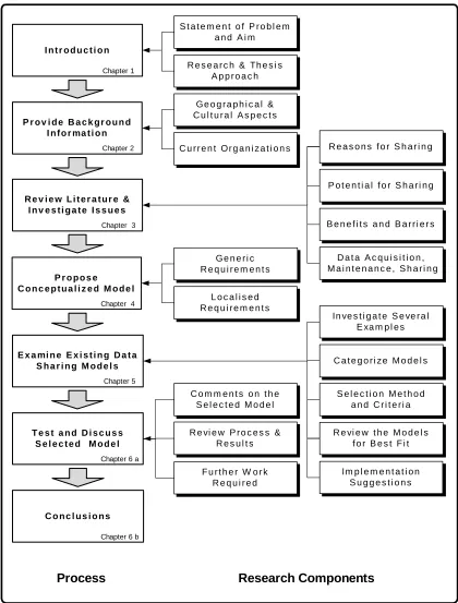
1.6 Research Thesis Structure
To achieve the aim of the research, the thesis is structured using guidelines suggested
by Evans and Gruba (Evans and Gruba 2002) in determining the research approach.
Chapter 2 presents a discussion of geographic and cultural aspects in Saudi Arabia and
a review of GISs which are either implemented or in the planning stage as stand alone
systems in the two Saudi Arabian organizations being used in the research, the Saudi
Telecom Company and the Jeddah Municipality.
A review of relevant issues including potential benefits and possible barriers is
presented in Chapter 3. The research incorporates a review of available literature on the
subject and anecdotal insights from experience in the industry in Saudi Arabia.
The research mechanism, or instrument, is defined in Chapter 4 with an explanation
given of the rationale for using this mechanism compared with alternative
methodology. A conceptual model is presented, and this is followed by a discussion of
its applicability.
Chapter 5 presents various data sharing examples and uses these as case studies.
Through an analysis of their characteristics, the research attempts to determine if these
models may be appropriate for Saudi Arabia, and then suggestions for an
implementation plan are proposed for the most suitable model.
In Chapter 6 the results of the research are discussed drawing on Chapters 2 and 3,
which were background chapters, and on Chapter 5 which was the analysis chapter. The
selected model is reviewed and conclusions drawn in each of the earlier chapters is
discussed. An appraisal of the research methods used in preparing this thesis and the
outcomes achieved is conducted applying SWOT analysis techniques.
As a conclusion in Chapter 7, the discussion points raised are aligned with the aim of
the thesis, as stated in Chapter 1. Acknowledging the limitations of the study
undertaken, further areas of research are then recommended.
Index
7 Research Components
Process
G e o g r a p h i c a l & C u l t u r a l A s p e c t s
C u r r e n t O r g a n i z a t i o n s S t a t e m e n t o f P r o b l e m
a n d A i m
R e s e a r c h & Th e s i s A p p r o a c h
P o t e n t i a l f o r S h a r i n g
B e n e f i t s a n d B a r r i e r s R e a s o n s f o r S h a r i n g
D a t a A c q u i s i t i o n , M a i n t e n a n c e , S h a r i n g I n t r o d u c t i o n
Chapter 1
P r o v i d e B a c k g r o u n d I n f o r ma t i o n
Chapter 2
R e v i e w L i t e r a t u r e & I n v e s t i g a t e I s s u e s
Chapter 3
E x a mi n e E x i s t i n g D a t a S h a r i n g M o d e l s
Chapter 5
G e n e r i c R e q u i r e m e n t s
L o c a l i s e d R e q u i r e m e n t s
Im p l e m e n t a t i o n S u g g e s t i o n s R e vi e w t h e M o d e l s
f o r B e s t F i t C a t e g o r i z e M o d e l s In ve s t i g a t e S e ve r a l
E xa m p l e s
S e l e c t i o n M e t h o d a n d C r i t e r i a
F u r t h e r W o r k R e q u i r e d C o m m e n t s o n t h e
S e l e c t e d M o d e l
R e vi e w P r o c e s s & R e s u l t s P r o p o s e
C o n c e p t u a l i z e d M o d e l
Chapter 4
T e s t a n d D i s c u s s S e l e c t e d M o d e l
Chapter 6 a
C o n c l u s i o n s
[image:22.595.109.529.96.649.2]Chapter 6 b
Index
1.7 Conclusion
This chapter has established geospatial data sharing in Saudi Arabia as a topic that is
worthwhile examining not only because of the potential financial benefits of data
sharing, but also because there may be significant obstacles to its introduction.
The research background section established the relevancy of locating the study in
Saudi Arabia and a statement of the problem pointed to the need for a thorough,
balanced investigation. To establish the direction of the research, the aim of the study
was given followed by the thesis research structure. By having the research approach
presented diagrammatically, readers of this thesis should be able to follow the logic of
the argument.
The introduction leads into Chapter 2 which will provide a background to the
geographical and cultural aspects of the research, and which will also give an
appreciation of the organizations involved, prior to a review of available literature and