EDGE, CENTER, AND SPINE:
EXPLORING THE MULTI-DIMENSIONALITY OF CONTEMPORARY LANDSCAPES IN
MIDDLE EASTERN CITIES
Ashraf M. Salama* and Anna Katharina Grichting**
* Department of Architecture, University of Strathclyde, Glasgow, United Kingdom **Department of Architecture and Urban Planning, Qatar University, Doha, Qatar
[email protected]; [email protected]
Abstract
This paper offers an overview of landscape interventions in three Middle Eastern cities and a positional interpretation of the way in which different landscape typologies can contribute to their socio-spatial and environmental contexts. The paper identifies three levels of contribution of contemporary landscape – edge, center, and spine - corresponding to three landscape typologies: the edge typology is a linear coastal landscape that acts as an interface between the city and the sea; the central typology is a city park that reactivates or regenerates a fragment of the city and communities that surround it; and the spine is an ecological infrastructure – a wadi - that articulates and curates the natural and constructed flow of water creating productive landscapes and public spaces. In undertaking the discussion and analysis, a multi-layered general methodology was employed. First, to induct generalities on three projects identified a literature review and analysis of development and technical review reports is conducted in order to elucidate a considerable number of issues underlying each landscape typology while classifying them under three main sub-headings that include contextual background, evolutionary design and planning aspects, and key spatial design features. Second, to deduct particularities concerning the contribution of each typology, critical discussion, reflection, and reference to some empirical studies are carried out with the intention of unveiling the contribution of each typology to its context and to the city within which it exists.
Keywords: landscape architecture; urban parks; urbanism; Middle Eastern cities
INTRODUCTION
The projects presented here have been selected to represent this new socially integrated and ecological approach to landscape in Middle Eastern cities. While the Al-Azhar Park and Wadi Hanifa projects have been widely published and received awards, recognitions, and a considerable coverage in the international media, the Doha Corniche is as yet, not considered as a “landscape project.” Nevertheless, it has been the subject of several international competitions and numerous speculations, and is probably the most central and symbolic public landscape in the city of Doha.
When we refer to multi-dimension we speak of the expanded scale mentioned before, but also the multiple urban and social dimensions that these landscapes contribute to the city. These dimensions obviously depend on the urban context – geographic location, accessibility, publicness – of the landscapes, but also on the synergies and catalytic effects that these open spaces can create on the surrounding urban fabric and urban dynamics. In the three case studies, we present the landscapes as social and urban infrastructures, belonging to a “green network” that is increasingly becoming an important matrix of any city that aspires to sustainability. Aside from their “beautifying” roles, the social and urban functions of these landscapes are emphasized, including such issues as social equity and accessibility. The objective is not to compare between the three types but rather analyzes different types of contribution of each landscape typology. These include: creating a maritime façade for an emerging city, offering access to the water’s edge, providing social spaces for all the user groups, offering a central park that generates a series of regeneration projects at its edges, providing biological waste water treatment while increasing availability of water for landscape irrigation, amongst others. Our premise is to highlight the interdependent variables of sustainable urban qualities that confer to these landscapes “multi-dimensional” functions.
LANDSCAPE AT THE EDGE OF THE CITY: THE CORNICHE OF DOHA, QATAR
Contextual Background
Located halfway along the western coast of the Gulf, the 11,437 sq. km State of Qatar consists mainly of flat low-lying rocky desert and coastal salt flats or sabkha. The peninsula has a 563 km sandy coastline with numerous small islets, sand dunes and reefs. The types of habitats found in Qatar include sand dunes, hammada (Arabic for 'unfruitful') desert of rocks and gravel, rocky ecosystems, mangroves, sabkha (salt flats), wadis and runnells, and depressions called rowdat that collect fine sand. Qatar benefits from year-round sunshine, with temperatures ranging from 25° (74°) up to 45° (113°) in summer.
During the second half of the 20th century Qatar witnessed its first modern urbanization
period accompanied by rapidly increasing oil production and lucrative oil export contracts. Today new development strategies have been initiated and implemented to diversify its economy; these have led to a second major urban transformation process. Doha, the capital city of Qatar, has seen rapid growth from a small fishing village community in the middle of the 20th century to a
vibrant emerging regional urban center with more than 2.0 million inhabitants (Salama and Wiedmann, 2013).
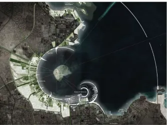
The Corniche of Doha is perfectly engineered and designed landscapes, formed by landfill. In 1972 the waterfront promenade has been progressively shaped by successive landfills - formed following extensive dredging work carried out during the late 1970s and early 1980s, which reshaped Doha's coastline - and carved into a geometrically perfect arc that enables the city to look at itself. It is an urban and landscape design that contributes to a spectacular waterfront scenography, creating a strong visual relationship between the historic core of the city and the emerging new business district at the West Bay (Figure 1).
intensive phase of urbanization, that reacts to the global condition by introducing knowledge economy, cultural institutions, and state of the art building interventions. Between the historic city and the new West Bay towers, the landscape is punctuated with the narratives of the city’s development, with the post-independence institutions buildings – such as the Emiri Diwan, the National Theater, and the General Post Office and other government buildings. The Corniche can be likened to a vast amphitheater that surrounds Doha Bay - like a moving stage that is crisscrossed by the passing Dhows, commercial tankers, cruise ships and pleasure boats. Extending for several kilometers along the Doha Bay, the Corniche is a linear landscape of movement, animated by the joggers, walkers, and cars along its streets and walkways (Figure 2).
[image:3.595.136.468.244.506.2]
Figure 1. Aerial view of the city of Doha and the position of the Corniche (Source: Google Earth)
[image:3.595.137.468.551.685.2]Evolutionary Design and Planning Aspects
The crescent shaped Corniche was constructed under the then new Emir Sheikh Khalifa bin Hamad al Thani who undertook the planification of a capital city for the new independent State of Qatar in 1972. Land reclamation—already practiced in several other Gulf countries—was proposed by Llewellyn-Davis as an alternative to acquiring land from private landowners – and, beginning in 1974, waste from dredging the deep water Doha Bay was used as landfill for the adjacent salt marshes and shallow sea areas. William Periera Associates was hired to develop the concept design for the West Bay area and the Corniche, with the total project area covering 2,000 hectares, which included the waterfront promenade and park overlooking Doha Bay (Nagy, 2000). The mechanism of land reclamation and the creation of Doha Bay was presented as a “beautification” project, turning shallow, unattractive salt flats into a turquoise deep water bay, creating an attractive central and visible location for real estate investment, public institutions and cultural and leisure spaces for the new independent capital.
In 1998 the Doha Corniche Project Competition was launched to solicit designs from seven leading landscape firms worldwide that included Jean Nouvel, Martha Schwartz and Zaha Hadid which were not implemented (Archnet, 2014). In the 2007 Qatar National Master Plan— QNMP, an important component of Doha’s Redevelopment Projects was the Doha Corniche Enhancement Plan. This plan foresaw an upgrading of the Corniche to confirm its role as the symbolic landscape of Doha—as a monumental destination and ceremonial corridor—to serve both Qatar’s residents and the increasing number of expatriate professionals, visitors and tourists. The plan, which included new parks adjacent to the Corniche, was part of a strategy to increase the number of parks and open spaces in response to a rapidly rising population and to develop more tourist attractions, including gathering places for arts, culture and recreation. The project involved the expansion of the pedestrian promenade, doubling it to around 14 km extending beyond the crescent in the north direction toward the historic city and Doha International Airport. It included plans to enhance the existing spaces and create new functional areas, to increase waterfront activities, and make the Corniche more accessible to vehicles and pedestrians in order to attract visitors and activities.
More recently, international architects (amongst them Kann Finch and Symbiosis Architects) were asked to submit projects for the redesign of the 25km Doha Corniche district to provide a pedestrian-based community in an area currently dominated by cars (Figure 3). A scheme proposed by Kann Finch divides the Corniche into five key sites offering different opportunities and design outcomes (Kannfinch, 2013). A new light rail line with adjacent walking canopy is integrated into the entire ring of waterfront land in order to foster pedestrian activities while offering an alternative to cars. One of the major design challenges, the sustainability of green landscaped areas, was achieved by water re-use strategies to the Emir’s office (INNOCENT, 2003). By and large, while the overall plans for improvement of the Corniche lie stagnant, three parks have been designed and built (or are in final construction phases) which are directly connected with the maritime crescent. The Al-Bidaa Park, which runs parallel to the Corniche, is the first to have been realized, followed by the Museum of Islamic Art (MIA) Park, and the Sheraton Park, which is still under construction.
Key Spatial Design Features
Figure 3. New Scheme for Doha Corniche by Kann Finch (Source: http://www.kannfinch.com/projects/corniche)
While projects are now being envisioned to extend the Corniche landscapes and cultural spaces, the discussion here is limited to the 7 kilometer crescent bay waterfront promenade, as well as the adjoining waterfront parks and public spaces. These include the Sheraton park, located at the northern extremity of the Corniche, connecting the waterfront promenade with West Bay and the new convention center, and the Museum of Islamic Arts Park marking the Southern tip of the arc. Both these parks are associated with major landmarks, the distinctive pyramid-shaped Sheraton Hotel, and the singular and insular Museum of Islamic Art, built on the water.
Aside from its perfect and dramatic geometry, the Corniche does not have any salient design features. Albeit, on National Day and other special occasions such as religious and civic holidays, and visits from foreign dignitaries, the roadway is decorated with elaborate lighted arches, decorative lightings, flags and temporary landscaping (Nagy, 2000 and Wiedmann et al, 2012). The Corniche road itself consists of a six-lane roadway lined with palm trees, flowerbeds, and sculptures that symbolize the Arab culture. The roundabouts along the Corniche also function as important landmarks in the cityscape of Doha with public art, usually sculptures, at their center, representing scaled-up or abstracted elements of Qatar’s past heritage (Bedouin Coffee Pot, abstraction of Qatari fabrics), or symbols of Qatar’s new global position (a world globe, a monument depicting Qatar's membership in the Gulf Cooperation Council). The Corniche has few cafes and restaurants, but there is one restaurant on the water more or less at midway along the promenade as well as Karak and snack kiosk that act as people hubs along the promenade. Electrical Bicycles are on hire near the Sheraton.
appear to be insufficient. This hinders people to stay for a long time although there is another incentive for long stay; a WIFI network provided in key areas along the promenade.
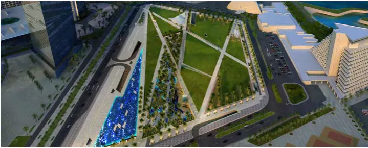
[image:6.595.121.481.283.428.2]The Sheraton Park: The Sheraton Park is the creation of a renewed public green space covering the area from the Doha Bay Corniche to the Sheraton Hotel, just across from the West Bay emerging business district and the Diplomatic Area nearby. The project - currently under construction - includes the design and creation of a public park, a two-story underground car park accommodating around 2,000 vehicles, in addition to a tunnel connection leading to the convention center being constructed adjacent to the Sheraton Park (Figure 4). The proposal also includes a maintenance-depot and a control center for Doha’s future light-rail passenger transit system and two connecting entry-and-exit tunnels. According to the developers, Qatar Diar and DaVinci, The project consists of a 73,000 sq. m. public park of “exceptional quality,” including basins, water fountains, children’s playgrounds, cafes and restaurants (QDVC, 2013).
Figure 4. The New Sheraton Park (under construction) (Source: www.QatariDiar.com)
MIA—Museum of Islamic Arts Park: The Museum of Islamic Arts Park was developed by Qatar Museums Authority (QMA) and is located on the grounds of the acclaimed Museum of Islamic Art, which was designed by I.M. Pei and opened in 2008. The 70-acre public park – also designed by I. M. Pei associates to complement the Museum – is formed by landfill, creating a new arc-shaped pier – a mini-corniche lined with palm trees - and a landscaped peninsula with dune shaped hills covered in grass. The circular promenade provides visitors with a full panoramic view of the Museum, situated on the water adjacent to the Corniche and the hills and terraces of the cafes offer spectacular views of the Doha Bay and skyline. The focal point of the park is a site-specific public artwork entitled “7” by the internationally acclaimed American artist Richard Serra, his first work in the Middle East. The sculpture consists of seven rectangular pieces of weathering steel approximately 24m. tall by 2.44 m. wide by 100mm. thick leaning against each other in an approximately 7-meter diameter heptagonal plan configuration.
programs and art workshops. Forthcoming program elements include an amphitheatre with a floating stage located at the east end of the peninsula and a future formal restaurant at the west end of the peninsula.
LANDSCAPE AT THE CENTER OF THE CITY: THE AL-AZHAR PARK, CAIRO, EGYPT
Contextual Background
Contemporary Cairo encompasses fragments that represent a symbiosis of urban, natural, cultural and economic processes. Much of what manifests itself today as Egyptian politics, knowledge and culture was and is the product of the modern physical, socio-cultural and socio-economic realities of this city. History adds another dimension to Cairo’s architecture and urbanism. It reflects the intersection between place, society, culture and technology. This has made it a complex and diverse city with over 18 million inhabitants and a range of established traditions, where the symbols of religious, political, institutional and economic powers are often competing (Salama, 2002). Accelerated population growth has had a severe impact on the city’s infrastructure and services where the capacity to cope with that growth is really limited. Immigrants from rural areas to the urban metropolis continue to live in squatters’ settlements on the urban peripheries of the city. This in turn has increased the pressure on the public services thereby attracting substantial political attention at the expense of other issues where the need for open green spaces has become an urgent necessity (Salama, 2008).
In 1984, the project’s idea came into existence at the Aga Khan Award for Architecture’s conference titled The Expanding Metropolis: Coping with the urban growth of Cairo. With the clear decline in Cairene housing quality, the development in addition to the conservation of the city became a critical concern. Conceived as an urban park, the aim of the Al-Azhar Park project has been to bring some greenery and open spaces to Cairo, a city with about one footprint of green for every resident (Figure 5). Scarcely found in park settings, the park’s site is the located derelict 30 hectare Derassa neighborhood, abandoned for over 500 years, bordering the 12th century Ayyubid wall, the 15th century Mamluk City of the Dead, and the vibrant historical yet ever decaying Darb Al Ahmar district. For the project to be successful this neglected land would need to be environmentally revitalized and the bordering Darb Al Ahmar district would need to be rehabilitated (Figure 6).
The Al-Azhar Park was inaugurated in Cairo in March 2005. The project is regarded by the local authorities, the developers, and the planning and design team as a catalyst for social, economic and cultural sustainability and is believed to have far reaching consequences for the 200,000 residents of the neighboring Darb al-Ahmar district. It was conceived in the mid-eighties as a metropolitan park that offers much needed greenery and open space to the residents of Cairo. Characterized by distinctive spatial qualities the planning of the park is conceptualized as a series of self contained zones along a central circulation spine and secondary axes (AKTC, 2001). The project was –and still is -- celebrated in the media, and has received a considerable coverage in over 100 publications in different languages including local newspapers, tourist information packages, and specialized international and regional architectural trade magazines.
Evolutionary Design and Planning Aspects
Figure 5. Aerial View of the Al-Azhar Park within the City of Cairo (Source: Aga Khan Award for Architecture)
Figure 6. Masterplan of Al-Azhar Park and the Al Darb Al Ahmar Adjacent District (Source: Aga Khan Award for Architecture)
Directed by the Aga Khan Trust for Culture (AKTC) and coordinated by Sites International, the master planning was complex and methodological, combining foreign and local expertise. The existing topography was assessed and analyzed and the grading analysis was performed with tools based on CAD. The location’s prevalent vehicular and pedestrian patterns increased the need for a main parking area in addition to the pedestrian walkway present in the entire park. This walkway coherently connected all park features and areas while overcoming the innate differences in elevation that have reached 30 to 35 meters of high points above low points.
To achieve the project’s aims, green spaces were increased and maximized to take up to 10,000 persons in any given day. During the early stages of the master planning of the project, nurseries, housing over 2 million plants and trees, were created on site and outside Cairo as a place for the team to collect and distribute the Park’s needed stock of plant variety. The park is furnished with 89 varieties of trees, 51 shrubs, 5 types of grass, 14 climbers, 50 groundcover plants, and 26 varieties of succulents. As an advantage, the diverse seasonal variations of plant life are a natural and automatic result of Egypt being home to a variety of plant species.
The Park’s irrigation system is made up of a central irrigation management system stemming into a combination of a pop-up head system for areas of low slope and a drip feed system for steeply sloped areas. This eases the management and monitoring of the water usage. In cases of emergency if the main water line becomes disconnected from the Nile, the lake at the south of the Park doubles up as an irrigation water reservoir to supply the irrigation system with ample amounts of water.
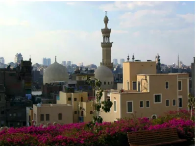
the project, intended to improve the overall condition of the surrounding districts. Cultural monuments and homes were renovated. After surveying the area’s residents, a list of priorities as viewed by the residents was developed. These priorities included but were not limited to training programs, sanitation, housing rehabilitation and renovation, micro-finance, employment, and health care (Figure 7).
Figure 7. Al Darb Al Ahmar District (Source: Salama, 2008)
Key Spatial Design Features
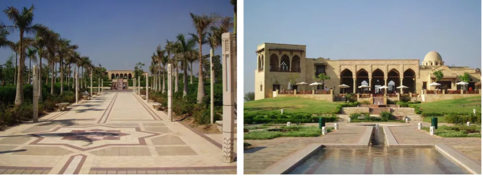
Overall, the park was conceived to include: main spine (palm colonnade); formal garden; hilltop lookout kiosk; hilltop restaurants; children’s structured play area; children’s amphitheater and stage; lookout plaza; water cascade and stream; lake; These elements are missing from most public spaces in Cairo and thus relate the behavioral and experiential aspects underlying spatial quality (Salama, 2002, 2008). The park was strategically planned to provide an exceptional panorama of prominent monuments, such as the Citadel and the Sultan Hassan Complex to the south of the Park (Figure 8). From a hilltop restaurant in the northern section of the Park towards the citadel runs a linear main spine that ends at the southern section of the Park at a manmade lake and a lakeside café, which provides a scene of Um Sultan Shaaban mosque and minaret combined with the Citadel. Stemming from the main spine are numerous smooth and flat areas of lawn and flowering trees and plants, unlike the steep slopes across from the Ayyubid Wall, which are used to stabilize the soil by the treatment of xerophytic plants and ground cover.
occupy up to 150 persons in their interior and external seating areas at once. It offers a notable balance between contemporary style and principles of Islamic gardens. Such principles include the prevalence of symmetrical compositions, the use of waterways and other water features, the commonness of shade areas, and the Mashrabiya. Further south is a community playfield open to nearby residents as well as Park visitors. All the abovementioned Park features are evidence that the Park is conceptualized as a series of areas and sub-areas or enclosed zones along the central passage system.
At the northern section of the site a hilltop restaurant was designed to simulate conventional Mamluk architectural motifs and themes (Figure 9). This restaurant, catering up to 300 persons, includes large indoor and outdoor facilities on different ground levels. These facilities include an external terrace, and internal banquet hall, a gallery space and a manzara (roofed overlook porch). Further north is a small amphitheater with a stage and nearby services was created on the western side facing a major round 12th century tower and serves the park’s musical program.
A very rare and valued feature in Cairo is that the Park is essentially free from cars beyond the parking area. This feature makes the Park more unique and appreciated by its visitors. Inside the Park, in the car free zones, visitors may be transported within the park in a small rubber tire train, while the Park operations team uses electric vehicles (i.e. golf carts). All park areas are lit at night including the major routes and plaza spaces. Direct lighting is rarely used. Yet, tree lighting and lighting of the water elements have been used to provide sufficient lighting, thus allowing the public to visit until midnight.
At the macro level, the Al-Azhar Park’s profile is totally treasured by the larger city. As shown from aerial photos, the uniquely greened Park is seen as a buffer zone separating the Darb Al Ahmar district, the famous historic sites, and the surrounding commercial districts. Through out history, Cairo has actively applied and implemented important civic projects. While environmental rehabilitation has just begun in many major cities worldwide, the Al-Azhar Park project along with the redevelopment of Darb Al Ahmar district is a clear step to continue this tradition.
Figure 8. View of the Pedestrian Promenade
[image:10.595.65.540.482.657.2]showing the Hill Top Restaurant (Source: Salama 2014)
LANDSCAPE AS THE BACKBONE OF THE CITY: WADI HANIFA WETLANDS, RIYADH, SAUDI ARABIA
Contextual Background
Riyadh can be best described as a city of various cities. The old town of Diriyyah and many other old settlements were absorbed by the metropolitan area and diluted within its urban structure. Subsequently, the concept of urban identity took different directions because Riyadh itself expanded beyond the inhabitants’ imagination. Today people visualize Riyadh mainly as North-South spine that connects the old center to the new King Abdullah Financial District along the King Fahad Road (Al Naim, 2013). Other parts transformed to a peripheral extension of the city without real impact on the holistic urban identity of Riyadh.
Riyadh, the capital of Saudi Arabia, was founded on the west bank of Wadi Hanifa, taking advantage of water, stone, and arable lands. Following the rapid expansion of the city that started in the mid-1970s sections of the Wadi (Valley)were turned into wastelands or dumping grounds, while other areas were quarried and mined to provide construction materials for the rapidly expanding city. The subsequent encroachment of constructions and infrastructures, as well as the proliferation of pollution, poor water quality, and water-related diseases were the results of such uncontrolled development.
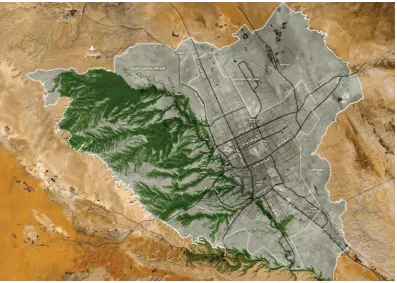
The Wadi Hanifa Wetlands is a restoration and development project of a Wadi that connects the agricultural hinterland to the capital city of Riyadh, creating an ecological landscape infrastructure. With a length of 120km long and a 4500km2 watershed, the valley - located in the
middle of the Najd Plateau of the Kingdom of Saudi Arabia – it is the most significant natural feature in the dry desert region. Once a heavily polluted river, the Wadi was filled with industrial and municipal waste and dead animals and fish, which had an adverse effect on the whole riparian ecosystem along its banks and catchment area. Through an innovative and contemporary processes of naturalization and bio-remediation – led by a team of planners, landscape architects and engineers over a period of almost ten years - the Wadi Hanifa eco-system has been restored and new public spaces and productive landscapes have been created along its banks (Figures 10, 11) (Moriyama & Teshima Planners, nd).
In Riyadh, precipitation averages 60 millimeters per year with short intense rainfalls that cause flash floods and while water is abundant, the population growth from 150,000 in 1960 to an estimated 5 million today has put a strain on water resources. With the construction of Riyadh’s first large sewage treatment facility in 1982, the Wadi – which was traditionally dry except during heavy rains and floods – was supplied with up to 650,000 cubic meters of runoff that are channeled into the river daily, spontaneously creating a new green corridor and a series of small lakes south of Riyadh. These have become a popular destination for recreational activities and a haven for migratory birds, as well as providing irrigation for date palm cultivation along the Wadi’s banks. This runoff water also serves a large oil refinery and is used to irrigate the public gardens and parks of Riyadh.
Evolutionary Design and Planning Aspects
designs for the restoration of the Wadi from the Al-Ilb Dam in the north to Al Hair in the south. The aims of the comprehensive plan involves a number of parameters that include a clean environment, accessibility, environmental quality, public landscape and cultural resources - in order to attract private investment for private-sector projects and private sector tourist investment.
Figure 10.The Greater Riyadh Area and the Location of the Wadi Hanifa Watershed. (Source: Moriyama and Teshima Architects)
Figure 11. Master Plan of Wadi Hanifa Development Project. (Source: Moriyama and Teshima Architects)
[image:12.595.103.503.512.620.2]reclaim their course (Burohappold Engineering, nd). Currently the ADA is looking at further ways of enhancing the main Wadi and to develop and restore many of the sub-Wadis, to bring these into what is becoming more than the ‘Great Park of Riyadh’.
The implementation of the master plan was divided into two parts: The first is the Wadi Hanifa Restoration Project to restore flood performance and water quality, and to complete the restoration of the Wadi bed and the second is Wadi Hanifa Development Program, for the public infrastructure and public landscape capital construction works with associated private sector investment projects (Samhouri, 2010).
[image:13.595.284.535.227.382.2]
Figure 12. Interpretative trails that wind their way throughout the Wadi allowing the public to access the area easily and to direct them to places of interest (Source: Aga Khan Award for Architecture)
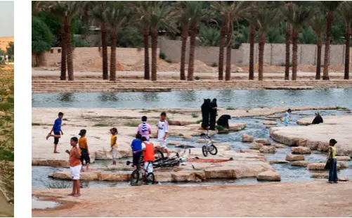
Figure 13. Public Space along the Wadi Hanifa. The parks are designed in a way that provides family compartments, in the form of semi-enclosed areas (Source: Aga Khan Award for Architecture)
Key Spatial Design Features
The Wadi Hanifa region includes large industrialized farms, date palm plantations, two significant archaeological sites, and Bedouin villages along its length and it played a vital role in the establishment of Riyadh as a center for trade and travel in the desert (Moriyama & Teshima Planners, nd).Today, the newly restored Wadi (river valley) acts as a backbone, which articulates a series of linear landscapes and curates the natural and constructed flow of water creating productive landscapes and public spaces. Through a series of operations of remediation and regeneration, the project implements efficient and ecological water recycling while creating new public spaces, reconnecting citizens with the activities and leisure spaces of the life-giving Wadi (Figure 14).
With its very large length and scope, the project integrates multiple scales of design interventions, from master planning to landscape, and from architecture to signage and urban furniture. Described as an “eco-driven strategy” the project combines schemes to enhance natural processes of landscape evolution, highly engineered Bio-remediation facilities and quality-designed public spaces (Samhouri, 2010). The programmatic and functional landscapes of the Wadi features historic areas, wild life reserves, parks, land art, environmental installations, bridges and circulation hubs, natural and man-made lakes, agricultural land, and plant nurseries.
[image:13.595.65.295.228.382.2]Public amenity spaces provide prayer areas and other services and catering outlets, with play and recreation areas for children. An educational and visitors center is planned within the Wadi’s boundary. This center will focus on the educational and social aspect of the Wadi by using videos and interactive features to show how important the Wadi is and has been to the city of Riyadh. 9 major parks were created, with 5 lakes for a total surface area of 25.1 hectares, 7.4 km pedestrian promenades, and 46.8 km of recreational trails created.
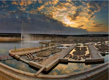
[image:14.595.126.478.282.539.2]In the city of Riyadh, the recreational facilities were combined with habitat enhancement and water quality infrastructure such as natural stone weirs to create a habitat for microorganisms and increase oxygen levels to reduce chloroform bacteria. The large bio-remediation facility is a one of a kind design, which recreates a complex habitat, in turn treating the city and river water naturally. Downstream large Periphyton Benthic Substrate Devices (APBS) have been installed, which have given way to an underwater habitat.
Figure 14. The Wadi Hanifa project successful in providing water treatment while creating a one-of-a-kind natural facility and open-space public attraction
(Source: Aga Khan Award for Architecture)
OVERVIEW OF ACCESSIBILITY, USE, AND ACTIVITIES
The analysis of the key aspects of how each landscape typology aims at achieving specific objectives while being accessible and connected to its larger context, and generating multiple types of use and activities, reveals that the three typologies presented contribute in various degrees to their physical context and their users.
Accessibility and Connectivity
along its entire length leading to other important open spaces of the city and connected to important transport nodes. A metro and light rail system is now being implemented, with a major Light Rail station under the Sheraton Park and others planned along the Corniche. Cycling paths and networks are also planned, which should help to make the Corniche and open spaces more accessible. Therefore, it is expected that Corniche will be better served by public transport in several points along its path. There have also been proposals to bury the Corniche road in order to have a continuity of the open spaces with West Bay and the historic center.
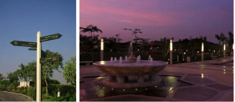
The Al-Azhar Park represents a different case where it appears to be an enclave development since it has fences and nominal entrance fee and therefore not accessible to everyone in the city. Yet, the inclusion of a restoration and development project in the adjacent Darb Al Ahmar district makes it relevant to the immediate socio-spatial context. It is noted that the park is located on major vehicular road, which can be perceived as an interface between the formal planned city and the informal segment of the city. The major and secondary pedestrian spines together with branched off green spaces lead to the main developments within the park including the hilltop restaurant and lakeside café. Referring to an earlier empirical study certain aspects of accessibility and connectivity within the park can be elucidated (Salama, 2008). Responding to the way in which visitors find their way around the park, 30% of 184 respondents to a survey questionnaire stated it is difficult for them to find their way and/or to know their position within, while 10% and 50% mentioned it is very easy or easy respectively. These responses relate to how they value the design of signs and the signage system as 33% valued signage as 'bad' while 36% as 'fair.' Some of the comments stated by those who valued signage and sign design as 'bad' included one or more of the following reasons (Figure 15):
• The only visible sign in lakeside café area was inside the café but there are no maps or
signs near its entrance
• There is a need to have 'you are here' maps
• Size of lettering is small compared to the size of some signs • Because lettering is too small we do not rely on the signs • The problem is at night where signs are not easily seen
• We started to become familiar with the park after our first visit, but first time we came we
were confused
• Signs are not well distributed in the park
• While signs are neatly designed they do not satisfy their purpose
Assessing the lights and lighting system by the users, it is noticed that 'excellent,' 'good,' and 'fair' are equally valued by the respondents where 20% is given to each of these qualities. However, 35% appear not satisfied with lights as a major design aspect and have commented one or more of the following reasons (Figure 16):
• Lights are not good, especially near steps and water channels
• The level of lighting in most cases, especially in lighting posts, is at the eye level which is
disturbing
• The areas behind the lakeside Café and the side of the hilltop Restaurant are not well lit • You can see the source of lights only, not the surroundings
• Lights block vision; you feel they are in the way of viewing the whole location • Some places are scary as they are completely dark
length of the Wadi. The branding’ of the Wadi is achieved through elaborate signage including way-finding and interpretive signage and is enhanced by street lighting and trail lighting systems for the entire Wadi. The way that the vehicular circulation system has been designed and implemented, and the strict codes of conduct in the Wadi, both contribute to the family-friendly atmosphere in the Wadi. In addition, the signage system, with its well thought-out banners, educate and encourage people to act responsibly towards the environment of the Wadi, and contribute to giving them a sense of being actively involved, and an acute sense of ownership.
[image:16.595.65.534.220.424.2]Figure 15. Signage system and sign design: was a major source of users' dissatisfaction (Source: Salama, 2008)
Figure 16. Lights and lighting system: while designed to achieve dramatic visual effects in aesthetic terms, it was a source of users' dissatisfaction in functional terms (Source: Salama, 2008)
Users and Activities
The Corniche attracts a diverse crowd, from the early morning until late evening, strolling, walking and running. In the morning, it is popular for jogging, while late at night; it shows a different cultural view of the city. During the day, workers from the surrounding construction sites in West Bay can be seen sitting in the shade, resting or eating their lunch. The Corniche has also become a meeting place for a new generation of Qataris. Qatari rebels also congregate in the area, with motorcyclists and other non-traditional looking youngsters meeting in the area to meet up or make noise. There are also a number of seasonal and temporary activities, which include open-air exhibitions, Jet Ski Competitions, the National Day Parade and Dhow Parade on December 18th every year.
behind it: in fact, the cafeteria appears to be the major attraction to the space, especially in the evenings when people come for refreshments.
The space is generally crowded with different types of users on weekdays; at weekends they proliferate in the early morning and early evening. However, fewer users were noted on weekday mornings, probably due to the fact that most people are at work. In contrast, maintenance workers and gardeners were strongly represented in the mornings when they are on duty during hours where they are less likely to disturb visitors. It was also noted that a considerable number of male users visited the space specifically to drink traditional tea (karak) while sitting individually or in groups along the seawall, a protective barrier separating the promenade from the sea, chatting and seemingly enjoying the views of the cityscape or the other side of the bay. Interestingly, motorbike riders (a very small interest group in the Doha population) were frequently noted congregating at the drop-off area, near the car park.
[image:17.595.104.499.439.699.2]Many users also passed by the major sidewalk or pavement, which runs parallel to the promenade, the major pedestrian spine that links the whole waterfront space of the Corniche Waterfront Park. The major activities appeared to be walking or stopping to use the rental bikes available in the green space near the cafeteria. Families were observed searching for a pleasant shady spot under a big tree, particularly near the children’s play area, a space which is dotted with small trees on landscaped artificial hills and hummocks. Casual observation at other times, apart from scheduled behavior mapping times, records that the space is more vibrant and more heavily populated during special events such as Qatar National Day celebrations and water sport events and competitions. While overall adults and children seem to enjoy spending their time there, pursuing their recreational interests and activities, the space lacks sufficient outdoor seating and significantly lacks parasols or other forms of shade, which could potentially make it more appealing for use by more groups, especially during the hot and sunny daytime hours.
Figure 20. Generated behavioral maps based on observation periods at the mapped space (Source: Salama et al., 2013)
The Wadi Hanifa along its length is used for multiple productive and recreational activities including agriculture, leisure, tourism and water management. Its functions for water management include a channel system that biologically remediates wastewater as it flows along the channels and the major Bio-remediation Facility that also collects data and monitors the water quality. The seven major public landmark parks (with additional two under construction) along the Wadi are used as important leisure and tourism spaces for the permanent and visiting population of Riyadh. Around 50 kilometers of walking trails running throughout the entire park system serve for sports and wellness, and also as soft mobility and pedestrian links between for the public landscapes, and are also complemented by a series of pedestrian promenades. As the Wadi is becoming visibly green and the water increasingly clean, the people of Riyadh have started using the Wadi parks and open spaces in large numbers as evidenced by the almost full capacity crowds on weekends. The Bio-remediation Facility is doing the work of cleaning the water and it is performing beyond expectations.
ranger patrol service for help and security, and operate in coordination with the city’s fire and police departments. Maintenance and management of the Wadi is underway and will continue to enhance the entire length of the Wadi.
ANALYTICAL REFLECTIONS:
CAN CONTEMPORARY LANDSCAPES CONTRIBUTE TO THE CREATION OF KEY SUSTAINABLE URBAN QUALITIES IN MIDDLE EASTERN CITIES?
Contemporary urban research on sustainability often focuses on environmental concerns by exploring more efficient urban structures as well as technologies to reduce energy waste.
However, in addition to ecological balance the sustainability of urban environments is highly dependent on economic growth and social equity. Holistic sustainability in an urban context can thus only be achieved if social, economic and environmental aspects are understood in relation to each other (Salama, 2007). In this respect, the unique features of each landscape typology have the potential of creating specific sustainable urban qualities. In essence, this reflects the multidimensional aspects of those typologies. While there are positive characteristics that enable each typology to contribute to city sustainability, there are drawbacks that should be highlighted.
In the case of the Corniche of Doha different types of palm tree and grass which overall scenic landscape, line the central spine of the roadway. Sweet water, from desalination, is used for hygienic reasons, as the lawn turf is used by children. A large amount of water is used in the hot months due to evaporation. There are currently two types of irrigation systems and water supply to parks, gardens and open spaces: one is potable (sweet) water supply system from desalination plants used for irrigation of the parks and gardens, the other is treated sewage effluent, which is used mainly in roadside areas and roundabouts, not for public parks and green areas in schools and hospitals. In social terms, the Corniche can be seen as the only public space in the city where people from different socio-economic strata and cultural backgrounds have access to all parts of it. It must be noted, however, that the Corniche in not actually designated as a park or green space in the official maps and documents (MMUP, 2010). Therefore, it is not part of an overall landscape master plan for the city. Thus, surrounding parks are not well networked, and overall, Doha does not have a connected green network of public spaces and parks. Despite the relative success at the social and urban diversity level, physical aspects related to access and connectivity present important challenges to effective and efficient use. These need to be considered as integral components of immediate plans undertaken by MMUP-Ministry of Municipality and Urban Planning. IN addition to inefficient access and connectivity, many of the spaces and gardens lack sufficient outdoor seating and significantly lack parasols or other forms of shade, which could potentially enhance its use and social role within the city.
utilizes an efficient irrigation system, providing water through drippers and sprinklers. The irrigation is regulated by a special weather station, which calculates the water needs based on temperature, humidity and wind speed.
At the socio-cultural sustainability level, a large-scale archaeological conservation task was initiated. This includes the restoration of a 1.5 kilometer stretch of the eastern Ayyubid wall. The neighborhood of Darb al-Ahmar is one of the poorest and most populous areas of Cairo, lacking adequate sanitation and rubbish-collection services, with refuse often piled up in the streets and in courtyards. Faced with low rents, absentee landlords invested little or nothing in their buildings, with predictable results: roofs and walls collapsed, the historic monuments came under greater and greater stress, and expectations for the quality of life declined along with physical decay. Yet community and family life remained strong. Small family businesses, including carpentry, tile making, and other small crafts, continued to provide a portion of the local population with a living (Siravo, 2001).
Extending beyond the environmental and cultural dimensions, the project for socio-economic development of the adjacent neighborhood was conceived with the idea that the removal of the former rubble dump and its metamorphosis into a park would have a catalytic effect on the general improvement of the district. However, to ensure this result, the project’s scope had to encompass the cultural monuments in the neighborhood and the people of this area. This approach took the form of an integrated urban area development plan containing a series of pilot interventions aimed not only at the restoration of landmark buildings, but at wide-based socioeconomic development.
As well, the project addressed training and employment issues where many of the skills-training programs have been implemented in conjunction with restoration and rehabilitation interventions on the Ayyubid Wall or in restoration projects in the district. Specifically, building tradesmen (masons, carpenters, plumbers and electricians) have been given product quality training. Apprenticeships offered to local youth in connection with stone masonry and carpentry, among other trades, are also integral parts of the program. Other apprenticeships with local businesses have been arranged, through a stipend system, in the fields of computers, mobile phone services, automobile electronics, office skills, and furniture making and tourist market goods.
Training has been offered by local master craftsmen and technicians as well as a handful of foreign experts. The project has offered over 120 training positions in activities such as stone carving, masonry work and materials conservation (Bianca, 2001).
Notably, an integrated urban development in Darb al-Ahmar, with duration of four years, was started in January 2004. During this second phase, rehabilitation and restoration of a substantial number of houses is implemented, as is open space improvement. The existing credit program was expanded to stimulate entrepreneurship and increase levels of income for the area. Provision of basic social services including health, education and solid waste disposal were be addressed in collaboration with local institutions active in these sectors and by strengthening their organizational and institutional capacities. The successful employment scheme started during the first phase will be continued and expanded. Other than the socio-economic program for Darb al-Ahmar, the construction of a hotel and urban plaza with a large car park, recently begun at the northern edge of the site, will also give direct economic stimulus to the district (AKTC, 2001).
planning or design outcome is completely perfect and is satisfying everyone, one should assert that a project of this scale, magnitude, and amount of recognition is not expected to have these influential aspects as major sources of dissatisfaction.
The notion of multi-dimensionality is evident in the Wadi Hanifa Wetlands project as it contributes to three types of urban qualities. The question of developing large territories that address environmental needs is emerging to show how, through careful planning, livable environments can be created. The project, which has received one of the Aga Khan Awards in 2010, responds to this question. It proposes a green, safe and healthy environment while providing continuous parkland that connects the wadi to the city of Riyadh—capital of Saudi Arabia. Integrating residential development, farming, recreation, and cultural activities, a man made oasis was created. In essence, the project’s ecological strategy incorporates a wide range of architectural interventions: from master planning to landscaping and from building to signage and urban furniture.
At the environmental level, the government invested over $100 million (US) into an environmental rehabilitation project which the construction of dams to regulate water flow, new limits on land use such as the banning of such commercial activities as quarrying, and the planting of reeds to further purify the treated and untreated sewage. Rather than the using more traditional techniques the design team proposed to improve the water quality in the lower reaches of the Wadi using bioremediation techniques thus increasing the amount of water available to 120,000m3 of water per day for irrigation, agriculture and other non-potable uses, which could potentially increase to 1,000,000m3 per day by 2025. Storm water management was also an important part of the infrastructure, and side water inlets have been reclaimed or added to aid in flood control and habitation.
Integrating the environmental dimension with the socio-cultural one, the project has a very important educational component, which is progressively being enhanced. The rich diversity of flora and fauna found in the vast natural areas of the Wadi is very attractive to school programs and scientific experiments, from elementary level to university level. The Bio-remediation Facility with its large scale, cutting edge technology and informational signage is a very attractive scientific experimentation facility and it is frequently visited by schools. The ADA also has plans for engaging the general public by installing (by 2011) a cable car system that circles the area of the facility with audio presentations explaining the way it is operated and the importance of reusing surplus water (Bodeker, 2001). Looking at the jury citation on Wadi Hanifa, the true merits of the project can be revealed, “The project reverses the tide of rapid urban development, which has seen public space in many cities within the Muslim world fall victim of expropriation and other practices that deprive the population of its resources.” This tells us much about the way in which the project offered an inclusive public space for the inhabitants of the city of Riyadh. In addition to the overarching concern for the environment, the premise of the project, in adopting the notion of providing ecological infrastructure and experiencing the spatial qualities of the environment, is evident in the jury citation “Using landscape as an ecological infrastructure, the project has restored and enhanced natural systems’ capacity to provide multiple services, including cleaning the contaminated water, mediating the natural forces of flood, providing habitats for biodiversity, and creating opportunities for educational and aesthetic experiences.”
growing according to the natural processes that have been allowed to reclaim their grip, in addition to man-made interventions providing open spaces and parklands along the Wadi and extending them into surrounding residential areas (Samhouri, 2010). A combination of public and private investments in cultural, agricultural, tourism, recreational and leisure and mixed-use facilities offers a sound and sustainable economic model.
Despite addressing the three pillars of urban sustainability, the Wadi as a whole is an exclusively governmental project that does not engage the private sector. The fact that the Wadi looks very clean and neat might be seen as a negative aspect where human use cannot be traced, it lacks the necessary support facilities including restaurants, small vendors, kiosks, and the like. The types of functions have the potential of enhancing the Wadi’s contribution to economic sustainability.
CONCLUDING REMARKS
This chapter discussed the multidimensional aspect of contemporary landscape in Middle Eastern Cities. It critically analyzed the notion of how landscape and park projects contribute to the shaping of their immediate context while addressing key sustainable urban qualities. The chapter identified three types of contribution of contemporary landscapes – edge, center, and spine. Yet, The objective was not to compare between the three types but rather analyzes different types of contribution of each landscape typology. Notably, they range from the linear coastal landscape that, to the central park that reactivates or regenerates a fragment of the city and its communities, to the landscape of ecological infrastructure that articulates and curates the natural and constructed flow of water creating productive landscapes and public spaces. Metaphorically, the three types represent different types of interfaces. Doha’s Corniche acts as an interface between the city and the sea, the Al-Azhar Park acts as an interface between the formal and informal segments of the city, while Wadi Hanifa represents a different type of interface between the agricultural plains and the urban center. The three landscape typologies present contemporary projects in different geographies of the Middle East, their analyses reflect the multi-dimensional notion of landscape.
The analysis and classification of the three projects into three topical areas that included contextual background, evolutionary design and planning aspects, and key spatial design features, revealed the premise and thrust of each. While Doha Corniche symbolizes the city as its landmark and is typically perceived as a center despite its geographical location at the edge, Al-Azhar Park and Wadi Hanifa Wetlands projects involve a deeper discourse into the role of landscape in shaping the physical environment and the society within.
REFERENCES
Aga Khan Trust for Culture, The (2001). Historic cities support programme: The Azhar Park project in Cairo and the conservation and revitalization of Darb Al-Ahmar. Geneva, Switzerland: The Aga Khan Trust for Culture. Retrieved from http://www.akdn.org/publications/cairo_brochure.pdf
Al Naim, M. (2013). Urban transformation in the city of Riyadh: A study of plural urban identity. Open House International, 38 (4), 70-79.
Archnet: Islamic Architecture Community (2014). Archnet: Brief for Doha Corniche. Retrieved from http://archnet.org/
Bianca, S. (2001). Introduction: A comprehensive vision of urban rehabilitation. In Aga Khan Trust for Culture, Historic cities support programme: The Azhar Park project in Cairo and the conservation and revitalization of Darb Al-Ahmar (7-14). Geneva, Switzerland: The Aga Khan Trust for Culture. Retrieved from http://www.akdn.org/publications/cairo_brochure.pdf
Bodeker, J. (2001). Architect’s record of Wadi Hanifa wetlands. Aga Khan Award for Architecture. Retrieved from http://archnet.org/sites/4458/publications/531
Burohappold Engineering (n.d.). Wadi Hanifah. Retrieved from http://www.burohappold.com/projects/project/wadi-hanifah-54/
INNOCENT Innovation Center for Design and Technology, Ankara (2003). Design brief for Doha cornice: Qatar’s Centre for Arts & Culture. Retrieved from http://archnet.org/sites/4172/publications/3394
Kannfinch (2013). Corniche. Retrieved from http://www.kannfinch.com/projects/corniche
Ministry of Municipality and Urban Planning – MMUP (2010). Study report: Qatar National Master Plan (QNMP). Doha, Qatar: MMUP, 13.3.
Moriyama & Teshima Planners (n.d.). Wadi Hanifah comprehensive development plan: Case study. Retrieved from http://mtplanners.com/mtpwadi1.html
Nagy, S. (2000). Dressing up downtown: Urban development and government public image in Qatar. City and Society, 12 (1), 125-147.
Pei Partnership Architects (n.d.). Museum of Islamic Art Park. Retrieved from http://www.peipartnership.com/wp-content/uploads/MIAP_panels_web.pdf
Qatar Museum Authority-QMA (2007). Museum of Islamic Art Park concept, facility and business plan: Executive summary. Doha, Qatar: Qatar Museum Authority.
QDVC (2013). http://www.qdvc.com/en/projects.php?action=view&id=16. Accessed May 2013
Salama, A. M. (2002). A critical voice on architecture and urbanism: Contemporary Cairo demystified. ARCHIS: Architecture, City, and Visual Culture, 2002 (1), 29-32.
Salama, A. M. (2007). Sustainability /Trans-disciplinarity: A concern for people and environments between confusing terminology and outdated approaches. INTBAU: International Network for Traditional Building, Architecture, & Urbanism, I (20), Retrieved from http://www.intbau.org/archive/essay20.htm
Salama, A. M. (2008). Media coverage and users’ reactions: Al Azhar Park in the midst of criticism and post occupancy evaluation. Journal of the Faculty of Architecture, Middle East Technical University, 25 (1), 105-125.
Salama, A. M. (2014). Media coverage and users' reactions: Al Azhar Park in Cairo re-examined. In W. Preiser, A. Davis, A. M. Salama, & A. Hardy (Eds.), Architecture Beyond Criticism: Expert Judgment and Performance Evaluation (91-103), Abingdon, UK: Routledge.
Salama, A. M., & Wiedmann, F. (2013). Demystifying Doha: On architecture and urbanism in an emerging city. Surrey, UK: Ashgate Publishing Ltd.
Samhouri, W. (2010). Wadi Hanifa 2010 on site review report. Aga Khan Award for Architecture. Retrieved from http://archnet.org/authorities/1106/publications/1916
Siravo, F. (2001). Reversing the decline of a historical district. In Aga Khan Trust for Culture, Historic cities support programme: The Azhar Park project in Cairo and the conservation and revitalization of Darb Al-Ahmar (35-54). Geneva, Switzerland: The Aga Khan Trust for Culture. Retrieved from
http://www.akdn.org/publications/cairo_brochure.pdf
Wadi (n.d.). In Merriam-Webster.com. Retrieved from http://www.merriam-webster.com/dictionary/wadi
Wiedmann, F., Salama, A. M., & Thierstein, A. (2012). Urban evolution of the city of Doha: An investigation into the impact of economic transformations on urban structures. METU Journal of the Faculty of
Architecture. 29(2), 35-61. 10.4305/METU.JFA.2012.2.2
__________________________________________________
AUTHORS
Ashraf M. Salama
Professor and Head of Architecture, Dr Department of Architecture,
Faculty of Engineering, University of Strathclyde, Glasgow, Scotland, UK [email protected]
Anna Katharina Grichting
Assistant Professor, Dr
Department of Architecture and Urban Planning College of Engineering,
Qatar University Doha, Qatar