P
LOT
-B
ASED
U
RBANISM
:
T
OWARDS
T
IME
-C
ONSCIOUSNESS IN
P
LACE
-M
AKING
A position paper that advocates a different practice of Urban Design based on
SMALL PLOTS, STREET CENTRALITY and DISJOINTED DEVELOPMENT
conducive to a higher level of democracy by means of
broader INFORMAL PARTICIPATION
Prof. Sergio Porta and Dr. Ombretta Romice September 2010
“This quality in buildings and in towns cannot be made, but only generated, indirectly, by the ordinary actions of the people, just as a flower cannot be made, but only generated from the seed.”
T
ABLE OF
C
ONTENTS
1.
I
NTRODUCTION:
ONG
IANTS’
S
HOULDERS...2
2.
U
RBANS
EEDING:
THEC
ASEF
OR AD
IFFERENTD
ISCIPLINE...5
2.1. Sprawl and Towers-in-the-Park: Overcoming the Cultural Problem ... 5
2.2. The Oxymoron in Practice: Planning, Anti-Planning and Different Forms of
Participation ... 7
3.
P
LOT-B
ASEDU
RBANISM...14
3.1. Cases ... 17
Case 1, Middle Age, Firenze, IT: Planning the Urban Expansion, 1250-1350 ... 17
Case 2, Baroque Age, Noto, IT: Planning the New City After the 1693 Earthquake ... 19
Case 3a, Industrial Age, Edinburgh, UK: the First New Town, 1767-1807... 21
Case 3b, Industrial Age, Glasgow, UK: Suburbanization at Hyndland, 1897-1910... 23
Case 4a, Post-Industrial Age, Amsterdam, NL: Regeneration of Java Island, 1991/2000... 26
Case 4b, Post-Industrial Age, Rajkot, IN: the Town Planning Scheme Model... 28
3.2. Learning From Cases: Principles of Adaptable and Democratic Spaces ... 29
3.3. Plot-Based Urbanism in Higher Education: Towards Local Urban Codes ... 31
4.
U
RBANS
USTAINABILITY:
H
EREW
EC
OME...34
1.
I
NTRODUCTION
:
ON
G
IANTS
’
S
HOULDERS
For those interested in Urban Design and planning these are exciting days. A whole
new story is beginning in Scotland where at many levels the promise of a better
world is raising from new forms of synergy between the agenda of Sustainability for
policy makers and that of Place Making for architects and urban scholars in general.
It took a while to reach this point. More than 10 years ago, influential documents like
Towards an Urban Renaissance
(The Urban Task Force, 1999) and
The Urban Design
Compendium
(English Partnership and Housing Corporation, 2000) inaugurated this
new page by summarizing in form of guidelines a wealth of literature from the late
Eighties which included works by Peter Newman and Jeff Kenworthy in Australia
(Newman & Kenworthy, 1999), Peter Calthorpe (Calthorpe & Fulton, 2001) and
Andres Duany (Krieger & Lennerz, 1991) in the USA, Ian Bentley (McGlynn, Smith,
Alcock, Murrain, & Bentley, 1985), Mike Jenks (Jenks & Burgess, 2000) and
Hidebrand Frey (Frey, 1999) in the UK, and many others.
To be true, this new wave of urbanism, which took the names of New Urbanism in
the USA and Place Making in the UK, proceeded on the shoulders of giants like Jane
Jacobs (Jacobs, 1961), Christopher Alexander (Alexander, 1965), Gordon Cullen
(Cullen, 1965), Kevin Lynch (Lynch, 1960), Oscar Newman (Newman O. , 1973),
Donald Appleyard and Allan Jacobs (Appleyard, 1982) (Jacobs & Appleyard, 1987).
These were protagonists of the first sharp criticism to the many facets of conventional
urbanism in the early Sixties, still shrunk between endless
sprawl
and senseless
towers-in-the-park
. Such two models of conventional urbanism stemmed directly from
the theories of those masters of thought, like Ebenezer Howard (Howard, 1902) and
Le Corbusier (Corbusier, 1923), who shaped the new discipline of urban planning
and design at the very dawn of the XX
thcentury.
This paper poses the problem of this scenario in disciplinary terms, it argues about
its premises and outlines its essential features. The scope of this paper is not to
deliver a comprehensive model for a new approach to urban planning and design,
but to set the right framework and rise the right questions so that we can start
thinking of issues such as urban regeneration, informal settlements and massive
urbanization, community participation and representation, beauty and humanity in
space, in a different
way.
[image:4.595.169.502.356.714.2]This doesn’t necessarily means starting from scratch. We should not be obsessed by
the quest for a
new
approach – like too often happened in the past; we should,
instead, restlessly search for a
right
approach. Our reflection leads to concepts like
“Urban Seeding” and “Plot-Based Urbanism” that are inherently based on evidence
coming from what we see on the ground
as a manifestation of evolution through time
:
change embeds levels of permanency as well as of innovation, universality as well as
specificity. Distinguishing between these levels is all-important if change has to be
finally understood and inform our action on the ground.
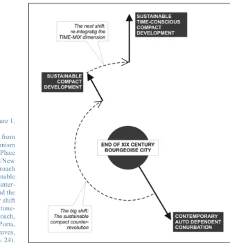
Figure 1.
The ”big shift” from conventional urbanism to the current Place Making/New Urbanism approach (the ‘Sustainable compact counter-revolution’), and the need for a deeper shift towards a more
This paper is the result of passionate discussions among a group of people that
includes, but is not limited to, the authors. Concepts and ideas have been shared and
confronted by email and in person on many occasions and tested with students. In
particular we want to thank Diarmaid Lawlor, who has animated the debate and set
the opportunity to write this paper, as well as John Habraken, Michael Mehaffy,
Kevin Thwaites, Yodan Rofe’, Nikos Salingaros, Robert Adam, Sjoerd Soeters and
Gian Luigi Maffei, who have directly contributed to the formation of these ideas in
many ways.
2.
U
RBAN
S
EEDING
:
THE
C
ASE
F
OR A
D
IFFERENT
D
ISCIPLINE
2.1.
S
PRAWL ANDT
OWERS-
IN-
THE-P
ARK:
O
VERCOMING THEC
ULTURALP
ROBLEMIt is a long story indeed. A story dense of intellectual challenges and adventurous
human trajectories that sometimes resulted in sharp conflicts with each other. It was
also a story of major failures. The whole culture of Place Making that we are here
interpreting for the best future of Scotland can be reduced to a long and difficult
recovery from two models, the Garden City and the Radiant City, and the countless
Levittowns and Pruitt-Igoes
1that derived from them. Those two models have
permeated our urban culture and shaped both our industrial cities and our discipline
since their very origins
. After so much time and so many realizations, after the
environmental challenges posed by global warming and the immense social
challenges posed by global urbanization, the shortcomings of such two models are in
front of our eyes: they are simply not sustainable anymore. We should retrofit
Suburbia
2. We should regenerate Futurama
3. And we should do it now.
1 Levittown is a suburban low-density development realized in 1948 by the developer William Levitt in
New York, USA. The development became the model for many such realizations that Mr Levitt and his Company, Levitt & Sons Inc., realized across the United States after WWII. The model ultimately was popularly taken to epitomize the kind of single-family, residential commercial developments for the lower middle class that we call now “sprawl”. Pruitt-Igoe was an award-winning social housing project designed by architect Minoru Yamasaky and realized in Saint Louis, Missouri, USA, in 1955. The project followed the Le Corbusier principles of the Radian City being constituted by 33 apartment buildings of 11 storeys of height located in a vast “green” open area. In order to create “vertical neighbourhoods” buildings embedded a “service street” at any “anchor floor”, the floor – one every three – where the lift stopped. Eventually the development, notwithstanding the high-rise building typology, did not go beyond a gross territorial density of 50 units per acre. Pruitt-Igoe started since its very completion to be stage for social problems of all sorts, ending up in a complete demolition which took place in 1972. The demolition event, broadcasted live in the whole USA, generated a large debate about the role that the spatial setting plays in shaping social behaviours and a first popular awareness of the shortcomings of the modern city. Pruitt-Igoe is still now taken as a symbol of the failures of modern city planning as applied by celebrated masters of architectural theory and profession.
2 The popular meaning of ”suburbia” refers to a mainly automobile-dependent, low-density low-rise
residential development located at commuting distance from any urban centre. This “sprawled” model of urbanization has been typically constituting the most of urbanization processes in the western world across the XXth century. Recent studies have emphasized changes in the role and structure of Suburbia after the passage to a post-industrial age (Garreau, 1991), or its morphological character as related to that of urban centres (see especially the Urban Morphology Research Group, University of Birmingham, http://www.gees.bham.ac.uk/research/clusters/urbanmorphology/index.shtml).
There are obstacles in front of us. One may think that such obstacles are very hard to
overcome because they are enrooted in complex financial or political problems, but
that is not the case. The problem is mainly
cultural
. And the first thing we can do to
move our civilization forward towards better places is to acknowledge that there has
been a deep cultural problem, it has mattered a lot, it is still here and it is not going
to be removed without effort.
Look around the new “urban jewels”; give a glance to glamorous architectural
journals; listen to what is taught in the best schools of architecture. Generations after
generations, we architects still perpetuate the gospel of conventional urbanism in a
surreal childish game, where the higher the failure, the greater the honour. Our idea
of designing cities is that you should do the job pretty much as if you were designing
a building, but just a bit larger. Urban Design is still based on the scaling out of our
architectural visions. Architects are very young professional figures: in past they
were
master builders
, serving the community by doing the right thing as it had always
been done before, which resulted in adopting, preserving and respecting the overall
structure of spaces. Even when a different professional figure emerged in the
Renaissance and got established in the XVIII
thcentury, that of the architect scientist,
builder and historian who responded to the new needs associated with major
specialist buildings, those prominent constructions were conceived as part of the
broader urban fabric with which maintained and reinforced the spatial links.
Then, architecture was entirely reconfigured, in a different and even opposite way.
We should pay a lot of attention to this passage. This passage, at the beginning of the
XX
thcentury, is crucial, because architecture changed its status from being a
practical
art and an experimental science,
in the age of the master-builders as much as in
Palladio’s age, to being just
a branch of the visual arts
in the age of the avant-guards or,
as Habraken calls it, the age of “Palladio’s children” (Habraken, 2005). It is at this
point that the dimension of the extraordinary prevailed on the ordinary, which has
always been by far the largest portion of our cities, without even the slightest
awareness of that, and architects started doing a different job. But the problem is
that, in John Habraken’s words,
“the demands of the everyday environment are vastly
different from what is required to create the extraordinary. Nevertheless, the profession’s self
image, publications and ways of working still cling to its roots in monumental architecture”
(Habraken, 2005, p. IX).
The attitude to deal with the ordinary environments of our cities as if they where
extraordinary exceptions is the cultural problem of architects-urbanists
. This trap has
substantially contributed during the XX
thcentury to subvert the very fundamental
Box 1.
Notes on step-by-step adaptation as a scientific problem in our cultures.
Here we can see that, as part of the broader cultural problem, there is a major scientific problem that must be addressed. We cannot find better words to define it than Christopher Alexander’s: “In many real world systems, both in purely natural systems, and in those places where people form communities with animals, plants, and other people, the central observable is a close-knit adaptation of the system elements, usually arising over time, and expressed in the intricate geometry of the system.
This close-knit geometric adaptation has not been a major focus of scientific study, because it eludes simple algorithmic formulations. Studies of co-evolution and ecological evolution have moved in this direction, but they rarely concentrate on the geometry of the evolving system. That is not because this adaptation is too complex to be modelled, but rather because the elements of such are so simple, and so rooted in common sense, that they nearly elude the algorithmic and algebraic formulations that we view, wrongly, as more sophisticated.
For example, if a farmer places a row of fence posts, then runs a top rail, braces it here and there where it seems needed, allows it to relate in natural ways to declivities in the ground, or to nearby trees, this is supremely ordinary; it is characterized entirely by common sense, and by the farmer’s ability to pay attention to the situation of each post, each rock, each bit of soil, each slope – and do it right. This oh-so-simple process eludes algorithmic formulation, because algorithmic formulation is not well tailored to this task, and at best only partially helpful in allowing us to grasp what is really going on.
That is not to say that a sensitive fence-building process is trivial or unimportant. On the contrary, the character of this minute, step-by-step adaptation is vitally important in the world, and we have been ignoring it, in recent decades, at our peril. But we do not have a theoretical model that emulates this process. As a result, the ability to perform adaptations in the real world according to such a process has been worn away and destroyed by other processes that are largely bureaucratic – often too bureaucratic – and, in their essence, algorithmic. The planners, building officials, construction companies, and engineers who have redefined everyday processes during the last 100 years, working in a broad context of algorithmic thinking, have, without explicitly intending to, destroyed a far more subtle process. Until that subtle process is acknowledged, and then redefined in modern terms, it will not have the status it requires to play an effective role. The deep adaptation that nourishes the physical world requires this kind of adaptation. We can think of this adaptation process as a highly sophisticated computation, performed on real sticks and stones, producing deep and subtle results (…). All this is hardly more than common sense. Yet the fact remains that this kind of adaptive process does not currently have an acknowledged part in theories of algorithms, in developmental biology, in architecture, or even in system theory. It is not part of the mental models in our current toolkit.” (Alexander, In print).
Rediscovering the essential properties, the permanent structures of places, to be able
again to design the contemporary ordinary city: that is at the heart of the challenge.
This approach is evidence-based and challenges our mother-discipline of architecture
to the heart, questioning its very foundations. Apparently, it is a leap into an entirely
different scientific domain and begins to delineate the foundations of a different
discipline.
2.2.
T
HEO
XYMORON INP
RACTICE:
P
LANNING,
A
NTI-P
LANNING ANDD
IFFERENTF
ORMS OFP
ARTICIPATIONkicking, and without which a city can just be bad, because it is dead:
adaptability
.
Adaptability, or
the structural disposition of spaces to change by welcoming changing needs
in time
: that is key.
But if we bring the idea of self-organization from the domains of nature and society,
where it has been firstly investigated, to the specific field of urbanism, we find one
particular and very profound feature that, if missed, will render our approach too
general and eventually blind:
self-organization in cities has never been alternative to
planning
. Quite on the contrary, self-organization in cities has always been
the effect
of
planning:
“building the city today could mean the wish to find again, perhaps with different
forms, the qualities of proximity, mixture and the unexpected, i.e. a public space accessible to
all, a variety of mixed activities, a built-up area that keeps adapting and transforming itself in
unplanned neighbourhoods.”
(Samuels, Panerai, Castex, & Depaule, 2004, p. 159).
Unplanned neighborhoods are the result of adaptations and transformations of
formerly planned structures. All major historical centres that we love today and that
to our eyes epitomize organic and possibly “spontaneous” growth are in fact the
result of transformation layered in time over structures that had largely been
subdivided according to a plan since their very first origin, transformations that – in
turn – had often been constituted by the addition and overlapping of single planned
developments. It is in fact that
kind
of planning practice, heavily based on the work
of surveyors acting under the commission of land holders (Slater, 1988) (Conzen,
1988), that made it possible for those transformations to occur and keep happening
that reshaped a planned fabric into a rich, diverse and seemingly “natural” built
environment.
This is to say that we should escape the flat juxtaposition of planning and
self-organization that has so heavily breaked our capacity of innovation in even the most
progressive theories of urbanism in last decades. No one has ever built a significant
piece of city in history only by “spontaneously” adding buildings after buildings
without previously parcelling land, setting space for streets and establishing
common rules and rights. Admittedly, it was a very fundamental, basic level of
planning, but nevertheless it was about setting limits and shaping norms which
normally were exactly the
right
limits and norms, and nothing more than that. So the
point, if we are to govern again the realization of human and lively ordinary spaces
in our cities, is not necessarily to explore hypothesis of no-planning or radically
alternative anti-planning systems: the point is to learn
what planning is best fit to set the
right spatial structure for future change and adaptation
. That is even more true in our
times, when we need to achieve by virtue of a conscious and organized effort what
once was shared and even unconscious knowledge, i.e. our
“spontaneous
consciousness”
(Caniggia & Maffei, 2001, p.43).
Box 2.
Notes on some problems that consensus poses in processes of formal participation.
“But Icarus has also a second face which is just proper of the strategies for social inclusion: thinking of being able to manage complexity by governing the decisional processes, through the management of processes that are “negotiative”, “interactive”, “participatory” and, in any case, “consensual”. Because at the end there is always “consensus”: it is consensus that legitimates the hyper-realistic tautology (the decision is the right one just because it was taken consensually).
And the problems that consensus in itself poses are not taken adequately into account: problems of democracy (who establishes the criteria for the legitimation of a decision, though consensual? And what if that night, when the “forum” decided, one was at a theatre? Or on vacation? Or in a hospital? Or just felt too tired to get out? Had not the right to feel too tired?); problems of demagogy (who establishes the threshold beyond which facilitators produce invasive behaviours? When, in short, the referee whistles always “in one direction” affecting the final score?); problems of rightness (who guarantees that the shared decision is also the right one? To state that does not imply to deny to the political-technical-cultural elites the possibility to play a socially useful role of vanguard? Is not exactly for that, to put it shortly, that such elites are paid by the society as a whole? Is it not that, following Lyotard (Lyotard, 1979), consensus “brutalizes the heterogeneity of linguistic games”?).
I would like to have an evolutionistic trust so to consider acceptable the idea that “open” urban decision processes will result in better decisions. In a “Darwinism” of that sort, the free competition of arguments struggling for the same resources (credibility, trust, feasibility…) would come out with the survival of the best decision. Unfortunately I believe firstly that the competition is not free, and secondly that what would survive would just be the strongest argument (in the given situation) which not necessarily brings the system as a whole closer to any improvement”. (Porta, 2006, p. 113)
What we need to emphasize in the context of this paper is one aspect that is very
seldom, if ever, cited: the participative agenda, with all its emphasis on subjects
(social actors) that have interests at stake at the moment of creating or regenerating
the place, is even more focused than conventional approaches on the design phase,
and very rarely takes into account the impacts that designed structures cast on future
change. Urban settings do serve generations after generations of human beings in
centuries; on the other hand, human needs and values change with people, which
means in years and even months. So if the spatial structure is rigid and does not
welcome change, it will not accommodate the needs and values of newcomers and
therefore will shortly end up in a profoundly human, unsustainable and
anti-democratic spatial system, no matter the level of participation that had been
originally insufflated into its creation.
Our argument is to say that we
also
need to
reactivate the circulation of information
between inhabitants and powers through
informal
processes of participation based not as
much on large formal gatherings and
structured processes of inclusion as on the
daily and direct control of inhabitants over the
ordinary modification of their own individual
and collective space, at different scales. And
for the reasons discussed above, these very
traditional processes of
informal participation
through ordinary change
need to be enabled
under conditions (including
spatial
conditions)
that must be carefully identified, organized
and planned. If such informal processes are
not equally embedded in a renovated
planning system, the link between planning
and the space of the ordinary is destined to fail
and so the actual content of democracy in
planning to be significantly lowered.
What is the nature of informal participation
then? Jamel Akbar (Akbar, 1988) helps us in
defining this essential problem by focusing on
the many forms of
control
, i.e. who is
legitimate to change what in the built
environment of the everyday.
Box 3.
“Form of submission” and “party’s size”: elements of informal participation in spatial
change after Jamel Akbar.
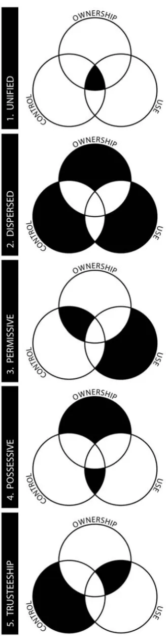
In describing the differences between the traditional and the modern Muslim city, Jamel Akbar (1988) analyses what party uses, controls and owns a space. A “party” is defined as the entity – individual, collective or organizational – that takes decisions.
So every space in a city is definable in terms of the relationships of the parties who own, control and use it. Such relationships, or “forms of submission”, are five, as exemplified in the Venn diagrams reported here in fig. 2.
[image:11.595.336.500.122.754.2]Now, what turns out is that the form of submission deeply affects crucial dynamics in the formation, maintenance and change of the built environment. For example, when a space is owned, controlled and used by one single party
like in the case of a family living in its owned house (“unified” form of submission), maintenance is generally very good, change is gradual and piecemeal and corresponds with the user needs, and the overall environment is socially responsive at the most basic level of society; that was the form of submission that prevailed in the ordinary urban fabric of traditional Muslim cities, but the same applies as a very universal pattern to all traditional cities.
At the other extreme, see how a social housing project is owned by a party (the State or the City Council), controlled by another (the Housing Authority) and used by a third (the inhabitants). In this case (“dispersed” form of submission) the environment is very likely to downgrade in terms of maintenance, as inhabitants cannot do repairs or changes without permission and after all they do not have any interest in doing that.
In addition to the form of submission, the other important factor is that parties are different in size: a property may be used, controlled or owned by one person or many thousands or even millions, or by an organization such as a company or the State, each still constituting one single party. Distance between parties increases with their size and difficulties in managing change increases accordingly: for example one house which is owned and controlled by a single landlord but used by a tenant or one that is owned and controlled by a company and used by a tenant are both in the “permissive” form of submission, but the former case has less “distance” because of the lower size of one of the parties involved (the single landlord as opposed to the company). In conclusion, the overall rigidity of the system is heavily a function of the size of involved parties and their mutual form of submission.
Jamel Akbar’s model, that builds on lessons from John Habraken (Habraken, 2000),
powerfully enlightens the deep nature of processes of change in the space of the
ordinary and tells a lot about how we can encourage informal participation in them
by orienting the planning process towards one or the other of the various “forms of
submission” and by managing the size of “parties” involved, which in turn is
relevant in understanding what we should borrow from traditional cities in a
contemporary version of Plot-Based Urbanism. It is important to understand in fact
that the space of self-organization so typically supported by pre-modern urban
fabrics will never come back on its own under present day’s conditions, which in fact
typically inhibit it or, in other words, “kill it in the cradle”. If we want
self-organization to start up and take on in cities, we must plan them in a specific manner
with that objective in mind.
And here we see the programme of the different discipline: we must
explore the
spatial, social, financial and political structures that will enable and feed once again processes
of self-organization and informal participation in contemporary cities
.
future generations of inhabitants and users. Conversely, if the right principles are
forgotten and left behind, even the most radically community-oriented and inclusive
processes of design may end up in schemes informed by the highest rigidity which
therefore are inherently non-democratic, in that they do not allow future generations
to control and change their spaces (and indeed we have plenty of examples of that).
So what is really important for the different discipline is, much more than devising
and implementing the right process, devising
the right principles
and understanding
how these can inform a variegated set of processes.
Box 4.
Notes on Christopher Alexander’s “A new Theory of Urban Design”.
The idea in “A new theory of Urban Design” (Alexander, Neis, Anninou, & King, 1988) is that city planning as a process should be entirely subverted and substituted by another process which would deal with the same problems in an entirely different way. This in itself is not an evolutionary, but rather a revolutionary idea. Moreover, it relies on the assumption that the problem of creating complexity can be sorted by means of setting the right process (weather it is the right participative design or the right set of linguistic norms/patterns).
However, we often forget that marvellous cities have been growing throughout processes of planning that did not primarily involve formal participation by inhabitants or ‘stakeholders’ in general, nor particularly complex processes of any sort. From the foundation of colonies in ancient Greek cities to that of military camps in the classic Roman age, from territory subdivision for agricultural purposes and successive densification at prominent intersections in pre-medieval agglomerates to the expansions of medieval towns through the formation of “fringe belts” in successive steps leapfrogging “fixation lines” such as city walls (Conzen, 1960), from the new construction of ‘ideal’ cities to the expansion of pre-existent cities in the Renaissance to the Baroque regeneration of entire quarters, ending up with the explosion of the industrial city in the XIXth Century, unbelievably diverse, adaptable and lively urban spaces have been generated out of very top-down planning processes that were actually based on something like the design of a ‘final’ state. In all these cases, there was an authority in charge setting the rules and defining the basic principles, including the spatial rules and principles.
Those authorities, either they were medieval guilds or free municipalities, the Pope, or the Prefect of Seine under the Emperor of France, did not define an open process: they designed streets and plots, they decided what spaces had to be saved for specialist buildings of public interest or for parks, and they arranged how public infrastructure such as water and sewage would be accommodated into the whole picture. Was that, in itself, an authoritative, non-democratic mechanism? No, it wasn’t. It was profoundly non democratic when the model of power was profoundly non democratic, and it was democratic when the model of power was democratic. The extent to which a planning process is democratic or not is not a matter of the planning process itself, it is in fact a matter of the political context within which the planning process takes place: if the authority which delivers the process is democratically constituted, then the planning process is democratic by definition.
Once the fundamental relevance of this informal process is definitely acknowledged,
we cannot but re-tune the scope of our work as city planners and designers. Our
mission should neither be to
create
identity, or beauty, or to determine (social,
economic) success ‘by design’, nor to shape the process that by itself will “inject”
beauty or democracy in our plans, being them finalized to a fixed state like in
conventional or participative plans or to a continuously operating set of norms like in
more suggestive “generative” approaches.
Our mission as Urban Designers is, in fact, to
ensure the minimal spatial conditions (‘right principles’) for informal adaptation to start,
expand and continue in time
. Understanding which are those conditions, and which
form they may conveniently take in practice under local financial and legal burdens,
should be clearly set as our professional duty as scientists, scholars and practitioners.
Driven by this mission, and within this new framework, what we should do in
practice is clear and, to some extent, relatively easily to approach, as it no longer
implies penetrating into an unknown societal, political and disciplinary territory. We
should look back to our planning tradition with a new question in mind:
what is the
technical content of those plans that have demonstrated the capacity to accommodate,
enhance, and maintain in time a sufficient level of informal participation?
and in particular,
what was designed and what was left undefined? And finally: what can we learn
from them that can be successfully applied under present conditions for the
regeneration of today’s cities? In other words, we should de-emphasize the
importance of a planning intervention as a specific act of creation, and stress it being
the
starting point
of a local history whose success is greater where the change is not
dictated by the plan itself but achieved through time. The different discipline starts
with
a focus on all processes of post-design
, in explicit contrast to the contemporary
obsession with the design phase that permeates architecture and Urban Design alike.
We do not know what this different discipline, which we provisionally name “Urban
Seeding”, is going to be in detail. If its construction is going to happen, it will not
happen as a genial revelation from one person or group but as a gradual collective
construction led by an increasing level of consciousness. We know, however, several
of its key aspects that we are searching for. Whatever this new discipline will be, it
will have to do with:
•
Evidence-based solutions,
as opposed to design-based solutions.
•
An emphasis on the
dimension of the ordinary
and
a
science of the common sense,
as opposed to the dimension of the extraordinary and a rhetoric of the
stunning.
•
A major interest in post-design, i.e. in
spatial change and evolution,
as opposed
to a notion of the intangibility of the work-of-art.
•
A priority interest in processes of
informal participation,
as complementary to
formal processes of collaborative planning.
•
A
structural approach
that emphasises what is recurrent in space and time
(within certain spatial and temporal domains), as opposed to the analytical
approach that privileges what is different in space and time.
3.
P
LOT
-B
ASED
U
RBANISM
Plot-Based Urbanism is the set of spatial principles conducive to urban spaces that
are adaptable over time and therefore fit the agenda of Urban Seeding. These
principles are spatial in nature, which means that they are not necessarily related
with any particular kind of planning
process
: on the contrary, every process that
embeds these principles is conducive to adaptable spaces.
Plot-Based Urbanism owes its denomination to the acknowledgment of the
fundamental importance of the plot in the spatial structure of ordinary urban fabrics.
How the plot is shaped, its size and geometry, its relationship with the street and the
street hierarchy, how it forms up street fronts and eventually urban blocks, how all
this informs human activities and urban functions, and finally how the plot finds a
correspondence with property, usage and control, all that is fundamentally the
matter of Plot-Based Urbanism. However, Plot-Based Urbanism doesn’t mean that
everything that is made of plots is fine. Plot-Based Urbanism is a specific kind of
spatial structure made of a
certain
kind of plots, juxtaposed and mixed in a
certain
way, establishing a
certain
kind of relationship with the streets they front, etc.
Eventually, issues of density and compactness are inherently part of the question.
Ultimately,
Plot-Based Urbanism is place making made time-conscious.
Box 5.
Components of Plot-Based Urbanism:
PLOT, STREET, CENTRALITY, STREET FRONT, BLOCK.
A few key concepts ought to be introduced at this point: PLOT, STREET, CENTRALITY, STREET FRONT
and BLOCK as well as their changed fortune in history as elements constituting the fabric of our places. These definitions and reflections come from studies in urban morphology, and by empirical research conducted by UDSU and colleagues over the past years.
PLOT. A PLOT is a fenced portion of land that is entirely accessible from the public space. Though PLOT and property may coincide, and very often do, what defines a PLOT is accessibility, not property. A result of this definition is that large properties may be split into small PLOTS without
necessarily subdividing the property of the land. In all such cases, PLOTS are to be interpreted as the ultimate units of development.
STREET. A STREET is a mostly open space that is publicly accessed and establishes a functional, visual and spatial link with private domains, i.e. PLOTS, by which it is defined. Cities exist and
evolve across centuries, through endless changes of different magnitude happening at different pace. STREETS tend to be the most permanent elements of all, imposing conditions to the fabric that
sits on them. STREETS are highly loaded with character and changing in type, meaning and value whilst penetrating the city. When allowed, they establish a functional and formal relationship with such fabric in terms of fundamental factors like density, land-use, size and geometry and accessibility of PLOTS. Such relationships are mainly the product of the evolution of the fabric in time, being selected according to local conditions including environmental, cultural, technical and financial. The key-factor that constitutes the link between STREET and PLOTS is CENTRALITY.
CENTRALITY. CENTRALITY is here intended as a particular character attached to streets by their geometry (i.e. length) and topology (i.e. the way they are connected to each other). Work conducted in UDSU (Porta, Crucitti, & Latora, 2006) (Porta, Latora, Wang, & Scellato, 2009) as well as elsewhere (Hillier & Hanson, 1984) (Hillier, 1996) has led to mapping and modelling street
CENTRALITY in a reliable and scientifically grounded way. Subsequent work is studying the formal
relation to change in the former. Studies in this line of research are beginning raising evidence on these key-relationship and, though there is a long way to go before these factors are sufficiently understood in detail, research is nonetheless firmly settled in its discipline, i.e. urban morphology, and therefore likely to develop relatively quickly.
STREET FRONT. STREET FRONTS are the formation of PLOTS facing on a STREET. They are the key
components of urban BLOCKS, yet their relation to STREETS is, in history, more direct and important. If a STREET FRONT can adapt to a STREET’s character over time it makes it more versatile;
if on the other hand it is linked to a whole BLOCK, its capacity to change and adapt is restricted, its lifespan shortened, with implications on character and quality of life. STREET FRONTS are made of
PLOTS; and yet again, PLOTS have followed in time markets and density adapting in size to the nature of the STREET,which eventually is heavily influenced by its CENTRALITY.
BLOCK. An urban BLOCK is a mainly built-up urban area defined on its borders by STREETS,whose components are STREET FRONTS. We intend the urban BLOCK as a complex rather than a uniform
element. Its character may vary a lot on each STREET FRONT depending on the type of STREETS it faces upon. An ordinary urban BLOCK exhibits four STREET FRONTS, because it normally sits on four
STREETS. Because STREETS generally possess different “importance” (main, local, secondary...) depending on their CENTRALITY, the STREET FRONTS constituting an urban BLOCK reflect such diversity. This is due, again, by the evolutionary character of the ordinary urban fabric: its formation is led by STREETS developing in time from the most to the less central, a process which is
accompanied by the subdivision of adjacent land in PLOTS and therefore the constructions of STREET FRONTS. Urban BLOCKS are the result of this stepped process, not its constituent unit: they are formed by the completion of this cycle of formation when it reaches the point where four
STREETS close up in a loop and their STREET FRONTS get consequently developed. Planning strategies, especially those related with coding, should acknowledge this peculiar process by assuming that the unit of analysis
and coding is the STREET FRONT,
rather than the BLOCK.
This is indeed nothing new. The “spontaneous” growth of cities has always proceeded by parcelling and then building up the two fronts of STREETS, starting from the
most central ones, where the city originated, and then generating and filling up the less central in time (see below Ch. 3.2: “400-MTS RULE”).
According to Caniggia and Maffei: “However, it is wise to note especially the essential consequence of tracing “connecting routes”: the final achievement of the block concept as the most eye catching and widely used module of the urban aggregate. In a certain sense, it is also the most questionable, because it will soon be clear from the genesis reconstructed through route typology that blocks are progressively determined by the coordination of several pertinent strips of each route and that each pertinent strip is definitely more cohesive and consistent with the reciprocal one, inherent to the route itself, than those re-emerged in the block. This arises because of the contemporaneousness of buildings along opposite sides of the same route and due to these sides being constantly subject to progressive, similar changes during the course of their history” (Caniggia and Maffei, 2001, p.133).
[image:16.595.270.490.376.675.2]This point, which might seem somehow not essential, is in fact one of the most profound features of traditional urbanism. If taken seriously, it makes the difference between contemporary pseudo-traditionalism, a widely practiced character even in the most fashionable place-making realizations of our days, and a different plot-based discipline: “Nevertheless the fact of having brought the block to the foreground has had some perverse effects. It has brought the careless reader or the hurried designer to transform the issue into a caricature: city=block or modernity=single building. The new neighbourhoods of the new towns or modest urban renovation were thus filled with pseudo-blocks, which are but the urbanistic rendering of a valueless postmodern formalism. This has brought us to develop the initial conclusion insisting on the importance of the subdivision of plots and of the status of spaces and of developing a reflective attitude towards the projects” (Samuels, Panerai, Castex, & Depaule, 2004, p.X). Interesting enough, the same happened in the early years of the planning profession too, in an age when still the traditional formation of cities was “unconsciously” part of the planners’ mindset. We bring here (fig. 3) the example of development in Amsterdam after the second version of the Zuid Plan elaborated by Hans Peter Berlage in 1917. In this case the municipality commissioned to the same architect both fronts of one street, rather than the four fronts of one block. The result is the emergence of an overall consistency of building materials and language still in presence of a great variety of specific solutions where the same block was ultimately designed by different architects.
Research on 20 small Scottish towns has shown the evolution of urban blocks
through transitions from traditional to modern and from modern to post-modern
(Hart, Hooi, Romice, & Porta, 2010). In the first transition, for many well documented
reasons (the car being the most consequential), blocks expanded in size, decreased in
functional complexity, lost front definition and became fairly homogeneous in
structure, a pattern that is certainly not limited to Scotland but in fact is very general
across at least the western world (Samuels, Panerai, Castex, & Depaule, 2004). The
consequences of this change have been immense: block size impacted on access and
movement, uniformity of functions and zoning, while lack of front definition largely
affected the character of places. Moreover, the overall
drop in density
had been of
sufficient magnitude to change forever the destiny of our cities. These structural
changes had severe social repercussions: the separation of users and uses as well as
the death of the street as a place for public life. In the second transition (modern to
post-modern which has then led to the now widely practice of “place-making”), a lot
changed to address the consequences of this block expansion on the form and
performance of the city; nevertheless the size of blocks themselves remains fairly
unchanged. The street is correctly perceived as the generator of life, and street
layouts are amended, designed and implemented to encourage activity to take place.
Architecture is scaled down to the people but, crucially,
the block is still perceived as the
design unit
of the urban realm, like for example in the IBA experience in Berlin 1987
(Kleihues, 1987).
At the heart of Plot-Based Urbanism is the understanding that streets and street
fronts require diversity and adaptability to support urban life; in design terms this
implies, very simply,
smaller units
. The modernist/place-making block is still unitary
in its overall conception and execution because it is conceived as the unit. The
traditional city block was smaller and made of aggregations of smaller units, the
plots. Plots have a direct relation to the street, with a profound impact on diversity
and character, but also to the number of entrances to the block, with impact on
activity within the block. Moreover, plots are independent, with impact on the
diversity of the block, and guarantee that such diversity reflects the streets on which
the block sits, impacting on its responsiveness to city life.
3.1.
C
ASESCase 1,
Middle Age,
Firenze, IT: Planning the Urban Expansion, 1250-1350
Author: Gian Luigi Maffei
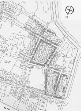
Between 1250 and 1350 the significant growth in population before the Great Plague (1348) brought the number of residents in Florence to about 100,000 people. The urban developments that sheltered this additional population were built in two successive phases, first at Oltrarno in 1259 and then in general in 1280/1333; these were then surrounded by a new urban wall erected outside the earlier one (constructed in 1173/1175).
[image:18.595.224.493.381.743.2]These areas were owned by Conventual Orders, Hospitals and Arts and Crafts Guilds, which therefore became the promoters of allotments which constituted the new urban developments. Allotments, like the San Frediano estate which is reported below in fig. 4, were usually designed along existing streets and property lines: the “matrix routes” were pre-existent routes which were built up in the first pace, then orthogonal streets were built and finally the urban block was closed by a fourth path. The link between path and plot is still clearly legible looking at the “pertinent fringe areas” of each front.
Figure 4. The San Frediano estate, located southwest of the Arno River. The estate was planned as an urban development between mid XIIIth and mid XIVth
Patterns of a different kind were always due to cadastral constraints.
Case 2,
Baroque Age,
Noto, IT: Planning the New City After the 1693 Earthquake
Author: Peter Russell
In 1693 the Sicilian town of Noto was destroyed by “an earthquake so horrible and ghastly that the soil undulated like the waves of a stormy sea, and the mountains danced as if drunk, and the city collapsed in one miserable moment killing more than a thousand people.”(Torbiner, 1982). The destroyed town was abandoned, left to become a city of ruins, Noto Antica (old Noto). The new town of Noto was settled 7 kilometres away on the summit of the Meti, a small mountain near the coast. From 1693 to 1702 the success of the move from the site of Noto Antica to that of Noto Nuova (new Noto) was not certain.
In an effort to ensure the settlement of the new city on the Meti summit, the nobility deeded land to “anyone who needed it” (idem, 1982 p.46). Where a vacant building plot existed in the city the nobility would give the land to a suitable settler, who would lose ownership of the plot if they failed to build and develop the plot. Building plots were given to the clergy and aristocracy, those who could afford to invest in building. The selection of the building site for Noto served their interests and desires for the opportunity to build a new provincial centre in the XVIIth and XVIIIth century aesthetic, as much as any practical function. In the mid XVIIIth century Noto was recovering slowly, with a population half that of the pre-earthquake Noto Antica.
The city developed both on the summit and the slope of the Meti, and had two resulting non-aligned street grids. The building plots also developed in a duplicitous manner, with buildings fronting main roads and the sloping grid having a very regular pattern following the street, and buildings on the interior of the block and at the city periphery having a seemingly random pattern. The heavily coordinated and patterned portions of the city were deeded to and developed by the aristocracy and the clergy, producing an urban landscape in the aesthetic they desired when they elected to relocate the city. The wide streets and defined piazzas were lost entirely at the city’s perimeter, where the peasant class developed the land in a more ad hoc manner responding to the topography and ultimately developing a more medieval pattern. The city divided, presents itself as both a Baroque city in its centre and a medieval city at the fringe.
Building plots of Noto are carefully measured around the central part of the city, and in both the grid of the summit and that of the slope. Plots and block interiors of the urban periphery are more random and organic, emerging more gradually, necessitating winding, narrow alleys. Exterior plots developed first, subsidised by the aristocracy and clergy, interior plots developed slowly, as a requirement of increasing population. Blocks that were laid out for dwellings were planned and built as perimeter blocks with gardens and a small lane traversing the block. A growing population led to these gardens being developed into residential units, and smaller dwellings, blocking the through lane forming an interior courtyard, and a network of smaller lanes.
This pattern of development results in Noto exhibiting a fractured urban form. The two misaligned grids of the city are composed of perimeter blocks, which in all but the most sacred locations were long ago subdivided into smaller plots and infilled with smaller buildings. Outer parts of the city exhibit an even higher level of density resulting in smaller plots, which completely cover blocks that all but disregard the grid pattern, traversed several times by narrow alleys and lanes in the style of Noto Antica.
Case 3a,
Industrial Age,
Edinburgh, UK: the First New Town, 1767-1807
Authors: David Howell, Gillian Black
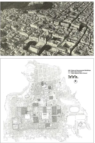
Edinburgh's Town Council, in the mid-1700s, demonstrated a grand, civic example of historical plot-based development which many lessons can still be learned from today. In acquiring land to the north of the existing town core, a substantially-scaled expansion was initiated with the separating valley (contained the Nor Loch) drained and bridged, a process that took over a decade, before the decision was made to prepare a plan for the development of the “New Town”. The intention was that this expansion should be an aristocratic classically-designed residential area to house the town's upper classes whilst the grand streets were also to contain smaller spaces for the serving classes.
A competition was set in 1766 to produce a plan for the laying out of this prestigious new development, which was subsequently won by the 21 year-old James Craig, who created a classically inspired plan to support social hierarchy and civic grandeur through its combination of grand streets, mews lanes and axial linking of squares, churches and views (see fig. 6). Craig developed the detailed feu plan along with a sewer plan which provided comfort to potential purchasers of plots that the land would be serviced properly.
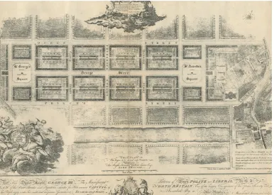
[image:22.595.110.497.427.702.2]The rectangular, gridiron plan centred on George Street, which ran along the topographical ridge, with the two main squares (and associated civic building plots) at either end and was bound by Queen Street to the north and Princes Street to the south. The feu plan (see fig. 7) divided the eight main “perimeter and mews” blocks into plots with dimensions reflecting their position in the street (and associated social) hierarchy - the detail of the building footprints and private gardens were clearly detailed alongside letters denoting feu values. The values against the plots were driven by their street hierarchy position, the building height limit (4 storey on main streets
and 2 storey in mews lanes) as well as their views - whether south towards the rocky outcrop of the mediaeval town core, or north towards the uninterrupted views towards Fife (fig. 8 shows the contrast in plot and street arrangement between old and new towns).
The strong design was of course achievable due to the land ownership control of the Town Council whilst the ability to fund the substantial infrastructure works was due to a period of wealthy prosperity based on Edinburgh's financial industry. This civic strength allowed for such an ambitious plan and the wealth of the individuals purchasing
plots in the New Town and their feu duty payments to the Town also supported this growth. The development of the plots themselves (over a period of forty years from 1767) was undertaken by a range of builders and wealthy individuals who utilised their architects to meet the standards and design required of the feu plan - a plan which was amended over time to allow for a wider range of plots to accommodate professionals and institutions as well as the aristocracy.
The streets were feued in phases to ensure completion of blocks and in the Robert Adam-designed Charlotte Square, a payment incentive was made to the first “feuar” to roof their house first, thus ensuring swift plot completions. Over time, the plots accommodated a greater extent of commercial uses and
the in-built
[image:23.595.239.494.108.310.2]adaptability of the New Town design and its ability to sustain change has been demonstrated by its two hundred year successful transition from upper-class residential suburb to mixed-use civic core.
Figure 7. Exerpt from James Craig’s feu plan, 1767.
[image:23.595.105.380.457.641.2]Case 3b,
Industrial Age,
Glasgow, UK: Suburbanization at Hyndland, 1897-1910
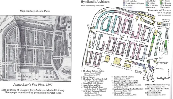
Authors: Wolfgang Sonne, David Howell, Gillian Black
The case of Glasgow, "the tenement city" par excellence (Reed, 1993) (Cockburn, 1925), can be used to highlight the fact that the perimeter block, subdivided into house units, was firmly rooted in enlightened Urban Design of the XIXth Century. Glasgow's first new town plan from 1782 by James Barry showed a pattern of large residential perimeter blocks around George Square, which was then repeated within the Blythswood new town (Arneil-Walker, 1993). During the XIXth Century, the pattern of rectangular tenement blocks, usually four storeys high and containing shops on the ground floor towards major streets, was used for both middle-class and workers' dwellings (Worsdall, 1979). As legislation did not allow for internal wings, all of these blocks were characterised by large internal courtyards which in most cases had been planted. In the working class neighbourhoods, these blocks were designed as units enclosed on all sides, the most uniform areas being Hutchesontown, Govanhill and Dennistoun, all developed during the 1870s and 1880s. In the middle-class neighbourhoods, the block was often subdivided by a lane, thus combining the socially higher model of the terrace with the lower model of the tenement block. Exemplary areas include Woodlands and Hyndland, with the latter being built according to James Barr's plan between 1897 and 1910 as a wealthy Edwardian tenement quarter with most of the buildings by John Campbell McKellar, including a central green square, tree lined streets and green courts (Laird, 1997). Even if all these blocks had been planned as area developments, each block had been structured by town house units, each having its own entrance. Theoretically, each block could thus be subdivided into plots and sold off to different owners. However, originally these structures had been let, and if in the later XXth century the built structure had been sold, then usually it had not been sold as house units, but as single flats. Thus in Glasgow the tenement block with a large courtyard followed a long-lasting tradition and helped to create a city with dwelling quarters which were both extremely urban and pleasant, allowing for a variety of dwellers and uses and nevertheless creating a unique urban harmony.
*** ***
The Hyndland Estate in Glasgow's West End was developed by several builders and a variety of architects, largely between 1897 and 1910. The land was situated on the western periphery of the city, adjacent the estates of Dowanhill, Kelvinside and Partickhill, which had been subject of speculative development, mainly in the form of grand terraces and villas to house the growing middle classes on the back of Glasgow's industrial growth (fig. 9). The Hyndland land had been acquired in 1876 but development was delayed by an economic recession and it was not until the mid 1890's that plans were revisited, supported by public transit improvements in the form of horse-drawn trams (developing into electric trams by 1907) and a passenger rail service to the area (introduced via a new spur from the main line in 1886 when very few buildings existed in the area). The landowner instigated a feu plan for the area, completed by James Barr in 1897 (fig. 10), which was based on prevailing market conditions to provide middle-class apartments as a more affordable alternative to the terraces of Great Western Road to the north. The plan divided the land (west of Hyndland Road) into a grid with regular blocks bound by one long perimeter block to the west and north (acting as barrier to the rail lines) with dividing streets containing ‘pleasure gardens’.
Common design elements controlled by feu conditions included a 4 storey building limit, use of red sandstone and slate roofs. The feued land was acquired by a builder on the basis of the conditions of the feu plan, who then sold on plots to other builders and associated architects. In
many cases, completed tenements were sold on to a property company whose business focused on renting the individual flats and acting as property factor to recover maintenance fees and rental payments. In other cases flats were let directly by the builders and it was not until after the First World War that sales became the norm.
Land acquisition and development was made possible through investment by shareholders in a new development company, who were willing to take a longer term view through dividends based on a mix of selling completed blocks or individual lets.
[image:25.595.110.491.152.330.2]The structure and design of Hyndland has largely been retained in the one hundred years since its completion with only a handful of infill developments (fig. 11). The initial plan effectively mirrors a form of transit-oriented, plot-based development which exploited the potential of rail and tram connections in a (then) suburban periphery location. The high-density form of the tenement was utilised to meet a demand for affordable middle-class accommodation with
Figure 9. Left and right: Hyndland estate in the context of adjoining estate development and railway infrastructure.
[image:25.595.118.487.373.584.2]amenities and services located on primary streets. The long term involvement of the developer through property management and an emphasis on rental not individual ownership ensured the enduring quality of the area, augmented by title conditions which other builders had to conform to which delivered the desired quality of product. Design variety was achieved through a variety of architects and builders and adaptability was achievable in theory through the blocks being divided into plots which each tenement was developed on, although it could equally have been townhouses should the market have desired.
Case 4a,
Post-Industrial Age,
Amsterdam, NL: Regeneration of Java Island, 1991/2000
Author: Sjoerd Soeters
Java Island is a narrow peninsula (130 metres wide and 1200 metres long) in the Eastern Harbour District that was built in 1900 for the arrival of large ocean-going ships. When the port activities shifted westwards, this harbour became gradually redundant and Amsterdam decided to transform the Eastern Harbour District into a residential area.
The city’s planning department formulated in 1990 an overall vision for the entire district and directed the development. Various Urban Designers and supervisors were engaged to work up the schemes for the individual peninsulas.
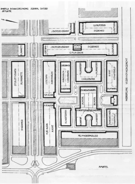
[image:27.595.106.494.375.667.2]For Java Island, the city’s planning department carried out a preliminary study, formulated the development brief and produced a model plan. This development brief stipulated, among other things, that the development was to be situated parallel to the quays in order to exploit the view over the IJ to the full. Because there was no space on the narrow island for a wide central road, car traffic had to be routed via the north quay. Bicycle traffic was to be routed over a cycle path through the sheltered, less windy central area. Another important part of the development brief was the so-called Woonatlas, the Atlas of Living, produced by the city of Amsterdam, which described concepts of living.