PAPEHS AKD PIWCEEDIKi;S 01<' THE _!{OYAL SOCIETY OF' TASMA~IA, VOLl ___ ,;\JE !-HI.
GEOMORPHOLOGY OF THE BUCKLAND BASIN, TASMANIA
By
A. GOEDE,
Department of Geography, Australian National University.
(With 1] lext f,gures.)
ABSTRACT
The Buckland Basin is an exhumed tectonic basin considerably modified by erosion. Its drain-age pattern has been altered by river capture. A longitudinal profile of the Prosser shows that the basin is not graded to present day sea level. The theory of the effects of changes in base level is considered. Erosional terraces are described which may be due to Pleistocene glacio-eustatic oscilla-tions in sea level.
The morphology of the floodplain is examined in detail. Types of river channels and the nature of the floodplain alluvium are discussed. Surface morphology of the aggradational Turvey Terrace indicates that the terrace was formed under climatic conditions very different from the present. Depressions on the terrace may be thaw sinks. .Measurements of a fossil stream on it, the prior Tea Tree, indicate much larger bankfull discharges. Alluvial fans which may be related to the Turvey Terrace occur along the Eastern Boundary Scarp of the basin.
An attempt is made to interpret and date the alluvial deposits. Aggradation in the basin is probably due to climatic factors causing a change in the load-discharge ratio of the streams. Differ-ences between floodplain and Turvey alluvium are shown. Floodplain alluviation is believed to be due to a mid-Recent period of increased aridity, while the Turvey alluviation is periglacial in origin.
INTRODUCTION
The Buckland Basin is located near the East Coast of Tasmania some forty miles north-east of Hobart,. Measuring approximately five miles from west to east and almost the same distance from north to south, it is approximately triangular in plan. On the eastern side it is bounded by a steep scarp, interrupted only where the Prosser River leaves the basin. Steep undercut slopes form a distinct boundary to the north-west. To the south-west the edge of the basin is defined by a row of steep dolerite hills reaching their highest point at Mt. Gatehouse.
As a background to a consideration of the nature and origin of the basin itself, it is necessary to extend the discussion to the whole of the Buckland one inch to one mile topographic sheet. To the south and west the watershed of the drainage basin of the Prosser and its tributaries falls within the sheet whereas to the north the watershed falls out-side it. No contoured maps are available for the area to the north.
138
THE CONTEXT
Climate, vegetation and soils.
The average yearly rainfall in the Buckland Basin and along the coast ranges from 20 to 30
inches (Nicolls and Aves, 1961). In the more elevated regions the rainfall is higher, probably between 30 and 40 inches. It is fairly evenly dis-tributed throughout the year although there is a slig~ht tendency towards a winter rainfall maximum. The mean annual temperature is probably in the vicinity of 52' F. River valleys and basins ex-perience severe frosts in winter. In Koppen's system the climate is classified as Gfb.
The vegetation is similar to that of the 80rell-Carlton-Copping area, immediately to the south where it has been described by Loveday (1957), He found that the vegetation could be divided into three major groupings depending on rainfall. Savannah woodland is characteristic where rainfall is less than 25 inches. With rainfalls from 25 to
30 inches a dry sclerophyll forest develops, while areas with rainfalls exceeding 30 inches may be classified as wet sclerophyll. There is a continu-ous grada,tion between these vegetation classes.
The savannah woodlands are mostly cleared unless they are too steep or stony for cultivation. Dry sclerophyll forests are mostly in the natural state except where undergrowth has been cleared to allow rough grazing by sheep. Wet sclerophyll forests are found in the higher rainfall areas, in the Prosser's Sugar Loaf-Middle Peak area to the south-east and around Blue Tier to the north of Buckland as well as in moist sheltered valleys within the drier regions.
The soils of the Buckland Sheet have been des-cribed by Loveday and Dimmock (957), who pro-duced a, reconnaissance soil map on a scale of 1 inch to the mile. The main soil divisions are based on differences in lithology. Podzolic soils on sand-stone, feldspathic sandsand-stone, mudstone and dolerite are described, and in addition there a·re small areas of brown and black soils on dolerite as well as krasnozems, black and red-brown soils on basalt. The only soils of large areal extent are the pod-zolic soils on dolerite (251 sq. miles) and sand-stone (79 sq. miles). Soils of alluvial deposits (30
134 GEOMORPHOLOGY OF THE BUCKLAND BASIN.
alluvial soils derived from sandstone and dolerite. In the latter there are also important differences between the soils of the present floodplain. the Turvey Terrace and the fans. These differences will be discussed later.
Lithology
The oldest rocks outcropping in the area (Department of Mines, 1958) are flat-lying to gently dipping Permian marine mudstones of the Malbina Formation (formerly known as the "Woodbridge glacials"). They are exposed along the course of the Prosser River downstream from the Buckland Basin and also to the south of the Tea Tree Rivulet just before its confluence with the Prosser. The mudstones are overlain by a thick sheet of Jurassic dolerite. Due to their limited outcrop of approximately one square mile the Permian rocks are of little importance in the geomorphology of the Buckland Basin. Their sus-ceptibility to fluvial erosion is similar to that of the Triassic sandstones.
Triassic rocks outcrop extensively in the region, occupying a roughly wedge-shaped area with the point of the wedge formed by the Buckland Basin. They have been mapped as two units: (1) The older Ross Sandstones and Knocklofty Sand-stones and Shales. (2) The younger Feldspathie Sandstones and New Town Coal Measures. The use of these formation names is very questionable. In discussing the Triassic System in Tasmania, Hale (962) has already pointed out the difficulties of correlating strata even over short distances. This is due to rapid horizontal variations in thick-ness and lithology, repetition of similar beds and the lack of marker beds and fossils. The Buckland region is a considerable distance from the Triassic type sections and the lithology of at least part of the succession is rather different. (1) The older " Ross Sandstones and Knocklofty Sandstones and Shales" consist in part of a succession of several hundred feet of cross-bedded sandstones rich in halite and epsomite. These salts are very sus-cetPtible to chemical weathering and, where slopes are steep, shallow caves are formed by atmospheric weathering in layers rich in these salts. The unit as mapped also includes sandstones with thin bands of shale. The latter contain poorly preserved plant fossils and outcrop in one place along the bank of the Prosser in the Buckland Basin (grid ref: 560540), (2) The younger" Feldspathic sand-stones and New Town Coal Measures" outcrop in two small areas only: one along the Back River near "Stonehurst" and the other at Tiger Hill between the Bluff and Sand Rivers. The rocks consist of sandstones and shales containing bands of coal up to three feet thick. Both areas have been mined for coal on a small scale 50 to 100 years ago.
From the geomorphological point of view only the rocks discussed under (1) are of real import-ance. They underlie the Buckland and Runny-mede Basins and occupy large areas to the north and north-east especially in the drainage basins of the Bluff and Sand Rivers. The Triassic sand-stones are more liable to weathering and erosion than the Jurassic dolerite thus partly explaining
their coincidence with basins. However, to the north and north-east of the Buckland Basin they outcrop in country of strong relief where the upper courses of the Bluff and Sand Rivers have cut deep gorges.
The Jurassic period is represented by thick sills of dolerite, which are intruded at various levels into the Permian and Triassic strata. Individual sills may be 1000 feet or more thick. They are often transgressive, hence cannot be used as stratigraphic markers. As well as sills there are dykes and necks of dolerite. This rock occupies by far the greatest area on the Buckland Sheet. The Buckland Basin is bounded by extensive areas of dolerite to the west, east and south. The most resistant rock, it
outcrops in nearly all the higher country. This is so despite the fact that it is susceptible to both chemical and physical weathering. It is composed mainly of two minerals: augite and labradorite both of which are susceptible to chemical weather-ing. Physical weathering is promoted by the well jointed nature of the rock making it particularly vulnerable to Irost wedging under periglacial con-ditions.
Tertiary freshwater sediments are also repre-sented in the Buckland Basin although they are nnt shown on the geological sheet. The presence of Tertiary sediments was flrst suspected by Loveday and Dimmock (1958) who produced a reconnais-sance soil map of the Buckland Sheet. They des-cribed an area of lateritic soils (1 sq. miJe) in the
Buckland Basin stating that these were "con-sidered to have been developed on lake sediments similar to those of the Launceston Tertiary Basin, with which the soils have much in common". An outcrop of these sediments was discovered by the writer who found light grey clays, underlying Quaternary terrace and floodplain deposits, in the bed of the Tea Tree Rivulet UD to three feet above low water level (plate 3). This outcrop is inter-mittent for a distance of several hundred yards but the most extensive outcrop occurs a,t grid ref. 597516 just north of the boundary fence between Court Farm and Mr. Turvey's property. The clays contain abundant vitrinized fossil wood and lenses of paper coal up to 6 inches thick, interbedded with thin s,andstane beds. Polished sections show that the clay is laminated. The lamina,tions are wavy and one layer of clay between two sandstone bands showed strongly convoluted laminations. Deform-ation of the clay laminDeform-ations is probably due to post-depositional compaction. The sediments are fla:t lying and are not jointed. In one outcrop root voids penetrate the top six inches indicating the presence of vegetation before the deposition of Quaternary alluvium. An auger hole (t) was put down in the bed of the Tea Tree Rivulet and went through 4' 4" of clay with three bands af sandy material before striking a log of vitrinized fossil wood.
The age of the days is critical to the interpreta-tion of the evoluinterpreta-tion of the Buckland Basin. Town-row (in press) has found a rich flora, including abundant conifer remains, and has already des-cribed the following new species from the 10caUty:
Podocarpus strzleckianus, P. tasmanicu3, P. setiger, P. goedei, P. acicularis, and Microstrobos
A. GOEDE.
~.,
~
. / / ... ORFORD BayP"""
RI'"Y ( / \
~ .. >,--____ ):;'- . ~~~ .. ( PrOllllflr---~~-.--~--. -~-;:;;---~=----.
~2~""- 5-~~7~R""
-..aslf) ~ ~ 'ro~nfL -
))iSS
055-4 6.30$37 63 oR1J
051 510
0- '"
w---E Seismogl'oph survey .p Aug~r nO(Q
Sample stff}
Sedlmflflt sample
Rock sump("
r
, oR! .,
r'~
"'00\
L
___ _
Roado FEET 5000
~ _ _ _ .-1
Fw. 1.--1ndex and ~ample map of the Buckl::Jnd Basin.
molinae and a species of Athrotaxis. Coronelia molinae had previously been recorded only from the Eocene of Chile (Coronel, Buen Retiro) where
it was described by Florin (1940) as a new genus and species. Some mat.erial was sent fOT pollen analysis to Dr. Duigan (University of Melbourne), who found that most of the pollen belonged to
Nothofagus. Several species were present including
N. emarcida, N. cincta, and either N. goniata or a closely allied form. N. cincta is recorded from Eocene to Lower Miocene and N. goniata from the Lower Tertiary. Other angiosperm pollen grains included those of Proteaceae and Casuarinaceae but myrtaceous pollen grains were not observed. There was also an appreciable amount of gymno-sperm pollen probably belonging mainly to the Podocarpaceae but including Trisaccites micropteris
and Ephedra notensis. Both of these have been recorded only from Lower Tertiary and earlier deposits. In Tasmania they have also been identi-fied in the Launceston Tertiary Basin in sediments of Palaeocene-Lower Eocene age CGill and Banks, 1962). The combined evidence of plant macro-fossils and pollen analysis strongly suggests an early Tertiary age.
136 GEOMORPHOLOGY OF THE BUCKLAND BASIN.
t
o FEET 5000
[image:4.514.110.433.67.618.2]A. GOEDE. 137
Small flows and necks of Tertiary basalt out-crop two miles south of Buckland near Sally Peak and also in the Runnymede Basin, neal' Nugent and in the vicinity of Oriel ton and Pawleena.
Quaternary sediments occur along the coast and along the rivers especially in the Buckland Basin. The fluvial sediments of the basin will be discussed later.
Stnwiure
The area ha~ been faulted in the Tertiary in two dominant directions~-·
(1) A north-south direction with faults bound-ing the horst that runs parallel to the east coast. The westernmost fault has given rise to a promin-ent scarp, 8 miles long, which forms the eastern boundary of the Buckland Basin and is called here the Eastern Boundary FaulL
A northwest-southeast direction with faults to the west of the Eastern Boundary Fault and appearing to terminate against it. They are ten-sional faults forming a complex graben.
Since the northwest-southwest trending faults appear to terminate against the Eastern Boundary Fault they are unlikely to be older than the latter.
If both directions of faulting are of the same age the pattern can best be explained by regarding the north-south running faults as sinistral shear faults associated with tension faulting at an angle of approximately 40° to 50°. From aerial photo-graphs all lineations in the dissected area to the east of the Buckland Basin were plotted on a map (fig. 2) and it would appear that the Eastern Boundary Fault of the Buckland Basin is associated with a number of strongly curved and splayed fractures. This association suggests that the fault is not a tensional one. It is most unlikely that the curved fractures are cooling joints since in the dolerite these tend to either straight or only gently curved. If the fault is a shear fault, the curved fractures are best explained as small thrusts. A third possibility is that the northwest-southeast faults are younger than the Eastern Boundary F'ault. Both directions of faulting pre-date the formation of the Nugent Surface, an erosion surface standing at a height of 1100 to 1200 feet above sea level.
The relationship of the faults to the Tertiary sediments is important but not clear. The Tertiary sediments exposed in the bed of the Tea Tree are no more than 2000 feet away from the Eastern Boundary Fault. Had they been deposited before
2700
20GO
o MILES 1 L_~_L-_J
[image:5.513.45.479.317.610.2]138 GEO:l!OEPHOLOGY OF THE BUCKLAND BAS1N,
north-south faulting began one would have expected to find evidence that the beds were
dis-turbed, Yet they are fiat-lying and unjointed,
It is therefore likely that they postdate the Eastern Boundary Fault, The relationship of the Tertiary sediments to the northwest-southeast trending faults is unknown, Whether or not the two directions of faulting are of the same age they provide a \vay in which the Buckland Basin could have formed as an enclosed tectonic basin, The Tertiary freshwater sediments which outcrop in the Tea Tree Valley could well represent the remnants of the infilling of such a basin, Their character suggests that they are lacustrine rather than fluvial sediments, If the Tertiary clays represent the infilling of the Buckland Basin during and after its formation, their early Tertiary age indicates approximately the date of at least one period of faulting, It is generally recognised that the early Tertiary was a period of major faulting in Tasmania, The character and extent of Tertiary faulting in eastern Tasmania is generally difficult to determine because of the prevalence of Jurassic dolerite and Triassic sand-stones, neither of which provide suitable marker horizons,
EROSIONAL MORPHOLOGY Relief
A generalized contour map (fig, 3), summit con-tour map and a summit frequency graph (fig, 4) were constructed from the Buckland topographic sheet, Since the generalized contours and summit contours give similar results only the generalized contour map is shown, Although summit con-cordance is lacking over much of the Buckland Sheet, it is marked over a considerable area to the west of Buckland and to a lesser extent around Nugent, This is reflected in the summit frequency graph showing a very marked peak at 1,100 to 1,200 feet, Much smaller peaks occur at 2,100 to 2,300 feet, 1,800 to 1,900 feet and 600 to 700 feet possibly indicating other erosion surfaces, The one at 1,100 to 1,200 feet is by far the most pro-nounced and is here called the Nugent Surface,
It shows no evidence of having been faulted and since it is fairly widespread and in places very weli preserved it is safe to say that no significant faulting has taken place since its formation, The surface is developed across both dolerite and Tri-assic sandstone but is best preserved on the more resistant dolerite, its extensive development on dolerite must have required a long period of time, However, the surface may at least in part be a structural one formed by the stripping of less resistant overlying sediments from the top of a dolerite silL Since the area was affected by Tertiary faulting it seems likely that stripping was at best only a minor factor in its development, The surface is characterized by low, rounded hills and broad, flat-bottomed valleys which are fre-quently dry, As in the Buckland Basin, they may have been partly filled in by alluviation and the actual rock surface may not be as flat as it would appear.
Of the five surfaces postulated by Davies (1959) only his higher coastal surface seems to be present on the Buckland Sheet. Davies and the writer
(fig, 4) have both produced summit frequency graphs showing a strong peak at 1,100 to 1,200 feet, which is slightly lower than the usual range of 1,200 to 1,500 feet given for the higher coastal surface, The lack of contoured maps for areas surrounding the Buckland Sheet makes it impos-sible to tell whether the 1,100 to 1,200 feet surface is continuous with similar surfaces at a slightly greater height in the Lower Midlands, To the west of Buckland it is separated from them by a con-tinuous ridge extending from Black Charlie's Sugar-loaf to Mt, Hobbs and forming the water-shed between the Prosser and Coal Rivers, The Nugent Surface could be a separate surface related to an earlier phase in the history of the Prosser and its tributaries,
Origin of the basin
In flrst analysis it would appear that the basin was erosional in origin, excavated in the easily weathered Triassic sandstones which occupy its floor, surrounded on three sides by more resistant dolerite, However, a completely erosional origin is now ruled out by the discovery of Tertiary clays in the Tea Tree Valley, The evidence suggests that the basin is basically tectonic in origin and that the faulting which led to its formation predates the development of the Nugent Surface, If the basin formed as an enclosed basin as postulated it must have been a lake of considerable extent at the clos:: of the faulting, This lake was filled wHh sediment derived largely from dolerite terrain, probably during the early stages of the development of the Nugent Surface, At this time the Prosser may have flowed out between the Three Thumbs and Prosser's Sugar Loaf to enter the sea near Rheban (fig, 3) to be captured later by a smalier stream extending its drainage area inland from Prosser Bay,
A series of ne:;ative changes in baselevel then caused the Prosser to become incised in its new lower course while simultaneously causing it and its tributm'ies to cut rapidly into the unconsoli-dated lake sediments which had filled the Buck-land Basin to an unknown height. The Tertiary clays are particularly susceptible to stream erosion and the probabiHty of finding remnants of these beds at higher levels is remote, The clays out-cropping in the bed of the Tea Tree Rivulet and also underlying the "Ironstone Surface ", appeal' to be remnants of a more extensive lake sedi-mentation, The pronounced dolerite scarp form-ing the eastern boundary of the Buckland Basin is regarded as a resurrected fault scarp due to the removal of Tertiary sediments from the basin,
Drainage
so
so
40
>-( ) z w
=>
cr W 0::
LL
!:::: 30 ::E
.~
=>
U'l
20
10
400 too
A. GOEDE.
~
Prosser Drainage BasinD
Remainder of Buckland Area1200 1600 2000 2400
FEET ABOVE SEA LEVEL
FIG. 4.--Summit fl'eque:1cy graph of Pl'o3ser drainage basin and Buekland Sheet.
[image:7.520.58.438.61.609.2]140 GEONlO[{PHOLOGY OF THE BUCKLAND BASIN.
There have been several river cantures. The Saud River apparently once jOined the Bluff River about .five miles north of Buckland before being captured by a stream draining directly into the basin. The evidence for this is a distinct gap in the ,vatershed betwecn the Bluff and Sand Rivers. the floor of which is now approximately 200 feet above the present beds of the two streams. A classic example of river capture is found in the case of the Bluff. This river once fiowed down a broad, dry valley-now followed by the L,evendale Road--to join the Prosser just west of Buckland.
It has since been captured by a small stream draining directly into the Buckland Basin thus creating a perfect elbow of capture. The river has now cut down about 50 feet below the windgap representing its old course. Immediately down-stream the steep valley walls indicate strong in-cision after capture due to the sudden increase in erosive power at this point. Reversal of drain-age has barely begun; there is a very short, shallow gully extending to the windgap which will eventu-ally develop into a reversed stream. The upper part of the dry valley just below the windgap is rather swampy in nature.
The Prosser may once have flowed to the south of Buckland where it joined the Brushy Plains Rivulet before cutting its present course further north. The area through which the stream may have flowed is shown doubtfully as an old channel fill on the river terrace map (fig. 7) but no undoubted fluvial sediments have yet been found there. The area is fairly flat and stands at a height of 45 to 65 feet above the bed of the Prosser. Most of the soils appear to have been developed on colluvial material from the steep sandstone hills immediately to the south or on bedrock sand-stone. Deep, strongly podsolized sands are found 300 yards sout!h of the Tasman Highway bordering the road to Sally Peak. As these might be fluvial sediments four samples (81-4) were collected for analysis. The method employed was that by Folk and Ward (1957). The mean size of the samples varied from .164 to .209 mm. (fine sand). They are moderately sorted, posit,ively skewed and lepto-kurtic tD very leptokurti!c (excessively peaked). The percentage silt and clay present varied from 5.4 to' 12.1 %. The mean Wadell sphericity for 25 grains chosen at random from each sample ranged from
.804 to .815. The sediment analyses permit but do not require a fluvial origin for the sand. There-fore it is distinctly possible but not proven that the Prosser once flowed south of Buckland.
Longitudinal profiles
It is probable that significant faulting has not taken place since the early Tertiary and certainly not after the development of the Nugent Surface. Hence irregularities (Uickpoints) in the longitudinal profiles of the Prosser and its tributaries cannot be attributed to faulting. Such nickpoints are there-fore due, either to irregular changes in discharge, channel characteristics and load or to changes in base1evel, i.e. changes in the relative level of land and sea. One has to consider how the graded river in the sense of Mackin (1948) is affected by the lowering, rising or stability of baseleveL Mackin's definition of a graded stream is "one in Which,
over a period of years, slope is delicately adjusted to provide, with available discharge and the pre-vailing channel characteristics, just the velocity required for transportation of all the load supplied from above". He also states that" slope usually decreases in a down valley direction, but because discharge, channel characteristics and load do not vary systematically along the stream, the graded profile is not a simple mathematical curve".
(1) Lowering of baselevel.
When the baselevel is lowered the mouth of the stream is normally displaced both ve:rtically and horizontally. There are three
cases--(aJ If the slope of the newly emerged land is steeper than the gradient required for the river, the velocity of flow in this section will be accelerated resulting in down-cutting and the steepening (nick-point! will be propagated upstream. The initial slope of the nickpoint will depend on the slope of the emerged land surface, (b) If the slope of the newly emerged land is the same as the gradient required for the river the graded profile will not be affected.
(c) If the slope of the newly emerged land is less than that required for the river the velocity of flow in the lowest part of the river will be reduced and ,aggradation will occur. The flattening will be trans-mitted upvalley causing a wave of de-position.
Thus lowering the baselevel does not necessarily lead to rejuvenation. It does so only if the slope of the emerging land is steeper than the gradient required by the river to maintain its graded profile. The importance of the slope of the emerg-ing land in this respect has already been pointed out by Sparks (1960). The Davisian idea tha;t lowering .of baselevel always gives rise to re-juvenation has also been criticized by Simons
(1962) who in discussing Penck's work sta,ted that: "Davis assumed a simple relationship between rates of upheaval and rates of river erosion. It is .obvious .if we accept the principle of nickpoint retreat that there is no simple rela,tionship between changes in baselevel and river downcutting. A change of baselevel can only give rise to a nick-point if it causes a discontinuity in the graded river profile.".
(2) Rise of baseleveL
Following Mackin many workers have suggested that a rise of baselevel causes aggradation. Mackin
A. GOEDE. 141
V.E. = 528
L_--~~,---'----'---'----'---'i----'i---.---r----Ti---ri ----Ti---r----Ti---,·~
12 14 20 22 M 25 ze ~
DISTANCE IN MILES
FIG. 5.-Longitudinal profiles O'f the Prosser and its tributaries.
deposition". Mackin supports his statement with examples of reservoir dams and debris barriers causing upstream aggrad8ltion in United States rivers. But from his own paper it is clear that it is not the dam itself which causes aggradation but the progressive regraiding of the delta which begins to build out into the reservoir once it has been filled. It is not the rise in baselevel which causes aggradation but the bui1ding out of a delta when baselevel has ceased to rise. Applying this to strea;ms in relation to sea level one can say that the rise in sea level since the last glaciation did not cause aggradation because it prevented river deltas from emerging. It is only since the postglacial rise in sea level was completed that river deltas began to build out. Contrary to Mackin the writer believes that a rising sea level does not cause ag-gradation but is the ideal condition for the rivers to maintain their graded profile.
(3) Stability of baselevel.
Under these conditions rivers are likely to build out deltas unless prevented from doing so by long-shore or other ocean currents. The building out of a delta will cause aggradation upstream in a similar manner to that in reservoirs, but since the gradients of all larger rivers are usually low near their mouths the effects of such aggradation may be only slight.
The maintenance of a graded profile during a considerable period of time is required for the development of a rockcut surface, whether formed by pan- or pediplanation, especially where a stream flows over resistant bedrock. Hence a period of rising baselevel is more favourable to the develop-ment of rockcut surfaces than a stationary one. Such surfaces can however form with a stationary baselevel provided little or no aggradation takes place due to delta building at the mouth. When
the development of rockcut surfaces is interrupted by a period of downcutting resulting from a lower-ing of baselevel and the consequent upstream migration of a nickpoint, the surfaces are trans-formed into rockcut terraces.
[image:9.514.39.478.59.280.2]142 GEOMORPHOLOGY OF THE BUCKLAND BASIN.
available by the Rivers and Water Supply Com-mission. Altogether the height of the Prosser was established at seventeen points over a distance of less than fourteen miles. The height of the Tea Tree Rivulet W3;S determined at two points: one of them at Gatehouse's Marsh Bridge. The profile of the Tea Tree upstream from the bridge was also surveyed for 6000 feet us'ing a staff and Abney level. The results are set out in fig. 6, where the heights given refer to low water stream level. Distances along the Prosser and Tea Tree were measured on aerial photographs. The profile of the Prosser is a smooth curve from the upper end of the Buckland Basin down to Brockley Bridge. There are three nickpointsin the profile: the first at Brockley Bridge, the second half a mile above the weir and the third about a mile upstream from the Prosser Dam. The nickpoint at Brockley Bridge appears to have no cyclic significance since the rock-cut Buckland Terrace maintains the same height above the river above and below this point. The Bluff, Sand and Back Rivers join the Prosser immediately upstream and the steepening of the
300
V.E.
=
211·2
250
200
gradient may be due to adjustment to the heavy load of sand carried by these rivers. The nick-point half a mile above the weir is probably cyclic. Terraces below it cannot be correlated on the basis of height with those in the Buckland Basin (fig. 7). The third nickpoint about a mile upstream from the Prosser Dam is a very marked one. It occurs at a he'ig'ht of about 70 feet and from this point downstream there is a steep gradient to the tidal reach of the river except for a break of slope just above the Prosser Dam giving the nickpoint a stepped appearance. It is also interpreted as a cyclic nickpoint, since there appears to be no other reason for the sudden steepening of the profile. There is no evidence of recent faulting along the coast which could have initiated the lower two nickpoints and it is suggested that they are due to intermittent lowering of baselevel, which may have been epeirogenic or eustatic or a combination of both. The nickpoints may well be glacioeusta'tic-due to the lowering of sea level during Pleistocene glacials.
Levendale Rd.
Mace's
Bridge I
I I
Bridge ,
--.J Prosser -Tea Tree I
W
>
W
--.J
<l: w
en
w 150
> 0 OJ <l:
f-W W ll.
100
50
tidal
-o
wair
Prosser
Dam
2
Confluence I I
rea Tree Rivulet
I I I I I I
Brockley Bridge
I
I
6 8
I
I I
~
DISTANCE IN MILES
10 12
FIG. 6.-Longitudinal profile of the lower courses of the Prosser and the Tea Tree Rivulet.
[image:10.514.50.483.267.621.2]A. GOEDl';. 143
An interesting f2ature of the profIle of the Tea Tree Rivulet is that it passes below that of the Prosser just above the 'confluence although the former is a much smaller stream. The Tea Tree here flows through an area known as Gatehouse's Marsh and is actively aggrading its fioodplain although vigorous downcutting occurs further up-stream. Deposition in Gatehouse's Marsh may be due to a recent increase in load resulting from rapid guIlying further upstream, aided by the damming back of the floodwaters of the Tea Tree by those of the Prosser. The floodplain of the Tea Tree is as much as 5 feet below that of the Prosser just above the confluence. The Gatehouse's Marsh situation may be analogous on a small scale with the Lowbidgee area on the Murrumbidgee River before it joins the Murray (Langford-Smith, 1960).
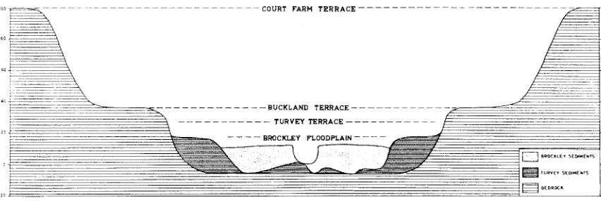
Erosi::mal terraces
Two or possibly three erosional terrace levels can be recognised in the basm. They are: the Buckland Terrace at 30 to 40 feet, the Court Farm Terrace at 70 to 110 feet, and a possible higher level at 170 to 240 feet above river level (fig. 7). The height of the Buckland Terrace was established by trans-verse profiles surveyed by level and staff. Abney level and aneroid were also used. The heights of the Court Farm Terrace and a possible higher level have been established by aneroid 'Only. All heights are given as heights above low water level of the nearest river. It was found that below the nick-point half a mile upstream from the weir, terraces could not be correlated with those of the basin on the basis of height above river level. There is a rockcut terrace at 60 to 80 feet which may cor-respond to the Buckland Terrace and a lower terrace at 30 feet. Heights are indicated in fig. 7.
The Buckland Terrace is fairly extensive and remarkably fiat. It is particularly well developed the Prosser maintaining a constant height of 40 feet above the river throughout the length of the basin, and is cut in Triassic sand-stones, Permian mUdstones and Jurassic dolerite. On the dolerite it is much less extensive but par-ticularly well preserved. No fluvial sediments have been found on the terrace. The soils appear to have been derived from .the underlying ljock. Pod sols are well developed on sand- and mUdstones and may have buckshot gravel in the profile but on dolerrte they are thin and stony. Where the terrace is developed on Triassic sandstone it locally has on its surface shallow depressions due to wind defiation, two of which are quite large. One is found a short distance to the east of Buckland. It is approximately 900 feet long and up to 470 feet wide, elongated at right angles to the prevail-ing wind and backed by a low lunette. A sand sample taken from the windward side of t,he lunette (S8) was found to be moderately sorted with a mean size of .155 mm. The lunette is rather irregular in plan and has a vegetation of scattered eucalypts up to three feet in diameter with an undergrowth of cutting grass and bracken fern. The sand of which the lunette is composed has been leached. The depression has a mottled brown and darl~ grey clayey floor in contrast to the sandy soils surrounding it. On the western (windward) side it is rather irregular in outline. while the
eastern side forms in part a smooth curve. It was formed by west-north-westerly winds which are still prevailing at the present time. The depression is located in line with the gap cut through the dolerite by the Prosser just north of Buckland. The other wind-blown depressions are found just west of the road to Brockley before it crosses the Prosser, the largest of these being 670 feet long by 370 feet wide. The eastern side is a curve concave to the wind, and there is no lunette. The other depressions are all much smaller and very shallow one showing a curve concave to the wind with arms trailing to windward making it crescent shaped in plan. None of them are backed by lunettes and all indicate prevailing westerly winds.
It seems likely that the depressions were formed during a time more arid than the present as some have been ploughed without being activated. They may have formed by deflation of the sandy A-horizon of the soil during a more arid period or could even be the result of drier conditions com-bined with destrudion of vegeta'tion through burn-ing off by the Tasmanian aborigines.
The Court Farm Terrace stands at 70 to 110 feet above river level. It is most extensive around Buckland and in general appears to have been stripped of any fluvial sediments it may have had.
North-west of Buckland is the dry valley
144 GEOMORPHOLOC;Y OF THE BUCKLAND BASIN.
FEET ABOVE RIVER LEVEL
s -1£
i"""
f)r"ckl~y F[ooriplctln 16 -20 Turyq Torrttc.30 -to Blickic.nd r~rrac. 70 -110 Court Furm r.rrac&
170<),0 ~ Summllil anri Sho(.(ltfllfg 4S- 65 ~ Old Chan".: FlU?
c=J AI/uri'll FafHi
o FEET 5000
L -___ -'-_ _ ----1
Fro. '7.--Distribution and -extent of floodplain and river terraces in the Buckland B:-u3in.
level by slope wash. the ferruginous hardpan was broken up and some of the larger fragments left behind. One specimen co:llected at Court Farm Hill had a distinct reddish colour and on X-ray diffraction analysis was found to contain hematite and quartz. Most of the ironstone however is limonite. The" Ironstone Surface" is at a slightly lower level than the Court Farm Terrace further west but has been included as part of the t3rrace because the ironstone provides clear evidence that the surface has been degraded.
There is some evidence of remnants of a higher terrace between 170 and 240 feet above river level. Summits and benches cut in both dolerite and sandstone are well developed along the Brushy Plains at an approximate height of 200 feet (fig. 7) and. along the Tea Tree east of Court P'al'm. a bench is cut in dolerite at a height of 200 to 240 feet. South of the Prosser one mile south-east of Buckland is a marked break of sloDe between 160 and 190 'feet. They may all be remnants of a higher terrace but the evidence is not conclusive. The erosional terraces are believed to have formed during long periods of stream profile stability separated by times of rapid downcutting resulting from the upstream migration of nick-point.s. The origin of nick points has already been discussed.
ALLUVIAl, MORPHOI"OGY
Floodplain morphology
In the Buckland Basin the Prosser and itstribu-taries are assoeiated with a fioodplain wh~ch in places is more than half a mile wide. It has been named the Brockley Floodplain and its extent is shown in fig. 7. During heavy floods such as the one which occurred in April, 1960, the floodplain is converted into a temporary lake. When the water is low the flow is confined to a single channel but during floods more than one channel is oc-cupied as some of the rivers are braided. Braid-ing is well developed at the confluence of the Prosser and Bluff Rivers and on the floodplain of the Brushy Plains Rivulet.
The character of the load transported rivers depends on the lithology of their
A. GOEDE. 145
and the behaviour of streams under conditions of aggradation. Fragments of bog iron ore were found in the 'I'ea Tree Rivulet. They occur in gravel bars and also in the floodplain gravels and may be up to several feet across. They differ in several ways from fragments found on the" Ironstone Surface" (page 11). In some fragments iron oxide coats the surface of branches or roots of trees which them-selves have been replaced by fine-grained structure-less silica. The limonite coating has been deposited as a large number of small beads projecting from the surface suggesting deposition around bacterial centres. Other fragments consist of iron oxide cemented sediment showing hollows once occupied by st.ems and leaves while some are made of chemically deposited iron oxide showing a cellular structure. Some iron oxide from the surface of one of the fossil branches or roots was crushed for X-ray diffraction analysis. Since the iron oxide gave no pattern it was probably limonite. The only mineral which gave a pa;ttern was doubt-fully identified as manganese oxalate. Mang·anese is a common constituent of bog iron ores. The source of the bog iron is unknown. It may have been derived from swamps occurring at a height of 1700 feet one mile north of Prosser's Sugar Loaf, drained in part by tributaries of the Tea Tree Rivulet. This area has not been visited.
Three types of channels in the floodplain can be distinguished. They
are-( 1) :Meandering channels not yet affected by downcutting and characterized by their small width and irregular meanders. Some of these channels stilI carry low water flow. Examples are the chan-nels of the Tea Tree downstream from Gaitehouse's Marsh Bridge and the Prosser near its confluence with the Bluff, Others have been abandoned in favour of channels of type (2). Channels no longer carrying any flow or where the flow is insignificant are often choked with vegetation, An example which has been abandoned since the photograph was taken, oecurs in the upper Tea Tree Valley.
(2) Channels formed by gullying. They are a strikIng feature of the basin and are typically U shaped in cross section, being deeper than the mea.naering channels, with the alluvium standing up as verHcal cliffs. Low water level may be
any-thing from a few to 18 feet below the floodplain but averages 8 to 12 feet. There is usually little or no scrub vegetation along the banks. These chan-nels are much wider than the meandering ones and are relatively straight. They are usually formed by headward erosion, a minor exception being a small gully formed by forward stoping on the floodplain of the Bluff Rivm'. The channels are widened by slumping O'f the banks as they are undermined by floods. Gullying starts in suitable localities along the stream and during floods headward extensiO'n may be rapid. The head of a gully may be bulbous in which case it is usually occupied by a shallow pool or it may be branching (plate 2). AccO'rding to reliable IncaJ reports a gully in the floodplain of the Tea Tree (plate 2) was initiated 80 years agO'. In 1946, when plate 2 was taken, it had reached a length of almost two thirds of a mile by headward extension. In the 1960 flood the Tea Tree broke through intO' this new straight course abandoning tts older meandering O'ne. Because the gullies are relatively straight they have steeper gradients than the older courses and also have, at least initially, effi.cient cross-sections. Gullying is often promoted by the fact that many of the older courses oecupy the highest part of the floodplain. During floods the water spills over sideways across the floodplain and flows down the lowest point until it rejoins the river. It is here tha!t gullying is usually initiated. Since the lowest point of the floodpla;in is often at a jurwtion with a higher terrace, gullying fre-quently occurs at or close to the edge of the flood-plain (plates 1 and 2). There is a lim~t to the width of the channels. As the width becomes excessive longitudinal banks of sand and occa-sionally gravel are formed along the channel sides. These banks prevent further undercutting and the cliffs of alluvium start to degrade. The name " internal levees" is tentatively suggested as a suitaJble O'ne for these features. Three samples of levee sand from the Prosser (S 5, 9 and 12) and one from the Bluff (8 13) have been analyzed (fig. 1). One sample of sand (S 11) from the tidal reach of the Prosser was alsO' analyzed. The sands . are we'll to' mO'derately sorted with nearly
sym-metrical skewness. The exception is S 11 which is poorly sovted and negatively skewed. The differ-ent character of this sample is due to tidal influence.
COURT FARM T l ! R R A C E ·
-R.s.u.
BUCKLAND TERRACE .. . _
-- -- -- -- --. -- -- -- -- -- TURVEY TERRACE . ..
-~lURV[yS(OIIol[)HS ~a£OROCI\
[image:13.513.43.469.478.621.2]146 (~EOM()l{PHOLOGY OF THE BUCKLAKV BASIN.
( 3) Intermediate channels, They are meandering ehannels which have been rejuvenated instead of abandoned as in the case of type (1) but, except for their meandering habit, they resemble the second class.
The last two types of channels are very reminis-cent of the reeently cut arroyos of the Colorado Plateau and adjacent parts of the dry Southwest of the United States (Bryan, 1925, Leighly, 1936). The bottom 01 none of the channels reaehes down to the base of t;he fioodplain (Brockley) sediments except in a few plaees. The Tea Tree has cut down to Tertiary clays near the boundary fence between Court Farm and Turvey's property, while Triassic sandstone outerops in the bed of the Prosser River in at least three plaees.
Gravel bars are common in the beds of the streams exeept in the Bluff and Sand Rivers. They may form more or less straight across the bed or project into the stream from one bank at an angle such that the toe of the bar points downstream without reaching the opposite bank. In the latter case they are said to be skewed. Leopold and Wolman (1960) suggested that the oceurrence of bars in a straight river should correspond morpho-logieally to the point of infiection of a meander-ing channel and that the distanee between sue-eessive bars was eomparable to the wave length of meanders. They also stated that in some straight reaehes gravel bars assumed the form of lobate wedges sloping alternately towards one bank and then the other. In the Buekland Basin bars in the beds of the streams show no regularity in either their spacing or the way in which they are skewed. In skewed bars the coarsest gravel is found in the middle of the stream becoming finer and the bar higher towards the bank from which it projeets. The bars are usually separated by deep pools. In the upstream part of the Prosser before it enters the basin the pools often dry up in summer leaving an algal matte eovering the boulders. This matte may prevent erosion during fioods. The Tea Tree has cut through its fioodplain deposits in places and has exeavated deep pools in the Tertiary clays underneath while elseWhere the rivulet is eut,Mng through fioodpla,in clays. Here the stream has, during a period of low fiows, exeavated a one foot wide meandering channel in its bed with an interesting development of miniature meanders. At one plaee on the bank of the Sand River sand has been blown from the bed and has aeeumulated as a low dune with a steep lee slope slowly en-eroaching on the fioodpla'in vegetation.
Overbank deposition on the fioodplain is probably significant only in the Gatehouse's Marsh area discussed earlier. However, since 1963 was an e}Ctremely dry yea.r the basin has not been seen under flood eondrtions, overbank fiow oecurring only once-in July. It was found that deposition on the fioodplain of the Prosser was limited to small elongated mounds of sand deposited on the upstream side of gorse bushes whieh 10caHy dot the fioodplain. The greatest effect of the fiood was to build up the "internal levees" deseribed earlier. Afterwards the surfaee of the levees showed current ripples in places. The morphology of the fioodplain suggests that at present scour rather than deposition takes place. The fioodplains are marked by numerous lakelets always elongated
in the direction of fiow. They are particularly numerous and well developed on the fioodplains of the Brushy Plains Rivulet and the Prosser below Broekley Bridge. Unlike oxbow lakes, they are usually s,traight or only slighNy curved. Most of them are irregular in plan but on the floodplain of the Brushy Plains they are frequently wider at the downstream end tending to be tear-shaped. A few of the lakelets follow old stream courses and are rather sinuous. The lakelets are thought to be due to fioodplain seoul'. Where gullies are formed by headward extension some may be ineorporated in the advaneing gully. Seoul' lakelets also oecur in Gatehouse's Marsh (Plate 1) where at present deposition is dominant. Their outlines are less distinet and vegetational zoning is eharaeteristie indieating that they are being filled in. Plood-pla.in seour mU's,t have occurred in the not too distant past and it is possible that the reeent change to deposition has taken plaee because of an inerease in load due to rapid gullying further upstream.
Crevassing is shown by the Brushy Plains Rivulet just after its emergence from the hills. Here the fairly wide stream breaks up into a number of crevasses fanning out aeross the fioodplain where large quantities of gravel are dumped. The pJace of the wide stream is taken by a mueh narrower stream the ehannel of whieh is diseontinuous with the erevassed distal end of the larger stream. Crevassing appears to be the way in whieh the Brushy P,ains disposes of a sudden exeess of load. The reason is probably a rapid change in gradient combined with a sudden widening of the valley fioor.
Where the floodplain (Brocltley) sediments are exposed they have a charaeteristic section. Auger hole b in the fioodplain of the Prosser (fig. 9) gave the following profile:
0--1'9" dark brown loam, somewhat clayey from 9" to 1'2".
1'9"--5'10" black clay rich in organic matter. 5'10"-S'1" sticky yellow-bl'own clay.
8'1"-10'7" mottled grey and brown sand.
10'7"
+
gravels., GOEDE. 14.7
A problem in the study of the floodplain sedi-ments is to what extent diITerences in section are due t,o sedimentation or to soil development, The surface layer of dark brown loam shows sedi-mentary layering in some places at least, indicat-ing that some of the characters of the top horizon are not pedogenic, The floodplains of the BluIT and Sand RlVel'S consist of a thick deposit of sand showing a little podsol development with thin A and B horizons marked by slight changes in colour. The floodplains of the Back River and the Prosser below its junction with the BluIT and Sand contain a mixture of sediments derived from both dolerite and sandstone terrain.
In the Tea Tree Valley a refraction seismograph was used to determine the thickness of alluvium
(d Dury, 1962) on the i100dplain as well as the alluvial Turvey Terrace, overlying Tertiary fresh-water sediments. The locality chosen had the advantage that the survey couJd be started from a known section exposed in the banks of the Tea Tree Rivulet, The following seismic velocities were determined:
-Turvey alluvium-l,125 feet/second. Brockley alluvium--l,200 feet/second. Tertiary sediments-4,400 feet/second.
The large difference in seismic velocities between the TeI'tia.ry sediments and the alluvium made it relatively easy to determine the boundary between them. The results obtained from the survey are shown in figure 10,
The floodplain vegetation of t,he Prosser, Tea Tree and Brushy Plains was originally dominated by dense tea tree scrub. The floodplains of the Bluff and Sand Rivers were better drained and supported a more v,aried and open vegetation including eucaJypts. The floodplains were largely cleared during the first half of the 19th century and it is certain that most, if not all, of the gullying has occurred s,ince then.
Where the lowest point of the floodplain is away from the river and borders a higher ,terrace, underground percolation may occur. In the ca·se of the Prosser i100dplain it is indicated by the depression of the water table in auger hole c (fig. 9) ,
The river meanders cannot be analyzed quanti-tatively because of their irregular nature. There is a marked contrast between the ingrown mean-ders cut in bedrock in ;the upper reaches of the streams and below the Buckland Basin, and the alluvial meanders within it. The ingrown, rock-cut meanders have a very much larger meander length and amplitude than ,the alluvial ones. Although the rivers in the basin are confined ,to one channel duringti'mes of low flow they tend to use more than one channel during floods. In addition much of the flow tends to be dispersed over ,the floodplain causing any floodplain channel at bankful dis-charge to carry very much less water than a corresponding ohannel in an ingrown meander. Also many ingrown meanders have been partially inherited from an earlier cycle and may not be adjusted to present discharge.
Other alluvial landforms
In addition to the floodplain there is evidence of another period of alluviation in the form of an alluvial terrace-the Turvey Terrace, which occurs at heights of 15 to 20 feet above river level. It has been identified along the Tea Tree, Brushy Plains and Prosser Rivers but is best pmserved in ,the Tea Tree Valley. Near the Court Farm-Turvey bound-ary the rivulet is cut,ting into the edge of the terrace and a complete section is exposed, The Turvey sediments in !the section have a maximum thickness of sixteen feet and are underIain by Tertiary clays (fig. 10). Like Itlrose of the flood-plain the Turvey sediments are characterized by a variable thickness of coarse gravels at the base. These Turvey gravels are more consolidated than the Brockley gravels making iit possible to dis.tin-gUish them in the 1i.eld. Remnants also occur in the bed of the Prosser upstream from Buckland where they are overlain by Brockley gr·avcls. In the bed of the Tea Tree Rivulet the Turvey gravels form a resistant bar across the stream with a small waterfall. The basal Turvey gravels am overlain by a sequence of silty sands. A good section is exposed only along ,the Tea ·Tree. The tenrace has well developed soils containing a varia1ble amount of ferruginous gravel. Three auger hQles e, wand y (figs. 1 and 9) were put down to get an idea 'Of the soil profile and to collect samples for mechanical analysis. The following section was obtained in auger hole e.
0'--1'2" brown sand.
1'2"-2'7" yellow brown sand.
2'7n~-2'1l" light brown sand with numerous small pebbles.
2'11"-4'5" mottled brown sand with some ferruginous concretions.
4'5"--5'6" grey and brown mottled silt. 5'6"-15'2" grey and brown mottled sand. 15'2"-17'1" grey sand with sandstone
frag-ments near base. 17'1" sandstone.
Similar sections were obtained in auger holes w and y. The former penetrated 11' 4" of silty sands and was stopped by glra.vel while the latter reached a depth 'Of 7' 7" before striking rock.
From all three auger holes samples were !taken at one foot intervals for mechanical analysis. The sample numbers are shown on the index and sample map (fig. 1).
Grain size parameters were calculated using the method 'Outlined by Folk and Ward (1957) whose parameters have been modified from those of Inman (1952) to provide a more detailed coverage of bimodal and strongly skewed size curves making the method particularly useful ,for fluvial sediments. Folk and Ward established mathematical relat'ion-ships between mean size, sorting, skewness ·and kurtosis and showed bhat the relationship between them eould be depicted in a four-variate graph 0
148 GEOMORPHOLOGY OF THE BUCKLAND BASIN.
varied from 3.08 to 1.77 0 (,118 to .293 mm,). The standard deviation ranged from 1.035 to ,2.345 0,
indicating Ithat the sediments are poorly to very poorly sorted. Skewness ranged widely from -.164
to .5340. One sample was negatively skewed and four were nearly symmetrical while the remaining twelve were positively to very positively skewed. KUl1tosis mnged .from 1.31 to 2.61 0, all samples being leptokurt'ic to very leptokurtic. The ,analyses show a direct linear relationship between mean size and skewness. Folk and Ward found that skewness and grainsize are closely related and that the 'relationship is sinusoidal. However, within the mean size range of the samples analyzed ,the relationsh'ip becomes approximately linear.
In interpreting the results one has to take into
consideration the effects of post-depositional
changes due to soil development. The increase in mean size from 3 to 6 .feet in depth is due to the fOl'ma;tion of iron oxide nodules in the soH profile. Their formation has also affected the standard deviJatron (sorting) and skewness. With the forma-tion of :the nodules sorting becomes poorer and the skewness tends to' change from positive ,to negative. Soil processes must ,also have affected the distribu-t'ion of the silt and clay content suggesting that the relatively high concentration between 4 and 11 feet is at least in part due Ito downward leach-ing of clays.
Where the Turvey Terrace has not been dissected its surf,ace is undulating. In the Tea Tree Valley it is covered with circular to slightly elliptical depressions, a single depression has a trilobate plan
in the photograph (plate 2). They are quite
shallow, being never more than a few feet deep and :tend to be swampY,though most of them have been 'artificially drained by trenches. The largest and best example has been deepened to serve as a watel1hole for stock and is appro~imately 180 feet long and 110 feet wide. The smallest de-pression is no more than 30 feet across.
Their origin is not known with certainty. They are unlikely to be wind-deflated hollows as, quite unlike the wind-deflated depressions on the Buck-land Terrace, they show no preferred orientat'ion. They cannot be karst phenomena as the Turvey sediments in which they occur are underlain by Tertiary clays while ,their shape in plan rules out a fluvial origin. The most likely expIanation is ,tha;t they ,are thaw sinks formed under periglacial conditions. Similar featUTes have been .found in Alaska (Hopkins, 194'9) and France (Pissart, 1958).
Pissart described more than 4,500 enclosed de-pressions south of Paris and suggested that most of them had a periglacial origin. Because they lacked annular mounds he thought that they were not reUcts of pingoes (Pissart, 1956), but thaw sinks of a different kind. The vast majority of his depressions are circular to 'Oval in plan, quite shallow and ,comparable in size with those found in the Buckland Basin.
The depressions in ,the Tea Tree Valley are approximately 200 feet ,above sea level whereas
Loveday and Dimmock (1958) estimate that the
downward limit of solifluction deposits is about
1,500 feet. However, periglacial activity 'is not just a function of height. The Buckland Basin is an enclosed basin surrounded on all sides by higher
country (fig. 3) and in winter severe frosts occur due to marked temperature inversions. During the Pleistocene ice ages, frost action in the basin could have been sufficiently severe for permafrost to occur. In a discussion of thermokarst features in Alaska, Pewe (954) found that permafrost occur-red on the floodplains and alluvial fans while absent or insignificant on surrounding hill slopes. This also suggests that temperature inversions are impol'tant 'in the location of permafrost.
In the Tea Tree Valley just south of the Tasman Highway the Turvey Terrace shows evidence of an old stream bed of much larger dimensions than the present rivulet (plate 1). This prior stream can be traced for approximately two thirds of a mile and is sufficiently well preserved to permit the measurement of Ithe channel width as well as the wavelength and amplitude of the meanders. The
measurements were made from plate 1 and are
approximate since the scale o.f the photograph is no.t known with a;bsolute accuracy. The meander wavelength (L) is 3,450 feet, ,the amplitude (A) 923
feet ,and ,the channel width (w) 187.5 feet. Leopold and Wolman (1960) established empirical relations between size parameters for meanders in alluvial valleys and found that meander length is usuaHy
7 to 10 times channel width. In this case the ration L/w is 18.4:1, which is almost twice the
usual ratio. Leopold and Maddock (953) found
that there is a statistical relationship between width and discharge which can be expressed as w = aQ b where w is water surface width, Q is discharge and a and b are numerical constants.
Dury (960) used this relationship in his study of misfit streams to calculate ratios between present and fo.rmer discharges and stated that "the generalised relationship w 0:: Qb can be employed to calculate the ratio. between the discharges re-quired to shape ,the large channels and the dis-charges that are shaping the present channels. Let W be the width of the lal'ge channel, Q the corresponding bankfull (or near bankfull) dis-charge, w the present bed width, and q the present bankfull (or near bankfull) discharge. Then
Wjw = aQbjaqb = (Qjq)b Qjq = W/w1/b".
The formula can be used to compare the bankfull discha'rge of the prior Tea Tree with that of the present stream provided we know the width of both channels. Dury stated further that the "results obtained in this way are affected by the degree of accuracy with which the width of the large channels can be measured, and by the value taken for the exponent b ". He suggests ,that ".an average value o.f 0.5 fo.r b seems well sub-stantiated by much hydrologic3!l research".
G
80
50
- I UJ
>
UJ - I
40
a:
UJ 2:
a:
UJ
>
0 III
4: 30
~ UJ UJ U.
20
10
o
-s o
v.E.
=
60
3~ 200 800 1000
A. GOEDE.
...
n
-::-[::::1
Sand & coarse siltliii!!!!!
Clayey sand-
~ ~§
Fine silt & clay Gravels
Sandstone
1400 1800 2200 2600 3000
DISTANCi IN FEET
3400
FIG. 9.-Series of auger holes at 200 foot intervals from the Ironstone Surface down to the Prosser River.
149