THE STRUCTURE AND MICROFABRIC OF A PART OF THE ARLTUNGA NAPPE
COMPLEX, CENTRAL AUSTRALIA
A thesis submitted for the degree of
DOCTOR OF PHILOSOPHY
in
THE AUSi' LIA ~ r\ATIONAL UNIVERSITY
by
MOHAMMAD YAR KHAN
August 1972
PREFACE
This thesis comprises results of field and laboratory studies of a part of the Arltunga Nappe Complex, Central Australia. All field and laboratory work used in this thesis was done by myself and
information compiled from other workers is acknowledged.
The work was carried out from July, 1969 to July, 1972 while I held an Australian National University Research Scholarship and I am grateful to Professors J.C. Jaeger and A.E. Ringwood for the facilities
they made available to me in the Department of Geophysics and Geochemis try.
The logistic support provided by the Bureau of lI'ineral Resources, Geology and Geophysics, during fieldwork is gratefully acknowledged. Final drafting of ;~ap 1 and Figure 2.3 was carried out at the B.M.R.
Professor B.E. Hobbs, formerly at the A.N.U., and Dr. D.J. Forman of the B.1~.R. suggested Arltunga Nappe Complex as a suitable area. They together with R.D. Shaw of the B.1.R. showed a keen interest in the project throughout. I express my gratitude for their enthusiasm and assistance. Professor Hobbs has also supervized this research and spent considerable time in reading and criticizing the thesis. His advice and constructive criticizm are very much appreciated. I also
thank Dr. A.R. Crawford for his supervision of this research during the final year and for reading the thesis.
preparing excellent thin sections; and 1.:r. G. Milburn for advice in photographic work, and 11rs. Millga te for typing the thesiso
I am also grateful to my wife and son who helped in the drafting and colouring of some of the illustrations of this thesis.
~~/?7n7~~K.(~)f
1~. Yar KhanTABLE OF CONTENTS
Page CHAPI'ER 1 - rnTRODUCTION
1.1 General s ta tement 1
1.2 Purpose and scope of this thesis 3 1.3 The problem of interpretation of preferred orientation 4
1.301 Symmetry Concept 4
1.3.2 Results of experimental investigations 5
1.3.2.1 Intracrystalline mechanisms 6
1.3.2.2 Recrystallization 7
CHAPTER 2 - GENERAL GEOLOGY OF THE ARLTUNGA NAPPE COMPLEX 2.1 General statement
2.2 Location and access
2.3 Geological investigations in the nappe complex 2.4 Stratigraphy
2.4.1 Arunta Complex 2.4.2 Heavitree Quartzite 2.4.3 Bitter Springs Formation 2.5 Orogenies and Metamorphism 2.6 Structure
CHAPTER 3 - STRATIGRAPHY AND STRUCTURE OF THE ATNARPA RANGE AREA 10 10 10 12 13 13 14 14 15
3.1 In troducti on 1 8
3.1.1 Location and extent 18
3.1.2 Methods of mapping 18
3.2 Stratigraphy 19
3.2.1 Basement rocks 19
3.2.2 Cover rocks 20
3.2.2.1 Hee.vi tree Quartzite 21
3.2.2.2 Bitter Springs Formation 22
3.3 Metamorphism 23
3.3.1 Basement rocks 23
3.3.2 Cover rocks 24
3.4 Structure 26
3.4.1 Thrusts 26
3.4.2 Planar structures, Lineations and Folds 32
3.4.2.1 Introduction 32
3.4.2.2 Bedding S 34
3.4.2.3 Foliation S1 34
3.4.2.4 Lineation L1 37
3.4.2.5 Lineation L2 39
3.4.2.6 Folds F1 39
3.4.2.7 FoldsF2 40
3.4.2.8 Folds F3 42
3.4.3 Macroscopic geometry of planar and linear structures 43
3.4.4 Conclusions 47
CHAPTER 4 - MICROFABRIC OF THE HEAVITREE QUARTZITE 4.1 General statement
4.2 Methods of study
Page
GHAPTER ~ (Continued)
~.3 Description of the microfabric
55
~.3.1 Microstructural type I
55
~.3.2 Microstructural type II 57
~o3.3 Microstructural type III
59
~.3.~ Microstructural type IV 61
~.3.5 Microstructural type V
65
~o 3. 6 Microstructural type VI 68
~o3.7 Relationship of the Preferred orientation with
the thrust
69
~.3.8 Preferred orientation and host control70
~o309 Deformation Lamellae
7
1
~.3010 Summary of c-axis preferred orientation changes
73
~.~ Development of the preferred orientation 75~.~.1 Introduction
75
~.~.2 Development of the preferred orientation in m icro-structural types I to IV 80 ~.~.3 Development of the preferred orientation in
micro-structural types V and VI 87 ~.5 Kinematic and dynamic aspects of the preferred
orientation 90
CHAPl'ER 5 - CONCLUS IONS AND INTERPRETATION OF THE HISTORY OF DEFORMATION
5.1 General statement 5.2 Summary of the results
5.3
Synthesis5.~ Interpretation of the history of deformation
REFERENCES
MAR)
APPENDIX - Additional data on quartz c-axis orientation diagrams of Fig. ~. 1
9~ 9~
99
101Map 1. Geology of the Atnarpa Range Area, Northern Territory.
Map 2. Cross Sections.
ABSTRACT
The Arltunga Nappe Complex developed during Alice Springs Orogeny
on the northeastern margin of the Amadeus Basin in Central Australia; the orogeny occurred either late in the Devonian or in the Carboniferous. The complex extends about 100 Km east-west and about 30 Km north-south. The Atnarpa Range area extending 19 Km roughly east-west and 1 to 6 Km north-south fonns a small part of the complex. In this thesis the results of the study of structure and microfabric of this part of the
complex are presented.
In the Atnarpa Range area as in other parts of the Arltunga Nappe
Complex the basement rocks are part of the Precambrian Arunta Complex and the cover rocks comprising the Heavitree Quartzite and a part of the
overlying Bitter Springs Fonnation represent the very basal part of the Amadeus Basin sequence. In these rocks the effects of a low grade metamorphism have been observed in the area and these effects are progressive in the cover rocks and retrogressive in the metamorphic rocks of the b&sement. The metamorphism increases in intensity with the proximity of thrust faults as well as generally from south to
north.
Structurally the Atnarpa Range area is a pile of many folded thrust sheets and normal stratigraphy has been found to repeat in almost all these sheetso In the thrusting both, the basement and the cover rocks are involved. structures of three generations have been recognised
in the area but structures of the third generation are very rare in
(u)
The folds of this generation are tight to isoclinal and very close to similar in style but are rarely observed. Structures of the second generation are more widespread than those of the first and attain
large size; the whole of Atnarpa Range is an anticline belonging to this generation. The second generation structures are mainly
represented by concentric, disharmonic or conjugate folds and a crenulation or wrinkly lineation associated with their axes. The second generation folding at macroscopic scale is markedly non-cylindrical.
to the microstructural development and the patterns of preferred
orientation change from random to weak, partial to complete, girdles
to strong peripheral girdles to weak, acutely inclined, crossed
girdles and finally either to a small circle girdle or to an
elongated maximum in the plane of a partial to complete girdle.
aw
The preferred orientation is also related to strain so that its
strength and degree of symmetry increases with the amount of strain. Recrystallization alters the pattern of preferred orientation and
also destroys the homotactic relationship of the quartz sub-fabric
and the mesoscopic sub-fabric. The effect of host control on the
development of the preferred orientation during recrystallization
has also been investigated. In the early stages of the microfabric
development the deformation is of flattening type, in the advanced
stages of the development it is of constrictional type.
On the basis of symmetric relationship of the two sub-fabrics,
the quartz sub-fabric and the mesoscopic sub-fabric, and from the
interpretation of some of the features of the quartz sub-fabric ~ is considered t o have lain at or close to the pole of the foliation during the development of first generation structures.
The development of the microfabric is discussed with regard to the inferred physical conditions of deformation as well as in the
light of the existing knowledge of experimental deformation of rocks,
minerals and metals. An interpretation of the structural evolution
C~prnR1
INTRODUCTION
1.1 General statement
For more than a century the existence of preferred orientation of minerals in naturally defonmed rOCKS has been recognised. Sharpe
(1
849)
and ~orby(1
85
6)
were among the early geologists who attemptedto explain the parallel alignment of micas in slaty cleavage. However, presence of preferred orientation in the crystallographic elements of minerals was first realized by Sander, Schmidt and their associates (see Sander, 1911) and since the publication of the classic work of Sander in 1930, the preferred crystallographic orientation of minerals
has been studied by many geologists. In fact in many of such studies the microscopic analysis of the preferred crystallographic orientation of minerals has been combined with the mesoscopic and macroscopic
analyses of the preferred orientation of the planar and linear features of the rock fabric to attempt to unravel the phys1cal conditions (viz., Stress, temperature, strain and strain-rate) of deformation.
Prominent among the minerals studied for their preferred orientation are quartz, mica and calcite and the literature shows, quartz has received most attention probably because of its simple optical properties and its widespread occurrence in rocks.
In most of the studies of the preferred orientation1 of minerals the rocks used were of medium to high metamorphic grade. The minerals in the rocks, which have been the product of these types of metamorphic environments, usually undergo many cycles of physical and chemical changes associated with a number of deformational events. In each of these deformational events the minerals acquire some sort of preferred
2
orientation either due to syntectonic strains or due to syntectonic or
post-tectonic recrystallization. The resultant pattern of preferred orientation thus may reflect many types of imposed strains or may only
represent the last of these strains. In these circumstances it becomes
exceedingly difficult to make use of the preferred orientation in the
interpretation of the kinematic and dynamic aspects of the history of
deformation. In order to understand the mechanis~s of the development
of preferred orientation and the changes in the physical conditions of
deformation which induce such mechanisms it is essential to study the gradual development of preferred orientation from undeformed or weakly deformed rocks to strongly deformed rocks and from unmetamorphosed or
low-grade metamorphic rocks to rocks of high metamorphic grade. This type of study will also provide an opportunity to relate the changes in the preferred orientation of minerals to changes in the
micro-structure of the rock. Another possibility of this study could be to correlate the magnitudes of strain with the changing patterns of preferred orientation. Recent studies of Sylvester and Christie (see Sylvester and Christie, 1968) of quartz preferred orientation in a contact metamorphic environment and of Wilson (1970) again of quartz preferred orientation in a prograde regional metamorphic
sequence are examples of this type of approach.
Another important approach towards the understanding of physical
~onditions of deformation and means of developing preferred orientation
and co-workers (see Griggs and Handin, 1960).
The two approaches, described above, are complimentary in that
the information obtained about the physical aspects of deformatlon
through the application of one contributes towards the refinement of
the techniques of the other.
1.2 PUrpose and scope of this thesis
Keeping in view the framework of the first approach an area in
the Arltunga Nappe Complex in Central Australia was selected for the
study of the progressive development of quartz preferred orientation
3
in a quartzite sequence under differing conditions of deformation and
metamorphism. This sequence of quartzite forms the lower part of the
cover rocks in the nappe complex and is of widespread occurrence
throughout the complex. Metanlorphism remains within the grade of
greenschist facies and in the area of this study the rocks are virtually
undeformed and unmetamorphosed in the south, become strongly deformed towards the north and start recrystallizing further north and
north-east. As is always the case, detailed geological mapping and structural
analysis on mesoscopic and macroscopic scales of fabric elements of the
rocks are a prerequisite to an investigation of the preferred orientation
of their minerals on a microscopic scale. The information about the
former (viz., detailed mapping and mesoscopic and macroscopic analyses)
was not available for the area to be investigated and so its acquisition
and analysis also became an essential part of this research.
This thesis first describes in Chapter 2 the general geology of
the Arltunga Nappe Complex on the basis of the previous investigations
and then in Chapter
3
analyses the details of the stratigraphy andstructure on mesoscopic and macroscopic scales of the area mapped in
detail. Next in Chapter
4
a description of the changes in the4
development of the quartz c-axis preferred orientation in terms of the
changing physical conditions of deformation and metamorphism in the
area and in the context of the existing knowledge of naturally deformed
rocks and minerals and experimentally deformed rocks, minerals, and
metals. In Chapter
5
a summary and a synthesis of the results of thisstudy is presented.
1.3 The problem of interpretation of preferred orientation
The interpretation of preferred orientation has remained the
subject of a lively debate among geolog1sts since the time its
existence in minerals was realized. The results of theoretical and
experimental studies, which form the basis for the interpretation of
the preferred orientation in the subsequent parts of this thesis are
briefly discussed in this section.
1 .3.1 Symmetry Concept
This concept was first introduced into structural geology by
Sander to interpret patterns of preferred orientations. According to
this concept the symmetry of the preferred orientation of the fabric
of a deformed rock reflects the symmetry of the movements involved in
the deformation. Between the years 1930 and 1960, doubts about the validity of this concept in certain geological situations were expressed
by geologists such as 1~artin (1935) and Kvale (1953). This controversy
will be discussed in some detail in Chapter
5
as the area of presentinvestigations is similar in structural setting to the areas where the
application of the concept was questioned. The concept Was revised and
expanded by Paterson and Weiss (1961) who emphasized that, due to the lack of quantitative information on the past physical phenomenon in
geology, the principle of the relationship of symmetry between aspects
the nature of the aspects, otherwise unknown. Applying the basic
principles of "Symmetry Theory" governing the symmetries of ~
and effect in physical phenomena they concluded that whatever the nature of the factors contributing to a deformation may be, the symmetry tha t is COlTIDlon to them can not be higher than the symmetry
of the deformed fabric, and synunetry elements absent in this fabric must be absent in at least one of the contributinr factors (viz.,
initial fabric, mean strain, and local perturbatlons).
The experimental research of Griggs, Handin, and others
particularly on marble provided enough Jata on the relationship between patterns of preferred orientations of the deformed fabric,
the deformation including the change of shape and rotation, the anisotropy of the initial fabric and the system of externally applied forces. This data confirms the genetic significance of the synunetry of the fabric of deformed rocks (Turner, 1957; Turner and Weiss, 1963).
1 .3.2 Results of experimental investigations
Prominent among these investigations which have contributed
towards the understanding of physical properties of minerals and
their tendency of acquiring a state of preferred orientation are:
(1) For Calcite - Griggs (1938); Turner et ale (1954); Griggs et ale (1960) and Ferriera and Turner (1964).
(2) For Quartz - Carter et ale (1964); Christie et ale (19 64);
Raleigh (1965); Griggs and Hacic (1965); Griggs (1967);
Green (1967); Hobbs (1968); Green et - . - -ale (1971 ); and Tullis
( 1 971 ).
(3) For Mlca - Means and Fa terson (1967); Tullis (1968 and 19-1);
and Ethridge (1971 ).
6
These investigations together with those, much more numerous, on metals
have shown that the development of preferred orientation results from
two different kinds of processes namely intracrystalline and
recrystall-ization mechanisms.
1.3.2.1
Intracrystalline mechanisms The main mechanism of thisprocess is slipping along crystallographic planes in crystallographic
directions to produce a change of shape of the grain and a bodily
rotation of its axes thus leading to the development of the preferred
orientation. Measurements of strains in single crystals of certain
metals, particularly face centered cubic, for instance aluminium (see
Taylor,
1938),
subjected to uniaxial stress, have established thatplastic deformation occurs by slipping in one direction parallel to
one crystal plane and that of all crystallographically similar planes
the slipping occurs only on the one for which the shear stress in the
direction of the slip is greatest. The slipping produces a rotation
of the axes of the specimen relative to the axes of the crystal.
This rotation ultimately brings a second possible slip plane into the
most favourable position for slipping and then slipping begins on the
second plane also. Taylor
(193
8)
attempted to analyse the plast1Cstrains in aluminium aggregates on the basis of the slip mechanism
established for single crystals. The main difficulty in such an
analysis lay in visualising the effect that the slipping inside each
grain of an aggregate would have on the boundary relationship between
grains. Taylor, therefore, assumed that the strain in each grain is
identical with that of the aggregate as a whole - a condition possible
only if shearing takes place on five independent slip systems in each
grain simultaneously without volume change. From the principle of
least work he deduced which systems would function in a grain of any
7
which agreed up to a point with those observed experimentally. Bishop and Hill
(1951)
also analysed the problem of plastic strain in a poly-crystalline aggregate. They considered the distribution of stress among the possible slip planes and presented a clearer physical picture than Taylor's treatment. Their work also helped to remOve one of the objections to Taylor's treatment of this problem (see Barett and Leverson,1939),
which arose through an arlthmetical errorin his original calculations. The other objection to Taylor's
treatment, which also applied to that of Bishop and Hill, was concerned with the assumption of homogeneous strain in a deformed aggregate. Wonsiewicz and Chin
(1970)
have shown the validity of Taylor-Bishop-Hill analyses in the case of inhomogeneous deformation also. Recently Hobbs (personal communication,1971)
,
using the analysis of Bishop and Hill has derived the slip systems which operate in the individual grains of a quartzite in order to produce a homogeneous distortion of the rock.Other complicated mechanisms in this process involve twinning, cross slip and climb of dislocations which most probably occur at elevated temperatures to produce preferred orientations where flve independent slip systems are not available. The process of intracryst-alline mechanisms is called cold-working in metallurgy where permanent deformation of metals is accomplished at room temperature through this process. In geological situations permanent deformation at low
temperatures falls in this category.
1
.
3.2
.
2
Recrystallization Kamb'1
959)
investigated the influence of stress on recrystallization. According to him the theory of8
neighbouring grains. Brace (1960) applied this treatment to calculate
stable orientations under axial compression for calcite and quartz. The validity of the theory is doubtful, (a) as the differences in
chemical potential that constitute the driving force for
recrystalliz-ation of elastic solids under non-hydrostatic stress are very small,
(b) because of its inapplicability to plastically deformed crystals
or rocks, and (c) it does not consider the factor of that type of recrystallization which depends upon the formation and subsequent
growth of new grains through a dissipation of the stored energy of
deformation. Experimental studies performed by geologists: Griggs
~ ale (1960 a, b); Carter et ale (196
4);
Raleigh, (1965); and Hobbs(1968) have confirmed the validity of this mechanism to give effect to recrystallization. When deformed crystalline materials, which
include quartz, are annealed at temperatures higher than those
required for recovery the remaining stored energy of deformation is
released through the migration of high angle boundaries resulting in
the growth of new unstrained grains at the expense of old, deformed, host grains. The growth of these strain free grains starts
independently at many different locations, nuclei, in the deformed
material. The new grains bear a strong relationship to the host
grain. The role of this host control phenomenon has been observed in the experimental investigations by Griggs ~ ale (19 60 a, b) with calcite and by Hobbs (1968) with quartz. Many investigators in the
metallurgical field, such as Beck and Hu (1966), have also noted it. In syntectonic recrystallization experiments also, the resulting pattern of preferred orientation has been attributed to host control
because of its similarity to that observed in annealing experiments
(Hobbs, 1968). Syntectonic recrystallization takes place at high
temperature and at a constant strain rate, conditions which are
9
10
CHAPTER 2
GENERAL GEOLOGY OF THE ARLTUNGA NAPPE COMPLEX
2.1 General statement
The area of the present study, on which this thesis is based, is
a part of the Arltunga Nappe 00mplex. The knowledge of the geology of
the complex is an essential prelude to the analysis of the results of
this study to be dealt with in subsequent chapters of the thesis. In
this chapter, therefore, the geology of the complex is briefly
described and the description is based on the reports of the previous
workers concerning the geology of the complex.
2.2 Location and alccess
The Arl tunga Nappe Complex lies in the Eas tern MacDonnell Rang~s
on the northeastern margin of the Amadeus Basin within lat. 230 16'
o 0 0
and 23
42
'
and long. 134 8' and 135 12' (Fig. 2.1). The AmadeusBasin is one of many intracratonic depressions in the Precambrian shield
of central Australia. It has an area of about 150,000 square kilometres
and lies across the Northern Territory extending into Western Australia (Fig. 2.1). It contains about 10,000 metres of miogeosynclinal shelf sediments mostly of Late Precambrian to Middle Paleozoic age and some of
Permian and Tertiary ages (Wells et al., 1970).
The nappe complex extends 100 kilometres eastward along the strike
from about 40 kilometres east-northeast of the town of Alice Springs.
The extent of the complex across the strike is about 30 kilometres. The area of the complex is accessible by many graded roads and vehicle
tracks from the main Adelaide-Alice Springs-Darwin Road.
2.3 Geological investigations in the nappe complex
TERRITORY
I
Amodlll'
WESTERN
AUSTRALIA
,
~
'-NEW SOUTH WALESI '''', c:> ,,_~-_.
VI~
'tM
TASMANIAV.
11
which the nappe complex lies, has been visited by a number of geologists mostly in connection with mineral investigations. These geologists also made general geological observations and a detailed account of their
observations is given by Forman and Milligan (1967)0 Notable among these and more pertinent to the area of the nappe complex and the present study are the following: H.Y.L. Brown (1902,1903) made a detailed survey of the goldfields near Arltunga and recognised that plutonic rocks were overlain by sediments of possible Cambrian age. Chewings (1894, 1914, 1928, 1935) proposed Cambrian and Ordovician
ages for the sedimentary rocks of the Amadeus Basin and suggested that the basal members such as the Arltunga/White Range quartzites were infolded and partly assimilated in the basement. Mawson and
Madigan (1930) introduced the term 'Arunta Complex' for the crystalline basement rocks of the MacDonnell Ranges and Madigan (1932a) proposed a sub-division of the rocks in the MacDonnell Ranges into Archean (Arunta Complex), Upper Proterozoic (pertaknurra and pertatataka Series), Cambrian (Pertaoorrta Series) and Ordovician (Larapintine Series)~ Ellis (1937) noted the concordance of strike of the Heavitree Gap quartzite, near Alice Springs, with the foliation in the Arunta Complex and concluded that the Heavitree Gap quartzite and the Winnecke and Arltunga quartzites (in the area of the nappe complex) were part
of the Arunta Complex. Voisey (1939) and Hossfeld (193 6 ; 1937 a, b, c,; 1940; 1954) recognised structural and lithological differences between
Quartzite to the Lower Proterozoic and considered that it lay
uncomformably between the Arunta Complex and the Heavitree Quartzite.
He also named the thick formation of carbonate rocks overlying the
Heavitree Quartzite at Bitter Springs Gorge (lat. 230 33', long.
o
134 27' ) the 'Bitter Springs Limestone', this name was later
revised to 'Bitter Springs Formation' by Ranford, Cook and Wells
(1965)0 A regional gravity traverse in the Amadeus Basin was made
by Marshall and Narain (1954) and in 1961 and 1962 the Geophysical
Branch of the Bureau of Mineral Resources completed a regional
gravity survey of the basin (Langron, 1962; Lonsdale and Flavelle,
1963). Forman and Milligan in 1964 mapped the geology of the nappe
complex at a scale of 1:250,000 and described in detail the
stratigraphy and the structure as well as interpreted the overall
structure as a nappe complexo They also showed that the White Range
Quartzite and the Heavitree Gap Quartzite were stratigraphically the
same. Petrographic, structural and age determination studies were 12
carried out by Stewart in the western half of the complex during 1968
-1969 period (Stewart, 1971)0 Detailed mapping at a scale of 1:25,000
of some parts of the area of the nappe complex was started by the
Bureau of Mineral Resources and Australian National University in 1969.
Forman (1971) published another account of the nappe complex incorporating
in it the results of his part of the detailed mapping.
2.4 Stratigraphy
The Amadeus Basin contains about 10,000 metres of sediments mostly
of Late Precambrian to Paleozoic age and some of Permian and Terti~ry
ages (Wells et al. 1970). The sediments rest unconformably on the
.
Precambrian basement of crystalline rocks. On the northeastern margin •
of the Amadeus Basin the crystalline basement rocks known as the 'Arunta
13
Quartziteo The quartzite is the basal formation of the Amadeus Basin
succession and is overlain by a generally conformable sequence of
Upper Proterozoic, Cambrian and Ordovician sediments; a few
unconform-ities are present in the younger sediments which overlie the sediments, mentioned above, unconformably (Forman et al., 1967). In the area of
the nappe complex the basement and a part of the Upper Proterozoic consisting of the Heavitree Quartzite and Bitter Springs Formation are present.
204.1 Arunta Complex
The Arunta Complex consists of metamorphic rocks intruded by
granitic, mafic and ultramafic rocks. The metamorphic rocks include schists, schistose gneiss, porphyroblastic augen gneiss, metaquartzite, . marble, calc-silicate rock and amphibolite (Forman et al., 1967). In
parts of the nappe complex these rocks are represented by their
retrograded equivalents.
Six samples of gneiss from the front of the nappe complex were dated by Rb/Sr measurements and the results indicated the age of the formation of the gneiss somewhere between 1500 million years to 1900 million years (Forman, 1971, reports of dati~g carried out by Miss
Bennet) •
2.4.2 Heavitree Quartzite
The Heavitree Quartzite is predominantly a silicified quartz sandstone with minor amounts of conglomerate, conglomeratic sandstone or arkose which generally occur in its basal part. The middle part is generally a massive to thick bedded coarse to medium grained
quartzite with occasional thin bands of siltstone. Sedimentary structures
are generally found in this part where the quartzite is relatively
upwards in the sequence. The thickness of the Heavitree Q~artzite is
variable in the area of the nappe complex but an average estimate of
its maximum thickness is about 300 metres.
14
The quartzite has been tentatively assigned an Upper Proterozoic
or Adelaidean age (Fonnan et al., 1967; Forman, 1971). The term
Proterozoic is used for rocks between the fossiliferous Cambrian
sediments and the unconformity at the base of the Amadeus Basin
sequence. The provisional isotopic ages of a few samples of the
sedimentary rocks suggest that the rocks below the base of the
Cambrian are not more than about 1400 million years old (Wells ~ al.,
1970) •
2.4.3 Bitter Springs Formation
This fonnation conformably overlies the Heavitree Quartzite
and in its basal part consists of shale and siltstone interbedded
with thin quartzite and dolomite. Carbonate rocks (predominantly
dolomite) with thin interbeds of shale overlie the basal beds. The
only complete section of this formation at Ellery Creek outside and
west of the area of the nappe complex (Prichard and Quinlan, 1962)
is 800 metres thick. A part of this formation is present in the
nappe complex and although it has been subdivided into two members
e18ewhere, it is not possible to recognise those in the nappe complex
because of complicated folding and thrusting. The formation is also
regarded as of Adelaidean age.
2.5 Orogenies and Metamorphism
Two orogenies with associated episodes of metamorphism have been
reoognised in the area of the nappe complex. The older, the Arunta
O~ogeny, is defined as the orogeny which folded and metamorphosed the
r
~ i
1
5
et alo , 1967). During this orogeny the Arunta Complex was isoclinally
folded about north-south axial planes and was tightly refolded about
east-west axial planes and the grade of metamorphism reached upto
amphibolite facie3. The orogeny occurred about 1700 million years
ago (Forman, 1971 ).
For the younger orogeny Forman (1965) introduced the term 'Alice
Springs Orogeny'. The development of the Arltunga Nappe Complex
occurred in this orogeny by the folding and thrusting of the Arunta
Complex, the Heavitree Quartzite, and the Bitter Springs Formation. The sediments above the Bitter Springs Formation and some of it were
detached from the nappes and moved southward over a major plane of
tectonic transport within the Bitter Springs Formation. The meta
mor-phism that accompanied the orogeny is slight in the front of the nappe
complex but is of greenschist facies grade deeper in the nappes. This
metamorphism was also responsible for the retrogression of the rocks of
the Arunta Complex. The age of the orogeny has been deduced both by dating the unconformity in the Amadeus Basin and by isotopic dating of
the metamorphic minerals formed during the orogeny. The former is
based on paleontological and stratigraphical grounds and suggests a
probable Carboniferous age for the orogeny, the latter is based on
dating the muscovite from four samples of metamorphosed Heavitree
Quartzite and one whole rock sample from the Bitter Springs Formation;
these were found to be of Early to Middle Carboniferous (358-322 m.y.)
age (stewart, 1971 ).
2.6 Structure
The nappe complex according to earlier interpretation (Forman
~ al., 1967) contained two fold nappes; the underlying Winnecke
16
as the Ruby Gap Nappe (Fig. 2.2) and it has been suggested that it
formed by overthrusting from the north. It has also been suggested
that the upper nappe or the White Range Nappe formed by a combination
of recumbent folding and overthrusting as it contains extensive areas
of overturned rocks and that it was transported at least 24 km across
the strike.
The structural features of the nappe complex are shown in Figures
2.2 and Map
3
.
Map3
is a structural relief diagram drawn on the basisof the structural interpretation of the complex by Forman. The diagram
shows the surface of contact, unconformable or thrust, of the Arunta
Complex with either the Heavitree Quartzite or the Bitter Springs
Formation recurring at various levels, called structural levels, each
of which has been shown on the diagram by a different colour.
The nappes have a core of metamorphic rocks of the Arunta Complex
and an envelope of the Heavitree Quartzite and the Bitter Springs
Formation. Forman (1971) has shown that there is a sharp discontinuity
1n style and pattern of deformation along the thrust fault surface that
defines one of the lower thrust nappes, The autochthonous rocks beneath
the thrust are folded about east-west axes and the southern limb of each
fold is overturned; the allochthonous rocks above the thrust are
isoclinally folded about north-south axes and display prominent northerly
lineation due to the elongation of the quartz grains. Structurally
higher in the inverted Heavitree Quartzite at the base of the upper most
nappe elongated conglomerate pebbles also trend north-south.
The nappes front to the south where de;ormation of basement and cover
rocks is slight. They root to the north in a belt of crystalline rocks
of the Arunta Complex originally in the amphibolite facies grade of
metamorphism but retrograded to the greenschist facies. North of the
retrograded zone a belt of rocks in the granulite facies and amphibolite
134°15' 30'
-t ... ~
4-5000 ..
2500 .. o 2500 .. 5000... ~1001T1
.
C.
A I ,J pCo ;"'p,,,no----.--
...-
---Mount 8enSfeo'dT ,,~
'
·.::
f
....:-=.:-.:.
~-
,
/":
-:-?'
/ /"';~~~ I / .,.. /'/
/ eu I / ,' ~I
_J
"t.,.;> //'r"'UJ/""'rUCftnglJos,oI
R W'"' ' ROll9' NapPI
... l\\\e 0";(/"
l ./ ... : N OOPt
eu-P,
B
pCc 11 DCa .f ... ... \
,
euW\
;Y'
'-
~f':
.
~
~ ~+-PC;
~
---~'-;' ~ ~ ~ . .
---_;~- ,,~ _____ ~ ,\4.
pC.
~=I
H
10 , ,~ , km
c
pCo
~onge
...~\,t. -"
Fig. 2.2. GElfERALISED GEOLOGICAL MAP OF rHE ARLTUNGA NAPPE COiuPLEX (FROM B.M,R. Record 1971/66,Dod1f1ed after Forman 1971)
45'
".~:::::=~.::, .. ,f~~
" "
" ~\
""O~.o" "
"
" ""
13~OOO'
:::::::=~~~:::: ... Fig, a.z
pCa .~~
~~I.!:r-=-0 \
pCo "So
r
~.o
r
J1AP 1 +
... fe~~p<1
~
8
~
.
LID
?
1
• Mount Ruby
\
pCo
{Jpp,r Prol.rQlOIC 10 PO/fllaroic S#d,m'n!tJrfrods
H'OI'IIr., (Juartllf' Dnd 8,,11, Sprtn~ FortnOllon
H'(I~'tr', Ouor',," Dnd 8,11" Springs Forma/ion
uncqnlormotJ/, on adjaC,nl AruMa Complu
-foun9"'9 uP_olds Arl/nla Compl ...
AllocltlllonquJ Doum,lfl 01 Willi. /lang. NIIPP'
:~~~::~":/~~ /Jl:::.'''fta:~.R(fh:fj N"pp. (£,,',)
GtIOI091ctll ~ollnd~ry F~/JI'
~_ rlt'IIS"~/J1I (_ u,dlca'" VPP#' pIa,.)
CalnorOlC "d,m.nf. olf'lIl1.d I,om IIt(IP and ' «',on,
[image:26.810.11.810.12.563.2]17
to the north of the nappes suggesting that the lower crust and mantle
are nearer to the surface.
Forman (1971) on the basis of the above evidence suggests that
the roots of the nappes lie in a deformed zone that dips northward,
probably passing right through the crust into the mantle beneatho
The crust and the mantle above the deformed zone travelled southward
over the crust beneath it, bringing granulite facies rocks closer to
the earth's surface to the north of the nappe complex and also
producing positive Bouguer ~ravity anomalies, The nappes developed
CHAPTER 3
STRATIGRAPHY AND STRUCTURE OF THE ATNARPA RANGE AREA
3.1 Introduction
3.1 .1 Location and extent
The A tnarpa Range area (Ma.p 1) lies in the eas tern part of the Arlt'wga Nappe Complex (see Fig. 2.2) and extends about 19km
east-wards from about half a kilometre west of Atnarpa homestead covering
hill ranges that rise about a couple of hundred metres above the
local plains.
The name, Atnarpa Range, has been introduced by the present
author for the ranges trending eastwards from about a kilometre east of Atnarpa homestead because they did not have any official
geo-graphical names and names have also been proposed for certain parts 18
of the Atn~rpa Range area to facilitate reference to various localities
within the area for the purposes of this study. The hill range
extending eastwards about
5km.
from about a kilometre east of Atnarpahomestead will be referred to as the Western Hill, the valley adjoining
this hill eastwards, about 3krn long and 1.5krn wide, as the Small Valley,
the arcuate range with a northern limb and a southern limb extending
about eastward from east of the Small Valley as the Eastern Hill Range,
and the valley in between the two limbs of the Eastern Hill Range as
~he Large Valley. A vehicle track which lies alongside the northern
front of the Atnarpa Range for most of its length and crosses the
northern limb of the Eastern Hill Range about 17krn east of Atnarpa
Homestead will alsO be used for reference to the area.
3.1.2 Methods of mapping
19
of the stratigraphy and the structure of the Atnarpa Range area 1S based
was carried out during the winter months of the years, 1969, 1970, and 1971 , and in all about six months were spent in the field, The geology was plotted at a scale of about 1:23,000 on aerial photographs enlarged to a scale double of the original. The geology was then transferred to a controlled base and during the transferring the distortion of the scale on the aerial photographs was eliminated radially by eye. The geological map (Map 1), one of the illustrations in this thesis, is at a scale of 1:15,000 and has been enlarged to this scale from its original compilation. Additional orientation data for structures Was obtained subject to the availability of good exposures besides that recorded during the course of detailed mapping.
3.2 Stratigraphy
Like other parts of the Arltunga Nappe Complex, in the Atnarpa Range area also the basement rocks are part of the Precambrian Arunta
Complex and the cover rocks representing the lower most part of the Amadeus Basin sequence are of Upper Proterozoic age. The junction between the basement and the cover rocks in the area is either marked
by an unconformity or a thrust fault or is apparently conformable where the rocks have undergone strong deformation.
3.2.1 Basement rocks
In the area of the Arltunga Nappe Complex as well as in the Atnarpa Range area these rocks are part of the Precambrian Arunta Complex and comprise a variety of igneous and metamorphic rock types. These rocks are extensively present on both sides of the Atn~rpa
cover rocks. Criteria of establishing a stratigraphy are lacKing in
these rocks, moreover such an attempt would have required coverage
20
of a large area of exposure of these rocks which was beyond the scope of the present study. Felsic to mafic igneous and meta-igneous roc~s
are present around the 'lies tern Hill and in the Small and Large Valleys. On the northern limb of Eastern Hill Range metamorphic roclCS of
dominantly quartzo-feldspathic composition are present and are there
-fore light colored. These have been separated. on r,~ap 1 from the other
metamorphic rocks lying to the north of these rocks, The mineral
assemblage of the basement rocks in tte Atnarpa Range area usually consist of quartz, feldspar (predominantly microcline and albite), muscovite, chlorite and epidote. Biotite generally occurs in rocks
lying to the north of the quartzo-feldspathic rocks on the northern limb of the Eastern Hill Range and amphibole in the mafic rocks.
302.2 Cover rocks
The distribution of the cover rocks is shown on 1~ap 1. The stratigraphy of the cover rocks which comprise the Heavitree
Quartzite and the overlying Bitter Springs Formation has been found to be of great importance in the understanding of the structure.
Detalls of stratigraphy are shown in Fig.
3.
1, which is a compositerepresentation of it, prepared from observations and measurements
at a number of localities, particularly in the western half of the
~
8,
0
c N
0
0
OIl:
c:z::
~ ~
0.
f-..
2
z
0
..
c:z::~
<
0..-c 0:: c:z::
~ co ~ Q.I
OIl ~ Q.. .t:
41 0.. N
~
<
:;) ....u
~c
g
.
-
~0
OIl 0::
~ Q.. Q.I
~ ~
OIl: .:'
..
..
41 ct
> Q.I
0
:t
u
-
0c .2
-~
~
E ;:, 0 U -M.
2>
"-~ Q.I1
0u
1
-'--~---2
5to12m ~ --~
~
-
-
--
~,-~
:
\<~~
~
.
~~~.~~
.
-:::::~::::.- '-=t::.::
...
.
::;:: ...
:.::~
,...
.
.
~(~
.
;.:~
.
.
:.~
·
..
,...
·
.
.
·
.. ...
...
.
.
..
.
...
140m ~: • ....:... .... .. ...
...
...
...
,
.....
.
-.----~-.-....
. . . 41 . . .
...
..
.. .. .. .. .. .. .. ..
...
>--.-.-.-
..
.... .. ......
...
·
...
..
...
...
~.--- .•. : ...
.
~.'::.:; 't:
·
:'
:
100m 36m+ ...
..
.. ...
.. ....
.. .. ...
.. .... ......
...
.. .. ......
....
.. .. .....
..·
.... ..... ..
...
..
...
...
..
·
..
...
.
....
..
..
..
..
.
.....
...
·
.
,
...
.
.
.. ...
.. .....
'...
...
..
.. '.
..
...
· .
.
.
.
.,. .
.. ..'.
..
. '.
·
.
.
·
·
•
.
.
. .
. ·
·
· .
• ••
·
•
. .
·
.
• • ••
·
•---
----
---
---
-
---
---
~-S/tdl"
,itts/o
17C, ,ut1yt$if.~ami dolomite.
Q udrtJd~ codrsdiJ7nedt'um
9rat'n~d. ptUly
tn
!rdSd{/M'!.
mdsst've tothl'c.k 6tdded.
C
ontj!Olnerdt" drkose, oc.t:dsion-dt .ftltstDl'lr..Ret-roJ'radM'metdJ»orj/,/c
3.2.2.1 Heavitree Quartzite This is the formation with which the
present study is mostly concerned. It is extensively present in the
Atnarpa Range area and crops out in the form of a prominent ridge or
range, usually with a gentle dip slope and a steep escarpment. Its
unconformable contact with the underlying basement rocks is marked 21
at a number of localities by the presence of a conglomeratic horiZon.
On the basis of lithology the Heavitree Quartzite has been subdivided
into a basal, a middle and an upper member and has been mapped
accordingly (Map 1). In parts of the northern limb of the Eastern
Hill Range the quartzite is extensively flattened and, there, it has
not been possible to separate the individual members.
The basal member consists of conglomerate, loosely cemented,
generally coarse grained arkose and pebbly sandstone, these are
interbedded. Thin bands of siltstone are associated occasionally with
it. The conglomerate attains a maximum thickness of 3 metres and its
pebbles are angular to sub-rounded and about 3cm. across in size.
At places where the conglomerate is strongly deformed the pebbles are
flattened and elongated. In the northern part of the Western Hill the
conglomerate contains fragments of vein quartz as much as 120m. long.
The arkosic part of the basal member is light to medium gray and varies
in thickness. The thickness of the member as a whole varies from about
3 metres to about 8 metres. The member is not well developed at some
localities such as in the vicinity of Specimen Localities 281,155 and 262
on the south and east facing escarpments of the Eastern Hill Range.
This may be due to the irregularities on the basement surface on which
the cover rocks were being deposited.
The middle member is very light gray when fresh but weathers to
the base. Upwards in the section it grades from coarse to medium
grained and also from massive to thick bedded. It is extensively
cross bedded in its lower part, and attains a maximum thickness of
about 100 metres.
The upper member is platy and grades from thick bedded to
thin bedded upwards in the section. It is darker toned than the
middle member, is medium gray when fresh but weathers to purplish
and bluish gray shades of color. Ripple marks are occasionally
present. It attains a maximum thickness of about 140 metres. The
topmost part of this member is marked by the presence of about
3
metres to 8 metres thick, white, soft shales. X-ray diffraction
studies have shown that the shales predominantly consist of quartz
and very subordinate amounts of illite and kaolinite.
22
3.2.2.2 Bitter Springs Formation The formation conformably overlies
the Heavitree Quartzite and although the change in lithology from the
one formation to the other is not abrupt, it is marked by the absence
of the slabby character of the bedding, appearance of a brownish tinge,
most prooably due to increase in the iron content, on the weathered
surfaces of the massive and thick bedded rocks and the presence of
dolomite. At the contact of the formation with the Heavitree Quartzite
a dark brown lateritic layer about 1 to 2 metres thick is occasionally
present. The formation consists of quartzite interbedded with olive
gray shales, siltstone, and thin irregular layers of dolomite. Only
the lower most part of this formation with a maximum thickness of about
90 metres is exposed in the Atnarpa Range area because the formation
is truncated by thrust faults and overlain either by the Arunta Complex
23
of the mapped area (Map 1) in comparison to the Heavitree Quartzite.
3.3 Metamorphism
In the Atnarpa Range area metamorphism is closely associated with zones of dislocations defined by thrust faults but it also increases gradually from south to north. This implies that the metamorphism is of two types, the dynamic (Harker,
1939)
or the dislocation (Turner and Verhoogen,1960)
type and the regional type, although the effects of the former are more pronounced than the latter. As a result of this metamorphism which is of low grade, the sediments of the cover rocks were subjected to a progressive metamorphism and the basement rocks were either altered or subjected to a retrogressive metamorphism.3.3
.
1
Basement rocksOn a mesoscopic scale a foliation and a lineation develops in the igneous rocks and this becomes strongly marked in dislocation zones. Augen structure becomes more pronounced in the foliation with the
proximity to the thrusts but finally disappears as the relics of grains, which form 'eyes', are shattered and ground down. On the northern limb
of the Eastern Hill Range where the rocks are foliated and lineated, the coarse foliation is changed to very closely spaced planes and the lineation becomes strongly streaky in the vicinity of the thrusts suggesting strong flattening of the rocks.
On a microscopic scale the foliation in a high degree of its development is marked by the parallel arrangement of elongate and
Further north on the northern limb of the Eastern Hill Range quartz
recrystallizes into small polygonal grains and these grains along
24
with the micas wrap around the cracked and sericitized felspar grains
(Plates 3.14b, c and 3.15b). Within 2 metres of the thrust contact
felspars are rarely observed and the rock is quartz-mica ~ chlorite
schist (Plate 3.1Sa). The changes start in brecc~ation and granulat~on
of the grains or in their plastic deformation leading to flattening and
elongation and finally depending on the conditions of metamorphism to
their complete recrystallization or neomineralization. Felspars are
sericitized and saussuritized leading to the formation of white mica
and epidote respecti~ly and at many localities this alteration is
complete in many of the grains. The sericite formed as a result of
the alteration of felspars becomes coarser towards the north and distinct
muscovite grains are the final product. Where biotite occurs in the
rocks it alters to chlorite. In the mafic rocks amphibole alters to
chlorite but nowhere extensive alteration of amphiboles is observed.
The cleavage in micas or felspars is either occasionally curved or
deformed into conjugate kinks. The effects of retrogression in the
basement rocks are found throughout the mapped area but their intensity
diminishes away from the thrusts and in the south as compared to the
north. In the north, on the northern limb of the Eastern Hill Range
and ~n the vicinity of Specimen localities 270 and 271 (Map 1) quartz
veins have developed along the foliation planes of the basement rocks
Plate 3.6b) indicating mobility of rocks as a result of the increase
in the metamorphism in this area.
3.3.2 Cover rocks
In the cover rocks the mesoscopic effects in the southern part
25
and the obliteration of the sedimentary structures like bedding. In
the more deformed rocks within a zone of two to three metres along
thrust faults a flinty crush rock or microbreccia of dark gray color
develops. It is very fine grained and has no layeringo Microscopic
study of this rocks has shown that it is traversed by thin veins of
glassy rock also referred to in the literature as Psuedotachylyte
(see Plate 4.48) although there is confusion about the actual meaning of this term with regard to its genetic significance (see Christie,
1960). In similar circumstances of occurrence this type of rock, i.e.
the flinty crush rock, on the northern limb of Eastern Hill Range is
well laminated and linea ted and there is a complete gradation from
this rock to the quartzites lying below and away from the thrust (see
Plate
4.
10)0 The rock is very similar in appearance to a mylonite butmicroscopic observations have shown complete recrystallization of the
quartz grains and the presence of a granoblastic texture, so that
blastomylonite is a better term for this rock (see Christie, 1960).
This indicates that the physical conditions of metamorphism must have
varied from south to north in the area. The other evidence for such
a variation is that the foliation and lineation in the quartzite, which
1S due to the flattening and elongation of the grains, is restricted to
narrow zones of dislocation on the north side of the Western Hill (see
Map 1) but is widespread and penetrative further north on the northern
limb of the Eastern Hill Range. The shales in the Bitter Springs Formation also acquire a distinct phyllitic sheen on their cleavage
surfaces northwards in the Atnarpa Range area. In the northern most
part of the area the sheen becomes much stronger due to the growth of
muscovite and chlorite from their clayey counterparts. The detrital
26
grains (see Plate 3.14a). The shales in this area become phyllites. The microstructural development in the quartzite will be described in more detail in the subsequent chapter on the microfabric study of the quartzite.
3.4 structure
The structure of the Atnarpa Range area is dominated by the
development of the thrusts and therefore this section starts with their description.
3.4.1 Thrusts
The distribution of the thrusts in bold lines has been shown on Map 1. Map 1 also shows that the boundary of the cover rocks on both
flanks of the Atnarpa Range is always marked by a thrusto Several
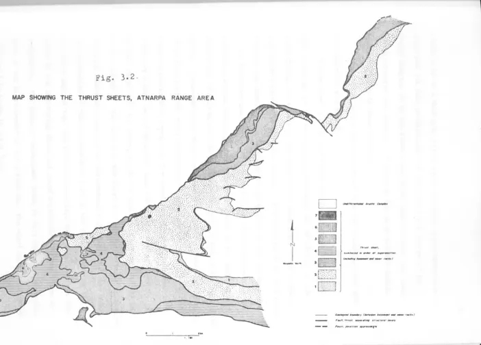
thrusts of about the same orientation give rise to an imbricate structure resulting in a pile of thrust sheets within the range as well as in the small area east of Atnarpa homestead. The thrust sheets or slices consist of either both the basement and the cover rocks or one of them. Fig. 3.2 shows seven such sheets which were mapped and in Map 2 the sheets are shown in structure sections, six of the sections drawn across the range and the seventh along it. The demarcation of the sheets on the northern limb of the Eastern Hill Range above sheet no.3 is somewhat arbitrary owing to the effects of metamorphism which obliterates the sedimentary features of the rocks. The structure of the Atnarpa Range area is further complicated as the thrusts are folded and their strike parallels at many places that of bedding or foliation.
[image:37.605.71.583.19.658.2]FIGUHE
3
.
2
Fig. 3.2
MAP SHOWING THE THRUST SHEETS, ATNARPA RANGE AREA
1
I
--J
c=J
c.-.~...,.~6
1I1ill
~ S~
·
EI
'C3
2
[2]
.
c:J
n,..., ""-'.
__ ..,..#/ .. .,.., " ___ ".vI . .
(. . . , . . . , . . , , _ ,..hl
&~~(~"_,,,,,_'_',J
[image:39.812.103.806.67.571.2]giving rise to a dark gray flinty crush rock with psuedotachylitic
veins and the near pulverization of the soft rocks either in the
Arunta Complex or in the cover rocks which look and feel like clay.
In the northern and northeastern parts of the range mylonitization
is associated with these contaQts?
Each thrust sheet and its contact with the overlying sheet are
now described separately.
Thrust sheet no.1 is restricted in its extent in the mapped
27
area so far as the cover rocks are concerned and is present on the
north facing and a part of the east facing escarpment of the Eastern
Hill Range adjacent to the Large Valley. The cover rocks in this sheet
comprise the basal, the middle and the lower part of the upper member
of the Heavitree Quartzite. At the contact of the quartzite with the
underlying Arunta Complex, the conglomeratic part of the basal member
is not well developed and the pebbles where present are only a centimetre
across. Cross bedding within the quartzite as well as its stratigraphic
order show that the rocks comprising it are right way up. The thrust
which separates this sheet from the overlying sheet No.2 appears to
originate either in the basement. near the basement-cover contact, or at that contact in the north, where the sheet no.1 tapers out (see Map
2, section EEl). The fact that the sheet no.1 starts building up towards
the south whereas along most of its contact with sheet nOo2 that sheet is represented by the conglomeratic part of the basal member of the
Heavitree implies that the rocks of sheet no.2 were detached from the
rocks of the underlying sheet and moved southwards over the plane of
detachment. The plane of detachment seems to have lain in the arkosic
part of the basal member of the quartzite. The sheet no.1 overlain by
Thrust sheet no.2 is of a 'large extent and is present along the
2
E.H.R. , along the eastern and northern borders of the Small Valley,
and in a small area in the northeastern protrusion of the western
Hill (see Fig. 3.2). The sheet comprises both the basement and
28
cover rocks but in Fig. 3.2 only the cover rocks have been delineated in it as the limit of this sheet in the basement rocks is indeterminable.
The unconformity between the basement and cover rocks within this sheet
is shown in Plate 3.9c, and the arkosic and conglomeratic beds of the basal member of the Heavitree Quartzite are generally present above it.
In the central part of the E.H.R. and including the eastern part of the Small Valley a complete section of the Heavitree Quartzite with a part
of the Lower Bitter Springs Formation overlying it is present in this sheet. (It has been stated in the earlier parts of this chapter that nowhere in the Atnarpa Range area a full section of the Bitter Springs
Formation is developed). Cross bedding in the middle member and ripple
marks in the upper member of the quartzite as well as the normal sequence
of units in the cover rocks prove that the stratigraphic order in them
is undisturbed in the E.H.R. In the other two areas of exposure of this
sheet the Bitter Springs formation and the upper member of the quartzite are partly present. It has not been possible to establish the nature
of stratigraphic order in these areas due either to poor exposure or lack of sedimentary structures. The only point worth mentioning in this
connection is the presence of the White Shale horizon overlying the
Bitter Springs Formation beds along the thrust contact of this sheet
with the sheet nOo3 in the area along the northern border of the Small
Valley. On the footwall of the thrust, which defines the contact of
2. Eastern Hill Range
,
,
29
this sheet with the overlying sheet no.3 or no.4, lie either the
White Soft Shales, being the topmost part of the quartzite sequence,
or another horizon of similar nature in the Bitter Springs Formation.
These horizons due to their incompetent and plastic nature facilitated
movement on the surface of the thrust. The hanging wall of the thrust
is either represented by the middle member of the quartzite in sheet
no.3 or by the Arunta Complex in sheet no.4. The thrust is folded
about the E.H.R. and plunges westward beneath the Small Valley. It
reappears due to reversal of the plunge on the northern side of the
Small Valley and partly on the northeastern slope of the Western Hill
as well as around a small tectonic window of thrust sheet no.2 in the
northeastern protrusion of Western Hill. Plate 3.3a shows this sheet
overlain by sheet no.3 and or sheet no.4 in the S~ 1 Valley and in
the northeastern part of the Western Hill. Plate 3.4a and plate
3.5a show this sheet overlain by sheet no.3 in the southern and northern
limbs of E.H.R. respectively. Map 2, cross sections CCt
to GGt show
the structural relationship of this sheet with the sheets nos. 3 and 4.
Thrust sheet no.3 is also of a large extent. It crops out in the
Small Valley in narrow bands along the thrust separating it from the
sheet no.2. It is also present on both the limbs of the E.H.R., along
the eastern border of the Western Hill, in the east-west hill range
south of the Small Valley, and in the northeastern part of the Western
Hill. The sheet comprises mostly the Heavitree Quartzite of which a
nearly complete section develops south of the Small Valley. Cross
bedding in the middle member of the quartzite (Plate 3.3c ), ripple
marks in the upper member of the quartzite (Plate 3. 1c ) and the normal
stratigraphic order of the units (Plate 3.1b) show that the cover rocks
in this sheet are also right way up. On the northern limb of the E.H.R.