University of Southern Queensland
Faculty of Engineering and Surveying
THE COMMERCIAL IMPLICATIONS OF THE
NZ SURVEYOR-GENERAL'S RULES FOR
CADASTRAL SURVEY 2008
A dissertation submitted by
Samuel Cech
in fulfilment of the requirements of
Courses ENG4111 and 4112 Research Project
towards the degree of
Bachelor of Spatial Science (Surveying)
University of Southern Queensland
Faculty of Engineering and Surveying
ENG4111 Research Project Part 1 &
ENG4112 Research Project Part 2
Limitations of Use
The Council of the University of Southern Queensland, its Faculty of Engineering and
Surveying, and the staff of the University of Southern Queensland, do not accept any
responsibility for the truth, accuracy or completeness of material contained within or
associated with this dissertation.
Persons using all or any part of this material do so at their own risk, and not at the risk of the
Council of the University of Southern Queensland, its Faculty of Engineering and Surveying
or the staff of the University of Southern Queensland.
This dissertation reports an educational exercise and has no purpose or validity beyond this
exercise. The sole purpose of the course "Project and Dissertation" is to contribute to the
overall education within the student’s chosen degree programme. This document, the
associated hardware, software, drawings, and other material set out in the associated
appendices should not be used for any other purpose: if they are so used, it is entirely at the
risk of the user.
Professor Frank Bullen
Dean
iii
Abstract
Deregulation is happening around the world, its aim is to promote market
competition and lower compliance costs while providing a secure business
environment. This dissertation examines New Zealand Government’s
justifications for deregulating cadastral surveying and the commercial implications
on the profession. Is anyone likely to benefit from the proposed changes? Will
compliance costs decrease? Are ownership rights protected? Will land trading
remain safe?
Research into the background of New Zealand legislation is presented in first
chapters followed by analysis of nineteen cadastral projects. These show that
lack of boundary monumentation and witness mark densities will increase
compliance costs.
The project also analyses costs that fall outside the example projects such as
social implications and costs to the profession especially with the introduction of a
new certification, which will result in the increase of public liability insurance for
licensed cadastral surveyors.
Future studies could be done to design appropriate rules for cadastral surveying
to ensure that there is a balance between maintaining the rights of property
holders to have accurate surveys while ensuring that survey costs and
Acknowledgements
I would like to thank my supervisors, Mr. Glenn Campbell and Mr. Shane
Simmons (USQ) for their support and guidance throughout my project.
I would also like to thank my project sponsors: Eliot Sinclair and Partners ltd. for
their financial support and advice and for providing the data and the software I
v
Table of Contents
LIMITATIONS OF USE... i
CERTIFICATION ...ii
ABSTRACT...iii
ACKNOWLEDGEMENTS...iv
TABLE OF CONTENTS... v
LIST OF FIGURES ...vii
LIST OF TABLES ...vii
GLOSSARY OF TERMS...viii
1 INTRODUCTION... 1
1.1 BACKGROUND... 2
1.2 PROBLEM... 3
1.3 PROJECT AIM... 5
1.4 STRUCTURE... 6
1.5 SUMMARY... 6
2 LITERATURE REVIEW... 7
2.1 INTRODUCTION... 7
2.2 THESTATUTORY FRAMEWORK... 7
2.2.1.1 The Surveyor-General's Rules for Cadastral Survey ... 9
2.2.2 Surveyor-General’s Rules for Cadastral Survey 2002/2 ... 9
2.2.2.1 Surveying professional bodies ... 10
2.2.3 The Proposed Changes ... 10
2.2.3.1 Cadastral Outcomes and Objectives ... 11
2.2.3.2 Rules of interest... 11
2.2.4 The Response to the Rules... 13
2.2.5 The Surveyor-General’s Interim Decisions ... 14
3 METHODOLOGY... 16
3.1 INTRODUCTION... 16
3.2 CURRENT VS. PROPOSED RULES... 16
3.2.1 Accuracy tolerances ... 16
3.2.2 Witness Mark Density - maximum allowable witnessing distances ... 18
3.2.3 Boundary Monumentation - marking of boundary corners ... 18
3.2.4 Redefinition Survey Plans ... 19
3.3 CONSIDERATION OF FACTORS... 19
3.3.1 Placement of survey and boundary marks ... 20
3.3.2 The criteria for use of a monumentation CSD ... 21
3.3.3 Best survey practice ... 22
3.3.4 Survey technologies including GNSS and Robotic Total Stations ... 22
3.3.5 Environmental factors... 23
3.4 RELATIONSHIP OF COSTS AND ACTIVITIES... 24
3.5 CONCLUSION... 25
4.1 INTRODUCTION... 26
4.2 COLLECTED DATA... 26
4.3 ANALYSIS... 28
4.3.1 Project Size breakdown... 31
4.3.2 Accuracy Tolerances... 34
4.4 PRELIMINARY RESULTS... 35
4.4.1 The effect on land usability ... 36
4.4.1.1 Revised methodology... 36
4.4.1.2 Assumptions... 37
4.4.2 Revised Results per Project Size ... 39
4.4.3 Revised Results... 42
4.5 FINAL RESULTS... 44
5 DISCUSSION AND CONCLUSION ... 45
5.1 SUMMARY... 45
5.2 COMMERCIAL IMPLICATIONS CONCLUSION... 45
5.2.1 Cost Results... 45
5.2.2 Society Implications ... 46
5.2.3 Implications on cadastral profession ... 46
5.3 ACHIEVEMENT OF AIMS AND OBJECTIVES... 47
5.4 POSSIBLE IMPROVEMENTS... 47
5.5 LIMITATIONS... 48
5.6 FUTURE WORK... 48
BIBLIOGRAPHY ... 49
APPENDIX A – PROJECT SPECIFICATION... 1
APPENDIX B – CADASTRAL OUTCOMES AND OBJECTIVES... 2
vii
List of Figures
FIGURE 1 – LINZ, CADASTRAL OUTCOMES AND OBJECTIVES 4
FIGURE 2 – ACCURACYTOLERANCES (ALL SHOWN IN METERS) 17
FIGURE 3 - PER ACTIVITY AVERAGE COSTS AS PERCENTAGE OF THE TOTAL COST 26
FIGURE 4 - ACTIVITY COSTS PER PROJECT 27
FIGURE 5 - EXAMPLE TITLE PLAN 28
FIGURE 6 - REQUIRED CONTROL AND BOUNDARY MARKS 29
FIGURE 7 - COST REDUCTIONS PER PLAN 30
FIGURE 8 - LARGE PROJECTS SAVINGS 31
FIGURE 9 - MEDIUM PROJECTS SAVINGS 32
FIGURE 10 - SMALL PROJECTS SAVINGS 33
FIGURE 11 – PRELIMINARY RESULTS – COST SAVINGS 35
FIGURE 12 - PLAN 15-16 IDENTIFICATION SURVEYS 37
FIGURE 13 - IDENTIFICATION SURVEYS RESULTS 38
FIGURE 14 - LARGE PROJECTS RESULTS 39
FIGURE 15 - MEDIUM PROJECTS RESULTS 40
FIGURE 16 - SMALL PROJECTS RESULTS 41
FIGURE 17 - COSTS VS. SAVINGS 42
FIGURE 18 – PRELIMINARY RESULTS – COST SAVINGS 43
FIGURE 19 – FINAL COST IMPLICATIONS 44
List of Tables
TABLE 1 – WITNESSING DISTANCES (METERS) 18
Glossary of Terms
GNSS Global Navigation Satellite System
sd standard deviation
LOL or LandonLine Landonline is the online service for surveyors, lawyers and other land professionals, providing
access to New Zealand's only authoritative
database for land title and survey information. It
enables land professionals to search, and to lodge
title dealings and survey data digitally.
LINZ or Land Information New Zealand
Land Information New Zealand (LINZ) is a New
Zealand government department responsible for
land titles, geodetic and cadastral survey systems,
topographic information, hydrographic information,
managing Crown property and a variety of other
functions.
ESP or Eliot Sinclair and Partners Ltd
Eliot Sinclair & Partners Ltd provides services to a
wide range of businesses in many sectors including
land development, building and construction, local
government services, utilities and port authorities
C h a p t e r
1 INTRODUCTION
Land Information New Zealand (LINZ) is responsible for providing land related
services such as titles registry and the development of policies and regulations to
ensure certainty of land property rights within the social and economic systems of
New Zealand.
Since the late 19th century New Zealand adopted the Torrens system of land
transfer and registration. The backbone of this system is survey accurate
geographic information (the cadastre) that enables landowners to identify property
related interests. Fast access to accurate cadastral information is an important
part of New Zealand economic growth.
New Zealand like many other jurisdictions transformed a paper-based system by
implementing an electronic system for land registration, survey lodgement and
transaction dealings in land rights. Some parts of New Zealand
Surveyor-General’s Rules for Cadastral Survey 2002/2 (the current Rules) have become
irrelevant and confusing (LINZ, 2007) due to the changes that occurred in the past
6 years. These changes include the introduction of LandonLine digital cadastre in
2002/3, requirements for 100% electronic lodgement of survey datasets in
September 2007 and 100% electronic lodgement of all legal transactions by the
end of 2008.
To address the irregularity of this legislation a new set of rules was proposed by
the government, the New Zealand Surveyor-General’s Rules for Cadastral Survey
1.1 Background
There are two levels of regulatory intervention for cadastral surveying in New
Zealand. The principal regulation is the Cadastral Survey Act 2002 (the Act) and
the secondary regulation is the Surveyor-General’s Rules for Cadastral Surveys
2002/2 (the current Rules). The focus of this research is the changes to the
current Rules and their impact. There are no changes proposed to the Act, which
outlines responsibilities of the Government, licensed cadastral surveyors and
provides for the setting of standards for cadastral survey datasets and national
geodetic and control systems. The current Rules describe in detail the
methodology, techniques and standards for cadastral datasets.
While the cadastral regulation was aimed at facilitating digital lodgement of
cadastral datasets it is largely focused on an older type of technology and fails to
be flexible towards advancements in survey equipment and techniques (LINZ,
2007). Some rules are concerned with data presentation and symbology that
were relevant when the paper based cadastral plans were used and is now the
responsibility of the Government to provide standards and functionality within the
LandonLine system.
The Government proposed to reduce regulatory intervention as per their ‘Optimal
Regulation’ policy (Surveyor-General, 2006). This policy is mainly focused on
“what” is important within the cadastre not “how” to achieve it. It is believed to be
in the best interest of the public to deregulate cadastral surveying and let the
market forces dictate “how” surveyors use new techniques and methodologies to
The need for this project arose from the lack of evidence provided by the
Government that their proposed regulatory change would result in economic
benefit to the country. Considering the history of failed deregulated industries
such as the Electricity and Railway networks that had to be re-regulated
(Business New Zealand, 2006) it is important to research the implications of major
regulatory changes.
1.2 Problem
A regulatory analysis framework was developed by LINZ to identify the critical
outcomes and objectives (Surveyor-General, 2006) see
Figure 1. There are four steps within this framework as defined by LINZ
(Surveyor-General, 2006).
1. Identify the purpose of the cadastre by defining outcomes, objectives and
sub-objectives.
2. Identify risks of not achieving these outcomes and objectives.
3. Determine the level of intervention required i.e. regulation or guidelines
or education or no intervention.
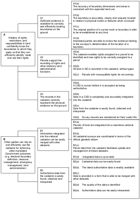
Figure 1 – LINZ, Cadastral Outcomes and Objectives
A1(a)
The accuracy of boundary dimensions and areas is consistent with the expected land use
A1(b)
The boundary is accurately, clearly and uniquely located in relation to physical marks or features when surveyed A1(c)
The original position of a survey mark or boundary is able to be re-established at any time
A1(d)
Interested parties are able to review the evidence relating to the surveyor’s determination of the location of a boundary
A2(a)
The cadastre enables rights assigned to a parcel to be identified and new rights to be correctly assigned to a parcel
A2(b)
All land in NZ is recorded in the cadastre, without gaps A2(c) Parcels with incompatible rights do not overlap
A3(a)
A CSD is correct before it is accepted as being authoritative
A3(b)
Data in a CSD is completely and accurately integrated into the cadastre
A3(c)
Data from the cadastre is easily found, obtained and interpreted
A3(d) Survey records are maintained for their useful life B1(a)
Parcels of land are integrated into a seamless national cadastre
B1(b)
All cadastral surveys are coordinated in terms of the official geodetic datum
B1(c)
Parcel data from the cadastre facilitates update and management of linked datasets.
B1(d) Integrated data is up-to-date B2(a) Cadastral data can be easily found
B2(b) The latest authoritative data is readily available B2(c)
Data is provided in a form that is able to be merged with other datasets
B2(d) The quality of the data is identified B2(e) Authoritative data can be easily interpreted
B
Other parties can rely on and efficiently use the cadastre for achieving
other mandated Government outcomes (e.g. electoral boundary definition, resource management, emergency management, land administration) B1 Information integrated into the national cadastre can be easily merged with other datasets
B2 Authoritative data from the cadastre is easily found, obtained and interpreted
A
Holders of rights, restrictions, and responsibilities in land
confidently know the boundaries to which they
apply so that they can efficiently identify, trade
and use their rights
A1 Sufficient evidence is available for correctly and efficiently locating boundaries on the ground
A2 Parcels support the recording of rights and other statutory land administration functions
Completeness of this list directly affects the purpose of the cadastre and
achievability of the main outcomes. Any errors in the risk assessment analysis
will result in failure to correctly identify risks and design objectives and outcomes
to mitigate such risk. Therefore it forms a part of this project to identify any rules
missing or unnecessary in order to achieve the outcomes and objectives and to
analyse what commercial implications of economic benefit or otherwise it may
cause.
Two main outcomes are (LINZ, 2007):
A. Holders of rights, restrictions, and responsibilities in land confidently
know the boundaries to which they apply so that they can efficiently
identify, trade and use their rights.
B. Other parties can rely on and efficiently use the cadastre for achieving
other mandated Government outcomes (e.g. electoral boundary
definition, resource management, emergency management, land
administration).
1.3 Project Aim
The aim of this project is to investigate the commercial implications that may arise
should the proposed Rules be implemented by Land Information New Zealand in
1.4 Structure
This chapter is an introduction into the background need, aim, problem and
specific objectives of this research. The following chapters deliver information
about literature, methodologies and analysis together with conclusions about the
commercial implications of the proposed Rules.
1.5 Summary
The commercial implications could include reductions in compliance cost,
changes to the costs of undertaking cadastral surveys and changes to
commercial insurance cost. In addition implications on society could include a
decrease in the public’s trust in the cadastral system, which could impact on the
integrity of the land titles system that has been in place for the past 150 years.
The proposed Rules were developed to address the Government’s policy of
‘Optimal Regulation’. This policy aims at decreasing bureaucracy and compliance
costs and maximising the potential of the marketplace (LINZ, 2007). With this
draft the Surveyor-General is promoting self-regulation of the survey profession.
This project will answer the question if this can be achieved.
It is also important to analyse the completeness of the proposed Rules to ensure
the interests of landowners and holders of land rights, the community, the survey
C H A P T E R
2 LITERATURE REVIEW
2.1 Introduction
The aim of this dissertation is to establish whether there would be any commercial
implications by the proposed Rules for Cadastral Survey 2008. This chapter
presents a summary of the literature and statutory documentation that was
reviewed before undertaking the cost analysis of projects under the current and
the proposed Rules.
The chapter starts by giving a brief description of the statutory framework that
forms the foundation of the surveying profession in New Zealand and the current
statutory position. It then presents a discussion of the proposed changes and a
brief summary of the reaction by the profession. The chapter concludes if any
literature could support the claim by the Government that deregulation and the
introduction of the proposed Rules will lead to a decrease in compliance costs
and a maximisation of the potential of the market place. LINZ did not publish the
proposed Rules with any supporting research or study, nor has there been any
such literature made available since the introduction of the proposed Rules.
2.2 The Statutory Framework
Land Information New Zealand administers the survey system primarily to provide
maintains cadastral survey records for all tenure systems, including freehold and
leasehold (Land Transfer Act 1952), MƗori land and Crown land.
LINZ's functions and responsibilities in relation to the New Zealand's survey
system are set out in the Cadastral Survey Act 2002.
The Surveyor-General is part of LINZ's Regulatory Group. A function of the
Survey-General is to set standards for the cadastral and geodetic survey systems,
and monitors and audits compliance with the standards. Under section 49(1) of
the Cadastral Survey Act 2002 the Surveyor-General may make rules about the
conduct of cadastral surveys including the use of survey marks and standards for
cadastral survey datasets and section 49(3) states that the Surveyor-General
must have regard to the following matters:
a) the extent to which the proposed standards will promote the purpose
of any tenure system:
b) the costs and benefits of consistency in standards relating to more
than 1 tenure system:
c) the costs and benefits of maintaining the accuracy of the cadastre:
d) the costs involved in cadastral surveys and cadastral survey datasets
complying with the proposed standards:
e) maintaining public confidence in the cadastre.
The Cadastral Survey Act 2002 is the backbone of the statutory framework that
administers the surveying profession. It is the enabling act for the various rules
and regulations that make the profession work. This Act sets out the basic rules
2.2.1.1 The Surveyor-General's Rules for Cadastral Survey
The Surveyor-General's Rules for Cadastral Survey were made under authority of
the Cadastral Survey Act 2002. These rules determine how the spatial extent
(including boundaries) of interests in a tenure system are defined and described.
The current Rules are set out in the Surveyor-General's Rules for Cadastral
Survey 2002/2, which came into effect 29 October 2002.
Version 2002/2 is now being reviewed and is the catalyst for this dissertation.
2.2.2 Surveyor-General’s Rules for Cadastral Survey 2002/2
The main purpose of Version 2002/2 was to make provision for digital lodgement
of cadastral survey datasets (CSD) into LandonLine (LOL), enabling electronic
transactions and electronic plan production (LINZ, 2007). According to Grand
(2006) these rules failed to deliver flexibility for use of future technologies and
methods. Based on the 1998 regulations these rules focus on traditional survey
equipment and techniques leaving little room for implementation of new
technologies such as GNSS using virtual reference station.
Since the introduction of compulsory electronic lodgement via LOL eSurvey some
of the 2002 rules became irrelevant. The LOL electronic lodgement means all
surveys are processed electronically via a secured Internet connection using
LandonLine website (eSurvey software). This system relies on observed vector
data, bearings and distances, which are adjusted and incorporated into the
national network. Survey plans and parcel diagrams are also produced
traverse calculations are necessary. This removes the need for large number of
rules relating to conventional hard copy lodgement.
The above are the two main reasons for changing the regulation. The
Government is also trying to empower the profession by lowering government
intervention and would like to see the profession take responsibility through
self-regulation and producing its own best practice guidelines (Surveyor-General,
2006). The aim is to lower compliance costs and maximise the potential of the
market place.
2.2.2.1 Surveying professional bodies
In New Zealand there are two organisations involved in cadastral surveying, the
New Zealand Institute of Surveyors and the Institute of Cadastral Surveying.
Institutes monitor professional and ethical conduct of their members. However,
membership to these institutes is voluntary. Surveyors licensed by the Cadastral
Surveyors Licensing Board (the Board) are not required to be members of a
professional body. The Board is only concerned with setting standards,
disciplining and issuing licenses to carry out cadastral surveys. Self-regulation by
the cadastral survey profession would be hard to achieve without compulsory
membership within a single professional body.
2.2.3 The Proposed Changes
The proposed Rules were designed to satisfy the Government’s Optimal
Regulation policy. Their aim is to promote minimal government intervention,
lowering compliance costs and increasing the potential of the marketplace (LINZ,
End Outcomes necessary to satisfy requirements under the Cadastral Survey Act
2002 and protecting public interests within the cadastral system.
The proposed Rules are aimed to assist and instruct cadastral surveyors when
carrying out cadastral surveys and lodging documentation with LINZ.
2.2.3.1 Cadastral Outcomes and Objectives
The two End Outcomes relate to the use, trade and identification of boundaries of
rights and restrictions by affected parties and the use of cadastral information by
other parties. It is therefore important to compare the proposed Rules to the table
of objectives and outcomes and analyse if these can be achieved and will they
result in desired economic benefits.
This research is focused on the end outcome A in particular intermediate outcome
A1 and its objectives and sub-objectives. For the complete table of the End
Outcomes and Objectives see Appendix B.
2.2.3.2 Rules of interest
The rules that are most likely to have commercial implications relate to accuracy
tolerances, placement of survey and boundary marks, documentation and
certification compliance.
It is reasonable to assume that licensed cadastral surveyors will employ methods
and technologies based on the accuracy standards required. Relaxed accuracy
tolerances could have cost saving benefits for the surveyor and may be passed
on to clients and rights holders. Accuracy tolerances are specified within Rule 2.
positional accuracy between a witness and a boundary mark as well as the
positional accuracy between two boundary marks and area accuracy of parcels.
Rule 2.3 is set out in full in Appendix C.
Placement of a survey or a boundary mark requires fieldwork that utilises multiple
staff and equipment. Reduction of number of marks placed during a survey
should have a direct cost saving benefit for the client or first registered proprietor
(Rule 6). However, long-term effects could include boundary disputes where right
holders are unable to identify their boundaries or increases of cost to subsequent
surveys due to lack of old survey marks being detrimental to hierarchy of
evidence for location boundaries.
Rule 6 would make it difficult to achieve Sub-Objective A1(a)5, which states that
the accuracy of boundary dimensions is able to be increased as land use
intensifies. The concepts of accurate boundary dimensions on the one hand and
removing the necessity of survey marks are difficult to reconcile. The higher the
land use intensities the greater the importance of maintaining boundary accuracy
by retaining the practice of ‘from whole to part’ and mandatory placement of
survey marks.
The rules also widen the certification required by surveyors. Rule 12 requires
licensed surveyors to undertake that a survey has been carried out not only in
accordance with the Cadastral Survey Act 2002 and subordinate legislation such
as the proposed Rules but also all other relevant enactments and rules of law
(LINZ, 2008). This wording could increase the liability of cadastral surveyors in
tort and common law and increase the costs of cadastral survey should surveyors
jurisdiction of this act beyond its intended purpose. No evidence could be found
during this project to suggest that similar certifications are in use in New Zealand
or Australia. It is possible that courts would have to decide on the enforceability
and practicality of this rule.
2.2.4 The Response to the Rules
The profession responded by lodging submissions, many of which expressed
concerns regarding the impact that the proposed Rules would have on the
profession (LINZ, 2008).
Of significance are the following issues:
o Boundary Marking
Submissions highlighted that the relaxed monumentation requirements may
not achieve the intermediate outcome A1 and significantly affecting the
hierarchy of evidence for locating boundaries.
o Accuracy Tolerances
Many of the submissions agreed that relaxing accuracy standards to the
proposed level would have serious effects on the cadastre network, boundary
definition and title area with some expressing concern in respect to the
possible negative effect on public trust in the cadastre.
o Witnessing of boundary points
There were both support and opposition to the proposed changes to the
witnessing distances of boundary points. It has to be noted that increasing
witnessing distances could result in decrease of survey witness mark density
o Certification
One third of the submissions opposed the changes to the certification by
licensed cadastral surveyors (LINZ, 2008). As set out above the changes
would require a certification that the CSD and survey were in accordance with
all other enactments and rules of law. Submitters raised questions about the
validity of such certification and possible market implications of increased
insurance costs and legal liability of licensed surveyors.
o General comments
The response from the profession and the general public highlights the public
interest in this issue. LINZ received submissions from 16 individuals and 42
groups including survey and legal professionals, groups of surveyors
associated with the survey professional bodies, local government, the
University of Otago and survey supply firms (LINZ, 2008(3)). All submissions
show a great interest and some offer solutions to the issues presented by the
proposed Rules.
2.2.5 The Surveyor-General’s Interim Decisions
According to the process of public consultation the Surveyor-General and an
expert committee reviewed the submissions. Thereafter, all submitters were
given the interim decision made on parts of the Rules deemed ‘matters of greatest
concern to the submitters’ (LINZ, 2008(2)) including Boundary marking, Boundary
marks, Accuracy tolerances, Water boundary accuracy, Area accuracy,
Orientation, Geodetic connection, Witness mark and permanent reference marks,
These decisions are general statements of intent as exact wording of the rules is
not yet available. In general, these address the greatest concerns of accuracy
and reliability of the cadastre. Decisions made by the expert committee will have
an effect on the commercial implications of these Rules. As such these will be
C H A P T E R
3
METHODOLOGY
3.1 Introduction
This chapter describes methods used to analyse selected cadastral survey
datasets. Firstly presenting a comparison of the major changes to the Rules and
defining factors for the analyses of data. Followed by secondary or consequential
factors that maintain a realistic nature for the analyses. Finally providing a
comparison between selected datasets and their changes in accordance with the
proposed Rules and the factors described in this chapter.
3.2 Current vs. Proposed Rules
Primary changes that may affect the cost of cadastral surveys are:
a) Accuracy Tolerances
b) Witness Mark Density - maximum allowable witnessing distance
c) Boundary Monumentation - marking of boundary corners
d) Redefinition Survey Plans
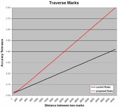
3.2.1 Accuracy tolerances
Relaxing accuracy tolerances should decrease compliance costs allowing the
profession to choose the most appropriate methodology and increase productivity.
The level of accuracy must achieve the cadastral objective A that Holders of
rights, restrictions, and responsibilities in land confidently know the boundaries to
(LINZ, 2007). The proposed root sum square standard is
0
.
03
2D
u
0
.
0002
2in meters or 1 meter where D is the distance between the points in metres. The
comparison to the current standard of 0.02 meters plus 0.01 meters per 100
[image:26.595.128.532.208.576.2]meters of distance between the points is shown in Figure 2 below.
Figure 2 – Accuracy Tolerances (all shown in meters)
The purpose of these rules is to allow flexibility of technology and techniques
when conducting a cadastral survey. The above accuracy tolerances aim to
accommodate this and fail to safeguard boundary accuracy. LINZ only analysed
the effects of this rule for the first 200 meters (LINZ, 2007) of distance in which
achievable by GNSS or such that can be expected from future technologies. The
argument presented by LINZ in justification for decreased accuracy is that GNSS
is less accurate over shorter distance but more accurate over long distances
(LINZ, 2007). The Figure 2 above clearly shows the proposed new accuracy
standard only accommodates use of GNSS for the shorter distances. At four
kilometres the accuracy tolerance is almost double the present standard despite
GNSS being more accurate at and above this distance. This is an unnecessary
lowering of accuracy with inadequate justification.
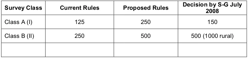
3.2.2 Witness Mark Density - maximum allowable witnessing distances
Changes to this rule may have a direct impact on the number of survey marks
used during a cadastral survey and time required to connect or establish these
marks. Long-term effects could include changes to witness mark densities and
cost implications for future surveys where lack of existing marks may require
extensive fieldwork when connecting to the available marks. The following table
shows the comparison between the current and the proposed Rules witnessing
[image:27.595.117.531.532.630.2]distance.
Table 1 – Witnessing Distances (meters)
Survey Class Current Rules Proposed Rules Decision by S-G July 2008
Class A (I) 125 250 150
Class B (II) 250 500 500 (1000 rural)
3.2.3 Boundary Monumentation - marking of boundary corners
It is a compulsory requirement of the current Rules to mark all boundary
corners/positions where practical. The proposed Rules only require placing
owners request them. Monumentation of boundary corners adds to the hierarchy
of evidence for locating rights associated with land. Monumentation is the
backbone of New Zealand cadastre minimising boundary disputes.
Surveyor-General in his interim decision stated that boundary monumentation would be
required in the final document. Monumentation along long boundary lines may no
longer be required under the proposed Rules.
3.2.4 Redefinition Survey Plans
The current Rules define Redefinition survey as:
a survey undertaken for the purpose only of reinstating 1 or more parcel
boundaries. (LINZ, 2002)
The information required to be lodged under the current Rules include all
observations and measurements as per any other survey purpose. The proposed
Rules reduce the documentation requirement to that of boundary mark types and
names where no observation data is required or necessary. The licensed
surveyor is solely responsible for the accuracy and placement of these marks
when certifying lodgement of a monumentation dataset. This rule is designed to
decrease the cost of completing redefinition surveys where no new allotments are
created.
3.3 Consideration of factors
Information collated for this project was made available by Eliot Sinclair and
Partners Ltd (ESP) of Christchurch, New Zealand. Survey datasets represent
sample of cadastral plans completed and lodged by ESP between 2003 and 2008
Analysed data is presented as time and cost shown as hours and percentages
representing increase or decrease of cost.
Many aspects are present in professional practice and have an impact on budgets
of cadastral projects. The scenario for testing commercial implications of changes
to regulation must take into account all those factors that arise from the regulatory
change and consequent factors or secondary factors. Traverse or pegging
distances for example may only be as long as the environment allows and not
necessarily take advantage of any increase in allowable distances. Survey
technologies and equipment in use today may allow for more unconventional
approach increasing productivity and accuracy.
Consideration must also be given to the total cost of the cadastral project to
demonstrate the significance of any compliance cost savings as advertised by the
government.
3.3.1 Placement of survey and boundary marks
Every boundary point defined or marked during a cadastral survey must be
witnessed by a survey mark within a specified horizontal distance. Prior to the
current Rules this was a directly measured line with a theodolite between the
boundary mark and its witness. These lines are referred to as pegging ties. The
2002 regulation no longer requires for a witness mark to be directly connected to
the boundary point it witnessed. This is primarily to enable new technologies
such as GNSS to be used for cadastral surveys. Witnessing distance is now
described "as the crow flies" (LINZ, 2006) with focus on stability and performance
rather than convenience or compliance. This approach has its disadvantages as
Rules increased this witnessing distance from 125 metres to 200 meters. This
was strongly opposed by the profession when LINZ received submissions that
rule 6.3 should be reworded and witnessing distance decreased. The primary
concern being lack of witness marks used during a cadastral survey could have a
detrimental effect on the future of cadastral surveying effecting survey mark
density in the national network and hierarchy of evidence for reinstatement of
boundary positions. Surveyor-General made a decision to decrease witnessing
distances to 150 metres with exemptions for rural surveys where witnessing
distance will be increased to 1000 metres. This is to provide for adequate but not
unreasonable density of witness marks (LINZ, 2008(2)). Commercial implications
arising from decreased density of witness marks will include increased costs of
locating existing marks and cost savings where lower number of new witness
marks is required for example during a rural surveys.
To assess the commercial implications of the above factor each test survey will be
analysed to determine if any number of witness marks or control stations could be
omitted from the survey. Total time of the fieldwork is divided between all station
as per the equipment used and number of survey and boundary marks placed.
3.3.2 The criteria for use of a monumentation CSD
LINZ (2007) note that in spite of the current regulation requirements for lodgement
of redefinition datasets many surveyors do not submit any information when
marking an existing boundary. The monumentation CSD is proposed to replace
the current redefinition survey plans where no new parcels are created. This type
of dataset must include information about old witness marks, boundary marks and
new boundary marks placed in position of previously approved boundary
diagram showing boundary marks placed, parcel identifiers for adjoining parcels
and witness marks found and used to witness each new mark. There is no
requirement for dimensions to be shown as the Licensed Cadastral surveyor must
certify that survey complies with all relevant rules. This should result in lower
compliance costs for redefinition surveys.
3.3.3 Best survey practice
Analyses of test survey datasets have to consider best survey practices
recommended by the Surveyor-General and LINZ. Until 2004 LINZ maintained
Cadastral Survey Guidelines document describing the best survey practice and
their interpretation of the Cadastral Survey Rules. It is now expected that the
survey profession will develop the best survey practice guidelines as part of
self-regulation. For the purpose of this research design of survey geometry follows
the Cadastral Survey Guidelines 2004:
placing marks where they are not like to be disturbed,
easily accessible creating strong geometric shapes and avoiding hanging
vectors,
sufficient number of old marks must be located or other evidence such
that supports definition of the parcel being subdivided.
3.3.4 Survey technologies including GNSS and Robotic Total Stations
New technologies available to cadastral surveyors can be utilised to increase
productivity and accuracy. It is one of LINZ’ reasons for changing the regulation
to enable wider use of modern digital equipment such as GNSS and Robotic Total
Stations. The use of this equipment makes traditional field note recording of
cadastral surveys impossible. Surveyors will have to develop new techniques for
techniques from other survey disciplines can be modified to suit cadastral
surveying with attention to appropriate use of new technologies that make it
possible to reinstate boundary points in the future. Intervisibility between marks is
an important issue and while one surveyor has access to GNSS another may not.
According to LINZ (2007) the completion of a redefinition survey or the proposed
monumentation CSD should be inexpensive task and surveyors are required to
provide under the proposed Rules reasonable hierarchy of evidence for boundary
monuments. As part of the following analysis no marks will be placed in a
position where it would be considered unreasonable and or not intervisible with at
least one other mark in that survey.
3.3.5 Environmental factors
While the environment is identical for both surveys under the current and
proposed Rules it may have a different effect on traditional and new technologies.
Where the use of a theodolite or a total station is dependant on line of sight GNSS
equipment does not but the effect of dense vegetation is much greater on GNSS.
To ascertain such effects aerial photographs were used to determine what
equipment would be most efficient given the environmental factors. This may
result in the use of the same conventional equipment or warrant introduction of
modern equipment. Analyses of the absolute extreme case without consideration
of the environment would provide unrealistic results where placing of marks could
be impossible or impractical. Site-specific obstructions such as buildings, trees
and dense vegetation must be considered when estimating number of control
3.4 Relationship of costs and activities
Cadastral projects encompass many activities not all of which are under the
jurisdiction of Cadastral Survey Act 2002. The total cost of a cadastral project
may include sourcing subdivision or resource consent, administrative costs, travel
to the site and meetings and discussions with client not all of which will change
due to the new regulation. Some costs are fixed or unrelated to the physical part
of cadastral surveying. Therefore, these activities were identified and excluded
from the analyses. Time records for each test surveys were divided into five
categories:
a) Fixed costs – such as administrative costs and obtaining of consents,
instruction, discussion and correspondence.
b) Travel costs – this is most likely to be fixed cost for smaller jobs as
any reduction in field work is not likely to be as long as a day field trip,
however, on larger projects this could be significant.
c) Office calculation costs – the amount of time necessary to prepare
definition calculations, field reductions and adjustments is relative to
the complexity and size of the survey and fieldwork. Changes of the
time for fieldwork will be proportioned into office calculations.
d) Field work costs –field work time will be allocated to control station
depending on used equipment and number of boundary marks placed
from each station, cost of the survey can be estimated based on
number of control marks necessary to complete that survey according
to the proposed Rules.
e) Drafting – time required for drafting of survey plans is relative to the
complexity and geometry of the survey and number of extra diagram
sheets used. This can be related to the number of control stations
The above categories will be analysed individually and results collated into a
single spreadsheet showing total job cost comparison and individual categories.
3.5 Conclusion
This chapter described the approach to the analyses. While each test survey is
different in its nature results should be comparable as percentages of the total
cost of each job. The use of an electronic spreadsheet to produce tables and
graphs of the results will support the final conclusion of what commercial
C H A P T E R
4 ANALYSIS AND RESULTS
4.1 Introduction
This chapter analyses and presents results for nineteen cadastral surveys
selected for this study of commercial implications. Data was sourced from ESP’s
accounting software package AccPack and cadastral records. This data was
used to estimate financial saving for test surveys. The results show a general
trend in decrease of costs.
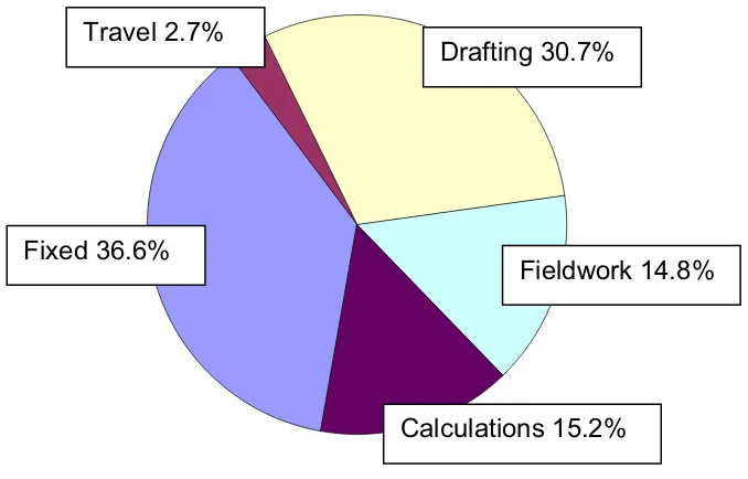
4.2 Collected Data
The financial data about each project was divided into categories according to the
activity that took place. The five categories include fixed costs, travel costs, office
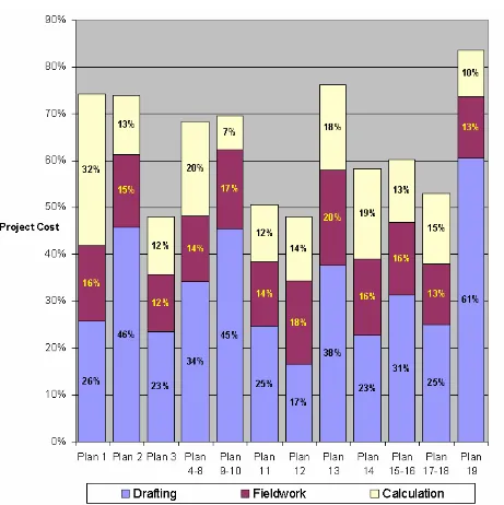
[image:35.595.155.494.468.685.2]calculations, fieldwork and drafting. These are shown in the following chart:
Figure 3 - Per activity average costs as percentage of the total cost Fixed 36.6%
Travel 2.7%
Drafting 30.7%
Fieldwork 14.8%
Only three of the above categories have a potential for savings. This is due to the
fact that the fixed costs are considered to be constant in regard to the proposed
regulatory changes. The Figure 3 above shows that the travel costs are smallest
of all costs and any reduction in travel costs can be considered insignificant.
Therefore, this study concentrates only on Calculation, Drafting and Fieldwork
costs. Following Figure 4 shows cost distributions per each one of the plans
[image:36.595.82.543.243.705.2]studied.
4.3 Analysis
Three major changes were selected for this analysis.
x boundary monumentation,
x witness mark density and
x accuracy tolerances.
As discussed in the previous chapter boundary corners must be monumented
only if in dispute with the cadastre. To test for the maximum benefit it is assumed
that the owner will not require any extra monuments to be placed. This assumes
the best-case scenario in terms of the cost benefit on the project. Relaxation of
the witness mark density in the Proposed Rules was used to identify minimum
required number of marks for each test plan. Each plan was analysed individually
and time/cost was allocated to monumentation tasks based on the ESP records.
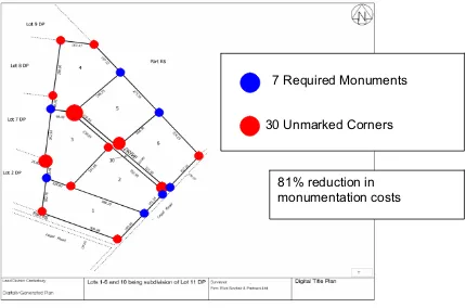
[image:37.595.125.555.427.711.2]Following example plan shows monuments not required resulting in savings.
Figure 5 - Example Title plan
7 Required Monuments
30 Unmarked Corners
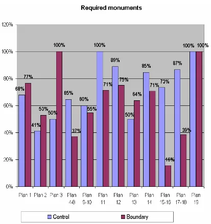
Figure 6 - Required Control and Boundary Marks
The figure above shows percentages of control and boundary marks required
under the proposed Rules for each of the test plans. The average reduction of
control marks is 70% with a standard deviation of 20% and the average reduction
of boundary marks is 63% with a standard deviation of 25%. The cost of
establishing control marks and boundary marks is estimated based on the ESP
time records to be two to one respectively. The following figure shows amount of
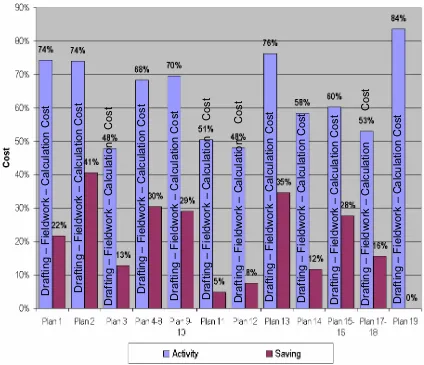
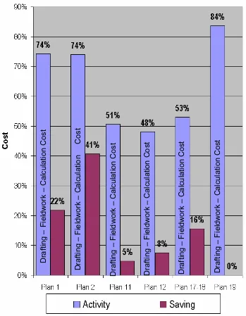
Figure 7 - Cost reductions per plan
The average cost reduction is 20% with a standard deviation of 13%. The
minimum saving is 0% and maximum saving is 41% of the original project cost.
4.3.1 Project Size breakdown
The above Figure 7 can be reorganized in terms of the project size to analyse if
this has an effect on the average cost reductions. Following figure shows cost
reductions for large size projects costing over $100,000:
Figure 8 - Large Projects savings
The average cost reduction for eight large size projects tested is 24% with a
standard deviation of 9% of the total project cost. Following figure shows cost
reductions for medium size projects costing over $40,000:
Figure 9 - Medium Projects savings
The average cost reduction for four medium size projects tested is 25% with a
standard deviation of 12% of the total project cost. Following figure shows cost
reductions for small size projects costing less than $40,000:
Figure 10 - Small Projects savings
The average cost reduction for seven small size projects tested is 15% with a
standard deviation of 15% of the total project cost.
[image:42.595.147.496.71.520.2]4.3.2 Accuracy Tolerances
From discussions with licensed surveyors at ESP it can be assumed that the
relaxation of accuracy tolerances by the proposed Rules may have an effect on
the cost of cadastral projects. However, this cost is difficult to estimate. There is
a potential for decrease of costs while placing monuments in the field and also
potential for increase in costs when locating old marks or proving reliability of old
monuments. Using correct field techniques should result in every survey being
compliant with the proposed Rules accuracy tolerances. LINZ (2008) noted that
this part of the proposed Rules will be rewarded and accuracy tolerances will be
similar to those of the current Rules. Therefore, it is assumed there will be no
4.4 Preliminary Results
Figure 11 – Preliminary Results – cost savings
The results presented in the figure above indicate that the cost of most projects
would decrease. Some projects may not benefit from any cost reductions due to
their size. If the two highest and the two lowest results were considered to be
outliers and were removed and all these categories were combined the average
saving would be 21% with a standard deviation of 8%. This is a large amount
potentially welcomed by any land developer. However, the effect on the land
usability must be considered prior to any conclusion.
8 Plans 4 Plans 7 Plans
4.4.1 The effect on land usability
The product of a residential subdivision survey is an allotment that can be easily
identified, enjoyed and traded on the open market. The proposed Rules as
shown above will decrease the density of witness marks and boundary
monuments. Local Authorities under the Building (2004) and Local Government
(2002) Acts may require further surveys where there is insufficient evidence that
structures are being erected in the correct place. It is currently a common
condition of a building consent where owners must present evidence that the
framework is located correctly relative to the cadastral boundaries. Locating of
the physical evidence (boundary monuments) or an identification survey by a
Licensed Cadastral surveyor may be required as part of the evidence. Due to the
lack of witness and boundary monuments as a result of the proposed Rules it is
assumed that all future building consents will require identification surveys and
building location certificates to be issued resulting in increased cost of future
developments. The cost of these surveys is analysed below and will show that
initial savings are negated by the cost of future surveys. Appropriate methodology
and assumptions are discussed below followed by retesting of the datasets and
presenting adjusted cost benefit results.
4.4.1.1 Revised methodology
The following information is based on hypothesis derived from discussions with
Licensed Cadastral surveyors at ESP. The scenario tested assumes that Local
Authorities will require boundary identification surveys to be undertaken prior
allowing buildings to be erected. It is possible that identification surveys could be
required prior fencing by contractors limiting their public liability or by new
4.4.1.2 Assumptions
Identification surveys are usually completed at low cost or fixed cost to the client,
as the work involved is generally limited to locating old marks and proving
reliability of existing boundary monuments. The average cost of such survey is
around 8 hours including administration and travel costs. The original scenario
above considered absolute minimum of boundary monuments and witness marks
is place during a cadastral survey to achieve the highest possible cost savings.
This is repeated here with the assumption that placement of control and boundary
marks will be necessary in the future, as boundaries are not monumented during
the original survey as per the original scenario. To estimate the cost of cadastral
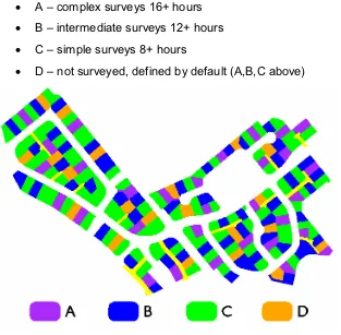
surveys Plan 15-16 was selected for analysis. This plan features over 200
allotments being representative of a large sample for identification surveys.
Allotments were divided into four categories representing level of complexity and
time necessary to complete their identification surveys. Those categories are:
x A – complex surveys 16+ hours
x B – intermediate surveys 12+ hours
x C – simple surveys 8+ hours
x D – not surveyed, defined by default (A,B,C above)
[image:46.595.171.484.429.736.2]Allotments allocated for each category are shown in Figure 12 above. Category A
comprises of approximately 10% of the lots, category B comprises of 10% and
category C comprises of 50% leaving 30% of allotments not needing to be defined
as they are enclosed by other defined allotments. Once these surveys are
completed this will result in the same level of boundary monumentation as that of
example Plan 15-16 enabling building developments to take place.
The above category proportions can be applied to all test projects. The cost of
identification surveys is adjusted for each projects hourly rate and presented as
percentage of the original cost of each project in the following Figure 13.
[image:47.595.153.495.327.669.2]4.4.2 Revised Results per Project Size
Reorganized data in terms of the project size is shown in the following figure.
Shows cost implications for large size projects costing over $100,000:
Figure 14 - Large Projects results
The above figure shows the initial savings, costs of monumentation survey and
overall balance/cost implication on the project. The cost implication is a cost
increase of 19% with a standard deviation of 7% of the total project cost.
Following figure shows cost implications for medium size projects costing over
Figure 15 - Medium Projects results
The above figure shows the initial savings, costs of monumentation survey and
overall balance/cost implication on the project. The cost implication is a cost
increase of 7% with a standard deviation of 30% of the total project cost. The cost
increase for Plan 13 was much smaller than the savings. This is likely due to the
secondary purpose of that plan, which had to deal with a balanced parcel with
Limited as to Parcels definition requiring extra fieldwork. Since this is the only
plan showing cost decrease it could be considered to be an outlier for the purpose
Figure 16 - Small Projects results
The above figure shows the initial savings, costs of monumentation survey and
overall balance/cost implication on the project. The cost implication is a cost
4.4.3 Revised Results
Figure 17 - costs vs. savings
The above Figure 17 combines figures 14, 15 and 16 to present total project cost
[image:51.595.125.551.99.539.2]implications. The resulting averages are:
Table 2 - Final cost savings/increases
COST Average Standard deviation
savings 14% 16%
The results presented in the figure below indicate that the cost of most projects
would increase given the extra identification surveys required to achieve the same
level of boundary monumentation.
Figure 18 – Preliminary Results – cost savings
If the two highest and the two lowest results in Figure 17 above were considered
to be outliers and were removed and all these categories were combined the
average cost increase would be 15% with a standard deviation of 6%.
8 Plans 4 Plans
7 Plans
sd 12%
4.5 Final Results
Following figure shows the final cost implications per project relative to its’ original
[image:53.595.126.528.200.584.2]project cost.
C H A P T E R
5 DISCUSSION AND CONCLUSION
5.1 Summary
The aim of this project as defined above was to investigate the commercial
implications caused by the proposed Rules. This chapter presents discussion
about the results and a conclusion followed by a statement of achievement and
description of accuracy of results and concludes with a statement of possible
future work.
5.2 Commercial Implications Conclusion
While the analysis shows a preliminary trend in the decrease of costs, further
analysis shows an increase in compliance costs to achieve identical results as
under the current Rules.
5.2.1 Cost Results
Based on the collected data and analysis, the proposed Rules will increase the
cost of cadastral subdivision surveys. The level of cost increase will vary
depending on the complexity, size and other conditions of the site. The results of
analysis show an initial decrease of compliance cost of around 20% due to
modelled decrease in ground marking of boundaries. However, to achieve the
same level of boundary monumentation as that under the current Rules further
cadastral surveys will be required. The further surveys will on average cost 34%
of the original project cost and result in overall increase of the development costs
by 14%. The average cost increase adjusted for outliers is 15% with standard
5.2.2 Society Implications
The lack of physical boundary monuments will result in difficulties in identifying
property related rights on land. It is possible that boundary monumentation will
take place during the initial subdivision survey; however, in situations where this is
not the case cadastral surveyors could be engaged to undertake identification
surveys to locate property boundaries. This will result in increased compliance
costs as analysed above. Some developer may choose to provide monumentation
as part of the subdivision survey, however, others may choose to save money
and exclude it. This will generate an inconsistency on the property market where
general public will have to become aware of monumentation costs. Saving on
monumentation costs could be a false economy of savings when consumers are
obliged under other enactments such as the Building Act 2004, to prove prior to
building that the foundations will be located within the boundary of the lot.
5.2.3 Implications on cadastral profession
As a result of the increased compliance cost and lack of monumentation cadastral
surveyors are likely to be exposed to more public disputes. Together with the new
certification requirement this may bring an increase in the public liability or
professional insurance costs that would most likely be past onto their clients. It
has been difficult to quantify this statement as it is based on an opinion of
licensed surveyors consulted during this research. This project was unable to
obtain any data on public liability insurance, as this is confidential information held
by the insurers. However, discussion with licensed cadastral surveyors implies
the likelihood of increase insurance costs and this cost being passed onto clients.
The relaxation of standards will also impact on the reputation of the profession.
profession, impacting on the profession’s reputation to provide accurate and
reliable data.
5.3 Achievement of Aims and Objectives
The aims of this project are specified in Appendix A and detailed in Chapter 1.
Research into the background information relating to cadastral surveying is
presented in Chapter 2 and analysis of available data in the following chapters.
This project has achieved its objectives by setting out that there are commercial
implications, the increase in compliance costs and the more difficult to quantify
social and professional implications. Selection of example projects was extended
from 10 to 19 surveys to improve the analysis and results. These projects were
analysed for possible cost savings and increases as resulting from the proposed
Rules. Other rules were selected for analysis as having possible impact on the
profession, public or cadastre.
5.4 Possible improvements
As a result of this research it is concluded that changes to some of the rules are
appropriate. These include:
o Monumentation should be required as a secondary objective of the cadastre
and title registry. It is the monumentation that simplifies identification of rights
in the field.
o Accuracy tolerances should be appropriate for the expected technologies used
to ensure precise definition of boundaries and right.
o Rules related to the drafting and presentation of plans should be removed, as
this is the responsibility of the electronic cadastre.
o Certification by the licensed surveyor should be changed to reflect
5.5 Limitations
The results presented in this dissertation show a large variation for tested
datasets. The sample size of projects is too small to conclude with confidence
that presented results are representative. This is further highlighted by the large
standard deviation. However, the results show a general increase in cost rather
than reduction as advocated by the government. While revised rules have not
been published at the time of finalising this document decisions by the
Surveyor-General indicate that some of the rules identified here will be changed to minimise
their impact (LINZ, 2008(2)).
5.6 Future Work
Future studies could be done to design appropriate rules for cadastral surveying
to ensure that there is a balance between maintaining the rights of property
holders to have accurate surveys while ensuring that survey costs and
compliance are not so stringent as to warrant huge costs. This could be assisted
BIBLIOGRAPHY
Business NZ, Regulation Perspectives, 12 July 2006
Cadastral Survey Act 2002 (New Zealand)
Land Transfer Act 1952 (New Zealand)
Local Government Act 2002 (New Zealand)
Land Information New Zealand, ‘Surveyor-General’s Rules for Cadastral Survey 2002/2’, 17 October 2002
Land Information New Zealand, ‘Inclusion of GPS data in Cadastral Survey Datasets’, Landwrap, Issue 28, October 2006
Land Information New Zealand, ‘Review of the Rules for Cadastral Survey’, 15 October 2007
Land Information New Zealand, ‘Surveyor-General’s Rules for Cadastral Survey 2008’, 15 October 2007(2)
Land Information New Zealand, ‘Record of Public Submissions Received on the Draft Rules for Cadastral Survey (LINZS65000)’, 2008
Land Information New Zealand, ‘Decisions on proposed rules’, 2008(2)
Land Information New Zealand, ‘Thematic Summary - Public submissions received on proposed Rules for Cadastral Survey’, 2008(3)
Surveyor-General, ‘Cadastre 2014 Reforms in New Zealand’, 1999 New Zealand Institute of Surveyors & FIG Commission VII Conference & AGM, October 1999
Surveyor-General, ‘e-Survey and Title in New Zealand-Landonline’, Presented at the Joint AURISA and Institution of Surveyors Conference, November 2002
APPENDIX A
Project Specification
APPENDIX B
Cadastral Outcomes and Objectives
A P P E N D I X B C a d a s t r a l O u t c o m e s a n d O b j e c t i v e s
Land Information New Zealand, Review of the Rules for Cadastral Survey, 15 October 2007,
Pages 34-36
End Outcome Intermediate Outcome
Objective Sub-Objectives
A1(a)1 The accuracy of horizontal boundary direction is aligned with the landowners need to derive benefit from the land
A1(a)2 The accuracy of horizontal boundary distances is aligned with the landowners need to derive benefit from the land
A1(a)3 The accuracy of the heighted boundaries is aligned with the landowners need to derive benefit from the land
A1(a)4 The accuracy of parcel area is aligned with the landowners need to derive benefit from the land A1(a) The accuracy of boundary
dimensions and areas is consistent with the expected land use
A1(a)5 The accuracy of boundary dimensions is able to be increased as land use intensifies
A1(b)1 Boundary positions are able to be readily located by reference to survey marks or physical features or by reference to other boundary positions
A1(b)2 Marks or physical features used to demarcate boundaries are not confused with other objects in the field
A1(b)3 Boundaries or marks are accurately positioned in relation to existing boundaries A1(b) The boundary is accurately,
clearly and uniquely located in relation to physical marks or features when surveyed
A1(b)4 The positions and descriptions of marks and physical features used to demarcate boundaries are correctly recorded by the surveyor
A1(c)1 The original position of a survey mark and/or boundary is adequately and correctly recorded in a CSD
A1(c)2 Data from a CSD is correctly integrated into the cadastre
A1(c)3 Sufficient information about the position of a survey mark and/or boundary is able to be retrieved from the cadastre
A1(c)4 Sufficient original survey marks or physical evidence of boundary demarcation remains in position after survey
A1(c)5 There is a known and sufficiently accurate relationship in the cadastre between original survey marks and boundaries, and nearby remaining survey marks
A1(c) The original position of a survey mark or boundary is able to be re-established at any time
A1(c)6 The accuracy tolerances of the survey are known
A1(d)1 Adequate evidence of boundary determination is included in the CSD A. Holders of rights,
restrictions, and responsibilities in land confidently know the boundaries to which they apply so that they can efficiently identify, trade and use their rights
A1 Sufficient evidence is available for correctly and efficiently locating boundaries on the ground
A1(d) Interested parties are able to review the evidence relating to the surveyor’s determination of the location of a boundary
End Outcome Intermediate Outcome
Objective Sub-Objectives
A2(a)1 The information in a CSD meets the requirements of managers of tenure systems for the correct assignment of rights
A2(a)2 The information in the cadastre meets the requirements of managers of tenure systems for the correct assignment of rights
A2(a)3 The cadastre correctly reflects the rights assigned by managers of tenure systems
A2(a)4 Statutory actions and land status are recorded against the correct parcel A2(a) The cadastre enables rights
assigned to a parcel to be identified and new rights to be correctly assigned to a parcel
A2(a)5 The quality of parcel definition enables managers of tenure systems to judge which rights are appropriate to a