DELTA STATE UNIVERSITY: ACADEMIC ANNUAL REPORT
I. Unit Title: Center for Interdisciplinary Geospatial Information Technologies
School or College: Arts and Sciences
Unit Administrator: Talbot Brooks
II. Educational Program Learning Outcome Assessment Plan Learner Outcomes identified for the current year.
While an LOA plan is not explicitly required for minors, the following framework for learning objectives has been developed. These objectives and their related assessments are designed to promote information literacy and to teach students problem solving, critical thinking, and written and oral technical communication.
1. Students will learn the theoretical bases of GIS and successfully apply them to GIS and related project work.
2. Students will learn to use GIS as a tool to gain knowledge and information and to solve problems in their primary fields of study. GE 1
3. Students will learn the components and capabilities of GIS and implement them beyond computer software and hardware operations. GE 1
4. Students will learn the GIS development cycle.
5. Students will learn advanced geospatial techniques including, spatial statistics, computer programming, database management, and spatial analysis. GE 3, 4
6. Students will gain an understanding of how GIS operates in the corporate and public sectors. GE 4, 6, 9
7. Students will gain an understanding of current and future GIS and related technological developments.
8. Students will gain practical experience in the application of GIS and related technological expertise. GE 4
9. Students will learn communication techniques appropriate to GIS and technical environments, especially report writing, presentation skills, and interpersonal communication. GE 2
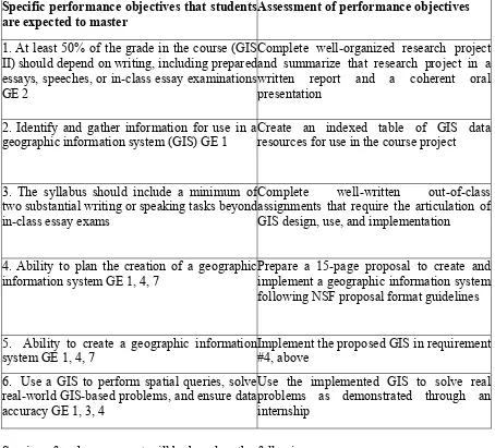
Table 1. Outcome assessment for capstone GIS certificate program (GIS 490/590) Specific performance objectives that students
are expected to master
Assessment of performance objectives
1. At least 50% of the grade in the course (GIS II) should depend on writing, including prepared essays, speeches, or in-class essay examinations GE 2
Complete well-organized research project and summarize that research project in a written report and a coherent oral presentation
2. Identify and gather information for use in a geographic information system (GIS) GE 1
Create an indexed table of GIS data resources for use in the course project
3. The syllabus should include a minimum of two substantial writing or speaking tasks beyond in-class essay exams
Complete well-written out-of-class assignments that require the articulation of GIS design, use, and implementation
4. Ability to plan the creation of a geographic information system GE 1, 4, 7
Prepare a 15-page proposal to create and implement a geographic information system following NSF proposal format guidelines
5. Ability to create a geographic information system GE 1, 4, 7
Implement the proposed GIS in requirement #4, above
6. Use a GIS to perform spatial queries, solve real-world GIS-based problems, and ensure data accuracy GE 1, 3, 4
Use the implemented GIS to solve real problems as demonstrated through an internship
Scoring of each assessment will be based on the following
a. Scoring Articulation to General Studies Performance Objectives
•Quality of information gathered (depth/breadth of research) to address a research problem •Quality of interpretation and evaluation of evidence
•Writing -- appropriate grammar, syntax, punctuation, and use of conventions for citations •Writing -- organization
•Writing -- synthesis and evaluation of information
b. Scoring Articulation to Goals and Course Performance Objectives •Formulation of a geographic problem
•Knowledge of spatial and human factors as displayed in literature review, research and analysis
•Knowledge of location and relationships as displayed in literature review, research and analysis
•Knowledge of geographic principles as displayed in literature review, research and analysis •Cartographic skills
•Data gathering skills (e.g., field methods, archival research)
For the balance of the program, we plan to primarily assess both program and course objectives through a combination of written and practical examinations conducted in the classroom. Further assessment will be conducted by Center faculty through careful evaluation of final presentations made at the conclusion of the Capstone GIS Course and a combination of surveys and interviews to be conducted at the 2- and 5-year post-graduation mark. The latter will include tracking the placement and salaries of program graduates whenever possible by the Interdisciplinary GIS Center. These results will be made available, absent personally identifying information, in subsequent program evaluations.
The Center is a relatively new entity on campus and as of yet, none of its students have reached the 2-year post graduation mark. However, 9 students completed the minor/certificate course of study last year and ALL were gainfully employed prior to their graduation.
II. Division/Department Goals for the Current Year
(This is a report on progress towards goals for the current year. These are operational goals for the unit that are NOT tied directly to student learning outcomes which are reported in the table above. An example might be implementation of a development campaign in conjunction with the DSU Foundation to raise monies for faculty research and travel)
1. Move to the new Center in Kethley and successfully set up all labs and experimental technologies (eg., the Theater of the Mind). (SP 4)
2. Increase student enrollment to 200 SCH’s during the coming academic year. (SP 2)
3. Capture at least $125,000 of soft-money funding beyond the existing Hearin Foundation grant. (SP 4 & 5)
4. Move 2 online courses from the current University of Mississippi based software program to DSU’s Blackboard system and fund and hire 2 visiting professors to assist with online teaching (QEP #2, SP 1)
5. Begin a broader student recruitment program that targets regional students with high school GPA’s of at least 3.2 and ACT scores of at least 26. (SP 2)
IV. Data and information for department: (include narrative of programmatic scope; data)
V. Personnel:
Center awarded “Special Achievement in GIS” by ESRI in August 2006
Center Director, Talbot Brooks, named by GPS World “One of the 50 Professionals to Watch” in May 2007
New position(s) requested, with justification:
Ms. Roshandra Collier’s position as student intern will transition into a GIS Program Manager position. Her duties will include GIS project management and academic unit administration. This change is needed due to increasing enrollment and the number of projects being handled by the Center.
Recommended change of status
Dr. Jeff Dugay will replace Dr. Carlysle Meek as Assistant Director Dr. Robert Austin will join the faculty as a 1-year visiting professor Mr. Pete Gomez will join the faculty as a 1-year visiting professor Dr. Henk VonReissen will join the faculty as an adjunct professor
VI. Degree Program Addition/Deletions and/or Major Curriculum Changes:
Talbot J. Brooks 1714 Bellavista Dr. Cleveland, MS 38732
H: (662) 846-9014 W: (662) 846-4520 C: (662) 402-3772
Summary of Qualifications:
- 20 years experience designing, bidding, negotiating, and implementing complete GIS solutions for municipal, state, and private entities
- National leader in GIS education and well established within the national GIS user community
- Contract negotiation and bidding for $1M+ projects
- 20 years experience designing and implementing GIS/IT/technical solutions - 14 years senior/project management experience
- 20 years research, development, and publication experience with GIS, remote sensing, computer modeling and allied technologies
- Specialization in implementation planning and project management (skilled with MS Project and ESRI PLTS)
- Extensive experience with ArcGIS 9.x and 8.x, ArcINFO, ArcView 3.x, ArcIMS, ArcSDE, ESRI Map Server, Imagine, Idrisi, financial management software, CISCO products (e.g. routers, switches, eHealth), SQL Server, Oracle, Windows, Solaris, Tru64, Linux, HPUX, FORTRAN, Visual Basic, Avenue, Visio, AutoCAD, MS and Corel Office and more.
Recent Significant Professional Accomplishments
- Past President Geospatial Information Technology Association, Arizona Chapter (GITA, 2004-2005), named to National Strategic Planning Commission 2004, 2005, 2006, 2007. - Chair, GITA Education Committee (2007-2008), National Board of Directors 2006-2009. - Member FGDC/URISA Addressing Standards Project Working Group
- Chair, Technical User’s Group, Mississippi Coordinating Council for Remote Sensing and GIS
- Board of Directors, MS Delta Technology Council
- Director for geospatial operations for the 13 October 2004 U.S. Presidential Debate and created USNG map set for Obama Innauguration
- Designed and implemented municipal GIS for Queen Creek and Maricopa, Arizona - Senior technical advisor for OnPoint Systems and inventor of content-on-location
delivery using GPS technology
- Hurricane Katrina GIT Operations Director, Mississippi Emergency Management Agency, Jackson Emergency Operations Center
- Chief Information Officer, Scythe and Spade Co. and inventor of GIS-based agricultural real estate management system
- Developed first 1-year professional master’s degree program for the spatial sciences - Best Speaker Award GITA Annual Conference 29 (2006)
- Member US Dept of Labor “Geospatial Thought Leaders” Roundtable - ESRI “Special Achievement Award in GIS” recipient (2006)
Current Significant Projects
- Cooperative research and development agreement with the US Geologic Survey for development and implementation of the US National Grid
- Developed and implemented 911 mapping systems for 16 counties in Mississippi
- Developed US National Grid street mapping and atlas standards for the Florida Division of Emergency Management
- Development and implementation of a GIS for hazard mitigation and planning in Bolivar County, Mississippi
- Development of an interactive, mobile GIS solution for law enforcement during tactical situations
Professional Employment Experience:
January 2005 – present. Director, Center for Interdisciplinary Geospatial Information Technologies, Delta State University, Cleveland, MS
Responsibilities:
1. Oversee $1.2 M grant establishing a center for geospatial technology development and transfer, education, and outreach
2. Create a rural-outsourcing/cooperative education program that combines education and training with job needs in rural Mississippi and help bring technical project work back to the United States
3. Create significant degree tracks and courses in geospatial information technologies
4. Design and implement spatial technologies for municipal and agricultural management in Mississippi
5. Foster the development and growth of a community of experts for geospatial information technologies
January 2000 – December 2004. Assistant Research Professional, Dept. of Geography, Arizona State University (tenure-track).
Responsibilities:
1. Senior GIT professional responsible for more than 1 million dollars of computing assets and 11 employees
2. GIS administration for SQL Server/ArcSDE and ArcIMS server systems
3. Contract negotiation and bidding. Captured approximately $1.5M in cooperative research and development projects with regional governments and agencies.
4. Complete GIS rollout for the Town of Queen Creek, Arizona Tourism and Sports Authority, ASU Dept. of Public Safety, and Entellus Engineering using combinations of RDBMS, ArcGIS, ArcIMS, ArcSDE, and ArcExplorer.
6. Provide GIS/computer technical expertise to the community through leadership within local and regional user’s groups and dissemination of technology through planning sessions, workshops, professional meetings, colloquia, and other avenues
7. Instructor for intermediate and advanced GIS courses. Course content specializing in the planning and rollout of GIS, spatial databases, and GIS product development
8. Developed Master’s of Applied Science in GIS program of study and undergraduate GIS certificate program for ASU Geography
November 1993 – December 2000. Research technician, University of Arizona. Position sponsored by the United States Department of Agriculture, Agricultural Research Service.
Responsibilities:
1. Manage field research teams
2. Assist with technical management and research/development for agricultural, GIS, remote sensing, and environmental physics experiments
3. Research and publish about the effects of global climate change on crops using results gained through advanced remote sensing, GIS, and allied technology techniques
4. Development of an ecosystem plant growth model (ecosys)
5. Presentation of crop management techniques derived using GIS, remote sensing, and allied technologies to local/state/federal government
6. Developed unique instrumentation for measuring photosynthesis
Societies and Organizations:
- MS Institutes for Higher Learning Geospatial Council (vice-Chairman) - Memphis Area Geographic Information Council
- Geospatial Information and Technology Association (co-Chair, Education Committee) - Urban and Regional Information Systems Association
- Faculty sponsor for Gamma Theta Upsilon, the Geography Honor Society - Association of American Geographers
Academic History:
- 1991, A.S., Biology, with Honors, Rochester Institute of Technology, Rochester, NY - 1993, BS, Biology, Rochester Institute of Technology, Rochester, NY
- 1998, MS, Arizona State University, Tempe, AZ
Other Relevant Training:
- ESRI Courses: Introduction to ArcGIS I, Introduction to ArcGIS II, Creating and Managing Geodatabases, ArcSDE Administration for SQL Server (advanced course), Scripting with Python, Introduction to Programming ArcObjects with VBA
Publications:
Brooks TJ (2006). Getting on the Same Page. Bulletin of the International Association of Emergency Managers, 23 (6) p. 6
Brooks TJ (2006). Affordable Geospatial Technologies for Disaster/Emergency Response. Bulletin of the International Association of Emergency Managers, 23 (7) pp. 1,10
Brooks TJ (2006). Use of GIT During the Response Phase of Hurricane Katrina. Bulletin of the International Association of Emergency Managers, 23 (9) pp. 17-22
Brooks TJ (2005). Responding to Katrina: A Personal Account. Bulletin of the Association of American Geographers, 40 (10) p. 10
Brooks TJ (2005). Predicting Katrina’s Storm Surge Using ArcScene. ArcUser, October- December Issue
Brooks TJ and T Terry (2005). A New Kind of Map Could Help Emergency Response. Interview with Dan Charles, National Public Radio as aired on “Weekend Edition”.
Brooks TJ, Kalkstein A, Goodrich G, and B Hedquist. Use of a geographic information system for assessing depression of diurnal temperature flux due to urbanization. Submitted to Journal of Geophysical Research Letters.
Brooks TJ, Wall GW, Pinter PJ Jr., Kimball BA, LaMorte RL, Leavitt SW, Thompson TL, Mathias AD (2001). Acclimation response of spring wheat in a free-air CO2 enrichment (FACE) atmosphere with variable soil nitrogen regimes. 3. Canopy architecture and gas exchange. Photosynthesis Research, 66: 97-108.
Conley MM, Kimball BA, Brooks TJ, Hunsaker DJ, Wall GW, Pinter PJ, Jr., Adam NR, LaMorte RL, Leavitt SW, and Triggs JM (2000). Free-air carbon dioxide enrichment (FACE) and water-stress effects on sorghum evapotranspiration and soil water content. New Phytologist, 151, 407-412.
Grant RF, Kimball BA, Brooks TJ, Wall GW, Pinter PJ, Hunsaker DJ, Adamsen FJ, LaMorte RL, Leavitt SW, and Thompson TL (2001). Modeling interactions among carbon dioxide, nitrogen, and climate on energy exchange of wheat in a free air carbon dioxide experiment. Agronomy Journal, 93, 638-649.
Hunsaker DJ, Kimball BA, Pinter Jr. PJ, Wall GW, LaMorte RL, Adamsen FJ, Leavitt SW, Thompson TW, and Brooks TJ (2000). CO2 enrichment and soil nitrogen effects on wheat evapotranspiration and water use efficiency. Agricultural Forest Meteorology (104)2:85-100 (2000).
Kimball BA, LaMorte RL, Pinter PJ Jr., Wall GW, Hunsaker DJ, Adamsen FJ, Leavitt SW, Thompson TL, Matthias AD, and Brooks TJ (1999). Free-air CO2 enrichment and soil nitrogen effects on energy balance and evapotranspiration of wheat. Water Resources Research, 35, 1179-1190.
Kimball BA, Morris CF, Pinter PJ, Jr., Wall GW, Hunsaker DJ, Adamsen FJ, LaMorte RL, Leavitt SW, Thompson TL, Matthias AD, and Brooks TJ (2000). Elevated CO2, drought and soil nitrogen effects on wheat grain quality. New Phytologist, 150, 295-303.
Leavitt SW, Pendall E, Paul EA, Brooks T, Kimball BA, Pinter PJ, Jr., Johnson HB, Matthias A, Wall GW, and LaMorte RL (2001). Stable-carbon isotopes and soil organic carbon in wheat under CO2 enrichment. New Phytologist, 150, 305-314.
Leavitt SW, Pendall W, Paul EA, Kimball BA, Brooks TJ, Pinter PJ Jr., and Johnson H (1999). Carbon isotope estimation of carbon turnover in the 1995-1997 FACE wheat experiments. New Phytologist, 305-314.
Matthias A D, Leavitt SW, Thompson TL, Kimball BA, Pinter PJ, Jr., Wall GW, Rauschkolb RS, Ottman RL, Roth RL, Brooks TJ, Adam NR, LaMorte RL, Wechsung G, Wechsung F, Adamsen FJ, Williams DG, Nakayama FS, Hunsaker DJ, Watson J, White SA, and Welzmiller J (1999). Free-air CO2 enrichment effects on wheat and sorghum at Maricopa, Arizona, USA. In International Symposium on Carbon Dioxide and Vegetation - Advanced International Approaches for Absorption of Carbon Dioxide and Responses to Carbon Dioxide. National Institute of Environmental Sciences in Tsukuba, Ibaraki, Japan. March 18, 1999.
Ottman MJ, Kimball BA, Pinter PJ Jr., Wall GW, Vanderlip, RL, Leavitt SW, LaMorte RL, Matthias AD, and Brooks TJ (2000). Elevated CO2 increases biomass under drought conditions. New Phytologist, 150, 261-273.
Pendall E, Leavitt SW, Brooks TJ, Kimball BA, Pinter PJ Jr, Wall GW, LaMorte RL, Wechsung G, Wechsung F, Adamsen FJ, Matthias AD, Thompson T (2001). CO2 stimulates soil microbial respiration. Basic and Applied Ecology, 2:193-201.
Pinter PJ Jr., Kimball BA, LaMorte RL, Wall GW, Hunsaker DJ, Adamsen FJ, Frunmau KFA, Vugts HF, Hendrey GR, Lewin KL, Nagy J, Johnson HB, Leavitt SW, Thompson TL, Matthias AD, and Brooks TJ (2000). Free-Air CO2 Enrichment (FACE): Blower effects on wheat canopy microclimate and plant development. Agriculture and Forest Meteorology 103(4), 319-333.
Sinclair TR, Pinter PJ, Jr., Kimball BA, Adamsen FJ, LaMorte RL, Wall GW, Hunsaker DJ, Adam NR, Brooks TJ, and Garcia RL (2000). Leaf nitrogen concentration of wheat subjected to elevated CO2 and either water or N deficits. Agriculture, Ecosystems And Environment, 79 (1), 53-60.
Triggs JM, Kimball BA, Conley MM, Brooks TJ, LaMorte RL, Pinter PJ Jr., Wall GW, and O’Brien CC (2001). Effects of Free-air carbon dioxide enrichment (FACE) and water stress on the energy balance and evapotranspiration of sorghum. Symposium on Global Change and Climate Variations, Proceedings of the American Met. Society, Albequerque, NM.
Wall GW, Brooks TJ, Adam NR, Kimball BA, Pinter PJ Jr., LaMorte RL, Adamsen FJ, and Leavitt SW (1999). Acclimation response of spring wheat in a free-air CO2 enrichment (FACE) atmosphere with variable soil nitrogen regimes. 2. Acclimation of wheat leaf photosynthesis. Photosynthesis Research, 66:79-95 (2000).
Wall GW, Brooks TJ, Adam NA, Cousins A, Triggs J, Kimball BA, Pinter PJ Jr., Ottmann MJ, Leavitt SW, Matthias AD, William DG, and Webber AN (2000). Leaf Photosynthesis and Water Relations of Grain Sorghum Grown In Free-air CO2 Enrichment (FACE) and Water Stress. New Phytologist, submitted.
Wechsung F, Garcia RL, Wall GW, Kartschall T, Kimball B A, Michaelis P, Pinter PJ, Jr., Wechsung G, Grossman-Clarke S, LaMorte RL, Adamsen FJ, Leavitt SW, Thompson TL, Matthias AD, and Brooks TJ (2000). Photosynthesis and conductance of spring wheat ears: field response to free-air CO2 enrichment and limitations in water and nitrogen supply. Plant, Cell and Environment, 23(9):917 (2000).
Thesis:
Brooks TJ (1998). Effects of free-air CO2 enrichment on wheat canopy architecture and gas exchange. Arizona State University. M.S. degree conferred December 1998.
Selected Speaking Engagements:
“Lessons Learned From The First 10 Days Of Hurricane Katrina: Does The Geospatial Community Currently Have The Capabilities To Effectively Manage Emergency Response Operations?” Invited plenary lecture, European Defense Geospatial Intelligence Conference 2007 (January), London
“Hurricane Katrina and GIS”. Invited keynote lecture, NY GIS Conference 2006, Lake Placid, NY.
“GIS and Disaster/Emergency Response”. Invited pre-conference seminar. Geospatial Information and Technology Association Annual Conference 29 2006 (April), Tampa Bay, FL (Best Speaker Award)
“GIS and Hurricanes Katrina and Rita”. Invited presentation for the Memphis Area Geographic Information Council 2005 (November) Annual Meeting, Memphis, TN
“Making the Saddest Maps in America: the first 240 hours of Hurricane Katrina”. Invited Keynote presentation for the Urban and Regional Information Systems Association (URISA) 2005 (October) Annual Meeting, Kansas City, MO
GIS X01: “Management of Geospatial Information Technologies”. Invited seminar, March 2005 GITA Annual Conference, Denver, CO.
“GIS in the classroom”. Presented to the National Geographic Society’s Arizona Geographic Alliance, April 2003, Tempe, AZ
“Use of GIS for crime analysis”. Presented to Arizona Women’s Law Enforcement Executive Group, November, 2002, Tempe, AZ
Subramanian Swaminathan
CURRENT POSITION:
Education & Projects Coordinator, December 2005 – Present Kethley Hall 146, DSU Box 3325
Center for Interdisciplinary Geospatial Information Technologies Delta State University, Cleveland MS-38733
Email: sswaminathan@deltastate.edu
Ph: 662 846 4522
Serve as Instructor for courses in Geographic Information Systems, Cartography and Applied geospatial technologies at DSU. Organize technical GIS workshops for geospatial training and promotional talks/exhibits on GIS for students and the public.
Administer and manage geodatabases in ArcSDE/SQL Server environment. Develop geospatially-enabled websites within content management systems and publish web-mapping applications through ArcGIS Server with a focus on emergency response, disaster management, demographic analysis, remote data maintenance.
Administrative responsibilities include training and managing a team of staff & student GIS technicians during implementation of geospatial industry standards compliant grants and sponsored projects.
EDUCATION
Doctoral Student, Geography (31 Credits) Arizona State University, May 2004 – Dec 2005
Master of Science, Computer Science. Arizona State University, May 2004
Thesis Title: An Integrated Approach for Face Recognition using Wavelet Transform and Eigenspace Methods
Bachelor of Engineering, Computer Science University of Madras, India, May 2001
GEOGRAPHY COURSEWORK (at ASU Geography)
Interactive and Animated Cartography, Geographic Visualization, Urban Climate, Advanced Research Methods in Geography, Urban Geography, Physical Geography, Contemporary Geographic Thought, Human Geography and Independent research.
ACADEMIC COURSES TAUGHT AT DELTA STATE UNIVERSITY
Computerized Mapping/Cartography – GIS 200/500 every spring, summer and fall semester from fall 2006 to fall 2009
GIS for the Internet and Spatial Databases – GIS 480 – Spring 2008 and expect to continue to offer this class every spring semester in the future.
Business Geographics – GIS 451 – Online every semester since spring 2006
GIS Capstone – GIS 490/590 – co-teach this GIS Internship class with Talbot Brooks every semester.
Serve as a co-instructor for a number of online GIS and REM classes such as Remote Sensing, Remote sensing of water, Digital Image Processing, Aerial Photographic Interpretation and Community Growth.
GRANTS AND SCHOLARSHIPS
Delta State University GIT Center
• GIS Technical lead on U.S. National Grid Project sponsored by U.S. Geological Survey (USGS) under cooperative agreement number 07ERAG0083 – developed web mapping application software tools and completed geospatial data development, to implement the U.S. National Grid and create nation-wide U.S. National Grid 1,000-m polygon layers.
• GIS Project Manager in the development of county wide street base map projects for Phase II Wireless E-911 implementation in Mississippi counties of Attala, Bolivar, Sunflower, Union, Leflore, Lamar, Leake, Washington & Carroll.
• Geodatabase Designer and GIS System Architect for an Enterprise GIS at the Yazoo-Mississippi Levee District Board at Clarksdale, MS (2008-09) and Three Rivers Planning and Development district at Pontotoc, MS (2008-2009). Tasks include recommending spatial data organization to meet project needs and distilling client needs into application requirements and successfully scope and budget all steps for project implementation.
Teaching Assistant, GIS - fall 2005
Introduction to Geographic Information Systems, Arizona State University
Research Assistant, GIS - fall 2004 - spring 2005
Department of Geography, Arizona State University
Research assistant responsibilities included:
1. Conducted research on developing Decision Support Systems for sustainable development in the arid southwestern United States
3. Designed GIS database systems (ArcSDE) for agribusiness management, served as database administrator for customized GIS web portal development. Developed custom tools to enable easy data access and editing for employees on the field.
Research Assistant, Computer Science August 2002 – May 2003
The Distributed Media and Arts Project, Funded by Institute of Studies in Arts and Department of Computer Science & Engineering, Arizona State University.
PROFESSIONAL MEMBERSHIPS
Geospatial Information & Technology Association (GITA) 2004-Present
Association of American Geographers (AAG) 2005
Gamma Theta Upsilon (G.T.U) Lifetime Member International Geographical Honor Society
Institute of Electrical and Electronics Engineers (IEEE). 2002, 2003
Institute of Electrical and Electronics Engineers Computer Society 2003
SERVICE
1. Faculty Senate Representative (1 of 4) in the University Budget Committee – 2009-2010
2. Chair of the Faculty Senate Technology Committee – 2009-2010
3. Member of International Student Admissions Taskforce -2009-2010
4. Serve as a Senator in the Delta State University Faculty Senate – 2008-2010
5. Volunteer at the GIS Desk at the Mississippi State Emergency Operations Center at Pearl, Mississippi – Hurricane Gustav, 2008
6. Volunteer at the Bolivar County Emergency Operations Center at Cleveland, Mississippi – Provide mapping support during adverse weather, after-disaster assistance and search & rescue operations.
INVITED PRESENTATIONS
Presented the keynote address at the Fifth Annual Mid-Tennessee GIS Conference 2006 held at Nashville, TN
Presented at the Annual Mississippi E-911 Coordinators Conference 2006 held at Tunica, MS
TECHNICAL SKILLS
GIS Software (ESRI):
ArcGIS 9.x Desktop, ArcSDE 9.x, ArcGIS Server 9.x, ArcGIS Image Server 9.3.1
Open Source Website Content Management Systems: Typo3
Programming Languages: C#, Microsoft VB for Applications
ArcGIS API for FLEX 1.2
Programming IDE’s: MS Visual Studio 2005 & 2008, Flex Builder 3
Database management systems: Microsoft SQL Server 2000/2005
Multimedia: FLASH 8, Adobe Photoshop, Adobe Illustrator
Mathematical Applications: Matlab 6.5
GPS: NavCom’s Starfire Receiver, Garmin’s Rino 530 & 130
GIS SOFTWARE CERTIFICATES
Cartography in ArcGIS – October 2009
ArcGIS Server Enterprise Configuration and Tuning for MS SQL Server – August 2009
Working with Geometric Networks for Utilities – July 2009
System Architecture Design Strategies – March 2009
Introduction to Programming ArcObjects – June 2008
Data Management in the Multiuser Geodatabase – December 2007
Introduction to the Multiuser Geodatabase – November 2007
Developing Applications with ArcGIS Server using the Microsoft .NET – May 2007
Introduction to ArcGIS Server – May 2007
Introduction to Geoprocessing Scripts Using Python – August 2006