DOI : https://doi.org/10.32628/CSEIT195340
Location Based Augmented Reality Navigation Application
Aditya Anerao, Samridhi Pramanik, Hemraj Bobade, Prof S.N Firame
Sinhgad Institute of Technology and Science, Pune, Maharashtra
, IndiaABSTRACT
We will be integrating Augmented Reality to the traditional maps which will give a new perspective to the maps. We will be using Location based and Markerless Aug- mented Reality which will track the user’s current
location and calculate the destination by calculating distance between them and will facilitate information about the places which appears within the journey. The problem occuring in traditional mapping is not proper direction representation. A traditional map cannot provide a proper view for instance if there is a flyover and a road below it, traditional map cannot differentiate between them and will show both as a single blue line (path) which will confuse the user which way to go. This problem can be solved as we would be providing a 3 Dimensional view . Along with a generous assistant which will help the user in interactive manner. The assistant will direct the user till the actual destination which will solve our above problem whether to take flyover or the road??It will also give information about the places nearby in the route with their details on for example if we come across a restaurant, it will augment name of the cafe its ratings etc which help user to make decision if he requires anything during the journey!!In this way one of the latest technology can be used for the betterment of the user and to solve the problem of users getting confused while finding their destination. Keywords : Augmented Reality, Location Based application, Markerless AR, GPS based application, Real World augmenta- tion, Unity, ARCore, Navigation System, User interaction.
I. INTRODUCTION
Traditionally, Maps have played an important role in our lives since ancient era. Earlier people had difficulties in finding the proper route to the destinations and it used to take a lot of days to reach a place. Then came the manual maps which were designed with all the real time paths and routes with the specific information to reduce the problem of wandering. As the time passed, technology took a boost and every person in the society was able to afford a moblie phone which lead to inventions of many applications to make the life of human easy. And hence we got various applications such as Google Maps, Waze etc as a pathfinder in our very portable mobile phones. A traditional map cannot
II. RELATED WORK
An indoor localisation and navigation system is necessary whenever any person visit any indoor place like malls, indus- tries, museums, art galleries etc. It is necessary as most of the people visit the places for the first time n dont know much about such places. So, An indoor localisation system using Augmented Reality would prove worthy in situations where GPS is denied in such environments. By building such system a lot of crowd can be easily monitored in crowded places like museums, malls etc. We can make use of indoor local references i. e; WiFi/Bluetooth based localisation or Inertial Measurement Unit. Every sensors has their unique character- istics to perform their required task. Inertial Measurement Unit sensors comprises of Accelerometer, gyroscope and compass recording for their localisation. Even after the works of some
Robotics and scientists there isn’t that accuracy
which one wish for. Considering the AR devices like Google Glass and google Cardboard supported by some common smartphones lack with hardware support for heavy processing. In order to overcome this we make use of client-server architecture for such intensive processing. We use User Datagram Protocol (UDP) for communication with the client and server. It is simple and fast enough avoiding the lag for the next index location. Once the connection is established , transfer of data packets takes place. We have proposed a localisation and navigation application using an AR device such as Google Glass and Google Cardboard in connection with an Android smartphone. The client is an Android wearable/hand-held device used to fetch the scene images in real time. The server remotely located contains the internal processing units to perform the required computations. On the server side we have made use of the camera coordinate system. Camera and inertial sensors have same coordinate system as the device.
Nowadays, the Smartphones computational
between the user and POIs. The correct positioning of POIs is safely ensured by the algorithm 4 since it is the base for the clustering algorithm. Algorithm 5 specifies the main calculation about how the POIs are handled. This shows that the mobile augmented reality is one example which shows that mobile applications have become more and more mature.
III. PROPOSED WORK
In order to develop an location based Augmented Reality application we initially require current location of the user. In order to get the location that is latitude and longitude of the user we need to use Google Maps API or Bing Maps API.
Once we get the latitude and longitude of the user we can find the current city or place the person is residing in lets say pune. After that we can get the destination from the user lets say mumbai, by using Google Maps API or Bing Maps API we can get the exact route from pune to mumbai. Now comes the augmented Reality part which is done in unity, to create an assissant which will guide us through path. In order to achieve the movement of the assistant we would require use of gyroscope , accelerometer and magnetometer of the phone which is quite ambigous and requires tremendous research in ”dead reckoning” and ”kalman filter”. Hence, we can make
use of different SDKs such as ARCore or Wikitude which include SLAM technology. The object created in unity or the assistant would travel the distance according to the maneuver type which is provided in the Bing Maps API. And Finally for the Point of Interest section, we can augment 3D objects at the latitude and longitude of that Point of Interest.
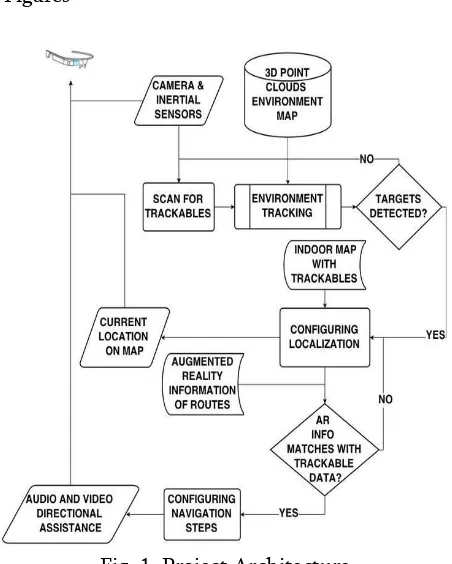
A. Figures
Fig. 1. Project Architecture
IV.DISCUSSION
So starting with the project we had encountered the following SDKs for Augmented Reality. They are
Vuforia, Wikitude, Kudan, Google’s ARcore, Easy
AR, Beyond AR, etc. We tried and implemented using some of these SDKs and discovered some complexities in some of them. In Vuforia we were
not able to get the 3D object’s scaling with respect to the Device’s Camera. Also the Ground Plane
Detection we found it a bit difficult. So we tried Wikitude which helped us getting a virtual plane instead of ground plane detection. But Scaling an
object with respect to user’s position was still a problem. Hence, we went with Google’s ARcore
distance of user w. r. t. destination. So for that we found out 2 solutions. First, Google Maps Distance-Matrix APIs and Second was we count the distance travelled with the help of Pedometer APIs.
V. STEPS FOR PROJECT EXECUTION
1. The Application will first check if our GPS and
Mobile-Data Service is running or not.
2. If it is working the Application will start
otherwise it will display Service Unavailable to User.
5. Then the Application will give the shortest route
to the preferred destination and Augmentation of 3D object and route will start rendering on walking directions on top of the real world and help you figure out which way you need to go. In addition to directions, the new AR mode can help identify nearby places, too. This new feature helps the user to get a better view and also an interactive screen getting a nearby cafe and its ratings or a shell petrol
pump nearby would give user an experience with less hindrances in their way and enjoy their journey scheerfully.
VII. ACKNOWLEDGMENT
We are profoundly grateful to Prof. S. N. Firame for her expert guidance and continuous encouragement throughout to see that this project rights its target since its commence- ment to its completion. We would like to express deepest appreciation towards Dr.Rajesh Prasad, Principal, Sinhgad Institute of Technology And Science, Dr. A. P. Adsul, Head of Department of Information Technology and Prof. S. A. Patel, Project Coordinator whose invaluable guidance supported us in completing this project. At last we must express our sincere heartfelt gratitude to all the staff members of Department of Information Technology who helped us directly or indirectly during this course of work.
VIII. REFERENCES
[1]. Rudiger Pryssa, Philip Geigera, Marc Schicklera, Johannes Schobela, Manfred Reicherta Advanced Algorithms for Location-Based Smart Mo- bile Augmented Reality Applications .
[2]. Wolfgang Narzt, Gustav Pomberger, Alois Ferscha Dieter Kolb, Reiner Muller, Jan Wieghardt Horst, Hortner, Christopher Lindinger Augmented reality navigation systems
[3]. QIN Yong-xu, LIU Jia-min, QIU Hui, YAN Bo, JIN Chang-xu Campus Navigation System Based on Mobile Augmented Reality
[5]. Ching-Sheng Wang, Shih-Hui Hung, Ding-Jung Chiang A Markerless Augmented Reality Mobile Navigation System with Multiple Targets Display Function
[6]. JongBae Kim and HeeSung Jun Vision-Based Location Positioning using Augmented Reality for Indoor Navigation
[7]. Rakshitha Raghavendra GPS Navigation using
ARKit and Google Maps
https://medium.com/@rakshitha42753/gps − navigation − using − arkit − and − google − maps − cf 19dc3b99f 9
Cite this article as :
Aditya Anerao, Samridhi Pramanik, Hemraj Bobade, "Location Based Augmented Reality Navigation Application", International Journal of Scientific Research in Computer Science, Engineering and Information Technology (IJSRCSEIT), ISSN : 2456-3307, Volume 5 Issue 3, pp. 241-245, May-June 2019.
Available at doi :
https://doi.org/10.32628/CSEIT195340