D
ETERMININGD
ISASTERD
ATAM
ANAGEMENTN
EEDSIN A
M
ULTI-D
ISASTERC
ONTEXTby
Elizabeth A. Harris William J. Rasdorf Debra F. Laefer
Final Report
NSF Project Supplement CMS-0451461
To NSF Grant CMS-0353175
Department of Civil Engineering North Carolina State University
Raleigh, NC
ACKNOWLEDGEMENTS
This work was supported by NSF project CMS-0353175 and by an NSF Graduate Research Fellowship. Any opinions, findings and conclusions or recommendations expressed in this material are those of the author(s) and do not necessarily reflect those of the National Science Foundation.
EXECUTIVE SUMMARY
In the last four decades, the economic loss from natural hazard disasters has increased ten-fold. The increasing human and economic impacts of disasters have intensified efforts on the global, national, state, and local levels to find ways to reduce these impacts. Improved collection and management of disaster data can help support planning and decision-making by first responders and emergency managers during all phases of the disaster cycle. The goal of this report is to establish what disaster-related data are needed in the planning, response, and recovery for multiple types of disasters, with a focus on the data needs in the state of North Carolina.
There is a vast amount of information available from all phases of a disaster. Unfortunately, without proper collection, documentation, and storage, the information is either completely lost or is not transformed into functional data. Often, data that are critical for developing better mitigation efforts is not collected because much of it is short-lived and is lost prior to collection. Increased use of instrumentation, such as water level gauges and data collection and analysis software, can aid in collecting and disseminating real-time critical disaster data. The deployment of rapid-response data collection teams immediately after a disaster event can also improve the quantity and quality of data obtained during a disaster. Disaster management systems help first responders and emergency managers formulate and discriminate their decisions before, during, and after a disaster and therefore can serve as a way to organize, analyze, and disseminate critical disaster data.
Groups of researchers and emergency management professionals in NC are trying to improve the collection and dissemination of disaster data in order to improve disaster preparation and response. Researchers at North Carolina State University (NCSU) were looking at all phases of data collection in a multi-disaster context. Another group, the North Carolina Institute of Disaster Studies, hosted two previous workshops to better coordinate collaboration between emergency responders and academics throughout the state. These efforts, as well as the disaster data collection research efforts of the North Carolina Emergency Management Division, resulted in a need to gather members of the academic and emergency management community together to obtain a more accurate picture of multi-disaster data collection and use, and to develop the foundation for a consensus on areas of disaster data management that needed improvement. A Disaster Data Workshop, held at NCSU November 4-5, 2004, was chosen as one way to address the data collection and dissemination issues in a context of broad, statewide participation.
The workshop planning committee determined that the approximately 30-40 workshop participants would discuss four different disasters in-depth. The four disasters chosen by the workshop planning committee to discuss in the workshop were hurricane and tornado wind, flood, ice storm, and intentional explosion. The first three disasters chosen are the most frequent natural disasters in NC, while the intentional explosion disaster was chosen so that an intentional man-made disaster would be included in the workshop.
• Understand local data needs and opportunities,
• Establish clear models of organizational participation in collection and use,
• Define a common data set for multiple disasters, and
• Lay the groundwork for establishment of data collection teams.
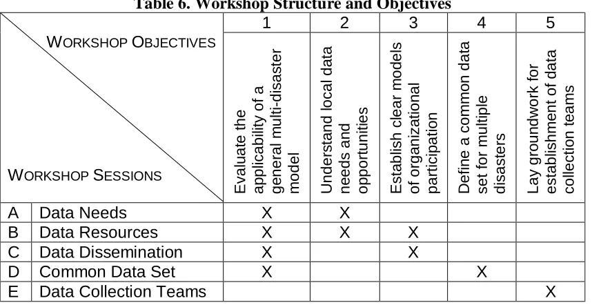
The workshop’s structure was based on meeting the five workshop objectives within the available time. The five sessions of the workshop were data needs, data resources, data dissemination, common data set, and data collection teams.
From the participants’ discussions on disaster data during the workshop sessions, some common themes emerged. The emerging themes on data needs, resources, and data dissemination were used to create and implement a multi-disaster data model. The model was developed by the workshop planning committee. The discussions on data needs and resources also led to the identification of data items that participants in each of the four disaster groups indicated were needed for their assigned disaster. These needed data items form a common data set for the four disasters investigated by the workshop, as well as possibly for other disasters not investigated. Also generated from the workshop discussions were a set of disaster data collection and management priorities for NC.
From this research study, from the NCSU Disaster Data Workshop results, and from previous workshops and disaster management systems efforts, several conclusions can be drawn about disaster data and its management. Existing data collection and management efforts focus primarily on inventory data, since this information is available regardless of a disaster event. The development of data collection teams and a data repository in NC is needed and would contribute to disaster research and emergency management efforts. The four areas model developed from the workshop allows all of the data items the workshop participants could think of to be assigned to a data area. The common data set model developed from the workshop is also biased toward the data needs for NC, and may need to be modified for application in other regions. Also, a disaster data collection and management cycle was developed from the workshop discussions. This cycle can serve as an agenda for the development and operations of both disaster data collection teams and a common disaster data repository.
TABLE OF CONTENTS
PAGE ACKNOWLEDGEMENTS ... I EXECUTIVE SUMMARY...II LIST OF TABLES ... VII LIST OF FIGURES ...VIII
INTRODUCTION ...1
Disasters ...1
Disaster Types...2
The Disaster Cycle ...3
Major Disaster Mitigation and Response Organizations...6
Study Goal and Objectives ...7
Disaster Data: Collection, Coordination, and Use ...7
Data Collection and Transformation ...7
Instrumentation ...8
Coordination of Data Collection Efforts ... 10
Disaster Management Systems ... 10
HAZUS-MH ... 11
Incident Management Systems ... 12
Kovel Disaster Database Model ... 13
Southwestern Indiana Disaster Management System ... 15
Summary ... 17
Data Resources... 20
CAMEO ... 21
Florida Shelter and Road Status Databases... 21
Southern California Earthquake Data Center... 21
DISASTER DATA RESEARCH BACKGROUND... 23
Earthquake Engineering Research Institute... 23
North Carolina Institute of Disaster Studies... 23
Greenville NCIDS Workshop... 24
Charlotte NCIDS Workshop... 24
North Carolina Emergency Management Division... 25
North Carolina State University... 25
Case for 2004 NCSU Disaster Data Workshop ... 27
WORKSHOP SCOPE AND OBJECTIVES... 28
Workshop Scope ... 28
Workshop Objectives... 29
WORKSHOP STRUCTURE ... 31
WORKSHOP FINDINGS ... 34
Infrastructure... 34
Population... 35
Response Resources ... 35
Data Dissemination ... 35
Ice Storm Group ... 36
Hazard ... 36
Infrastructure... 36
Population... 36
Response Resources ... 37
Data Dissemination ... 37
Flood Group ... 37
Hazard ... 38
Infrastructure... 38
Population... 38
Response Resources ... 39
Data Dissemination ... 39
Explosion Group ... 40
Hazard ... 40
Infrastructure... 40
Population... 41
Response Resources ... 41
Data Dissemination ... 42
Internet Contacts ... 42
DISASTER DATA MANAGEMENT POLICY ISSUES ... 44
Data Collection Issues ... 44
Data Format Issues ... 45
Data Dissemination Issues ... 46
Data Maintenance Issues ... 46
DATA COLLECTION TEAMS... 48
Team Objectives... 48
Team Requirements ... 49
Team Limiting Factors ... 49
Team Types ... 50
WORKSHOP RESULTS... 51
Multi-Disaster Data Model ... 51
Development of New Four Areas Model ... 51
Model Implementation... 52
Workshop Common Disaster Data Set... 54
Common Multi-Disaster Data Model ... 54
Team Data Collection ... 56
Disaster Data Management... 58
CONCLUSIONS ... 59
North Carolina Recommendations... 61
General Recommendations... 61
REFERENCES ... 63
APPENDICES... 66
Appendix A HAZUS-MH Default Inventory Information ... 68
Appendix B Disaster Data Resources Links... 74
Appendix C Workshop Planning Committee Members, Speakers, and Facilitators ... 75
Appendix D Participant Invitation Letter... 76
Appendix E Workshop Participants List ... 78
Appendix F Workshop Agenda ... 79
Appendix G Original Multi-Disaster Data Model List for Small Group Discussions ... 82
Appendix H Participant Information Sheet... 83
Appendix I Blank Small Group Discussion Recording Form ... 85
Appendix J Sample Earthquake Small Group Discussion Recording Form ... 87
Appendix K Workshop Presentation by R. Jay Love of EERI ... 89
Appendix L EERI Data Collection Team Member Application ... 100
Appendix M Data Set Terms Definitions ... 103
Appendix N Four Areas Model from Workshop Participant Comments Only ... 105
LIST OF TABLES
Table 1. IFRC and FEMA Disaster Types 2
Table 2. Disaster Types and Causes 4
Table 3. Southwestern Indiana DMS Information Needs 16
Table 4. SIDMS Data Resources for Incentives Information Need 19 Table 5. NCIDS Focus Areas Identified at the 2003 Greenville Workshop 24
Table 6. Workshop Structure and Objectives 31
Table 7. Outline of Workshop Structure 32
Table 8. Internet Contacts for Organizations Mentioned by Workshop Participants 42
Table 9. Original Multi-Disaster Data Model 51
Table 10. Four Areas Model from Workshop Comments and Assessment 53
Table 11. Common Data Sets from Workshop 55
LIST OF FIGURES
Figure 1. Six Phases of the Disaster Management Cycle 5
Figure 2. Transformation of Data into Knowledge 8
Figure 3. HAZUS-MH Analysis Levels 11
Figure 4. Role of the Three Disaster Databases in the Five Step Data Analysis Process 15 Figure 5. Proposed Architecture for Southwestern Indiana Disaster Management System 17
Figure 6. Illustration of Common Data Sets 27
INTRODUCTION
According to United Nations estimates, each year 100,000 lives are lost due to disasters caused by nature, and the global cost of disasters will top $300 billion annually by 2050 (UNISDR, 2002). In the last four decades, the economic loss from natural hazard disasters has increased ten-fold (McDonald, 2003). Population shifts from rural to urban and suburban areas have both increased the density of inhabited areas and encouraged people to move into areas that are more vulnerable to natural disasters. The increasing human and economic impacts of disasters have intensified efforts on global, national, state, and local levels to find ways to reduce these impacts.
Disasters
There are several existing definitions for a disaster. Disaster researcher Charles E. Fritz has defined a disaster as:
“An event concentrated in time and space, in which a society, or a relatively self-sufficient subdivision of a society, undergoes severe danger and incurs such losses to its members and physical appurtenances that the social structure is disrupted and the fulfillment of all or some of the essential functions of the society is prevented.” (Tierney, 2001)
An alternate, but similar definition is that “a disaster can be defined as an event, either natural or man-made, which has the ability to destroy life, natural landscape, and man-made infrastructure. The same event, in different circumstances, could be a source of scientific data or a deadly catastrophe. It all depends on where it took place and how it was perceived” (McDonald, 2003). A simpler, systems-focused definition of a disaster is that it involves demands that exceed capabilities (Tierney, 2001).
These three definitions emphasize that a disaster must meet two criteria. First, a natural hazards or man-made event needs to be powerful enough to cause human, natural, or infrastructure damage, and second, this event must actually cause human and infrastructure damage that severely impacts the function of society. For example, a powerful earthquake (6.5 magnitude) in a remote area of China might not be considered a major disaster if only minor human and infrastructure damage occurs, but if that same earthquake occurred in an urban center, the devastation and resulting loss of lives would qualify the event as a major disaster.
Disaster Types
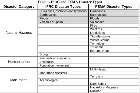
There is no single agreed upon standard list of disaster types within the disaster research community. Depending on both the mission of the organization or researcher(s), the selected definition emphasizes certain disaster categories, while excluding others. For example, the Federal Emergency Management Agency’s (FEMA) list of disaster types consists mostly of natural hazards and man-made disasters, including those man-made disasters caused by terrorism and hazardous materials. The International Federation of Red Cross and Red Crescent Societies’ (IFRC) disaster types focus more on humanitarian disasters than does FEMA’s list, probably because the IFRC’s main mission is medical and humanitarian care.
Table 1 presents the IFRC’s and FEMA’s lists of disaster types (IFRC, 2005, FEMA, 2005a). Disaster types that are included in both organizations’ lists have been shaded and displayed in the same row, and disaster types that are in the same category have been grouped together. There is commonality of the two lists for only four natural disaster types: hurricanes, earthquakes, floods, and volcanoes. FEMA’s list includes many more natural hazards, such as wildfires and tsunamis, than IFRC’s list. However, FEMA does not list any humanitarian disasters, such as famine and population movement, as disaster types. FEMA and IFRC both include man-made disasters on their lists of disaster types, but FEMA’s list goes into more detail and includes nuclear and terrorism disaster types among others.
Table 1. IFRC and FEMA Disaster Types
Disaster Category IFRC Disaster Types FEMA Disaster Types Hurricanes, cyclones and typhoons Hurricanes
Earthquakes Earthquakes
Floods Floods
Volcanic eruption Volcanoes Fires Wildfires Landslides Thunderstorms Winter Storms Tornadoes Tsunamis Extreme Heat Natural Hazards Drought Famine/food insecurity Epidemics Humanitarian Population movement Multi-Hazard Man-made disasters Terrorism Technological Dam Safety Hazardous Materials Man-made Nuclear
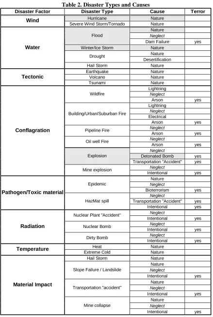
types for this study. The list of disaster types considered herein, and their cause(s) are given in Table 2. This comprehensive list was compiled from accumulation of the ICRC and FEMA disaster type lists as well as from additional research and research group discussion. The list introduces a new term, disaster factor, which is defined as the agent causing human, natural, or infrastructure damage. For example, both earthquakes and volcanoes are caused by tectonic changes in the earth’s crust.
The Disaster types listed in Table 2 are grouped by the disaster factor, and are biased towards disasters that affect infrastructure. Classifying the disaster types by disaster factor allows disaster types that have similar damaging effects on infrastructure to be grouped together. It also presupposes that if the disaster types have a similar damaging effect on infrastructure they will also require similar preparation, response, and recovery efforts from the disaster community. As shown in Table 2, each disaster type can have multiple causes, with the most common causes being nature, neglect, and intentional. Disasters caused by nature, such as a flood, can be mitigated against to reduce damage, but some damage will still occur because the disaster event cannot be entirely prevented. Eliminating accidental human error through improved resource management can theoretically prevent disasters caused by neglect, but in reality accidents will still occur, causing the mitigation efforts already in place for nature-caused disasters to also assist in mitigating the neglect-caused disasters.
Intentional disasters are the most difficult to prepare for because they depend on a human deliberately harming infrastructure or people by causing a disaster event. Not all intentional disaster events are terrorism, but all terrorism is intentional. For example, one can intentionally commit arson by setting fire to a structure, but unless this person is attempting to make a political or terrorist statement, it is simply a criminal act. The line between criminal and terrorist acts is still being defined and discussed in the American legal system and in government. All disaster type/disaster cause combinations that could reasonably be precipitated as a terrorist act are indicated by “yes” in the Terror column in Table 2.
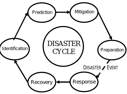
The Disaster Cycle
The disaster cycle includes the steps taken by a society before, during, and after a disaster event to manage a disaster. The disaster cycle can be characterized as consisting of of six phases, identification, prediction, mitigation, preparation, response, and recovery (Pradhan, 2003). The order of the phases and their relationship to the disaster event is shown in Figure 1 (Pradhan, 2003). Each phase of the disaster cycle will differ in content based on the type of disaster being managed. Therefore, each disaster type will have its own disaster cycle that reflects what is necessary to manage that particular disaster type.
Table 2. Disaster Types and Causes
Disaster Factor Disaster Type Cause Terror
Hurricane Nature Wind
Severe Wind Storm/Tornado Nature Nature
Neglect
Flood
Dam Failure yes Winter/Ice Storm Nature
Nature Drought
Desertification Water
Hail Storm Nature Earthquake Nature
Volcano Nature
Tectonic
Tsunami Nature
Lightning
Neglect
Wildfire
Arson yes
Lightning
Neglect
Electrical Building/Urban/Suburban Fire
Arson yes
Neglect
Pipeline Fire
Arson yes
Neglect
Oil well Fire
Arson yes
Neglect
Detonated Bomb yes Explosion
Transportation "Accident" yes
Neglect Conflagration
Mine explosion
Intentional yes Nature
Neglect
Epidemic
Bioterrorism yes
Neglect
Transportation "Accident" yes Pathogen/Toxic material
HazMat spill
Intentional yes
Neglect
Nuclear Plant "Accident"
Intentional yes
Neglect
Nuclear Bomb
Intentional yes
Neglect Radiation
Dirty Bomb
Intentional yes
Heat Nature
Temperature
Extreme Cold Nature Hail Storm Nature Nature
Neglect
Slope Failure / Landslide
Intentional yes Nature
Neglect
Transportation "accident"
Intentional yes Nature
Neglect Material Impact
Figure 1. Six Phases of the Disaster Management Cycle
After the threatened physical and human infrastructure is recognized in the identification phase, the level of damage to the threatened physical and human infrastructure is determined in the prediction phase. The prediction phase consists of conceiving of a danger and assessing its potential impacts on the community. Physical impacts to the community could include property loss and utility service interruption. Human community impacts may include predicting the possible loss of life due to a disaster and calculating the number of citizens that need to be evacuated from the area.
The mitigation phase seeks to reduce the predicted effects of a disaster event by developing and implementing plans to minimize damage to physical and human infrastructure. Physical infrastructure mitigation efforts could include installing plywood to cover windows and raising the elevation of houses in the floodplain. Backup generators for hospitals and protective garments for emergency workers are examples of human infrastructure mitigation efforts.
Prior to a disaster event and after the identification, prediction, and mitigation phases have been completed, the preparation phase will occur. The preparation phase includes the activities needed to prepare for disaster emergencies that cannot be fully mitigated against. For example, scattering salt and sand on roads and stacking sandbags around buildings are ways to prepare the physical infrastructure for a disaster. Preparations to prevent human casualties can include notifications, evacuations, and containment strategies.
Once the disaster event has begun, the response phase commences. The response phase consists of a set of actions constituting a reply or a reaction during and immediately following a disaster. The government and citizens make attempts to protect and rescue impacted human and physical infrastructure as the disaster unfolds.
The recovery phase begins shortly after the end of a disaster event. This phase includes the restoration of disaster-stricken areas and communities after the disaster event. Houses and businesses are repaired, lost utilities are restored, and the physical and psychological healing of humans also occurs.
DISASTER CYCLE
Identification
Prediction Mitigation
Recovery Response
Preparation
Major Disaster Mitigation and Response Organizations
In the United States, the government agency responsible for national disaster management is the Federal Emergency Management Agency (FEMA). FEMA, created in 1979, was an independent US government agency until 2003 when it was assigned to the Department of Homeland Security. FEMA is involved in coordinating state and local efforts for all six disaster cycle phases. After an event is declared by the President to be a federal disaster, affected state and local governments as well as affected citizens and businesses can request financial assistance under the Robert T. Stafford Disaster Assistance and Recovery Act. FEMA is also involved in funding first responder training and emergency planning efforts.
On the international level, the International Federation of Red Cross and Red Crescent Societies (IFRC) and the United Nations (UN) are involved in global disaster management. The IFRC, founded in 1919, focuses primarily on providing humanitarian relief through its member societies during and after disaster events. The IFRC has two sets of specially trained teams, the Emergency Response Units and the Field Assessment and Coordination Teams that provide specialized volunteers, needed equipment, and trained disaster managers to affected areas. The IFRC also maintains a Disaster Management Information System on the Internet that has disaster management tools and databases and a Disaster Relief Emergency Fund for assistance (IFRC, 2005).
Within the UN, two groups, the United Nations Office for the Coordination of Humanitarian Affairs (OCHA) and the International Strategy for Disaster Reduction (ISDR) play a role in disaster mitigation and response. The ISDR is focused on the first four phases of the disaster cycle (Identification, Prediction, Mitigation, and Preparation). The ISDR has a goal of “reducing human, social, economic and environmental losses due to natural hazards and related technological and environmental disasters” (UNISDR, 2005). The ISDR runs an international disaster risk reduction training program that seeks to achieve the following four objectives:
• Increase public awareness to understand risk, vulnerability, and disaster reduction globally,
• Obtain commitment from public authorities to implement disaster reduction policies and actions,
• Stimulate interdisciplinary and intersectoral partnerships, including the expansion of risk reduction networks, and
• Improve scientific knowledge about disaster reduction.
Study Goal and Objectives
During all phases of the disaster cycle, current and accurate disaster data is necessary to support planning and decision-making by first responders and emergency managers. The goal of this study is to determine what disaster-related data is generally needed in for all disaster phases for multiple types of disasters, with a focus on the data needs in the state of NC. In order to determine these disaster data needs, this project seeks to meet the following objectives.
1. Identify existing disaster data collection and management systems and determine what data they collect and use,
2. Study the results of previous disaster-related organizational efforts to deal with disaster data,
3. Generate a common disaster data set based on research from this study as well as work by others, and
4. Recommend how to apply the common disaster data set in future work and studies, for example, serving as the initial baseline data set for disaster management systems and as a data repository for disaster data collection teams.
The first objective provides a sense of what the current status of disaster data collection and management system efforts is, as well as an identification of what data items are collected or included in these efforts. The disaster data work done by the Earthquake Engineering Research Institute (EERI), the North Carolina Institute of Disaster Studies (NCIDS), the North Carolina Emergency Management Division (NCEM), and North Carolina State University (NCSU) is examined to meet the second objective. The experiences of NCIDS and NCEM are especially helpful in determining disaster data needs in NC.
The third objective is the main research focus of this study. It involves the synthesis of the common data items identified at a disaster data workshop held in Raleigh, NC and the disaster data items categorized in other research efforts. Issues of disaster data format, data dissemination, team data collection, and data management for the common data set are discussed. Recommendations regarding these issues are made to satisfy the fourth objective. The rest of this report addresses and discusses each of the preceding objectives, beginning with the first objective, to describe existing disaster data collection and management systems and what data they collect and use.
Disaster Data: Collection, Coordination, and Use
A disaster creates an information need by governmental, business, and academic communities for both efficient disaster response and improved preparedness for future disasters. How this information is collected, stored, managed, and disseminated influences the effectiveness of disaster management during each of the six phases of the disaster cycle.
Data Collection and Transformation
transformed into functional data. For example, immediately following Hurricane Isabel in 2003, seven different federal and state agencies documented the coastal damage along the Outer Banks in NC. This information was collected in multiple formats (video, orthophotography, satellite imagery) and typically lacked reference locations and dates, thereby making it unusable for further analysis. Because the coastal damage information was poorly documented and labeled, it could not be converted from raw information to functional data. Manipulating and analyzing functional data then creates practical knowledge, as shown in Figure 2, which can be applied to mitigation and prevention of future disasters.
Figure 2. Transformation of Data into Knowledge
Often, the critical data necessary for developing better disaster mitigation efforts is not collected because much of the disaster information is short-lived. If it is not actually collected it may be lost. For example, information on structural damage due to a hurricane is lost within a week of the event, because owners begin to repair or demolish the structure. Similarly, high water marks are often lost with the first subsequent rainfall. Methods for collecting this data before it is lost must be developed.
Critical data is also not collected because the existing data collection infrastructure is not fully utilized. For example, all bridges in NC are already outfitted with sensors to measure temperature, but they are not equipped with sensors to measure wind speed or water level, which are critical data to document hurricanes. Fully utilizing current data collection opportunities can prevent data from disappearing during a disaster event. Adding data collection capacity maximizes the amount of useful information gathered while minimizing the associated cost. Other similar cost sensitive data collection ideas need to be pursued.
Instrumentation
Instrumentation facilitates data collection before, during, and after a disaster. The capabilities for real-time processing of sensor-collected data using computers and wireless networks not only exist but also are currently being implemented. Data collecting sensors can either be installed prior to a disaster event to monitor conditions during an event in real-time or they can be deployed in response to an event to assist in response and recovery efforts. For example, cameras attached to robotic snakes are sensors that can be used to enter collapsed buildings after a disaster and search for victims. Sensor networks need software applications that can quickly retrieve and analyze sensor data for interpretation by emergency management professionals. Prior to a disaster event, instrumentation should be installed and tested for functionality. Installed sensors can be used to obtain the base level conditions in the system being measured. Before an event is also a good time to test the interoperability of sensors, high-speed data servers, and data collecting software. The data collecting software can be interfaced with a spatial database to enable better visualization in a GIS of the system being measured during a future disaster event. Spatial data for a sensor can come from a Global Positioning System (GPS) unit reading when it
Functional Data
is installed or inspected. Planning and scheduling software that is used to coordinate the disaster response should also be tested prior to a disaster event.
Many types of sensors and sensor networks are used to collect disaster data during an event. In the earthquake and meteorological research fields, the use of sensors such as accelerographs and Doppler radar, respectively, is highly developed. The California strong motion instrumentation program (CSMIP) is a statewide network of accelerographs installed in geologic materials and in over 900 structures, such as buildings, hospitals, bridges, dams, utilities and industrial facilities (CSMIP, 2005). Data from the accelerographs, including acceleration, velocity, displacement, and duration of motion, is either collected from each instrument manually or is relayed to the CSMIP headquarters via modem whenever ground or structural motion is detected. Ground motion data is used to rapidly create maps showing the levels of ground motion in the affected area; structural motion data is used to analyze the performance of structures under earthquake loads and to alert headquarters of any sensed large motion.
In the Houston area, next generation radar (NEXRAD) real-time rainfall estimates are used in hydrologic models to predict flooding levels (Bedient, 2003). Other areas, such as flood control, are beginning to develop. In Palo Alto, California, a real-time, web-based, flood warning system has been developed using water level sensors (on bridges), rain gauges, flood basin detectors, tide monitors, and a closed circuit television camera (FHWA, 2003).
Instrumentation of structures typically either involves monitoring for structural motion (e.g. the CSMIP) or to monitor structural health by installing sensors that measure the stress, strain, or both on a structural member. Structural health efforts generally focus on critical structures such as bridges, dams, important large buildings, and buildings with a history of failure problems because monitoring all buildings would be costly and require intensive data processing. In the Sacramento River delta in California, a levee that is in danger of failing has been successfully outfitted with real-time sensors that identify distortion and notify crews that emergency repairs are necessary (Broad, 2005). Recently, the use of fiber-optic sensors to monitor cracks, temperature change, strain, incline, acceleration, and corrosion has become more common because these sensors are inexpensive, rugged, lightweight, and can have many sensors installed on a single fiber (Casas, 2004). Advances in wireless communications are also making it easier to monitor structural health (Lynch, 2003). After a disaster occurs, remote sensing techniques, such as LIDAR, can be used to judge the extent of structural damage and generate three-dimensional building models.
A real-time sensor system designed to effectively collect important data during a disaster should be designed with the most likely disaster threats in mind. A basic sensor system could include temperature, lake and stream water levels, wind speed, wind direction, and other meteorological factors that promote real-time information on wind and water levels, two common causes of disaster damage.
collection teams in the field can be equipped with GPS-enabled personal data assistants (PDAs) that have data collection forms and analysis software pre-installed. For example, these PDAs can collect data about the level of building damage and the location (through GPS) of the damaged structure. Spatial database software can take the data collected from the PDAs and display it in a GIS to inform decision makers and researchers. Sensors, sensor networks, spatial sensors (GPS), and data management software assist in collecting and processing attribute and spatial information about hazards threatening an area, levels of damage, and the quantities and locations of response resources.
Coordination of Data Collection Efforts
The lack of coordination and standards for information collected during disasters prevents important disaster research efforts from advancing. The problems in collecting short-lived disaster data stem from a lack of awareness of what data to collect and a lack of pre-disaster coordination between agencies. Presently in NC, there is no pre-disaster organization to form disaster response teams on the local and state level to coordinate data collection for a particular disaster.
Ideally, data collection teams would be comprised of government agency representatives, expert university faculty, and their research assistants, all of whom have been pre-coordinated into teams to respond quickly to collect disaster data. Furthermore, there needs to be a predetermined agreement within the disaster research community on what data should be collected for a particular disaster and how that should be done (format, extent, geo-spatial reference, etc.). The teams would have to be organized to ensure that the correct data is collected and that there are enough team members to do so. Presently, when a disaster occurs, only a few national disaster response teams with highly limited scopes of interest, such as for earthquake response, have been pre-coordinated for deployment.
Disaster Management Systems
Disaster management systems (DMSs) typically consist of one to three main parts; a database of disaster data, a set of procedures for disaster response, and models for predicting the extent of disaster damage (using the database). DMSs addressing one or two of the main parts typically focus on one or several of the disaster cycle phases, while DMSs that include all three parts may focus on all phases of the disaster cycle. Most DMSs focus on multiple disaster types so they can be applicable in multiple disaster situations. Four disaster management systems are discussed in this section.
• HAZUS-MH,
• Incident Management Systems,
• Kovel Disaster Database Model, and
• Southwestern Indiana Disaster Management System.
− DMS characteristics,
− Data items utilized in the DMS, and
− Relevance of the DMS to this project.
HAZUS-MH
FEMA’s hazard modeling tool, HAZUS-MH, short for HAZards U.S. Multi-Hazard, contains models for estimating potential losses from floods, earthquakes, and hurricane winds (FEMA, 2005b). The original HAZUS released in 1997 only considered earthquakes. HAZUS-MH is a Geographic Information System (GIS)-based system that classifies buildings and lifeline systems (utilities) according to a nationally standardized methodology. There are three levels of analysis refinement, or detail to HAZUS-MH, depending on the level of detail of the database from which HAZUS-MH draws (either national or local level detail data) and the sophistication of the modeling (Hooke, 2000). The three analysis levels of HAZUS-MH are illustrated in Figure 3 (FEMA, 2005b).
Figure 3. HAZUS-MH Analysis Levels
For Level 2 and 3 analyses, the hazard and inventory data is augmented with local information and vulnerability data, which requires refinement for the local area. To enter local data into HAZUS-MH in order to complete a Level 2 analysis, FEMA provides three tools.
1. The Inventory Collection Tool (InCAST) is a software application to facilitate the collection of building-specific data for HAZUS-MH.
2. The Building Inventory Tool (BIT) is used to import building data (e.g. from a tax assessor).
3. The Flood Information Tool (FIT) helps users manipulate local flood data into the required HAZUS-MH flood model format (FEMA, 2005b).
A Level 3 analysis requires not only local data, but also an adjustment of the HAZUS-MH program parameters for a specific hazard situation, location, or both.
HAZUS-MH, and its preceding program, HAZUS, has been used nationally to tackle earthquake, wind, and flood disasters. In the Portland, Oregon metropolitan area a Level 2 HAZUS analysis was completed in 1999 to model the potential damage to local buildings and lifelines due to an earthquake. The analysts chose to do a Level 2 analysis because the baseline data included with HAZUS had been aggregated at a lower level of detail than the analysis required (Hasenberg, 1999). A building survey of 50,000 non-single family residential buildings was added to HAZUS, as well as information about essential facilities and lifelines (medical care facilities, emergency response facilities, and schools). In Austin, Texas in 2000, the Flood Information Tool (FIT) and a database of property values by parcel and finished floor elevations was used in a HAZUS-MH analysis to estimate flood depths. Knowing the flood depths, HAZUS-MH then was able to estimate loss in terms of the amount of flood damage that would occur in each building and the cost of that damage for a flood of a particular magnitude. This information in turn was used to set priorities for and justify flood mitigation efforts in Austin (Srinivasan, 2003).
In terms of this disaster data study, HAZUS-MH provides guidance with respect to possible common data sets and potential data formats. The list of data items included in the baseline data of the HAZUS-MH program, shown in Appendix A, provides a preliminary data set for the common disaster data set this study is attempting to develop. However, the data sets in HAZUS-MH focus primarily on infrastructure information, and less on population and hazard data. The data requirements for Level 2 and Level 3 analyses can aid in identifying additional data that is needed by these levels and the creation of data sets from this collected data. Since HAZUS-MH uses a GIS format or tabular format (which is GIS compatible) for all or most of its data, these formats should be considered in this project when suggesting the formats to use in the common data set.
Incident Management Systems
Management System (NIMS), the California Standardized Emergency Management System (SEMS), municipal fire department IMSs, and the Southern California FIRESCOPE multi-agency coordination system (MACS) for coordinating wildfire firefighting resources. The aim of all IMSs is to rationalize and organize responders while simultaneously enabling the assimilation of pre-planned resources in the response (Perry, 2003).
In order for first responders and emergency management officials to be comfortable with the use of an IMS, it needs to be routinely used for both small and large-scale events. If the IMS is not used routinely, there is a chance of a breakdown in the response due to lack of practice with the IMS. For an IMS to function well, two fundamental principles must be followed. First, the local response structure must be flexible enough to expand readily as additional resources are added to match the level of demands posed by an escalating event. Second, the IMS used to routinely respond to everyday emergencies should form the basis of an expanded structure to deal with disasters (Perry, 2003).
The IMS requires two main data items, a command structure and data about available response resources (personnel, materials, and equipment). An IMS can contain one or more command structures that are tailored to different disaster types. When determining what data needs to be included in the common data set for this disaster data study, previously agreed upon incident command structures and response resources data should be considered. The command structure could also determine what groups performing which functions would have permission to access sensitive disaster data in a disaster database.
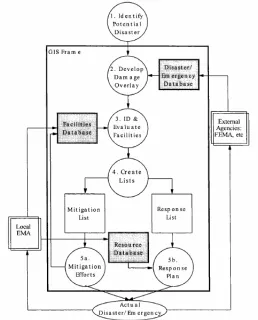
Kovel Disaster Database Model
Jacob Kovel of the University of Kansas has proposed a model for a database of information needed before, during, and after a disaster (Kovel, 2000). Kovel’s database consists of three parts; a key facilities database, a resources database, and a disaster and emergency database. These three databases exist to assist a disaster management system to identify key facilities that need to be protected or evacuated, the resources (and their locations) available for response operations, and the extent of likely damage to the key facilities.
The key facilities database contains information about the facility type (hospital, city hall, school, etc.), facility location (street address and some universal geographical identifier like a set of coordinates), facility priority level, and a notes section of other pertinent information. The resources database includes the type of resource (dump truck, shelter), the amount of resources available (two trucks, 130 beds), the resource location (address and coordinates), a contact person, their phone number, and any additional pertinent notes. Local officials primarily create the facilities and resources databases.
In order for the three databases to be used to prepare for a disaster and respond to it, they must first be created. In most areas, the required information in the three databases is not initially organized so that it can be easily distributed, but is instead collected in an ad hoc manner when a disaster occurs (Kovel, 2000). After the databases have been completed, they can be employed to support planning and disaster response operations. Kovel has proposed a five-step analysis procedure for using the data in the three databases, shown in Figure 4 (Kovel, 2000). The five steps are outlined below.
1. Identify the disasters that will likely affect the area of concern.
2. Develop overlays that will determine the extent and magnitude of damage expected (using models such as HAZUS-MH to create extent of damage database). Choose a disaster magnitude to prepare for based on the area’s history.
3. Determine which facilities and systems will likely be affected and the extent of the impact (using facilities database items).
4. Divide the facilities into the mitigation and response lists.
5. Prepare a plan to address those facilities and systems (using the response resources database).
Figure 4. Role of the Three Disaster Databases in the Five Step Data Analysis Process
Southwestern Indiana Disaster Management System
The Southwestern Indiana Disaster Management System (SIDMS) proposes a method of integrating an IMS, disaster databases, and disaster models to allow a decision maker, such as a head of emergency management, to craft highly informed disaster planning and response assessments (Uddin, 2002). The multi-disaster phase SIDMS focuses on two major efforts: simulation, planning, mitigation, and response for disasters; and, improving community awareness and readiness for disasters.
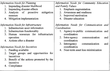
Five vital information needs, (planning, infrastructure, incentives, communications and coordination, community education, and family values) supply the information needed by the SIDMS and are shown in Table 3. Planning includes information about the likelihood and scope of potential disasters. Infrastructure includes information about telecommunications, electric power systems, gas and oil storage and transportation, water supply systems, emergency services, banking and finance, transportation, and continuity of government. The incentives
Table 3. Southwestern Indiana DMS Information Needs
The five information needs detailed in Table 3 feed a shared information repository, a common communication info-structure, and a decision support tool-kit in the SIDMS architecture shown in Figure 5 (Uddin, 2002). These five information needs are grouped together in a box in Figure 5. This box supplies information to the shared information repository, common communication info-structure, and decision support tool-kit in the SIDMS.
The shared information repository is a disaster database in an object-oriented or relational format that is connected securely to the other parts of the SIDMS architecture that request information from the repository. The common communication info-structure interacts with the communications from sensors in the field as well as voice and data communications between emergency management and first responders. The sensors in the field, surveys, and interactive communications between emergency management and first responders populate the data collection box that shares information with the common communication info-structure in Figure 5.
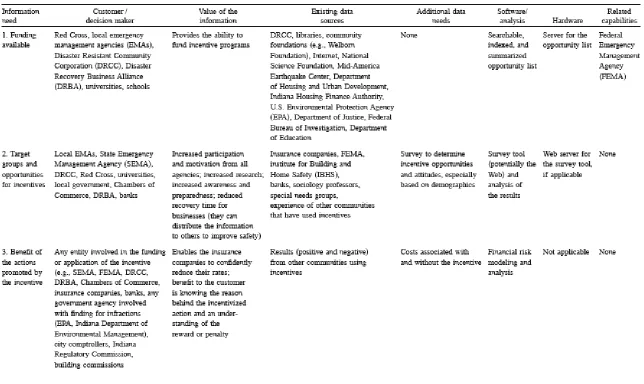
The five information needs outlined in Table 3 are similar to the list of HAZUS-MH data items in Appendix A. However, the difference between the two is that in the SIDMS, no specific data items have been specified. HAZUS-MH, on the other hand, fully specifies their data item set (by what data is actually included with the program). In Table 4, The SIDMS does outline available funding data resources for the incentives information need, but does not list specific data items related to this information need.
Table 4 lists existing data sources for the funding available, target groups and opportunities for incentives, and benefit of the actions promoted by the incentive portions of the incentives information need. The existing data sources listed are the locations where the desired data can be found, but the actual data sets owned by these data sources are not specified. Table 4 also lists the involved decision makers, the value of information, additional data needs, and software and hardware requirements. The authors of the SIDMS do not share data resources tables for the other four information needs listed in Table 3.
In terms of this disaster data study, the SIDMS proposed DMS architecture is informative because it articulates how a disaster data repository can interact with disaster simulation models and incident management communications. The SIDMS also identifies multi-disaster information needs and some data resources, although it does not identify any specific data items to include in a multi-disaster data repository.
Figure 5. Proposed Architecture for Southwestern Indiana Disaster Management System
Data Resources
Disaster data resources, often in the form of data repositories or databases, are needed to support disaster management systems and emergency management decisions. These data resources could have been compiled specifically to enhance disaster preparedness or for other reasons, often economic (loss amounts, inventories). Similarly, the data resource can be targeted for use with a single hazard type or it can be useful in responding to multiple disaster types. Appendix B lists just a sampling of the disaster data resources that exist, as well as information about disaster data resource directories organized by Texas A&M University and EQNet. The following paragraphs will describe the general categories of data resources.
Data resources can be divided into three categories of data resources available during and after a disaster. These categories are as follows:
1. Regularly collected raw information 2. Specifically collected raw information, and 3. Existing functional data from data providers.
Before a disaster, the regularly collected raw information (category 1) and the existing functional data from data providers (category 3) are available. The specifically collected raw information is collected only during and immediately after a disaster occurs.
The first category, regularly collected raw information, includes all raw information (unprocessed) that is regularly collected by organizations or instrumentation. One example of regularly collected raw information is most weather data, such as inches of rainfall or temperature. This information is generally collected by national, state, and local weather agencies. Seismic data collected as part of a regular monitoring program is another example of regularly collected raw information.
Specifically collected raw information includes all raw information that is collected only when there is a disaster. Any individual or organization that has an interest in the disaster’s impact collects this raw information. For example, data collection teams comprised of structural experts are deployed during a disaster to determine the extent of damage to structures in the affected area.
The third category, existing functional data from data providers, includes all raw information that was collected in the past and was converted into functional data when it was interpreted and placed into a database. One major data provider is government. For example, municipalities and counties are a resource for cadastral data, and the federal government is a resource for census data. Other data providers include private companies and research organizations.
CAMEO
Computer-Aided Management of Emergency Operations (CAMEO), is a system of software applications developed by the U.S. Environmental Protection Agency (EPA) that is used to plan for and respond to chemical emergencies (EPA, 2002). The software applications that comprise CAMEO include a chemical database, an air dispersion model, and a mapping capability. The chemical database includes over 6,000 hazardous chemicals and a search engine to access the data. Each chemical entry is linked to chemical-specific information on fire and explosive hazards, health hazards, firefighting techniques, cleanup procedures, and protective clothing. CAMEO also connects users with critical information to identify unknown substances during an incident. First responders, industry, environmental organizations, and emergency management professionals use CAMEO to access, store, and evaluate information critical for developing emergency plans (EPA, 2002).
The disaster type CAMEO is most likely to be used for is a hazardous materials spill in the United States (Table 2). From the perspective of the Kovel three disaster database structure, CAMEO would be included in the disaster/emergency database (Figure 4).
Florida Shelter and Road Status Databases
The Florida Division of Emergency Management (FDEM) on their citizen emergency information website provides a searchable real-time database of shelters and road status (FDEM, 2005). In the shelters database, users can select to view all shelters, all open shelters, all open special needs shelters, and shelter capacity by county. Each shelter entry contains information about shelter capacity, shelter occupancy, shelter status, the shelter’s storm surge category, the ability to house special needs individuals, and whether there are showers available on site. The road status database is similar in appearance and structure to the shelter database and lists road closures by county and whether the road has been re-opened yet. Each road closure entry lists the location of the closure, the road status, when it is estimated to re-open, the road condition, and detailed closure information.
The Florida shelter and road status databases can be used for many of the disaster types shown in Table 2. For example, these databases could be used for hurricane, earthquake, and flood disasters in Florida. From the perspective of the Kovel three disaster database structure, the Florida shelter and road status databases would be included in the facilities database (Figure 4).
Southern California Earthquake Data Center
DISASTER DATA RESEARCH BACKGROUND
This study and report focus on the topics of disaster data needs, resources, dissemination, and collection. One group that has done extensive work in the area of earthquake data collection is the Earthquake Engineering Research Institute (EERI), a nonprofit technical society of engineers and other earthquake researchers that works toward reducing the harmful effects of earthquakes through coordinated research. Also, more locally, the North Carolina Institute of Disaster Studies has held a series of workshops on coordinating disaster research between emergency management professionals and faculty within the University of North Carolina (UNC) System.
Earthquake Engineering Research Institute
In 2002, EERI held a workshop entitled An Action Plan to Develop Earthquake Damage and Loss Protocols to improve the collection and management of earthquake data (EERI, 2003). This workshop had similar goals to the workshop held at NCSU, including recommendations on how to improve data collection, support data access, and improve data organization and use. For improving data collection, the workshop participants recommended further defining earthquake data needs and a standardized data collection and storage format. Privacy and user access issues, as well as the development of agreements between the business and earthquake research communities, were participant recommendations for supporting data access. For improving data collection and use, the participants recommended establishing a data repository.
In addition to the recommendations developed at the 2002 EERI workshop, EERI has also developed standardized data collection forms for the different types of damage due to earthquakes. Reconnaissance teams, who travel immediately to the earthquake site, collect this data. The reconnaissance teams are formed by researchers completing a standard team member application on which they list their primary areas of expertise and travel preferences.
North Carolina Institute of Disaster Studies
The public University of North Carolina (UNC) system has sought to better coordinate the research efforts of its faculty and institutions with the efforts of emergency management professionals across the state and in local regions. The North Carolina Institute of Disaster Studies (NCIDS) was formed in 2001 by the UNC System based on a recommendation from the NC Disaster Response and Recovery Commission. This commission recommended that the UNC system should facilitate and expand the collaboration between academic researchers in the areas of disaster studies with emergency management professionals and first responding agencies in the state.
The mission of the NCIDS is the “creation of knowledge and transfer of practical intelligence that will mitigate against losses of life and property attributable to disasters of natural, technological, or terrorist origin.” To fulfill this mission, the NCIDS has three main purposes (NCIDS, 2004):
1) To facilitate and coordinate research relevant to disaster planning mitigation, response, and recovery;
3) To increase the flow of grant funds from federal, state, or private sources to disaster-related research and training.
Towards this mission, NCIDS held two workshops to identify agenda priorities for the Institute in accordance with their mission and goals. The first workshop, held in 2003 in Greenville, developed action items for NCIDS while the second workshop, which was held in 2004 in Charlotte, discussed public health issues and NCIDS research priorities.
Greenville NCIDS Workshop
The inaugural NCIDS workshop was held May 22-23, 2003 at East Carolina University in Greenville, NC with 78 emergency management professionals and academics in attendance. The goals of the workshop were to develop an agenda for NCIDS, identify the emergency management and homeland security needs of state and local government practitioners, and provide opportunities for collaboration between emergency management practitioners and the UNC university and community college system that would help to reduce the impact of natural and human-induced disasters on NC.
The workshop participants were divided into working groups led by a facilitator who used a common discussion format to lead each workgroup in identifying agenda priorities for NCIDS. From these discussions, common themes, focus areas, and action items were identified. Table 5 lists the focus areas divided into three main program goal areas: Education and Training, Applied and Basic Research, and Communication and Outreach (NCIDS, 2004).
Table 5. NCIDS Focus Areas Identified at the 2003 Greenville Workshop Education and
Training
Applied and Basic Research
Communication and Outreach
Educating NC’s Future Emergency Managers
NC Hazards Research Inventory
Develop a Comprehensive Hazards Communication Program for NC
Offer Continuing
Education for Emergency Managers
Coordinated and Sustained Applied Research Program
Coordinate and Utilize Existing Outreach Networks
Develop a Continuing Education Program for Elected Officials in NC
Support Needed Basic Research Initiatives
Develop a K-12 Hazards Curriculum and Teaching Resources
Regional Hazards Research – Quick Response Teams
NC Repository for Hazards Data and Information
Support for Multidisciplinary Research
Charlotte NCIDS Workshop
Carolina-private sector representatives in attendance. The goals of this workshop were to discuss public health issues as related to disasters and to extend the work of the first workshop in identifying research, funding, and collaboration priorities for NCIDS and the UNC System.
The workshop participants were divided into three breakout groups, one for each of the program goal areas identified in the 2003 Greenville workshop. The group facilitators led a discussion in each of the groups on developing an action plan and a funding strategy for NCIDS in the context of the program goal area for each breakout group. The results of each breakout group’s discussions were then presented to the entire workshop group by the breakout group’s facilitator. The Education and Training group identified key issues in their program goal area, including the balance between a focus on emergency response and prevention, surge capacity versus availability, a lack of agricultural and mental health focus, as well as community involvement and a need for expertise at wide levels. The Applied and Basic Research breakout group decided that the process of determining research priorities must be inclusive of all stakeholders and that strategies for addressing organizational challenges must be considered. The Communication and Outreach group determined that developing a NC repository for hazards data and information would be the focus area that would be of highest value and most achievable by NCIDS and that NCIDS should look into holding a forum to discuss the lessons learned from NC disaster responses and to discuss areas in which academics in the UNC system can contribute research (NCIDS, 2004).
North Carolina Emergency Management Division
The North Carolina Emergency Management Division in the North Carolina Department of Crime Control and Public Safety (NCEM) is the state agency responsible for protecting NC from the effects of natural and man-made disasters. Their mission is to enhance the quality of life in NC by assisting people to effectively prepare for, respond to, recover from, and mitigate against all hazards and disasters.
As part of their disaster preparation, mitigation, and response efforts, NCEM needs to be able to collect data about the impacts of a disaster in an organized manner so this data can be utilized in the future for prevention and mitigation efforts. Currently, NCEM receives data from disparate local, state, and federal groups that varies in format and quality. NCEM has a great interest in tapping the expertise of the University of North Carolina system academic community to help NCEM, not only by conducting disaster research but also by fielding data collection teams of faculty and students that could be quickly deployed after a disaster event to collect critical data on the disaster impact. These data collection teams need to be organized in their deployment, data collection, and data dissemination procedures in order for their efforts to be of maximum benefit to NCEM and the greater hazards and disaster community.
North Carolina State University
system is called DIsaster Operations, Risk, Abatement, and MAnagement (DIORAMA). DIORAMA is a computer system that helps to manage critical data regarding aspects of the built environment in relation to a disaster event (Pradhan, 2003). The prototype DIORAMA system constructed at NCSU was designed to fully accommodate the multi-phase and multi-event nature of what occurs during a disaster. The prototype DIORAMA system combines GIS with a relational database, photographs, computer-aided design (CAD) drawings, and site reports (Pradhan, 2003).
Within the NCSU DIORAMA system there is a cogent data framework (CDF) that stores and analyses the baseline and damage infrastructure information for multiple disaster events. This framework supports multiple users, facilitates information sharing, secures critical data against unauthorized access, and supports sophisticated spatial queries. For the framework to be considered a cogent framework, it must accommodate a digital depiction of the physical environment, integration of data sets into a single repository, connection of infrastructure features with their attributes, and evolution of the data set over time (Laefer, 2006).
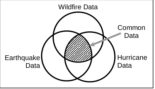
In order to define a cogent data framework, the disaster data needs and resources available for the framework had to be defined, as well as the ways in which disaster data was disseminated between groups involved in the disaster phases. Because the cogent data framework for DIORAMA has to include multiple disasters, the NCSU research focused on finding commonalties in data needs, or a common data set that could comprise the initial CDF for the prototype DIORAMA system (Laefer, 2006). Although disaster events are highly distinct in their nature, intensity, location, and timing, many share commonalties related to the data sets required to address these disasters in a multi-phase, multi-event context.
Figure 6. Illustration of Common Data Sets
Case for 2004 NCSU Disaster Data Workshop
Based on the data collection and dissemination issues raised by NCIDS, NCSU, and NCEM, it was determined that there was a need to gather members of the academic and emergency management communities together to obtain a more accurate picture of multi-disaster data collection, and to develop the foundation of a consensus on areas of disaster data management that needed improvement in NC. A workshop, instead of a series of meetings with individuals or groups, was chosen as the best way to address the data collection and dissemination issues. Within the workshop it was felt that there could be dialogue not only between the interested parties and the emergency management community, but also within the academic and emergency management communities.
In order to facilitate the development in NC of a disaster data management plan, NCSU offered to host a workshop comprising local public and private disaster management professionals, state and national experts, and academics on November 4-5, 2004 in Raleigh, NC. At this workshop, strategies for better data collection, data sharing, data dissemination, and pre-disaster coordination of disaster response teams for the Triangle region would be developed. It was hoped that the structure and results of the workshop would serve as a model for other local communities to develop better disaster data management plans. The workshop was envisioned to serve as a guide for other states and the federal government and as a possible tool to use to encourage better disaster preparation and management nationwide.
In the spring of 2004 a planning committee for the workshop containing members of NCSU, NCIDS, and NCEM, was formed to plan the workshop. The members of the workshop planning committee are listed in Appendix C. The workshop planning committee outlined the scope and objectives of the workshop, (listed in the following section) as well as the workshop agenda and speakers. The committee also sent out a letter of invitation, included in Appendix D, to encourage NC emergency management professionals and disaster researchers to attend.
Earthquake Data
Hurricane Data Wildfire Data