The
Future
Of
The
Currituck
Outer
Banks
One of the most controversial natural
resource management issues in North Carolina
over the past ten years has been the debate
sur-rounding the future of the Currituck Outer
Banks. As one of the last remaining undeveloped
and privately owned barrier island stretches on
the East Coast, this debate has taken on national
significance. Unlike many similar controversies,
planners have played a central role in this
debate, and a comprehensive planning philosophy
is being followed to determine the outcome. The
resolution of this issue has not come about in
traditional ways
—
there was neither a pitchedbattle between environmentalists and developers .
nor an invisible decision by government
bureau-crats. Rather, it was a test of the state's
new comprehensive coastal management process.
Some important lessons regarding the role of
planners and government decision-making on
com-plex resource management issues can be learned
from this experience. The future of the
Curri-tuck Banks, which will not be finally determined
for several more years, lies in how well these
lessons have been learned and applied.
THE
SETTING
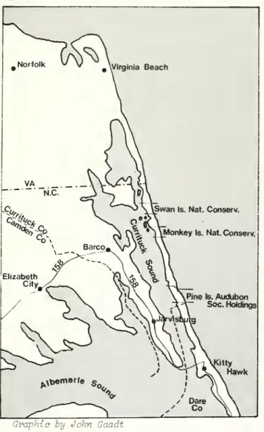
The Currituck Outer Banks is a long, narrow
sand spit in the extreme northeastern corner of
North Carolina. The Banks are about
twenty-three miles long, extending from the Virginia
border south to the site of the former Caffey's
Inlet, now the Currituck County border with
Dare County. The Banks are only 2,000 feet
wide at some points and two miles across at
the widest point.
The Banks have a typical east coast
bar-rier island profile -- ocean beaches, low
front-al dunes and hummocks, secondary dunes and sand
flats, large migrating back dunes, maritime
for-ests in the wider sections, and extensive
marshes on the sound side (Goldsmith, 1977)
Being at the transition point between
nor-thern and southern vegetation groups, the Banks
have an interesting and complex vegetative
cover. There are over 200 different species of
plants, some at their northern extreme (sea
oats), others at their southern extreme
(bay-berry and American beach grass). There are at
least ten species of endangered or unusual
plants and animals found on the Banks, including
loggerhead turtles, bald eagles, and Peregrine
falcons (Hosier and Cleary, 1979; U.S. Fish and
Wildl ife, 1980: 82-109)
There have been several wide but shallow
inlets on the Banks, at times making this a
true island (Stick, 1958: 1-10). In fact,
Cur-rituck Inlet set the boundary between Virginia
and North Carolina in 1663. However, the last
inlet, New Currituck, began filling in the late
1700s and closed completely in 1828. Prior to
this, the Currituck Sound, the wide, shallow
body of water between the Banks and the mainland,
had high salinity and large shellfishing beds.
With the closing of the inlet, and the diversion
of water-flows out of the Currituck Sound, the
Sound rapidly became almost fresh water in the
1800s, and now has a low salinity percentage.
The Currituck Banks have been inhabited
since at least the 1650s. While there were no
known Indian villages on the Banks, there is an
Indian burial ground on Monkey Island in
Curri-tuck Sound. Several small fishing and farming
villages were established on the Banks in the
1800s -- Wash Woods, Pennys Hill, Corolla, and
others. An additional source of income for
residents was provided by the U.S. Lifesaving
Service. Following several disastrous
ship-wrecks, the Service in the mid-l870s established
five lifesaving stations along the Currituck
Banks and completed the 156-foot tall Currituck
Lighthouse in the village of Corolla in 1875
A peak in use of the Banks came in the late
1800s and early 1900s with commercial fishing
and hunting and the growing popularity of
hunt-ing clubs. Starting with the establishment of
the Currituck Shooting Club in 1857 large tracts
of land were assembled to provide waterfowl
hunting areas for the wealthy club members.
Several of the clubs established beautiful
club-houses, with the Whalehead Club in Corolla being
particularly noteworthy. These large holdings
(e.g., the Pine Island Club owned four miles
of the Banks, ocean to sound) remained intact
until the 1960s and played a key role in deciding
the future of the Currituck Banks. The last
major period of settlement came during World War
II, when an influx of servicemen swelled the
population of Corolla to over 300. After the
war, population declined steadily until the
1970s. There are now only approximately fifty
permanent residents on the Banks.
David Cwens is Assistant Director, N.C. Office
of Coastal Management. He received his law
degree and M.R.P. from UNC-CH. Prior to
work-ing with the N.C. coastal program he was
coun-sel and senior planner with the Wisconsin
Office of State Planning and Energy.
#\Virginia Beach
Is.NatConserv.
MonkeyIs.Nat.Conserv.
PineIs.Audubon
Soc. Holdings
Kitty Hawk
Graphic by John Gaadt
Despite the closing of the inlets and the
proximity of the area to Norfolk, the Currituck
Banks have remained largely undeveloped, unlike
the beach areas of Virginia Beach to the north
and Kitty Hawk-Nags Head to the south. This is
primarily because there has never been an
im-proved public road to the Banks. Access from the
north was blocked when the U.S. Fish and Wildlife
Service bought the Back Bay National Wildlife
Refuge six miles north of the state line in
1938. The Wildlife Service has always resisted
construction of a road across this refuge. In
the 1970s the Wildlife Service halted access
even along the beach; they could do this legally
since they had purchased the beach-front down to
the mean low water line.l In fact, since
Janu-ary 1, 1980, only permanent Banks residents have
been allowed to drive along the beach through
the refuge. Public access from the south has
also been blocked. While a road to Corolla from
the south was shown on the state highway system
map from 1939 to 197^, no improved road was ever
const ructed.2 Developers closed off the
infor-mal trail that did exist in 1975. That action
was unsuccessfully challenged at the trial court
level but is still on appeal (West v. Slick,
75-SP-37 (Pasquotank Co., N.C. 1975)). A
pri-vate road for the exclusive use of landowners
and permanent residents was built by developers
in the mid-1970s, but it is closed to the
gener-al publ ic
.
FIRST ATTEMPT
ATPLANNING
THEFUTURE
The future of the Currituck Banks as a rel
atively undeveloped hunting preserve for the
wealthy few was challenged in the late 1960s.
Several of the hunt club tracts were sold to
developers, who began to lay out typical grid
subdivisions and to sell off small lots to
thousands of individual buyers.
Currituck Cou
sma1 lest and most
single incorporate
pared in 1970 to d
development. The
only rudimentary
water or sewer pla
pians -- in short
,
managing land deve
larly unprepared.
Area Management Ac
with its 1and use
coming on line on
nty, one of the state's
rural counties (without a
d village), was totally
unpre-eal with the impending massive
county had no land use plan,
and use ordinances, no public
ns, no open space or park
none of the modern tools for
lopment. The state was
simi-Passage of the state Coastal
t would not come until 197'*,
planning and permit programs
y in the late 1970s.
Still, the county and the state recognized
the developing problems and took forceful action
to deal with them. In the summer of 1972, the
county adopted a one-year moratorium on
subdivi-sion approvals and embarked upon a major
compre-hensive planning effort. The state agreed to
make Currituck County a pilot project for its
emerging coastal planning efforts. Governor
Bob Scott appointed an eleven-member
inter-departmental committee to work with the county
Bnd significant funds were secured to finance a
sophisticated planning effort.
The planning effort that followed in
1972-73 was widely hailed at the time as the model
for sensible resolution of coastal land
devel-opment problems. Since the county had no
pro-fessional planning capabilities, a planning and
design firm in Raleigh was hired to provide
technical planning services. This firm largely
designed the planning process and prepared all
the technical reports (Batchelor, 1973).
De-tailed papers were presented on the development
situation and potential.
The 1973 plan for the Banks included
sev-eral key features. First, the area was to be
developed as a destination beach. Therefore,
no north-south access was to be provided.
Access would be via ferry from the mainland.
Second, rather than grid-type development with
individual wells and septic tanks, development
The state endorsed these recommendations.
The secretaries of the Departments of
Adminis-tration, Natural and Economic Resources,
Trans-portation, and Human Resources all signed an
agreement in early 197** endorsing the basic
principles of the 1973 plan.
What happened is still the subject of
debate and confusion. The developers made an
offer of cash and land, which together they
valued at $1 million, to implement the ferry
system. However, the state was involved in
some major personnel shifts, including the
installation of a new secretary for the
Depart-ment of Transportation, which caused delays in
formulating a response. Jim Holshouser was
entering the final two years of his
governor-ship. As the only Republican governor of the
state in this century, and the last governor
without the power to succeed himself, his
abil-ity to hold matters together on this complex
and controversial issue began to slip. Some of
"THE
STATE AGREED TO MAKE
CURRITUCK
COUNTY
APILOT
PROJECT
FOR ITSEMERGING
COASTAL
PLANNING
EFFORTS."
^^
the developers, sensing changes in the
partici-pants' competitive positions, began to back away
from their earlier support of the comprehensive
plan. And the problem of securing the money to
implement key portions of the plan began to
appear insurmountable. The costs of
implementa-tion to state government were relatively high.
The estimate for a single ferry was $1 million
in initial costs and $250,000 a year in operating
expenses. The costs of acquiring a public park
in mid-county were in the $1.5 - $2 million
range. It soon became clear that in the face of
these considerable obstacles, the state would
not be able to fully carry out its part of the
plan.
For whatever reasons, the grand schemes of
1972-197^ collapsed. Public access, which was
probably the critical factor for support by the
county and the developers, was not provided and
a park was not acquired. The county, seeing the
access plans collapse, felt it could no longer
require developers to bear the high front-end
costs required for cluster development with
cen-tral water and sewer systems. So grid-type
sub-divisions with septic tanks were again approved
for the Banks. The 1973 Currituck Plan was
for the most part abandoned. Too much time had
been spent on design concepts and general notions
of proper development and too little time on
realistic appraisals of how the plan was to be
implemented. This plan met the fate of most
others -- it was briefly admired and then put on
the shelf.
In the years immediately following the
collapse of the first planning effort, two major
changes occurred on the Currituck Banks. First,
by early 1979 there were six major subdivisions
approved for the Banks. These contained over
five thousand individual lots and an additional
twenty-seven hundred townhouse units. About
four thousand of the lots had been sold by the
developers to individual purchasers, although
few of the lots had actually been developed.
There were less than two hundred structures,
many simply temporary fishing shacks and
trail-ers. Second, three large tracts had been set
aside for preservation. The Nature Conservancy
had acquired two of the old hunt club tracts in
the central and northern portions of the Banks
as nature preserves. The Monkey Island Club and
Swan Island Club tracts, over three miles of
ocean to sound property, were acquired by the
Nature Conservancy in late 1977 with a %k
mil-lion grant from the Mellon Foundation. In 1978,
the owner of the Pine Island Club property
donated half of the tract, the southernmost two
miles of the Currituck Banks, to the Audubon
Society for use as a sanctuary.
These two facts had important implications
for future planning efforts. First, given the
number of lots already sold, wholesale replatting
of the Banks would be virtually impossible. The
existence of the subdivisions would have to be
accepted as a given. Second, the Nature
Conser-vancy acquisition generally ruled out the
poss-ibility of any north-south thoroughfare along
the beach, something the county and state had
consistently opposed since the early 1970s.
A third very important change which would
greatly influence the second planning attempt
was that everyone had been through the
experi-ence once before. Developing a comprehensive
management program for the Currituck Banks was
no longer a novel experiment. While the
know-ledge gained the first time around would be
brought to the second effort, so too would all
the frustrations and resentments that result
from a failed pian.
The second planning effort got underway in
late 1978 with two critical catalysts -- a
renewed demand for public access and a new
pro-posal for a wildlife preserve.
The new push for improved publ ic access to
the Banks came from Currituck County officials
who wanted to diversify and broaden the
agricul-tural economic base of the county. Renewing a
tradition begun in the 1930s, the county board,
in 1978, asked the governor to provide access to
the area, preferably by bridge or ferry, but
lacking that, by road from the south". The new
and considerably more powerful governor was Jim
Hunt, a Democrat trom the eastern part of the
state. Governor Hunt was receptive to the
peti-tion and asked the Department of Transportation
to prepare a report for his action on the issue.
This renewed the Currituck Banks issues and the
interested parties -- the county, the developers,
the now land-owning conservation groups, and the
state agencies -- all began preparing to assure
the protection of their interests. It appeared
that the traditional development versus
conser-vation fight was about to ensue.
Just as everyone was gearing up to take on
the access issue, a second major issue emerged.
In early 1979, the U.S. Fish and Wildlife
Ser-vice announced that they were considering
pur-chase of all or part of the Banks as a new
na-tional wildlife refuge. This was not the first
time that the Department of the Interior had
ex-pressed interest in the area. The Back Bay
Na-tional Wildlife Refuge, six miles to the north,
had been established in 1938. The nation's
first National Seashore had been established at
Cape Hatteras, some thirty miles to the south,
in 1956. And in 196^+, Secretary of the Interior
Stewart Udall had suggested the idea of a
Curri-tuck Banks National Seashore, an idea that
received strong local opposition and a very
quick death.
This time the interests of the Department
of the Interior were generated by the demands of
the State of Virginia that something be done to
provide access to state parklands it had acquired
between the Back Bay refuge and the state line.
The Whalehead Club in Corolla was established
in the mid 19th century. Photo by Ellen Owens
This almost six-mi 1e-long stretch of beach,
False Cape State Park, had been acquired in the
late 1960s at a cost of some $8.3 million.
Des-pite a major study on providing access to this
area (Howard, Needles, Tammen and Bergdoff, 1977),
the Virginians had no way of getting people to
the park. Access across the sound posed many
environmental, financial, and practical problems,
and the Department of the Interior remained
ada-mant about forbidding a road through the Back
Bay refuge. In response to Virginia's pressures
for a road or a land swap, the Department of the
Interior decided to perform a comprehensive
anal-ysis of wildlife protection needs from the
Ches-apeake Bay to Dare County, N.C.
The first product of this study, an
environ-mental assessment laying out alternatives from
no action to total acquisition, became public in
March, 1979- The immediate response was loud
and negative. Within two months there were
press reports, generally accurate, of adamant
opposition to any federal acquisition whatsoever
on behalf of the county board, the governor,
the Congressman for the district, and both of the
state's Senators. The announcement of the Fish
and Wildlife Service's conclusions to an
unsus-pecting and unconsulted local and state
govern-ment very nearly led to the death of their
pro-posal .
However, this time the idea was not
summar-ily dismissed, as it had been in 1964 when
Stewart Udall proposed it. In early 1979, in
re-sponse to the access initiative, the state had
established a comprehensive planning framework
for addressing the future of the Currituck Banks.
The framework that was established in late
1978 and early 1979 evolved over several months
and incorporated the ideas of a number of people.
The central concept that developed was that there
needed to be a comprehensive, equitable,
imple-mentable resolution of all the critical issues
facing the Banks. This meant that all the key
issues
—
access, acquisition of naturepre-serves, the intensity and timing of development,
public services for development, and so forth
--needed to be addressed simultaneously. It meant
that all of the key parties and their interests
would have to be considered at every step of the
process
.
One of the factors that made this framework
viable in 1979, a factor that was missing in
1974, was the existence of a strong state coastal
management program. This gave the state a
standing policy-making group, the Coastal
Re-sources Commission, that would provide a forum
to start and maintain high-level discussion of
the issues. It also made available to the state
a core staff with the expertise and time to stay
on top of the myriad issues that make up these
complex resource management decisions. A number
of other factors were essential in making the
framework viable -- a strong governor interested
in the issue, cabinet secretaries willing to
re-government, courageous political leadership in
the county, and active participation of interest
groups at critical times.
CARRYING OUT
THE
SECOND
PLANNING
EFFORT
The second attempt at planning the future
of the Currituck Banks began in 1978 as the
first stages of the state Department of
Trans-portation (NCDOT) effort to provide access got
underway. Recognizing the importance and
com-plexity of the issue, state staff in the Office
of Coastal Management began to collect as much
information as possible on the Currituck Banks.
This involved collecting and reviewing reports
and studies, particularly those generated during
the first planning effort, meeting with state
and local officials involved in the earlier
plan-ning effort, and spending time on the Banks
be-coming familiar with the physical resources and
the existing development.
The next step in putting the plan together
was the formal establishment of a coordinating
body, a group that could provide policy guidance
in developing and implementing a state position
on these issues.
The group first took the form of a joint
committee with three members each from the
Coastal Resources Commission (CRC) , the Coastal
Resources Advisory Council (CRAC) , and the Marine
Science Council (MSC) . Staffing for the joint
committee was to be provided by the Office of
Coastal Management of the state Department of
Natural Resources and Community Development
(DNRCD) . The committee was established following
a joint meeting held between the three groups in
January, 1979, to discuss a variety of issues,
Currituck among them. The committee was
ini-tially formed to work with the county and NCDOT
on the access issue. However, within several
weeks of its creation, word of the acquisition
study by the U.S. Fish and Wildlife Service (FWS)
became public and the committee's charge was
informally expanded to address this issue too.
The first order of business was to acquaint
the committee with the full range of issues
fac-ing the Currituck Banks, so the first meeting
was held in Currituck County in February,
1979-It consisted of a field trip to the Banks
fol-lowed by a day-long meeting attended by all the
key parties interested in the issue. The county
board, the Fish and Wildlife Service, each of
the developers and major land-owners, each of
the conservation groups, and representatives of
the permanent residents presented their stories
to the committee. This served both to gather
essential facts and to acquaint the committee
with some of the underlying conflicts of values
and interests. The county laid out facts on tax
sition of a refuge. FWS laid out the history of
the acquisition and use of the Back Bay refuge,
the time-table for their study of wildlife
pro-tection needs in the general area (later to
become the acquisition proposal), and their
gen-eral policies of allowing only wildlife
activi-ties in refuges. Each of the two major
devel-opers presented detailed information on their
subdivisions (number of lots, lots sold,
num-ber of acres in open space, service provided,
etc.) and their respective conflicting positions
on the necessity of providing public utilities
and the desirability of public access. Not
surprisingly, the developer with a "clustered
subdivision" already having central water and
sewer and guaranteed access to the south
(Coastland Corporation) favored requiring
public utilities and opposed public access.
Similarly, the developer with five grid
sub-divisions having individual wells and septic
tanks and very limited guaranteed access
(Kab-ler and Riggs) opposed any requirement for
utilities and favored immediate provision of
public access. The latter point was
particu-larly important to both in that, based on a
cost-sharing agreement keyed to the number of
lots sold, Kabler and Riggs were paying 76 per
cent of the cost of maintaining the private
road to Corolla.
Photo by Ooraooke Photographer. Ann Ehrinahaus
The committee's second meeting was held in
April, 1979, with the top officials of NCDOT to
discuss their access planning process.
Repre-sentatives of both the county and environmental
groups were invited to attend. This meeting
served to educate all participants on the details
of the access alternatives and studies underway.
Later that spring, however, it appeared
that the framework for planning -- securing a
comprehensive, equitable, and feasible
resolu-tion of all the key issues concurrently -- was
going to break down before it had a chance to
get started. This possibility, which of course
remained throughout the planning effort, was
reflected in several events related to the
troduction of the acquisition proposal by the
FWS. In late March, the governor, while not
taking any formal position, publicly indicated
sympathy with local opposition to acquisition.
In April, the county indicated that it was
adamantly opposed to acquisition. Over three
hundred people attended a FWS meeting in the
county in early May, most expressing strong
opposition to the purchase. By late May,
fourteen members of the North Carolina and
Virginia Congressional delegation voiced
oppo-sition to purchase. In early June, the North
Carolina General Assembly passed a
reso-lution requesting a referendum in the county
before any federal acquisition would take place.
In sum, it looked like one of the major
poten-tial pieces of a comprehensive resolution of
the issue -- acquisition of some additional
part of the Banks to protect its natural
character -- would be rejected before it
could be seriously considered.
Also, in Apri1 , a seco
had been formed, a bi-state
the common concerns of Nort
ginia relative to Currituck
peared that a second commit
fragment a somewhat tenuous
situation, perhaps even com
CRC-CRAC-MSC committee for
issue. This proved to not
because there was a substan
membership of the two comm
i
staffed by the state Office
nd Currituck committee
committee to address
h Carol ina and Vi
r-It initially
ap-tee would further
ly held together
peting with the joint
turf on the Currituck
be the case, in part
tial overlap in the
ttees and both were
of Coastal Management.
Several factors were already at work behind
the scenes to prevent a breakdown of the
com-prehensive framework. First, and perhaps most
important, was the existence of the joint
commit-tee. This was a group of prominent coastal
policy makers urging a comprehensive resolution
and opposing precipitous decisions on any of the
individual issues, including acquisition of a
refuge. Second, since early 1979 the state
staff had been discussing with the county the
idea of performing a detailed fiscal analysis
of the Outer Banks development to determine to
what extent the projected tax revenues would be
offset by public service costs. In June, 1979,
the state made a special $6,000 grant to the
county to have the study done as the first step
in updating the county land use plan. Third,
given the clear opposition to their proposals
and a strong reprimand from the governor, the
FWS decided by early summer to work more closely
with the state and the county in future
develop-ment of their acquisition proposal. Finally,
several citizen groups had formed to provide
forceful public input into the process. One
such group, the Outer Banks Civic League, was
composed primarily of lot owners opposed to
acquisition and favored access. A second, the
Friends of Currituck, was composed of prominent
environmentalists and strongly urged a
compre-hensive resolution with careful study of each
option. The Friends of Currituck, co-chaired by
Currituck native Jerry Wright and former N.C.
State University Chancellor John Caldwell, p-layed
a very active role within North Carolina. The
close monitoring and day-to-day involvement by
the director of the group, Carrboro attorney
John Curry, was particularly important.
Several events in the summer of 1979 helped
to consolidate the comprehensive approach to
resolving the Currituck Banks issues. First,
the bi-state committee met in mid-June to tour
the area, convene a highly publicized meeting to
exchange views, and conduct a public meeting to
hear citizen opinions. This was important in
that it got a number of additional high-level
policy makers -- cabinet secretaries and state
legislators --personally involved and committed
to a comprehensive resolution. Second, the
joint committee met in July and adopted a set of
preliminary recommendations that were submitted
to the Governor. These recommendations were
that the scheduled December 31, 1979 terminatior
of all access along the Back Bay beach be
post-"...IN
RESPONSE
TO THEACCESS
INITIATIVE,
THE
STATE
HADESTABLISHED
AFRAMEWORK
FOR
ADDRESSING
THEFUTURE
OF THECURRITUCK BANKS."
poned pending a comprehensive resolution of the
Currituck Banks issues; that a final decision on
FWS acquisition be delayed to coordinate it with
the county land use plan update and other key
parts of the planning effort; that an
east-west access be the preferred access route, any
road from the south being only a tempor ry
access; and a full economic, engineering, and
environmental study of the access alternatives
be immediately undertaken by NCDOT. This action,
apart from the substance of the recommendations,
was important in two respects. It enhanced the
committee's credibility with all parties by
evidencing their willingness to take a stand and
communicate with the Governor, and it put the
committee firmly behind the concept of a
compre-hensive resolution. The bi-state committee,
meeting later in July, generally endorsed these
recommendations
.
The most serious c
hensive framework for re
of 1979, when the NCDOT
mend that the Board of T
iately resolve the acces
a public road to Corolla
environmental impact sta
access to the Banks, the
factor in determining it
be handled as just anoth
This proposed recommenda
on the staff's perceptio
still wanted the quick a
requested in 1978. The
al was quick and effecti
hallenge to the
compre-solution arose in August
staff proposed to
recom-ransportation
immed-s issue by establishing
without first doing an
tement. It appeared that
single most important
s development, would
er routine road decision,
tion was largely based
n that the Governor
nswer on access he had
reaction to this
commit-the Friends of Currituck, the Audubon Society,
and other environmental groups undertook a
major letter-writing campaign to the Governor
requesting an environmental impact statement
prior to an access decision. The Governor and
NCDOT staff got the message. On September 14,
1979, the Board of Transportation accepted a
staff recommendation to authorize a full impact
statement on access to the Currituck Banks and
to postpone a decision on access until after
receiving that report in late 1980 or early 1981.
This was a critical decision. If the state had
proceeded immediately with the road, the
compre-hensive framework might well have collapsed,
leaving the Currituck plan on paper with the
development decision made as a low-visibility
public investment choice.
The county's fiscal impact analysis was
completed in October, 1979 and had a major
im-pact on the county board's attitude towards
potential acquisition of a refuge. The report
(Roberts and Eichler Associates, Inc., 1979)
concluded that of the Outer Banks development
alternatives studies, one involving FWS
acqui-sition of the lands north of Corolla and
devel-opment of lands south of Corolla would be the
most advantageous to the county financially.
This confirmed what many had suspected -- that,
"THIS
REPORT
SUBSTANTIALLY REMOVED
ONE OF THE
COUNTY'S
PRINCIPAL OBJECTIONS
TO ACQUISITION,, THE
LOSS
OF TAXBASE..."
while substantial tax revenues would be generated,
the public costs of providing water, sewer,
po-lice, fire, and educational services would be
almost as high if not higher than the taxes
collected. Alternatively, if a refuge were
acquired, FWS would make payments in lieu of
taxes, thus providing some revenues, while the
public service costs would be minimal. This
report substantially removed one of the county's
principal objections to acquisition, the loss
of tax base, and created a climate wherein the
county could seriously consider endorsing
ac-quisition as part of a comprehensive resolution.
With this report and additional grants in hand,
the county in October began a comprehensive
updating of their land use plan.
Following a meeting with state and county
staff in November, 1979, the FWS agreed to
extend access permits along the Back Bay refuge
beach to permanent residents of the Currituck
Banks past the scheduled December 31
termina-tion date. While affecting a relatively small
number of people, this compromise by FWS on a
very emotional issue greatly contributed to
the cooperative spirit that was developing.
The first major element of a comprehensive
environmental impact statement (DEIS) on a
pro-posed refuge on the Currituck Banks was issued
by FWS in late December, 1979, with a comment
period running to April 1, 1980. The DEIS laid
out several detailed alternatives, with the
pre-ferred option being acquisition of all lands
north of Corolla and the wetlands south of
Corolla to the Dare County line. The DEIS
estimated the cost of this acquisition to be
on the order of $100 million, which would be
the most expensive single refuge expenditure
ever made by FWS.
The state's two committees on Currituck
met in mid-January to propose a merger into a
single Currituck Banks Advisory Committee (CBAC).
By combining membership, the committee would have
representatives of the CRC, CRAC, MSC, NCDOT,
DNRCD, Currituck County, and citizen members from
the county. The new committee agreed that its
role would be to provide policy advice and
coor-dination as to the state position on a
compre-hensive resolution of the Currituck Banks issues.
The review of the DEIS by the county and
the CBAC was quite detailed. It became clear
in discussions and in the public hearings that
were held in late February that there were
several key reservations regarding the proposal.
In the late 1970s development began in several
subdivisions on the Currituck Banks.
Photo by David Owens
There were concerns about the uncertainty of
payments in lieu of taxes, about continued
hunt-ing and fishing rights in waters adjacent to the
refuge, about the availability of beach
recrea-tion in the refuge, and about residents in the
acquisition area being treated fairly.
There-fore, the county and state staffs met with FWS
in early March to request additional
clarifi-cations on these concerns, resulting in a letter
to Governor Hunt in mid-March from FWS officials
in Washington, D.C., providing needed additional
information and assurances on key points.
After several months of careful work and
deliberation, the county and state took key
positions on the DEIS, the first piece of a
comprehensive resolution. As part of the local
land use planning effort, the county had
estab-lished a land use committee to work with
pro-fessional planning consultants (there still
being no in-house planner). The committee
re-viewed additional fiscal analyses and carefully
looked at the environmental and sociological
impacts of development on the Banks. The
com-mittee concluded that the county should
condi-tionally support acquisition. On March 17 the
Currituck County Board of Commissioners agreed
by a vote of three to one, to conditionally
en-dorse acquisition. The conditions of county
approval reflected the concerns noted above
and were conditions that, FWS had indicated in
their letter to the Governor,would be accepted.
On March 19, the CBAC, by a vote of ten to one,
recommended that the state similarly endorse
the proposed acquisition.
These positions reflected a compromise of
the parties involved as to an appropriate
fu-ture for the Currituck Banks. The northern
half would be preserved in its natural state
through acquisition as a new wildlife refuge.
The southern half would contain residential
development, with the wetlands acquired to
protect the Sound, and regulations enforced to
provide for oceanfront setbacks, dune
protec-tion, and appropriate septic systems. A public
recreation area would be provided at a
mid-point in the county to assure a buffer area
between development and the refuge and to
pro-vide guaranteed local beach access and use.
In the five months following these actions,
considerable state and county staff time was
spent making sure that FWS fully understood the
state and county concerns and would incorporate
them into the revised acquisition proposal, to
be issued as a final environmental impact
statement (FEIS). Tasks included keeping the
state Congressional delegation fully informed
of the progress of these discussions, as the
Congressman for the district and both Senators
had indicated they would support the state and
county's positions. The work was successful
in that the FEIS, issued August 28, 1980,
affirmatively addressed each of the
qualifica-tions raised by the state and the county.
Therefore, the CBAC and the county board
endorsed the proposed acquisition in September,
1980. The county board formally adopted their
updated land use plan, which incorporated
ap-proval of the acquisition proposal, in October.
The governor officially made the approval of
acquisition the state's position in November,
1980.
It is clear that the comprehensive
reso-lution that was the objective of this second
major planning effort has not yet been achieved,
much less implemented. The refuge acquisition
proposal still faces Congressional approval and
appropriations. Even with state and county
support, appropriations of this magnitude (as
much as $20 million per year for five years)
are difficult to obtain. Also, at Senator Jesse
Helms' request, the U.S. General Accounting
Office is performing a detailed audit of the
refuge proposal and negative comments by GAO
could affect funding prospects. The NCDOT
im-pact study on access alternatives, scheduled
for completion in early 1981, leaves the second
major issue unresolved -- securing adequate
public access to that portion of the Banks that
will be developed. The county land use plan,
which addresses the issues of density of
devel-opment, required services, beach access,
hurricane evacuation, and the like faces CRC
approval and local implementation. Still the
framework for a comprehensive, equitable, and
feasible resolution of the issues has been
firmly set in place and the initial results
are quite promising.
CONCLUSIONS
Determining the future of the Currituck
Outer Banks is the type of complex natural
resource management issue that is increasingly
facing planners and managers in the United
States. In order for these decisions to be
made in a rational and equitable fashion, the
past and on-going experience with the Currituck
Banks suggests several lessons. First, there
must be a degree of central management of the
decision-making process. In issues this complex
there Can never be central control of the entire
situation, but there must be someone to
coordi-nate and focus activities as much as possible.
The key actors who will influence or control
individual decisions must be identified and
involved. All the overlapping issues must be
identified and coordinated. Management of the
process, a role played by the Office of Coastal
Management on this issue, is an appropriate role
for planners. Second, critical information
necessary for informed decisions must be obtained
and presented to key decision-makers. The fiscal
impact study prepared for the county board is an
example of this. However, the planners providing
this information must recognize that it is
usually impossible to obtain all the information
fact to paralyze the decision-making process.
Also, the best information is worthless if it is
not available at the right time or is not
pre-sented in such a way that it can be understood.
Third, planners must recognize that these types
of issues involve basic governmental policy
choices, which are, almost by definition,
political choices. The planner who does not
recognize and deal with this can not
success-fully manage this type of planning process.
In this situation, choices on whether to
im-mediately proceed with the building of a road,
whether to oppose or cooperate with FWS, indeed,
whether to deal with the issues at all, were
ultimately made by politicians. Fourth, a
close tie must be maintained between the planning
concepts and the realities of practical
imple-mentation. There must be realistic appraisals
of the costs of implementation, of what is
politically acceptable, of the staff needs for
the planning process, of the long periods of
time needed to develop and carry out solutions,
and of the full range of points that influence
whether the decisions reached can be carried
out. In this case the comprehensive resolution
meets these tests, and it is recognized that
several additional years of work will be needed
to implement the choices made.
NOTES
'Access along the beach was first restricted in
1970. The restrictions were upheld in a federal
court challenge, Coupland v. Morton, Civil No.
1A5-73-W (E.D. Va., February 26, 1975).
^The North Carolina legislature has twice
enac-ted laws authorizing construction of a toll
turnpike along the Currituck Banks. The first,
passed in 19^8, was found unconstitutional as
an improper delegation of legislature authority
to the turnpike board. Carolina-Virginia Coastal
Highway v. Coastal Turnpike Authority 237 N.C.
52, Ik S.E.2d 310 (1953). The second, passed
in 1965, was upheld in the courts, North Carolina
Turnpike Authority v. Pine Island, Inc., 265
N.C. 109, 1^3 S.E.2d 319 (1965), but no serious
effort was made to build the road.
REFERENCES
Batchelor, Peter. 1973. "Interdisciplinary Team
Design and Planning for Coastal Management.
North Carolina Architect 20 (5,6) : 7-30.
Goldsmith, Victor, et al. 1977. Coastal
Processes and Resulting Forms of Sediment
accumulations
—
Currituck Spit,Virginia-North Carolina. Gloucester Point, Va.
Virginia Institute of Marine Science.
Hosier, P.E. and W.J. Cleary. 1979. An Analysis
of Selected Sites on Currituck Spit, N.C,
Raleigh: North Carolina Natural Heritage
Program.
Howard, Needles, Tammen and Bergendoff, Inc.
1975. False Cape State Park Transportation
Access Study. Richmond: prepared for the
Virginia Department of Conservation and
Economic Development, Division of Parks.
Roberts and Eichler Associates, Inc. 1979.
A Fiscal Impact Assessment of Development
on the Currituck Outer Banks. Currituck,
N.C. : prepared for the Currituck County
Board of Corrmissioners.
Soucie, Gary. 1976. "Fare-thee-well, Currituck
Banks." Audubon Magazine. 78 (1) : 22-35.
Stick, David. 1958. The Outer Banks of North
Carolina: 1584-1958. Chapel Hill: UNC Press.
U.S. Fish and Wildlife Service. 1980. Final
Environmental Impact Statement, Proposed
National Wildlife Refuge on the Currituck
Outer Banks. Newtown
Comer,
Mass. : issuedAugust 28, 1980.