B
Community
Character and
Scenic Resource
Study
COMMUNITY CHARACTER AND
SCENIC RESOURCE STUDY
3111 Manchester Avenue
Senior Housing Project
Cardiff by the Sea, California 92007 CASE NO.:17-273
June 2019
1
TABLE OF
CONTENTS
SECTION
PAGE
1.0 INTRODUCTION
………..…41.1
EXECUTIVE SUMMARY
………...41.2
PROJECT SUMMARY DESCRIPTION
………..…51.3
SUMMARY OF PUBLIC INVOLVEMENT/COMMUNITY PARTICIPATION PROGRAM
ACTIVITIES
………...71.3.1
Overview
………...71.3.2
CPP Meetings
……….…..72.0 EXISTING CONDITIONS
………...122.1
STUDY AREA
……….…122.1.1
Neighborhood Study Area
……….……122.1.2
Community Study Area
……….….122.2
SCENIC RESOURCES
………...………142.2.1
Public Scenic View Corridors
………143.0 PROPOSED PROJECT
……….163.1
BACKGROUND
……….…...…163.1.1
Existing Site Conditions
……….163.1.2
Operations
……….173.1.3
Staffing, Visitors and Guests
………....173.2
PROJECT DESCRIPTION
………183.2.1
Density
………183.2.2
Building Types and Architectural Style
……….183.2.3
Site Layout
……….183.2.4
Building Heights
………...193.2.5
Bulk and Mass
………...193.2.6
Streetscape
………213.2.7
Landscaping
………...…...213.2.8
Grading Plan Elements
………...213.2.9
Retaining and Free-Standing Walls and Fences
………..213.2.10
Parking
………...213.2.11
Public Improvements
………..213.2.12
Amenities
……….………...223.2.13
Non-Vehicular Mobility Features
………....223.2.14
Open Space
………....222
TABLE OF
CONTENTS
SECTION
PAGE
4.0
ARCHITECTURE
………244.1
DESIGN
………...….244.2
SURROUNDING ARCHITECTURE
………..284.3
GUIDELINES
………304.4
RESOURCE MANAGEMENT ELEMENT POLICY CONSISTENCY
…………...………..345.0 ANALYSIS
……….395.1
THRESHOLDS FOR EVALUATION
………..395.2
COMMUNITY CHARACTER ANALYSIS
………...………..405.2.1
Project Design
………..405.2.2
Study Area Features
………...………405.2.3
Community Landmarks
………...………. 415.3
SCENIC RESOURCES ANALYSIS………..415.3.1
Views from designated scenic highway/visual
corridor or vista points
………...425.3.2
Views through a designated scenic view corridor
……….425.3.3
Development of Natural Areas
………425.4
VIEW POINTS……….433
LIST OF
FIGURES
TABLES
APPENDICES
FIGURES
PAGE
Figure 1-1
Regional
Map………
6
Figure 1-2
Project Area
Map……….
.7
Figure 2-1
Study
Areas………
.12
Figure 2-2
Community Study
Area.……….
13
Figure 2-3
Visual Resource
Sensitivity………
..
………
15
Figure 3-1
Aerial View without
Project………
..
………
.16
Figure 3-2
Massing Study
………
..
………
20
Figure 3-3
Zoning
Map………..………
..
…………
..23
Figure 4-1
Aerial with Proposed Site Plan
………
..
…………..
25
Figure 4-2
Architectural
Styles………
..
………
26
Figure 4-3
Architectural Context………
..
……..
29
Figure 5-1
Key
Views………
..
…….
43
Figure 5-2
Existing/Proposed View Point Location
#1………
..
………
44
Figure 5-3
Existing/Proposed View Point Location
#2………
..
……
47
Figure 5-4
Existing/Proposed View Point Location
#3………
..
……
50
Figure 5-5
Existing/Proposed View Point Location
#4………
..
……
53
Figure 5-6
Site Plan
Layout………
..
……
56
TABLE
TABLE 4-1
Building Footprint………
..
………
....25
TABLE 4-2
Design
Guidelines……….…
30
TABLE 4-3
Resource Management
Element………
...35
APPENDIX
Appendix A
Cardiff-by-the Sea Community Character
Appendix B
Design Guidelines
Appendix C
General Plan Policy
4
1.0
INTRODUCTION
1.1
EXECUTIVE SUMMARY
The purpose of this Community Character and Scenic Resource Study is to evaluate the proposed development located at 3111 Manchester Avenue and its effect on community character, scenic resources and adopted land use/ design review policies. The analysis is intended to promote a well-designed development within the community, emphasizing design features that help maintain and enhance its character through architecture, landscaping and site planning.
The Neighborhood Study Area for the proposed project includes properties within approximately 850 feet of the project site boundary. The limits of the Neighborhood Study Area were determined in consultation with City of Encinitas staff. The neighborhood is characterized by open space and lower density single-family residential development to the north, Mira Costa College to the east, California Department of Transportation park-and-ride lot and related improvements associated with the Interstate 5/Manchester Avenue interchange to the west and the San Dieguito Lagoon Preserve to the south. Architectural styles within the Neighborhood study area are varied with both large and small buildings incorporating mixed setbacks, heights and building patterns.
The City of Encinitas is comprised of five distinctly unique communities. Each community possess an individuality that is a vital aspect to the overall character of the city. Architectural style, natural landforms, landscape palette and streetscape design are the primary criteria in determining its character. The combination of varied architecture, narrow streets with unimproved shoulders, pedestrian orientation and natural settings create an eclectic, small town feel that dominates the character of these communities. Cardiff-by-the-Sea is the community of focus in this study.
The analysis of the City Design Guidelines found that the proposed project is consistent with the intent set forth by the City. Through the use deep setback, projecting elements to break up wall plans, a mix of colors and materials and the use of appropriate scale the project respects the eclectic nature of the Cardiff community within the City of Encinitas.
The community of Cardiff-by-the-Sea encourages new development to respect and respond to the surrounding setting. The Community Character analysis found that the Manchester Senior Housing project has been designed to create a positive transition from undeveloped to developed land while respecting the character of the existing land uses. This is accomplished by maintaining consistency with the City Design Guidelines by integrating deep setbacks, projecting elements to break up wall plans, a mix of colors and materials and appropriate scale.
There are no community landmarks acknowledged on the project site. Thus, the analysis shows no adverse effect due to development of the proposed project.
The analysis of scenic resources found that though the proposed future development of this site would be visible from a designated scenic view corridor, it would not adversely impact scenic resources from Interstate 5 and the public viewpoints along Manchester Avenue because the architectural and landscape design would be complimentary to existing development and respect the natural topography of the site
5 and surrounding area.
The existing site area would be slightly altered with the introduction of the Manchester Senior Housing project, but the overall openness and low-scale character of the community would be preserved. The proposed project will be in harmony with the surrounding context by combining diverse architectural and landscape design elements.
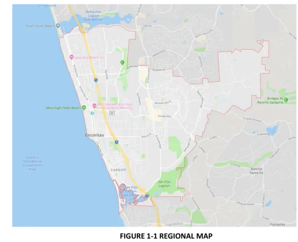
FIGURE 1-1 REGIONAL MAP
1.2
PROJECT SUMMARY DESCRIPTION
The Project is for Tentative Map Density Bonus, Planned Residential Development Permit, Major Use Permit, Design Review and Coastal Development Permit for a new, fully-licensed senior care facility and 8 single-family lots with each lot containing an accessory dwelling unit for a total of 16 *workforce affordable housing units located at 3111 Manchester Avenue in Cardiff-by-the-Sea. The project site is owned by the Yasuda Family and consists of two lots in a Rural Residential (RR)-2 zone. The site is also located within the California Coastal Appeal Jurisdiction, scenic/visual corridor and hillside/inland bluff overlay zone. The site totals approximately 19 gross acres. The California Department of Transportation (Caltrans) is in process of developing a new park-and-ride facility on an approximately 2.5-acre easement on the western edge of the site as part of the Interstate 5 North Coast Corridor Program Manchester Avenue interchange improvements. Proposed primary vehicular access to the site will be from Via Pico on the west side of the site north of Manchester Avenue. Secondary emergency vehicle access will be from Manchester Avenue at the southeast corner of the site. Vegetation consists of ruderal species around the perimeter with coastal sage scrub occurring along the north and northeastern border of the site.
6
The senior care facility is proposed to be two-stories in height and a third basement level and will accommodate a total of 200 units comprised of approximately 75 independent living units, 67 assisted living units and 58 memory care units (including both Circle of Friends** and a secured dementia wing of the facility). The size of the building is approximately 216,000 square feet with roughly 85,000 square feet of common area and 166 parking spaces. The building will be designed in an eclectic Craftsman style, incorporating wood siding and wood trim. The 16 workforce affordable units will have 17 parking stalls on the eastern side of the site. Greystar is proposing to dedicate approximately 6 acres of land to the north and east of the improvement area to the San Elijo Lagoon Conservancy for restoration and preservation as open space. All design aspects will adhere to the City of Encinitas’s Design Guidelines.
* “Workforce Affordable” or “Workforce Housing” (referenced throughout this application) refers to the affordable component of this project. These units will be dedicated for persons making between 50% and 100% of AMI and therefore qualify towards the City’s RHNA requirements. While these units are dedicated for any qualified person or household of the public, our goal is to potentially have some of the workers of the senior care facility live in these units.
** “Circle of Friends” is a proprietary program developed specifically for residents with
mild- to moderate cognitive impairment who are not elopement risks. Circle of Friends residents live in an unsecured portion of the facility but participate in their own unique program of care and activities designed to preserve and maintain cognitive function as they age.
7
1.3
SUMMARY OF PUBLIC INVOLVEMENT/COMMUNITY PARTICIPATION
PROGRAM ACTIVITIES
1.3.1 Overview
The City of Encinitas requires project applicants to create and implement a Citizen Participation Plan (CPP) early in the application process. The goal is to provide both the applicant and concerned citizens with adequate opportunities to discuss, understand and resolve issues related to potential impacts of the proposed project and surrounding area.
To encourage early participation by the public and create open dialogue between the applicant and neighbors, a CPP was prepared and provided to those who requested it. In addition, two CPP meetings were held with the community. The input received assisted the team in preparing a project design that meets project goals, reflects existing community character and addresses concerns raised by residents.
1.3.2 CPP Meetings Meeting #1:
Date: The first CPP meeting was held on December 11, 2017 at 6pm at the Encinitas City Hall located at 505 S. Vulcan in Encinitas
Attendees:
Representatives for the applicant included: • Bob LaFever, Greystar
• Beau Brand, Greystar • Jerry Brand, Greystar • Jordan Chase, Greystar
• Mark Faulkner, Consultant to Greystar • Joe Zink, Greystar
• Ted Youngs, VTBS
Meeting Summary:
A brief presentation of the proposed senior care facility was made by the development team and architect, including an outline of the Citizens Participation Program. After these initial remarks, there were several questions/comments regarding details of the proposed facility. These questions, comments and responses are as follows and are included herein to provide some context for decisions regarding site planning and building design:
1. What techniques did you use to notify and involve the public regarding your project? A neighborhood letter and vicinity map notifying all property owners and occupants within 850 feet of the project site was mailed on November 27th, 2017. The Cardiff Town Council, Cardiff Chamber of Commerce, California Coastal Commission San Diego Office, Encinitas Department of Development Services and San Elijo Lagoon Conservancy were also notified via a letter per the request of the
8
Planning & Building Department. Of the 37 notices mailed out, 5 were returned as undeliverable; 8 people attended the CPP meeting at the Carnation Room and signed-in.
2. What concerns, issues, and problems did you hear during the process? a. How will you address light pollution and noise pollution from the building? b. Why are you allowed to build this residential care facility in a residential zone? c. How will you address traffic caused by this project?
d. How will Greystar address the roof? Will there be A/C systems on the roof? e. Who will manage and operate this facility, are they legitimate?
f. Does the city really need another IL/AL/MC facility?
g. What is the timeline of this project? Does Greystar already have permits? h. How will Greystar address the fire risk associated with this project and its
operations?
i. Where will displaced animals and wildlife go with this project? j. Why will the project be one large building?
k. Regardless of the City’s direction, will Greystar perform an EIR?
l. How many beds will be licensed as an RCFE (Residential Care Facility for the Elderly)?
m. Is the wrap around parking too much?
3. How have you addressed the concerns, issues and problems raised above? a. Greystar will ensure that the design of this building orients lighting in such a way
to minimize any outward/unnecessary light pollution to its neighbors. Noise pollution is mitigated by having ample separation from the project facility to the most proximate houses on the hill. Greystar is proposing to leave the entire land area north of the building footprint as open space, providing such a buffer. Additionally, Greystar will adhere to City of Encinitas staff recommendations related to noise and light pollution.
b. The site is zoned as Rural Residential (RR-2) which allows for the development of a residential care facility with a Major Use Permit when a site is located on a prime arterial thoroughfare. Manchester Avenue is designated as a prime arterial thoroughfare.
c. Traffic impact and mitigation will be addressed through a traffic impact study that will be executed as a requirement for achieving entitlements. This traffic study will identify all traffic impacts of the proposed project and recommend ways for Greystar to mitigate such impacts. Greystar will follow recommendations of traffic impact professionals and City of Encinitas staff.
d. The roof element of the project will be largely determined by the prescribed Design Guidelines by the City of Encinitas. Current conceptual elevations include pitched rooves and ground-level A/C systems. All design elements at this point are conceptual and final design will be in strict adherence to the Design Guidelines. e. Greystar is in advanced negotiations with multiple reputable senior care operators
9
investment manager and property manager, Greystar takes the selection of a reputable/legitimate operator very seriously. As Greystar works through the development/entitlement process, an operator will be selected and identified to the City of Encinitas.
f. While the City of Encinitas has several senior care facilities, most of these facilities are over ten years old. Low vacancies at these existing facilities, coupled with an exponentially growing 75+ population in Encinitas indicate there is an undersupply of senior care units in the market. Additionally, per the current zoning code, there are almost no more feasible senior care sites to develop in the City of Encinitas. g. Greystar does not have any entitlements/permits related to the proposed project.
Greystar anticipates two to three years to attain the entitlements for this project, with an additional two years of construction once entitlements are attained. h. Fire risk is always a major concern for Greystar. Greystar met with City of Encinitas
staff on 9/20/2017, including the Fire Marshall Anita Pupping. Anita described all requirements, including 100ft setbacks from coastal sage brush. Greystar already took measures to ensure site plans followed the required setbacks, and Greystar will adhere to all additional requirements prescribed by the City of Encinitas related to fire safety. The building will be sprinkled, and all require state of the art fire suppression and warning technology will be designed into the construction. i. Greystar understands that the site, while currently being used as a commercial
farm, is largely open and free for animals to access. Greystar has proposed keeping all land to north and east of the building footprint (+/-6 acres), as open space to act as a wildlife and animal corridor. This corridor will provide uninterrupted access to and from the San Elijo Lagoon and the hillside to north of the project site. j. The current conceptual design of the project is one contiguous building because
Greystar holds the safety of its future residents in the highest regards. Senior care residents should not have to walk between two separate buildings to access common areas, including the bistro/restaurant. It is industry standard to have connected contiguous buildings to minimize the chance of an unnecessary fall. k. Greystar will provide an Environmental Impact Assessment (EIA) for review of the
City, and through CEQA review, will determine the level of environmental study that will be required for the project.
If there are concerns, issues and problems you can’t address, explain why?
l. Greystar cannot say how many beds will be licensed, as this depends on the senior care operator selected to manage the property. Once an operator is selected, Greystar will have a better idea as to how many units or beds will be licensed.
m. As part of the entitlement process with the City of Encinitas, Greystar will need to perform a parking study to understand how many total stalls will be needed per the intended use. Once this parking study is complete, Greystar will be able to more accurately address to parking needs/designs for the project.
10
The meeting lasted just over one hour. The attendees were informed that a report of the meeting would be prepared by the development team and architect and submitted to the Planning & Building Department. The report would include the questions and comments received and responses. Copies of the report would be mailed to the attendees once approved by the Planning & Building Department. The development team received no additional comments within the two weeks leading up to the meeting.
Meeting #2:
Date: The second CPP meeting was held on September 24, 2018 at 6pm at the Encinitas City Hall located at 505 S. Vulcan in Encinitas
Attendees:
Representative for the applicant included: • Jerry Brand, Greystar
• Beau Brand, Greystar
• Mark Faulkner, Consultant to Greystar • Joe Zink, Greystar
• Andy Gerber, Belmont Village • Ted Youngs, VTBS
• Melissa Krause, Latitude 33 Planning and Engineering Meeting Summary:
A brief presentation of the proposed senior care facility & workforce affordable housing was made by the development team, operator and architect, including an outline of the Citizens Participation Program. This was the second CPP meeting to be held for this project. After these initial remarks, there were several questions/comments regarding details of the proposed facility. These questions, comments and responses are as follows:
1. What techniques did you use to notify and involve the public regarding your project?
A neighborhood letter and vicinity map notifying all property owners and occupants within 850 feet of the project site was mailed on September 12th, 2018, and a notice was posted on the City of Encinitas website. The Cardiff Town Council, Cardiff Chamber of Commerce, California Coastal Commission San Diego Office, Encinitas Department of Development Services and San Elijo Lagoon Conservancy were also notified via a letter per the request of the Planning & Building Department. Of the 39 notices mailed out, 0 were returned as undeliverable; 1 person (Glen Johnson) attended the CPP meeting at the Carnation Room and signed-in.
2.What concerns, issues, and problems did you hear during the process? a.Concerned on traffic impact on Manchester Avenue, how will you manage this? b.Is Manchester Avenue a prime arterial road?
c.What AMI level will the workforce affordable housing units be for? Will these units count towards City RHNA requirements?
d.Will the workforce affordable units be deed restricted? e.What levels of care of will the senior facility provide?
11
3.How have you addressed the concerns, issues and problems raised?
a. At the request of the City, Greystar had a qualified consultant perform a traffic impact study for the project, which will be included in the project application. In addition to this study, Greystar has met with Caltrans to discuss how traffic flow will function on Manchester Avenue. Greystar adjusted their original design from their first application (03/2018) to take main vehicular access off the Caltrans spine road versus Manchester Avenue itself. The only vehicles now allowed to enter our site from Manchester Avenue would be for emergency vehicles. In addition to this change, there will be a right turn installed for the Caltrans spine road access.
b. Yes, Manchester Avenue is a designated prime arterial road.
c. The workforce affordable housing units are being proposed for 60% of AMI (low-
income) and will qualify towards City’s RHNA requirements.
d. Yes, these units will be deed-restricted for the public. Our goal is to also potentially have some of the workers from the senior care facility live in this units.
e.The senior care facility will provide Independent Living, Assisted Living and Memory Care units. These units will all be licensed and allow for “age-in-place” for our residents. 4.If there are concerns, issues and problems you can’t address, explain why?
None of the concerns, issues or problems couldn’t be addressed. Glen Johnson also indicated in the comments sheet that the presentation clearly identified the scope of the project.
The meeting lasted just over one hour. The attendee was informed that a report of the meeting would be prepared by the development team and architect and submitted to the Planning & Building Department. The report would include the questions and comments received and responses. Copies of the report would be mailed to the attendees once approved by the Planning & Building Department. The development team received no additional comments within the two weeks leading up to the meeting.
12
2.0
EXISTING CONDITIONS
This chapter describes existing conditions within the Neighborhood and Community study areas surrounding the proposed project. For this study, only views from public vantage points were evaluated. Information regarding existing conditions was gathered from numerous sources including City’s Resource Management Plan, Design Guidelines, zoning maps, Community Character Guidelines, site visits and photographs.
2.1
STUDY AREA
The community character and scenic resources analysis for the project includes the study of both a Neighborhood Study Area and Community Study Area. The Neighborhood Study Area includes area within 850 feet of the project site boundary. The Community Study Area encompasses a much larger area comprising a portion of the Cardiff-by-the-Sea community. These are summarized below and described in more detail in Appendix A.
2.1.1Neighborhood Study Area
The Neighborhood Study Area for the proposed project includes properties within approximately 850 feet of the project site boundary. The limits of the Neighborhood Study Area were determined in consultation with City of Encinitas staff. Existing uses in the Neighborhood Study Area include, open space, commercial uses, residential uses and institutional uses.
Figure 2-1 Study Areas illustrates the approximately 850’ radius map identified as the Neighborhood study area
2.1.2Community Study Area
The City of Encinitas is comprised of five communities, which are each described in the City’s General Plan Land Use Element. The proposed project’s study area is defined by
13
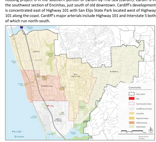
the designated community that the project is located within. The Manchester Senior housing project is in the southern portion of Cardiff-By-The-Sea (Cardiff). Cardiff is in
the southwest section of Encinitas, just south of old downtown. Cardiff’s development
is concentrated east of Highway 101 with San Elijo State Park located west of Highway
101 along the coast. Cardiff’s major arterials include Highway 101 and Interstate 5 both
of which run north-south.
Figure 2-2 Community Study Area illustrates the boundaries between Encinitas’ community character areas, identifying where changes in character occur
Currently there are five general community character areas that exist in Cardiff-by-the-
Sea. Each of Encinitas’ communities has unique land use characteristics that reflect its
history and sense of place: • Coastal Residential • Village Center
• Inland Residential-Gridded • Inland Residential-Curvilinear • Neighborhood Center
The character of the Manchester Avenue project site is considered Inland Residential-Curvilinear.
Inland Residential Curvilinear Community
The coastal communities, which includes Cardiff, have an eclectic and unique character and share similar development patterns. One of the major contributors to the eclectic style of the coastal communities is the variety of architectural styles. The existing buildings have generally taken elements from a specific architectural style but do not always follow one style consistently throughout the community. The mixture of styles
14
from lot to lot is what helps create the distinctive Cardiff -by-the-Sea style and character.
Inland Residential Curvilinear is a predominant community character within Encinitas and the portion of Cardiff the project site resides. Community characters are used to recognize the physical characteristics, including street layout, loot size, and building form and scale of an area. The Inland Residential Curvilinear character exists on the eastern portion of Cardiff and is suburban in character, with curvilinear streets and cul-de-sacs with larger homes set back from the street. The blocks are irregular and very large with long, curving streets that often terminate in cul-de-sacs. Continuous sidewalks and formal curbs are also present.
The context of the community includes mainly single-family residential subdivisions
developed in the late 1970’s through the mid 1990’s however commercial and
institutional used are also present. It is suburban in character, with curvilinear streets and cul-de-sacs with larger homes set back from the street.
Lot sizes in Cardiff community character area typically range between 4,000 and 15,000 square feet measuring 60-80 wide and 100-160 feet deep with varying orientation. Buildings typically face the street with parking accessed on-site from the street. Lot coverage ranges between 20-40%. Front setbacks typically vary from 10-30 feet, with side setbacks between 5-15 feet and rear 40-100 feet. Building height is primarily two stories ranging between 20-30 feet. Roof form is commonly hip and gables with entries generally facing the street.
Within this type of community, the following opportunities exist:
•Design projects with sensitive transitions respecting the existing low- scale residential form and character;
• Focus higher density housing close to arterials and activity centers; •Enhance active, outdoor lifestyle; and
•Enhance connectivity to services, transit, and open space/trails.
2.2
SCENIC RESOURCES
The City of Encinitas’ General Plan Resource Management Element describes the scenic resources within the vicinity of the project. The following narrative describes the scenic resources that could be affected by the implementation of the proposed project. 2.2.1Public Scenic View Corridors
The Resource Management Element included in the City’s General Plan designates Manchester Avenue and Interstate 5 as scenic view corridors. The corridor along Manchester extends just northwest of the intersection of El Camino Real and Manchester Avenue southeast of the intersection encompassing large portions of the San Elijo Lagoon. Interstate 5 viewshed is considered the area crossing San Elijo Lagoon.
15
Figures 2-3 Visual Resource Sensitivity refers to the location of these scenic roadways and scenic view corridors.
16
3.0
PROPOSED PROJECT
3.1
BACKGROUND
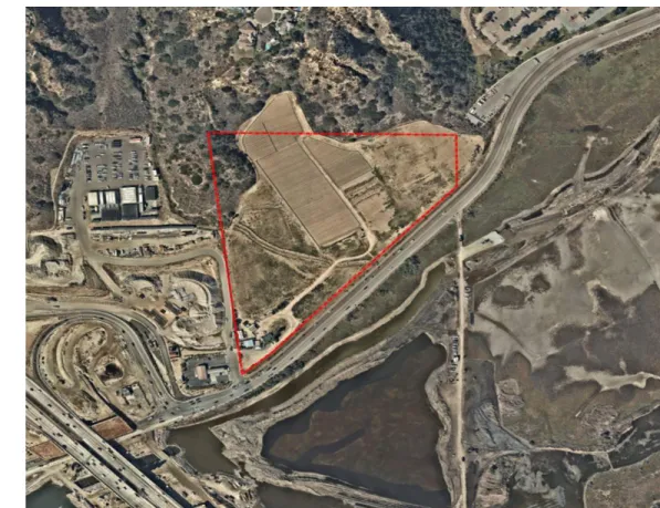
The Manchester Senior Housing project consists of 200 senior living units on approximately 19 acres, and is located at 3111 Manchester Avenue, east of interstate 5 in the Cardiff-by-the-Sea community. A Tentative Map Density Bonus, Planned Residential Development Permit, Major Use Permit, Design Review and Coastal Development Permit are required for the project.
3.1.1Existing Site Conditions
The project site is located along a two-lane local collector roadway, Manchester Avenue, just east of Interstate 5. Access to the project will be from Via Pico which is being improved as part of the Interstate 5/Manchester Avenue project being constructed by Caltrans. Emergency vehicles only will be allowed direct access to the site off Manchester Avenue via a secondary entrance located at the southeast corner.
The existing site land area is generally characterized by a mix of moderately slopes open terrain and steep vegetated coastal bluff. The total project area
is comprised of
approximately 14.43 aces and consists of two general topographic zones within the property. Most of the site consists of disturbed vacant land used for agricultural operations and the small remainder of the site is considered coastal bluffs.
Figure 3-1 Aerial View without Project
The overall property is sloped from the north to south with property elevations that range from approximately 158 to 8 across the site. The small coastal bluff area in the northwest corner of the property slopes from 158 to 37 and contains the highest point of the site. The north central coastal bluff area slopes from approximately 80 to 70. The larger centralized agricultural area which encompasses the majority of the site slopes from approximately 100 to 8.
The coastal bluff areas consist of primarily undisturbed native vegetation while the agricultural area is completely disturbed with various temporary crop rotations through that year as part of the agricultural operation. The site drains from north to south and surface flow drainage is collected in an existing drainage ditch that runs along the southern border of the site parallel to Manchester Boulevard. The site drainage is collected within the ditch and conveyed to the south side of the street with existing culverts beneath the street. The proposed development proposes limits of
17
grading at approximately 10.35 acres of the total site and the development area is located within existing disturbed agricultural area.
3.1.2Operations
Senior Care Operator: Belmont Village Senior Living
The proposed project will be a fully licensed residential care facility for the elderly (RCFE) regulated by the State of California Community Care Licensing Division of the Department of Social Services. All units in the project, including those designated as “independent living” will be licensed to provide care services to residents including assistance with daily needs and specialized care as needed. This enables us to provide care to residents who move into independent living units but subsequently need assistance without requiring them to move to another unit within the building. The facility will be exclusively for seniors 60 years of age or older, or seniors younger than 60 who have comparable care needs. However, the average age of residents is expected to be over 80 years old. Residents typically choose to live in this type of community instead of a private home because of a desire for a more social environment and the convenience of dining, activities and amenities available on-site or because they need assistance with daily activities.
Seniors reside at the facility as month-to-month tenants and enter into a Resident Services Agreement (RSA) which provides for the non-exclusive right to occupy a unit within the facility, three meals per day, entertainment, activities, amenities and transportation. Care services are also included in the RSA for assisted living and memory care residents. Since all units within the facility will be licensed, independent living residents may add care to their RSA without being required to move if at any time they develop the need for assistance.
Independent living units will be clustered together but not separated from assisted living units, and both independent living and assisted living residents share the common dining room as well as other common areas and amenity spaces throughout the project. Other common areas shared by independent living and assisted living residents include a private group dining room, an outdoor dining area, outdoor courtyard, therapy pool, beauty salon, bistro, movie screening room, computer room, library, flexible multi-purpose meeting room (a.k.a. “Town Hall”) as well as smaller, flexible gathering spaces. Activity programming is designed to be enjoyed by both independent living and assisted living residents together.
Memory care is required to be secured, and therefore memory care units are segregated from the rest of the project. The memory care wing includes its own dining room and other common areas for use by memory care residents. A secure outdoor courtyard is also included to provide safe outdoor space for memory care residents as required by the State of California for RCFE’s.
3.1.3Staffing, Visitors and Guests
All uses within the proposed project will operate 24 hours per day. However, most employees will be present during the “day shift” which typically runs from approximately 6:00 am to 2:00 pm. More limited rosters of employees will be present during the night shift (2:00 pm – 10:00 pm) and overnight shift (10:00 pm – 6:00 am). The facility will be staffed by approximately 100 full-time equivalent (FTE) employees. We anticipate approximately 41 employees during day shift, 30 employees during night
18
shift and 7 employees during overnight shift. Shift changes are deliberately scheduled during off-peak traffic hours to minimize our automobile trips during A.M. and P.M. peak hours. In addition to regular staff, some services such as operation of the beauty salon, hospice care and physical therapy may be provided on the premises by outside contractors and vendors.
Family and friends are permitted to visit 24 hours per day, though we try to encourage visiting between 9:00 am and 5:00 pm. We may also provide a night concierge to greet after hours visitors. Vendors and service providers are generally restricted to visiting between 9:00 am and 5:00 pm and are required to have an appointment to visit. Residents are permitted to have guests overnight and, depending on availability, we may provide a furnished apartment for short term stays by guests. All visitors, guests, vendors and service providers are required to check in upon arrival and may park in any available parking space. Residents who wish to park a vehicle onsite must have a
valid, current driver’s license and vehicle registration and must be active drivers (i.e.
no long-term vehicle storage is permitted).
3.2
PROJECT DESCRIPTION
The Manchester Senior housing project would be a licensed senior living facility consisting of independent living units, assisted living units, Circle of Friends units and memory care units. The project will also include 16 workforce housing units. Access to the project will be from Via Pico west of the site. Emergency vehicles will have secondary access off Manchester Avenue at the southeast corner of the site.
3.2.1Density
The Project is located on land designated as RR-2, Rural Residential zone. The site allows for lower density single-family residential developments with a maximum density of 2.0 units per net acre. The zone is intended to provide a transition from rural to more suburban areas within the City.
3.2.2Building Types and Architectural Style
Because this parcel has historically been in agricultural use, many aspects of the design relate back to the early agrarian roots of the Cardiff/Encinitas area. Board-and-batten siding, simple pitched roofs, gables with barge brackets, and detailed window surrounds are all elements found in a coastal agrarian design. These design elements and materials create visual interest and are compatible with the local architecture. The style of the workforce housing is a contemporary take on the coastal agrarian aesthetic, with clean lines and a varied color palette. Board-and-batten siding pitched roofs and simple forms are the foundations of this style. The eight houses are sited to form a central “village green” common space that encourages a sense of community within a larger community. The houses are also situated on stepped pads that respond to the sloped site and take advantage of views.
3.2.3Site Layout
The site layout is related to various opportunities and constraints of the site that determined the most appropriate overall site plan for the property. The development area was defined by the existing property lines, the City Zoning Code setbacks, existing easement constraints, the existing and proposed street right of way and improvements for Manchester, the proposed street right of way and improvements for the Caltrans DAR road, the FEMA flood zone line, the only allowable vehicular points of access from
19
the proposed DAR road, emergency vehicular access, pedestrian connections to the public system, site topography, earthwork, existing vegetation setbacks, and existing and proposed utility service to the property. The building placement, vehicular and pedestrian ingress, egress and path of travels, utility layout, and storm water / water quality management all played an equally important role in the final site layout. The vertical positioning of the building and site improvements were based upon FEMA flood zone elevations, vehicular and pedestrian access, existing and proposed site utility constraints, the site topography and earthwork; as well as on and off-site visual analysis considerations. The proposed site layout was determined to be the most appropriate solution for the development based on the building types, densities, and zoning requirements in relation to the site opportunities and constraints; resulting in a site plan that provides the best living experience for the residents while protecting the safety, health and welfare of the public.
3.2.4 Building Heights
The proposed project will include both one-story and two-story elements with a finished height of 30’.
To provide visual openness and pedestrian scale along Manchester Avenue, heights of buildings or portions of buildings will be generally lower when adjacent to the street corridor, stepping up to higher elements further from the corridor. Low roof elements, such as porches and building projections have been added to the senior building composition. The proposed project complies with the underlying zoning.
3.2.5Bulk and Mass
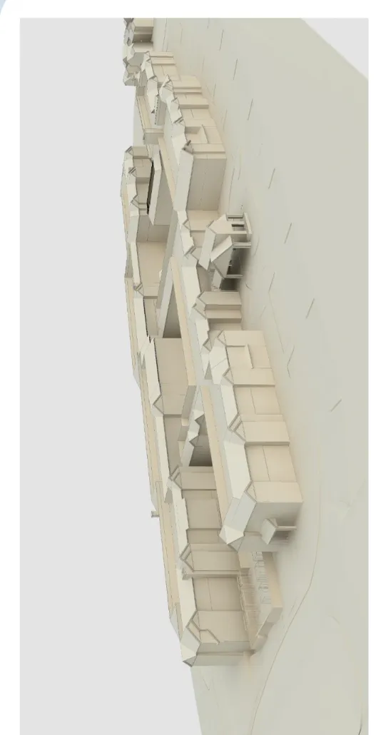
The project’s facade treatments and simple roof gabled roof forms are intended to reflect the existing agrarian nature of the site and the history of Encinitas. Massing is enhanced by varied roof elements and materials such as siding, stucco and stone tile. Staggered façades and projecting wings will allow for a play of light and shadow on the buildings. Lower, smaller scale elements have been added to enhance the human scale of the project. Light to medium colors and materials will reinforce the agrarian theme and reduce the building mass
A massing study was conducted to properly characterize the proposed building envelopes relative to the site. Figure 3-2 depicts an aerial view of the building massing.
20
Fig
u
re
3
-2
Ma
ss
in
g S
tu
d
y
il
lu
strate
s
the
m
ass
o
f t
h
e
b
u
ild
in
21 3.2.6Streetscape
Manchester Avenue is a two-lane roadway with a posted speed of 45 mph. The project will shift the existing striping north within the existing right of way to accommodate installation of curb/gutter and a decomposed granite trail segment on the south side of Manchester Avenue. Sidewalks are in place along the north side of Manchester Avenue; however, the project will improve the public area along the property frontage with the construction of standard curb, gutter, non-contiguous sidewalk and landscaping.
3.2.7Landscaping
The proposed landscaping will consist of non-invasive, drought tolerant native plant material that comply with the San Elijo Conservancy Coastal Sage Shrub Plant Field Guide. The enhanced paving at the entry points throughout the project as well as turf block will be provided in the fire lane to mitigate the expanses of paving. Additionally, appropriately sized trees will be planted within the parkway for screening purposes. 3.2.8Grading Plan Elements
The site will include manufactured graded slopes with slopes 2:1 or less. There is expected to be a large back cut slope at the rear of property to daylight the developed pad to the existing site topography. Grading design also includes top of slope brow ditch and toe of slope v-ditch drainage systems. There is a typical 2:1 max graded slope between site pad elevation changes.
3.2.9 Retaining and Free-Standing Walls and Fences
The site will include small retaining walls to allow for specific landscape improvements. Private yard wall/fencing is included around the workforce unit lots as specified in the landscape architecture drawings. Storm drain headwalls at inlet/outlet structures are proposed with the possibility for fencing around detention basins if required for safety. 3.2.10Parking
Surface parking will include accessible parking stalls as required, with appropriate signage, striping, markings and wheel stops. Landscape elements, such as trees and shrubs will be added to screen the parking areas with landscaping installed every six to seven stalls along the building frontage. Additionally, the frontage along Manchester is designed to screen the parking from the street per the City’s design guidelines. 3.2.11Public Improvements
The project will provide public improvements along the property frontage of Manchester Avenue. Improvements shall include the removal of the existing AC berm and the construction of standard curb, gutter and non-contiguous sidewalk on the north side of Manchester Avenue. As referenced, an emergency entrance driveway will be provided at the southeast corner of the site off Manchester Avenue along with two public driveway connections from Via Pico. The existing ditch within the right-of-way will be filled in and replaced with storm drain if necessary. A decomposed granite (DG) path will be constructed along the south side of Manchester Avenue generally beginning at Via Pico and extending along the site frontage. The trail would be installed in the existing disturbed road right of way connecting to a proposed Caltrans trail west of the site. The City of Encinitas would connect a future trail segment to the east end
22
of the trail. Manchester Avenue would be restriped in the existing disturbed right of way to shift traveled lanes approximately 8 feet north. This would accommodate all anticipated trail and pedestrian infrastructure improvements.
Private improvements will include streets and drives including pavement, curb and gutter, emergency access lanes including gated access, pavement, curb and gutter and turf block.
3.2.12Amenities
The project will include several private amenities such as a pool and spa with both sunning and shaded lounge areas, an entertainment terrace, dining pavilion, fountain garden with patio and large open lawns to allow outdoor activities and community events. It will include a meandering walking path that has direct connections to the private patios.
3.2.13Non-Vehicular Mobility Features
Paved pedestrian walks and paths that provide an interior path of travel around the entire building and to all the building entrances and site amenities is included in the proposed project design. There will be pedestrian connections to public walk at Via Pico as well as pedestrian parkway concrete walk along the north and south sides of Manchester as described above. ADA accessible path of travel will be included as required by City standards.
3.2.14Open Space
The project will provide a minimum of 40% of the site area as designated Open Space. The project will dedicate approximately 6 acres to the San Dieguito Lagoon conservancy with the intent that the acreage be designated open space.
The open space area north of the development area will contain vegetation, trails, and other passive landscape amenities. A minimum of 365 square feet for each affordable unit will be required open space that can be either active or passive with an average slope of 15% or less.
3.2.15Land Use
The proposed project is located on a site that has been previously disturbed for agricultural purposes and is free of any significant landscaping features. The zoning for residential uses in Cardiff is comparable to that of other communities in Encinitas in that housing densities remain higher along the coast of the city. Eastern Cardiff is considerably more rural with some commercial uses that are located along Highway 101 and the offramp of Interstate 5 at Manchester Avenue. Park and recreation uses are located in proximity to the project site.
The Project is located on land designated RR-2. The RR-2 designation permits Residential Care as a use with approval of a Major Use Permit.
The site is bounded by single-family residences to the north, Interstate 5 to the west, and San Elijo Lagoon open space preserve to the south. The zones that immediately surround the site are designated Residential 3 (R-3, max density of 3 units per acre) to the north, Open Space (OS) to the south and Public/Semi-Public (P/SP) to the east. Adjacent and immediately north to the proposed site exists a single-family residential development that permits a
23
minimum lot size of 14,500 square feet and a maximum density of 3.0 units per net acre which services as a transition from rural to suburban. The P/SP zone to the east of the project site permits activities operated by the City, County or other governmental agencies such as fire, school, water, or sewer districts. Semipublic uses such as hospitals and other private institutions may be included. Also included as part of the Neighborhood Study Area is the San Elijo Lagoon open space in the OS zone immediately south of the project site and Manchester Avenue.
Figure 3-3 Zoning Map delineates the zoning designation of the site and surrounding area.
24
4.0 ARCHITECTURE
4.1
DESIGN
The Manchester Senior Project has been designed to harmonize with the unique site characteristics. Because the parcel has historically been used for agricultural purposes
many aspects of the building’s design language relate back to the early agrarian roots
of the Cardiff/Encinitas area. Design elements include board-and-batten siding, simple pitched roofs, gables with barge brackets and detailed window surrounds, which are elements found in this restrained coastal agrarian aesthetic. Stone siding serves to not only anchor the building to the ground, but also provide visual consistency with the adjacent rocky hillsides. These design elements and materials create visual interest and are compatible with the local architecture. The overall massing of the proposed building also reinforces the agrarian theme with projecting low-scale wings, a varied yet simple roofline and a myriad of smaller scale features like porches and trellises. Additionally, the massing complements the site by stepping up the hillside rather than dominating the site as one single mass.
The Manchester Workforce Housing project provides a unique design treatment for each of the eight proposed residential structures. The style is a contemporary design based on the coastal agrarian aesthetic incorporating clean lines and a few hints of bold color.
The design guidelines characterize Encinitas as having an eclectic architectural nature. The residential design enhances that notion. Board-and-batten siding, pitched roofs, simple forms and a use of color are the foundations of the design. The site planning and massing of the project further relate these houses back to the community context and site characteristics. The eight structures are sited to form a central “village green” common space that encourages a sense of community within a larger community. The houses are also situated on stepped pads that respond to the sloped site and take advantage of views.
25
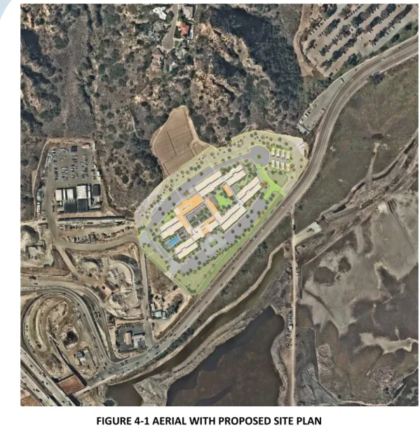
FIGURE 4-1 AERIAL WITH PROPOSED SITE PLAN
TABLE 4-1 BUILDING FOOTPRINT
UNIT TYPE # UNITS AVERAGE UNIT SIZE Independent Living 75 Units 829 sf.
Assisted Living 67 Units 657 sf.
Circle of Friends 30 Units 459 sf.
Memory Care 28 Units 404 sf.
26
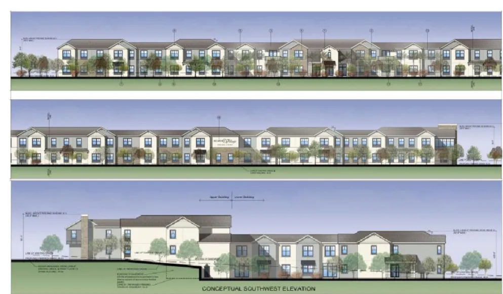
27
ARCHITECTURAL STYLES
highlights the elevations of the proposed buildings, showcasing the architectural styles that are being
proposed.
28
4.2
SURROUNDING ARCHITECTURE
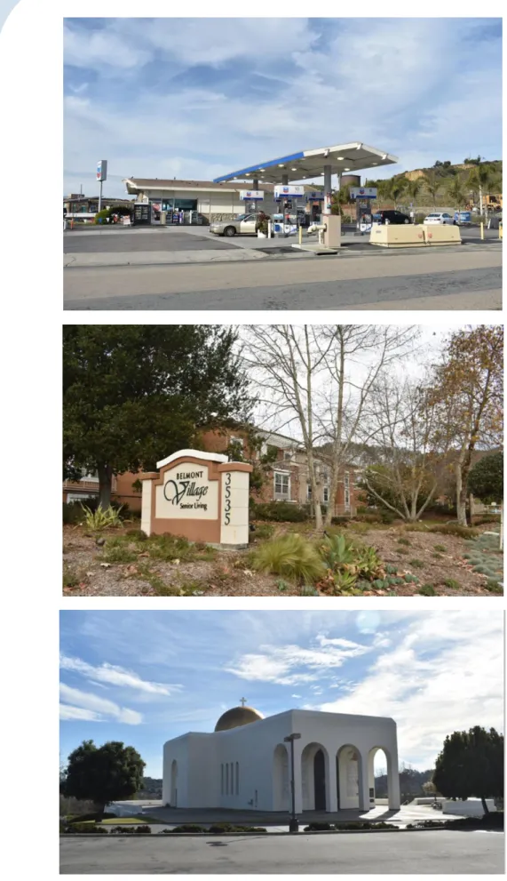
The architectural nature of Cardiff-by-the-Sea demonstrates a variety of styles in its context that date from the 1950s up to the present. Modest size dwellings dominate the neighborhood to the north, giving its residents a human scale context within their community. The surrounding neighborhood is an eclectic mix of Spanish (with authentic and contemporary expressions of the style), California Coastal Cottage, Italianate, and modern white washed Greek. The closest buildings are a part of the Mira Costa Community College which is rendered in contemporary Spanish Mission style with barrel tile roofs and a simple more modern formal language. The residential area on the bluff above the site is a mix of California Coastal Cottage, contemporary Spanish Mission style and authentic Spanish Mission style. Further east along Manchester is the Greek Orthodox church and the italianate Belmont Village Senior housing.
The photographic documentation that is shown in Figure 4-2 demonstrates the usage of eclectic architectural design patterns that dominate the community helping to portray visual qualities of building design, colors, materials, and architectural characters that new developments should reflect in their designs, to contribute to the overall diverse visual character of the localized area.
29
30 4.3 GUIDELINES
The City of Encinitas has established a set of design guidelines with the purpose to guide development within the City of Encinitas toward design that is consistent with the character of each community. The Design Guidelines are intended to promote well designed development in Encinitas. The Manchester senior housing project used the relevant policies within these guidelines as a resource to help create a design that followed the preferred architectural character and development patterns within Encinitas today. The design guidelines complement mandatory development standards by providing additional requirements and good examples of appropriate design solutions.
TABLE 4-2 DESIGN GUIDELINES
POLICY CONSISTENCY ANALYSIS/COMMENT
Building Location
Policy 2.4.2: The orientation of buildings, especially those in clusters, should be carefully designed to preserve and/or create view corridors.
Both the senior and workforce housing projects have been oriented to take advantage of the lagoon and hillside views afforded by the site as well as to preserve the views of adjacent neighbors. The senior building consists of radiating wings that not only break up the mass of the building, but also create open ended courtyards that allow views out for the tenants as well as views in for passers-by. The workforce units have been sited in a staggered pattern that allows for views from each unit as well as the village green.
Policy 4.5: In order to provide visual openness and pedestrian scale along major streets, heights of buildings or portions of buildings should generally be lower adjacent to the street corridor, stepping up to higher
elements.
The buildings step up the hillside as one moves away from the street frontage.
31
POLICY CONSISTENCY ANALYSIS/COMMENT
Views
Policy 2.5.2: Landscaped areas should be developed, and plant materials selected so as to create and/or preserve view corridors.
The Landscape has been designed to protect and preserve the views from Manchester and viewpoints adjacent to the site.
Policy 2.5.4: Projects should be designed to preserve some of the significant views through the site. Projects should be designed to preserve significant public views. A significant public view is a view of a significant feature (ocean lagoon or backcountry) as viewed from public parks and General Plan designed vista points and scenic view corridors. Trees and vegetation that are themselves part of the view quality should be retained.
The senior and workforce buildings hug the site as grade slopes up to the back. This strategy helps to maintain views over the proposed project from above and down the street. The site’s former agricultural use rendered it free of trees or native vegetation.
POLICY CONSISTENCY ANALYSIS/COMMENT
Separation and Buffers
Policy 2.6.5: Visual screening is best accomplished through the use of trees and shrubs that fill in at eye level. These visual screens should not be continuous and should allow for visual penetration through areas with views.
A naturalistic tree grove has been created to screen the building elevation from the scenic views of the San Elijo Lagoon. The Landscape setback which accommodates the tree grove will include varying height shrubs to create a continuous screen along the Manchester Avenue frontage.
32
POLICY CONSISTENCY ANALYSIS/COMMENT
Grading Principles
Policy 5.1.2: The impact on surrounding uses shall be considered in the building design.
The buildings sit low on the site in an effort to minimize interruption of views. Site access would be from Via Pico. This street would be shared with the adjacent Caltrans facility to avoid traffic stacking on Manchester Avenue.
Policy 5.1.4: The electric architectural nature in Encinitas should be reflected in any project.
The senior and workforce projects are rendered in different yet compatible styles to reinforce the eclectic quality of Encinitas.
Policy 5.3.2: Structures should be designed to create transitions in form and scale between large buildings and adjacent smaller buildings. For Example, if adjacent buildings are on story, new buildings should gradually transition from one story to two stories.
The site is not immediately adjacent to any buildings except for the houses on the bluff well above the site. A tangible scale difference will not be a factor.
Policy 5.3.3: Building forms should be designed to create visual interest. Changes in form accomplished by varying levels and
planes can create a visually interesting structure while minimizing the appearance of bulk.
Building massing has been manipulated to create visual interest with wings projecting into the landscape, smaller scale elements such as porches/trellises, and varies roofline.
Policy 5.3.6: Non-residential building facades should be staggered to decrease the commercial strip image as well as provide for additional visual interest and identification for separate retail stores. Building facades should have a compatible material treatment of all elements of the structure.
Colors and materials such as board and batten siding, stone, smooth trim, metal railings and stucco have been used to break up the façades of the proposed buildings.
33
POLICY CONSISTENCY ANALYSIS/COMMENT
Reduction of the Visual Bulk of Structures
Policy 5.4.1: The apparent mass of each building should be minimized by placing the building away from adjacent streets, thus allowing space for landscaping to soften the appearance of the building heights. In addition, the wall planes facing the streets should modulate, creating a varying street facade.
Projecting elements like porches, bay windows, barge brackets and trellises have been used to break up wall planes of the proposed buildings and create a varying street façade. Additionally, the buildings have been set well back from the street edge to allow for landscaping.
Policy 5.4.5: Rooflines should avoid extended flat horizontal lines.
A mix of gable, hip and parapet-wall roof elements break up the line where the building engages with the sky.
POLICY CONSISTENCY ANALYSIS/COMMENT
Color and Materials
Policy 5.5.1: Exterior facing materials are one of the major determinants of a building’s visual image. Variety in complementary exterior materials and colors should be used. Additional colors, materials and details including, but not limited to, fascia, trim, and railings ay be applied to small areas to emphasize certain features including entrances, desks, etc. Trim, fascia, rafter tails and the like should be of a sufficient dimension to achieve the desired visual effect and to be consistent with the overall character of the building design.
A variety of materials, colors and architectural details have been employed to create visual interest and reinforce the coastal agrarian theme. Appropriately scaled stone, siding, smooth board trim, barge brackets and fascia contribute to the facades’ balanced composition.
34
POLICY CONSISTENCY ANALYSIS/COMMENT
Architectural Character and Detailing
Policy 5.6.1: Buildings should include sensitive architectural detailing and careful selection of materials to enhance character definition. Special care should be given to building detailing on all visible sides of development, particularly at building entrances. Although side and rear elevations may be less intensely detailed than the front elevation, some recollection of front elevation materials and detailing shall be incorporated.
All sides of the proposed buildings will be equally detailed with an assortment of materials, massing elements and colors. The senior building’s entry is punctuated by a detailed porte cochere. Entries to the workforce housing units are highlighted by porches and boldly colored front doors.
4.4
RESOURCE MANAGEMENT ELEMENT POLICY CONSISTENCY
The City of Encinitas General Plan serves as a roadmap for the City’s physical, social, and economic development and contains goals and policies that strive to maintain the
City’s distinct community characters, provide a balance of land uses and services and
to preserve environmental resources. The evaluation of consistency with plans and policies is intended to provide a perspective on whether the Manchester Senior Housing project fits into the framework of goals and policies that the City has adopted to guide its future growth and development. These policies are intended to ensure that the existing character of developments are maintained, and that future development is compatible with existing land uses. Table 3-1 summarizes the relevant policies from the City of Encinitas’ General Plan Resource Management Element and provides a consistency review for the proposed project.
35
TABLE 4-3 RESOURCE
MANAGEMENT ELEMENT
POLICY
CONSISTENCY ANALYSIS/COMMENT
COMMUNITY VIEWS, VISTAS, AND AESTHETIC QUALITIESPolicy 4.5: The City will designate
“Scenic/Visual
Corridor Overlay” areas within which the
character of development would be regulated to protect the integrity of the Vista Points according to the following criteria:
- Development within the critical viewshed area should be subject to design review based on the following:
o Building height, bulk, roof line and color and scale should not obstruct, limit or degrade the existing views;
o Landscaping should be located to screen adjacent undesirable views (parking lot areas, mechanical equipment, etc.)
The project’s restrained facade treatments and simple roof gabled roof forms are intended to reflect the existing agrarian nature of the site and the history of Encinitas. Massing is enhanced by varied roof elements and materials such as siding, stucco and stone tile. Staggered façades and projecting wings will allow for a play of light and shadow on the buildings. Lower, smaller scale elements have been added to enhance the human scale of the project. Light to medium colors and materials will reinforce the agrarian theme and serve to reduce the mass of the buildings.
All proposed landscaping shall consist of non- invasive, drought tolerant native plant material and comply with the San Elijo Conservancy Coastal Sage Shrub Plant Field Guide. Any existing landscaping that does not meet the above requirements shall be removed. All planting shall be maintained in good condition throughout the life of the project. The project proposed enhanced paving at the entry points throughout the project as well as turf block in the firelane to mitigate the expanses of paving. Additionally, appropriately sized trees privately maintained shall be planted within the parkway for aesthetically pleasing screening.
36
Policy 4.6: The City will maintain and enhance thescenic highway/visual corridor viewsheds. (Coastal Act/30251)
The Scenic corridor regulations apply to all properties within the scenic view corridor along scenic highways and adjacent to significant viewsheds and vista points as described in the Visual Resource Sensitivity Map of the Resource Management Element of the General
Policy 4.10: It is intended that development would be subject to the design review provisions of the Scenic/Visual Corridor Overlay Zone for those locations within Scenic View Corridors, along scenic highways and adjacent to significant viewsheds, historic viewsheds and vista points with the addition of the following design criteria:
- Development Design
o Building and vegetation setbacks, scenic easements, and height and bulk restrictions should be used to maintain existing views and vistas from the roadway.
o Development regulated along any bluff silhouette line or on adjacent slopes within view of the lagoon areas and Escondido Creek.
Consideration will be given to the visual impact from a proposed development that may trigger design review within the Scenic View Corridor Overlay Zone. Evaluation of project bulk, mass, height, architectural design, grading, and other visual factors to ensure the visual impact of proposed development is properly assessed.
The proposed site development area is outside the existing steeper slope areas. The project footprint falls within the limits of the existing agricultural area. There is an established 100’ setback from the coastal bluff vegetation. All buildings will be located outside this 100’ setback. There will be limited slope grading and minor street/utility improvement areas within that setback zone. The building locations lie outside the limits of the flood plain established by FEMA for the site/lagoon drainage area, and the elevations of the building is set above the established elevation of the flood plain as required.
The site development area is outside the existing steeper slope areas as shown on page 16 (slope analysis). Everything is basically within the limits of the existing agricultural area and nit on the bluffs.
37
o Where possible, development should be placed and set back from the bases of bluffs, and similarly, set back from bluff or ridge top silhouette lines; shall leave lagoon areas and floodplains open, and shall be sited to provide unobstructed view corridors from the nearest scenic highway.
Development that is allowed within a viewshed area must respond in scale, roof line, materials, color, massing, and location on the site to the topography, existing vegetation, and colors of the native environment.
(Coastal Act/30251/30253)
Policy 4.11: The City will develop a program to preserve views that also preserves the appropriate vegetation and removes obstacles that impact views. Trees and vegetation which are themselves part of the view quality along the public right-of-way will be retained. (Coastal Act/30251)
The project will have an established 100’ setback from the coastal bluff vegetation, which is ultimately the toe of the bluff slopes. All of the proposed buildings are located outside the 100’ setback. There is limited slope grading and minor street/utility improvement areas within that setback zone. The plan was developed to keep the building locations outside the limits of the flood plain established by FEMA for the site/lagoon drainage area, and the elevations of the building is well above the established elevation of the flood plain as required.
The proposed project is located on a site that was previously disturbed for agricultural purposes, free of any significant landscaping features and the surrounding properties have also been developed with institutional, residential and commercial development. The project would not open any undeveloped natural area for