145
MODERN METHODS IN PREPARING DOCUMENTATION FOR
DETACHMENT OF A REAL ESTATE AND DRAWING ON FIELD THE
LIMITS OF RESULTED PROPERTIES
MILUȚ MARIUS, CĂLINA JENICA, CROITORU ALIN
University of Craiova, Faculty of Agriculture and Horticulture
Keywords: detachment, cadastral documentation, draw, modern devices
ABSTRACT
In the past 20 years, along with the exponential growth of computer science, have developed devices, technologies and means that have led to increased accuracy for determining the elements measured decrease the time required for data acquisition and processing in topographic measurements hence the time required of preparing the cadastral documentation. Practically every year there are new devices and software for data processing and representation of the terrestrial measurements or theirs improved versions. The paper presents the case study of a property detachment situated in the Agigea commune, Lazu village, T12, A428/2/1/2/1, Constanta County.
INTRODUCTION
In principle, the position in the plane and space (coordinates x, y, z) of the boundary points, chosen and marked by cadastral delimitation shall be determined in the national reference system. For this purpose are the following:
- determinations are based on geodetic support network points used as known elements starting and / or control;
- border points considered important by their position may be included from the start in network support and determined accordingly by GPS;
- the set of delimitation points is included, usually in traverse routes falling within the network of support and taken with total stations. Some points could be determined and by double sighting or intersections;
- as a general rule, the position errors of boundary points must be within the tolerances set for surveying network, respectively for traverse stations, even if they resort to other ways of working;
- Classical apparatus could be used but do not fall in the calculations due to their obviously lower efficiency and accuracy, comparing with electronic instruments.
Measurements follow the characteristic elements of the method and the points are specifically obtained by the used instrument as follows:
- in modern processes, some border points, important by their position are deducted directly in GPS system after processing the data recorded by receivers.
- those relating by traverse taken with total stations are automatically recorded either geometrical elements (angles, distances, device and prism height) either directly x, y, z coordinates of the points, including coordinates of the closure point for control;
Calculations are specific to methodes and are performed by running on computer the appropriate programs. In this regard note that:
- for total stations, the error of closure on each axle is compensated proportional to the edge length. When read directly coordinates (x, y), corrections are brought to values from field proportionally with the distance accumulated from the beginning of traverse;
146
MATERIAL AND METHODES
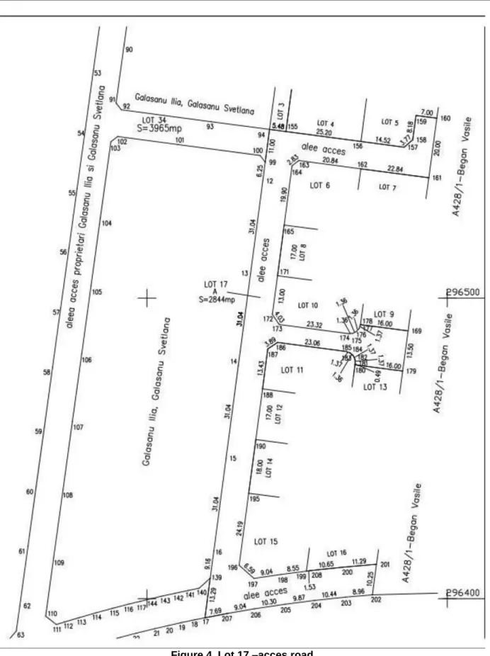
The subject of work was the property located in the area of the village Lazu, common Agigea, T12 A428/2/1/2/1, Constanta County. The total area from measurements is 14753 sq.m. For this surface was drawn up cadastral documentation registered at OCPI Constanta, the surface receiving provisional cadastral number 109019, registered in CF Agigea. At the request of the owner the surface of 14753 sqm was cut out into 17 lots as follows:
- Lot 1 - arable area of 118 sq.m. - Lot 2 - arable area of 4762 sqm - Lot 3 - arable area of 118 sq.m. - Lot 4 - arable area of 543 sq.m. - Lot 5 - arable area of 642 sq.m. - Lot 6 - arable area of 498 sq.m. - Lot 7 - arable area of 499 sq.m. - Lot 8 - arable area of 503 sq.m. - Lot 9 - arable area of 472 sq.m. - Lot 10 - arable area of 466 sq.m. - Lot 11 - arable area of 465 sq.m. - Lot 12 - arable area of 500 sq.m. - Lot 13 - arable area of 464 sq.m. - Lot 14 - arable area of 817 sq.m. - Lot 15 - arable area of 575 sq.m. - Lot 16 - arable area of 467 sq.m.
- Lot 17 - 2844 sq.m. arable area – designed as alley access.
Surveying works were carried out with a total station PENTAX V227-N and Leica SR530 GPS receiver.
Figure 1. Pentax V227-N total station
147
RESULTS AND DISCUSSIONS
For the execution of documentation detachment was executed on land a recognition of the limits of building which consisted of:
- Recognition of access roads; - Recognizing the corners of fences;
- Recognition of the existing electricity networks in the area;
- Recognition of the support points from the existing state geodetic network in the area;
Was performed an informative outline of the surveyied property.
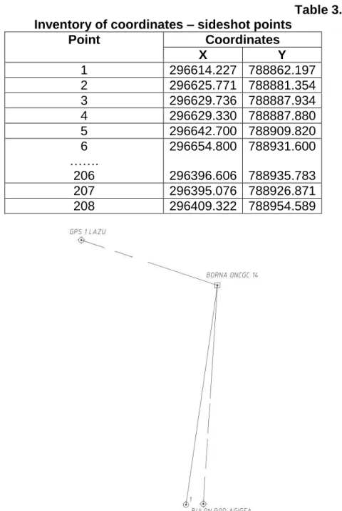
It was found in the area 3 points previously determined, namely: landmark 14 of the national geodetic network, bolt bridge Agigea, GPS 1Lazu, the last two being determined by GPS receivers by static method. In addition to these points has been determinate new point (1) using GPS technology (static method).
Based on these points were made tracings at points lying on the main alignments, which are evidenced with metal pickets. Tracing was performed using GPS measurements in RTK (Real Time Kinematic) by receiving differential corrections received from ROMPOS using a Leica SR530 GPS receiver. The remaining items on the contour plots resulting from detachment are drawn with total station with measurements on alignments.
Coordinates of the point’s calculations were made using specialized software (TopoSys 7.0). TopoSys 7.0 is geodetic specialized software with enhanced functionality using modern computational concepts and procedures in order to resolve the reference geodetic observations performed with total stations and GNSS technology. TopoSys includes all the functionality needed to define and use coordinate reference systems according to international standards, with a large number of coordinate systems defined on local or global geodetic datum. Internal methods of filtering errors and compensation data by method of least squares are the result of scientific research in the field, tested on countless surveying and geodetic measurements both on local networks and the national GNSS network.
Knowing surfaces to be detached and having property initial contour in Stereo 1970 coordinate system, was executed detachment of areas as those required by the owners.
In the following tables are shown old and new points coordinates and some of the detachment points traced:
Table 1. Inventory of coordinates - old points used
Point Coordinates
X Y
Landmark 14 296722.680 789072.410
Bolt bridge Agigea 295330.340 788982.750
GPS 1 Lazu 296952.340 788380.140
Table 2. Inventory of coordinates - new determined point
Point Coordinates
X Y
1 296108.140 788984.380
148
Table 3. Inventory of coordinates – sideshot points
Point Coordinates
X Y
1 296614.227 788862.197
2 296625.771 788881.354
3 296629.736 788887.934
4 296629.330 788887.880
5 296642.700 788909.820
6 296654.800 788931.600
…….
206 296396.606 788935.783
207 296395.076 788926.871
208 296409.322 788954.589
Figure 3. Drawing of the support network
149
Figure 4. Lot 17 –acces road
Tracing on field corner of lots resulting from detachment was performed in the presence of the owners, this is executing before making technical documentation for reception OCPI Constanta.
Documentation of detachment included:
150
- request to receive documents for detachment;
- declaration on their honor on alienation and identification of measured property; - extract from the land registry for information;
- description of topographic and geodetic works;
- site and delimitation plan of the property at scale 1:1000 with the proposed of detachment in duplicate;
- site and delimitation plans for each property resulting of detachment, in duplicate; - measurements in the thickening and surveying network and topographic details for each property resulting from dismemberment through traditional methods and GPS technology;
- calculation of areas;
- topographical descriptions of new points of thickening and surveying network; - proof of payment of fees for reception and registration in the land register (Regulation ANCPI).
Based on the documentation prepared, was requested entry in the Land Register of legal acts and facts relating to property detachment.
CONCLUSIONS
In the past 20 years, along with the exponential growth of computer science, have developed devices, technologies and means that have led to increased accuracy for determining the elements measured, decrease the time required for data acquisition and processing in the field of topographic measurements.
Every year appears new devices and software for data processing and representation of the terrestrial measurements or theirs improved versions. Their use led to decreasing the time needed to complete cadastral documentation.
BIBLIOGRAPHY
Călina A. and al., 2010, Topografie generală şi inginerească, Ediţia a II-a, Editura Sitech, Craiova.
Călina A. and al., 2010, Dividing of some properties from Ghercesti outside limits, Dolj County, Analele Universităţii din Craiova, seria Agricultură-Montanologie -Cadastru, vol XL/B, Ed. Universitaria, Craiova;
Păunescu C., 2004, Curs geodezie – topografie vol. III, Editura Universităţii din Bucureşti, Bucureşti ;
XXX, Ordinul directorului general al ANCPI nr. 634/2006 din 13/10/2006 pentru aprobarea
"Regulamentului privind conţinutul şi modul de întocmire a documentaţiilor cadastrale în vederea înscrierii în cartea funciară", publicat în Monitorul Oficial, Partea I nr. 1048 din 29/12/2006;
http://www.leica-geosystems.com/en/Downloads
http://www.pentaxsurveying.ro