ISSN Online: 1945-3108 ISSN Print: 1945-3094
Hydrogeochemistry of Groundwater from
Different Aquifer in Dimbhe Command Area
of Ghod River, Maharashtra India
Geeta Pillai, Iftekhar A. Khan
Department of Geology & Petroleum Technology, N. Wadia College, Pune, India
Abstract
The groundwater geochemistry of Dimbhe command area of Ghod River ba-sin was evaluated based on major ions characteristic to decide its suitability for drinking, domestic use, and irrigation. Groundwater samples from differ-ent depth (shallow and deep) aquifer were collected and investigated for pH, electrical conductivity (EC), total dissolved solid (TDS), Ca, Mg, Na, K, Cl, SO4, CO3, HCO3, NO3, Fe, and Mn. The results show that the shallow groundwater is dominated by Ca-HCO3 and Na-HCO3 and deep aquifer by Na-HCO3 water facies. The sodium adsorption ratio (SAR) and salinity ha-zard indicate that the groundwater from the shallow and deep aquifer is suita-ble for irrigation purposes, and part of the intermediate aquifer is not suitasuita-ble for crop irrigation. Groundwater from the shallow and deep aquifer is re-garded as fresh water and suitable for drinking, domestic and agricultural ir-rigation use.
Keywords
Dimbhe Command Area of Ghod River, Hydrochemical Facies, Sodium Adsorption Ratio (SAR)
1. Introduction
The biosphere’s main available freshwater and essential resource is groundwater. The world depends on groundwater for intake water supply, green growth, and industrialized purposes as well as for worldwide foodstuff safety. Nearly world’s thirty-three percent inhabitants depend on subsurface water for drinking pur-pose [1]. The geochemistry of water is depends on rock type of an area, also the amount of chemical weathering of rock and man induced factor like land-use affect the chemistry of groundwater [2]. The combination of productive soil,
How to cite this paper: Pillai, G. and Khan, I.A. (2017) Hydrogeochemistry of Groundwater from Different Aquifer in Dimbhe Command Area of Ghod River, Maharashtra India. Journal of Water Re-source and Protection, 9, 656-662.
https://doi.org/10.4236/jwarp.2017.96044
Received: January 26, 2017 Accepted: May 24, 2017 Published: May 27, 2017
Copyright © 2017 by authors and Scientific Research Publishing Inc. This work is licensed under the Creative Commons Attribution International License (CC BY 4.0).
http://creativecommons.org/licenses/by/4.0/
G. Pillai, I. A. Khan
moderately undulating topography with the superficial water level and wide-spread of the aquifer with plentiful and easily accessible of water make the groundwater the main source of water among the residents in the Dimbhe command area of Ghod river basin. About 75% populations living in the Ghod river basin are dependent on surface and subsurface water for domestic, farming and industrial activities. The subsurface water requires negligible treatment and remains nearly unaffected throughout extended drought period. However, the basaltic aquifers are generally delicate, easily exhausted due to manmade actions and over use of groundwater [3]. With the growing populaces distributed over a large geographical area, the demands of groundwater increased in command area [3][4].
In industry and agriculture activities, there has been increasing concern about the quantity and quality of groundwater resources [5]. For sustainable manage-ment and safeguard of precious groundwater resources, the categorization and understanding of the environmental evolution of subsurface geochemistry are crucial to explain their element nature and its relation [6]. Presently, the hydro-geochemistry study of subsurface water in this area has not been examined in depth on a basin-wide scale and poorly unwritten. The aim of this paper is to portray the groundwater class in the Ghod river basin in multi-layered aquifer using geochemical analysis.
2. Material and Methodology
2.1. Study Area
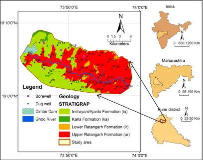
The River Ghod originates in the Bhimashankar area at approx. 1090 m above sea level. It is a tributary of the River Bhima that flows in an east-southeast di-rection for approximately 200 km before its confluence with the River Bhima. It flows from the northern side of the Bhimashankar hills. The Ghod River itself has two tributaries-River Meena and River Kukadi. There is a long canal con-structed along the Ghod river bank. The Dimbhe dam is located in the Ghod ba-sin and is part of the Kukadi project. Figure 1 is location map of the study area. The right side of figure shows the India showing Maharashtra state having Pune district and study area.
The Dimbhe reservoir is designed to irrigate hectares of land and generate 5 MW power through a powerhouse built at the downstream of the dam. The study area experiences good to high rainfall during the southwest monsoon (June-August) and northeast monsoon (October-December) seasons. The mea- sured rainfall varies from 650 to 900 mm/day. The temperature of the area varies from 20˚C to 34˚C and the maximum in the summer seasons.
The study area is occupied by the horizontal flows of basalt, showing Ajanta, Karla, Lower Ratangarh and Upper Ratangarh Formation (Figure 1).
2.2. Sampling and Analytical Procedures
Figure 1. Location map of study area showing sampling location.
chosen in order to indicate the groundwater quality in the study region (Figure 1). The subsurface samples were collected in prewashed sampling bottle. The physicochemical parameter measured in the field immediately after were pH, temperature, electrical conductivity (EC), and total dissolved solids (TDS) using the handheld meter and data-logging. All samples brought to the laboratory and stored at 4˚C. The samples were collected in 1 Liter and 100 ml sampling bottles. The 100 ml sample is acidified with nitric acid (HNO3) to maintain a pH of less than 2 to reduce adsorption of metals to container walls and decreases biological activity. Future the samples were filtered through 0.45 μm membrane filter to remove unwanted suspended particle. All the groundwater collection method and the water sample analysis followed standard procedure [7].
The Ca, Mg, HCO3 and Cl− were analysed by titrimetric methods [7]. The Na and K concentrations were determined by flame photometric method while
2 4 SO −, PO34
−, and 3
G. Pillai, I. A. Khan
3. Result and Discussion
3.1. Hydrogeochemical Facies
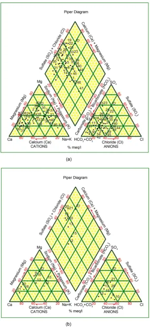
Hydrogeochemical diagrams are aimed at facilitating interpretation of evolu-tionary trends, particularly in groundwater system, when they are interpreted in conjunction with distribution maps and hydrochemical sections [9]. The Piper diagram in Figure 2(a) shows the prominent groundwater facies of the shallow aquifer is Ca-HCO3 and Na-HCO3 indicating fresh and mix-water types respec-tively. In deep groundwater aquifer (Figure 2(b)), Na-HCO3 type water is dominant. Ca-HCO3 facies indicate that the groundwater samples are associated with calcite solution. The majority of groundwater resources were Ca + Mg − HCO3 + CO3 dominant as the dissolution of primary silicates due to process of chemical weathering [10]. Despite this, the water from Ca − Mg rich basaltic flows, the surface water is always deprived with Ca and Mg because of setting of those ions in their carbonates as the result of alkaline nature of water. Also, ma-jority of the wells occupies the inner diamond area as rock dominance preva-lence. Dug wells or shallow groundwater are evenly embedded in diamond area, while bore wells or deep groundwater bowing towards Ca + Mg − HCO3 + CO3 due to long residence time available for rock-water interactions [11].
It is observed that changing of Ca + Mg − HCO3 + CO3 to Na + K − SO4 + Cl is more in bore well or deep aquifer than dug well or shallow aquifer [12]. This is due to greater depth of bore well wherein high residence time groundwater ex-ists due to the increased rock-water interaction. However, surface water is hav-ing high evaporation that results into feeble displacement in Ca + Mg − HCO3 + CO3 to Na + K − SO4 + Cl water facies due to less rock-water interaction [12].
3.2. Sodium Adsorption Ratio (SAR)
The groundwater quality from shallow and deep aquifer were classified and compared with sodium absorption ratio (SAR). The SAR calculate the ions of sodium (Na+) to calcium (Ca2+) and magnesium (Mg2+) ratio in groundwater samples. Sodium hazard of irrigation water is important in classifying the water for agriculture purposes because sodium concentration can reduce the soil per-meability and soil structure [13] and calculated by using Equation (1) [14]
+ 0.5 2+ 2+ Na Ca Mg 2 SAR= + (1)
G. Pillai, I. A. Khan
Figure 3. USSL graphical diagrams of shallow groundwater and deep groundwater.
cates low to high salinity and low to medium alkalinity water, which can be used for irrigation in almost all types of soils with a little danger of exchangeable so-dium.
4. Conclusion
Results of the analysis show that the shallow groundwater type is dominated by Ca-HCO3 and Na-HCO3 and deep groundwater Na-HCO3 as basaltic ground-water. The Na-HCO3 facies could be due to albite solution of weathered Gyroli-teand Siderophyllite of the study area. The bicarbonates are mainly derived from carbonate mineral and silicate weathering. However, salinity in study area is to be added with increase in annual rainfall which offers sufficient aqueous me-dium for rock/soil-water interaction under in semi-arid climatic regime. The process of rock dominance is dominant followed by precipitation and evapora-tion. Finally, the groundwater of the Ghod river Basin is suitable for drinking, domestic and agriculture irrigation use. The people from study area will have adopted sustainable water use plan for surface and subsurface water to monitor and control groundwater quality for anodyne usage of the resource.
Acknowledgements
The authors are thankful to Principal, N. Wadia College Pune, India for extend-ing help to use the department laboratory for computextend-ing facilities.
References
[1] United Nations Environment Program (UNEP) (1999) Global Environment Out-look 2000. Earthscan, UK.
Groundwater in the Proximity of River Cooum, Chennai, India. Environmental Monitoring and Assessment, 143, 161-178.
https://doi.org/10.1007/s10661-007-9965-y
[3] Ismail, T. and Anuar, S. (2010) Potential of Groundwater Contamination in North Kelantan. Proceedings of Seminar Geofizik Kejuruteraandan Sekitaran, 6 Januari 2010, Program Geologi, PPSSSA, FST, UKM 2010, 155-163.
[4] Kadam, A.K., Kale, S.S., Pande, N.N., et al. (2012) Identifying Potential Rainwater Harvesting Sites of a Semi-Arid, Basaltic Region of Western India, Using SCS-CN Method. Water Resources Management, 26, 2537-2554.
https://doi.org/10.1007/s11269-012-0031-3
[5] Alvarado, A., Esteller, M.V., Quentin, E. and Expósito, J.L. (2016) Multi-Criteria Decision Analysis and GIS Approach for Prioritization of Drinking Water Utilities Protection Based on Their Vulnerability to Contamination. Water Resources Man-agement, 30, 1549-1566. https://doi.org/10.1007/s11269-016-1239-4
[6] Arauzo, M. and Martínez-Bastida, J.J. (2015) Environmental Factors Affecting Dif-fuse Nitrate Pollution in the Major Aquifers of Central Spain: Groundwater Vul-nerability vs. Groundwater Pollution. Environmental Earth Sciences, 1-16.
[7] APHA (2005) Standard Methods for the Examination of Water and Wastewater. 20th Edition, American Public Health Association, Washington DC.
[8] Hem, J.D. (1989) Study and Interpretation of the Chemical Characteristics of Natu-ral Water. 3rd Edition, United States Geological Survey, Washington DC.
[9] Piper, A.M. (1944) A Graphical Interpretation of Water Analysis. Transactions- American Geophysical Union, 25, 914-928.
https://doi.org/10.1029/TR025i006p00914
[10] Pawar, N.J., Thigale, S.S. and Powar, K.B. (1982) Chemistry of Groundwaters from Pune Area, Maharashtra. Proceedings of International Symposium on Hydrological Aspects of Mountainous Watersheds, Roorkee,Vol. I, X1-X6.
[11] Pawar, N.J., Pawar, J.B., Suyash, K. and Ashwini, S. (2008) Geochemical Eccentricity of Ground Water Allied to Weathering of Basalt from the Deccan Volcanic Prov-ince, India: Insinuation on CO2 Consumption. Aquatic Geochemistry, 14, 41-71.
https://doi.org/10.1007/s10498-007-9025-9
[12] Rajmohan, N. and Elango, L. (2005) Distribution of Iron, Manganese, Zinc and Atrazine in Groundwater in Parts of Palar and Cheyyar River Basins, South India. Environmental Monitoring and Assessment, 107, 115-131.
https://doi.org/10.1007/s10661-005-5307-0
[13] Todd, D.K. (1980) Groundwater Hydrology. 2nd Edition, John Wiley and Sons, New York, 535.
[14] Richards, L.A. (1954) Diagnosis and Improvement of Saline and Alkaline Soils Ag-riculture Handbook. Department of Agricultural, Washington DC, 160.
Submit or recommend next manuscript to SCIRP and we will provide best service for you:
Accepting pre-submission inquiries through Email, Facebook, LinkedIn, Twitter, etc. A wide selection of journals (inclusive of 9 subjects, more than 200 journals)
Providing 24-hour high-quality service User-friendly online submission system Fair and swift peer-review system
Efficient typesetting and proofreading procedure
Display of the result of downloads and visits, as well as the number of cited articles Maximum dissemination of your research work