Relatively scarcity of land resources for agri-culture and insufficient food security of world’s population require that the land be used in an optimum way. Based on FAO report (1991), 91% of developing countries (not including China) are potentially capable of dry farming on 2573 mil-lion ha which, in comparison with 757 milmil-lion ha of irrigated land, is a considerable area. In arid and semiarid areas such as Iran, the problem of optimum land use is highly relevant. In Iran, 32 million ha of agricultural soils are suitable for crop cultivation, either rainfed or irrigated, pro-vided that competent soil studies are carried out to indicate suitability of these soils for particular
use under particular climate (Sys & Verheye 1974). The land suitability is assessed as a part of the rational cropping system (FAO 1976, 1983), in which the land use is optimised for a specific purpose (Sys et al. 1991a). Wheat, barley, alfalfa, maize and safflower are important crops com-mercially produced in major parts of Iran and also in the East & West Azerbaijan provinces, where their production depends very much on climate, soil, topography and water availability. These are the most important categories of environmental information required for judging land suitabil-ity. In different parts of Iran, land suitability was evaluated for some of these crops by Movahhedi
Land Suitability Evaluation of Bilverdy Research Station
for Wheat, Barley, Alfalfa, Maize and Safflower
Ali Asghar JAfARzAdeh, Parisa AlAmdARI, mohamed Reza NeyShAbOuRI
and Siamak SAedI
department of Soil Science, faculty of Agriculture, university of Tabriz, I.R. of Iran
Abstract: In the present study and research work, land suitability evaluation (qualitative classification) was made for the Bilverdy research station of the Islamic Azad University in East Azarbaijan for wheat, barley, alfalfa, maize and safflower. The Simple Limitation Method (SLM), the Limitation Method regarding Number and Intensity (LMNI) and the Parametric Methods (PM) such as the square-root and the Storie methods were used. The landscape, climate and soil and characteristics that influence suitability of the land for particular crops have been combined according to the adopted methodology. Economic factors were excluded and moder-ate level of management was assumed. The results of different methods show that the most important limiting factors are climate, pH, organic matter (OM), gravel, salinity and sodicity, taken either alone or in combination. For safflower, the cation exchange capacity (CEC) can be added to these factors. Evaluation by the SLM and LMNI methods result in similar suitability classes, which confirms previous findings by other researchers for the same crops. However, in many cases the use of parametric methods, especially the square-root method, turned to be more realistic in distinguishing separate suitability classes. This study not only compares different methods and their results but also evaluates the suitability of the study area for particular crops. According to the square-root method, the area can be recommended as marginally suitable for cultivation of wheat, barley, alfalfa and safflower and is expected to yield about 40–65% of optimal production.
Naeni (1993), Ghasemi Dehkordi (1994), Sar-vari and Mahmoudi (2001), Jafarzadeh and Atabakazar (2004), Jafarzadeh et al. (2005a, b), Jafarzadeh and Abbasi (2006), and Shah-bazi and Jafarzadeh (2004), in order to find an optimum use for each land unit.
Purpose of this study is, first, to confirm the results of previous researchers as to the perform-ance of different land evaluation methods and, second, to provide actual evaluation of the study area suitability for particular crops, based upon the Simple Limitation Method (SLM), the Limitation Method regarding Number and Intensity (LMNI) and two Parametric Methods (PM).
MATERIALS AND METHODS Site and climate characteristics
Bilverdy research station with about 106 ha total area lies between 46°08' and 46°40' East latitudes and between 35°08' and 35°12' North longitudes. The altitude of the region is about 1550 m above sea level. The area is mainly used for wheat cultiva-tion, while the rest is covered by native vegetation of acroption (Compositae L.), achillea (Compositae L.), chenopodium (Chenopodiaceae L.), alhaji (Papilionaceae L.) and salsola (Chenopodiaceae L.) (Alamdari 2004). The slope varies between 1% and 5%. There is no drainage problem in this area. The most important climate characteristics necessary for land suitability estimation (temperature, rain-fall and relative humidity) were collected from the
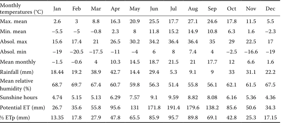
Ahar meteorological station (Table 1), where the average annual total rainfall is about 302.8 mm, with the mean and maximum annual temperatures being 4.8°C and 17.5°C, respectively.
[image:2.595.64.533.551.757.2]Soil characteristics and land qualities In order to obtain reliable soil data, the available soil survey reports were inspected and, based on this, nine representative soil profiles were chosen for a more detailed investigation within different land units with different average slope steepness. Soil profile descriptions (Table 2), samplings and analyses were made using standard terminology and procedures (Soil Survey Staff 1993). The soils were classified by Saedi and Jafarzadeh (2004) and Saedi et al. (2005) according to USDA classifica-tion system (Soil Survey Staff 2006) as belonging to the Aridisols order, Sodic Haplocambids and Typic Haplocambids suborders (Table 3). Accord-ing to the map of soil temperature and moisture regimes of Iran (Banaei 1998), the soil temperature and moisture regimes of the area were identified as mesic and aridic, respectively. In the process of qualitative land suitability evaluation, it is the physical soil characteristics (texture, structure, stones, profile depth, CaCO3 status and gypsum status), the fertility characteristics not easy to cor-rect (apparent cation exchange capacity (CEC), sum of exchangeable base cations, pH in H2O, organic matter) and the salinity and alkalinity that play an important role. The land qualities such as the moisture and oxygen availability and the foothold
Table 1. Climatic characteristics from the Ahar meteological station
Monthly
temperatures (°C) Jan Feb Mar Apr May Jun Jul Aug Sep Oct Nov Dec Max. mean 2.6 3 8.8 16.3 20.9 25.5 17.7 27.1 24.6 17.8 11.5 5.5 Min. mean –5.5 –5 –0.8 2.3 8 11.8 15.2 14.9 10.8 6.3 1.6 –2.3 Absol. max 15.6 17.4 21 26.5 30.2 34.2 36.4 36.4 35 29 22.5 17 Absol. min –19 –20.5 –17.5 –11 –4 6 8 7.4 4 –2.5 –16.6 –19 Mean monthly –1.5 –0.6 4 10.3 14.5 18.7 21.5 21 17.7 12 6.6 1.6 Rainfall (mm) 18.44 19.2 38.9 42.7 14.4 29.4 5.3 9.1 9 33 31.1 22.2 Mean relative
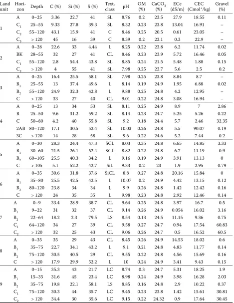
Table 2. Analytical characteristics of representative soil profile for land units of the study area
Land
unit Hori-zon Depth C (%) Si (%) S (%) Text. class pH OM (%) CaCO(%) 3 (dS/m)ECe (CmolCEC +/kg) Gravel (%)
1
A 0–25 3.36 22.7 41 SL 8.76 0.2 23.5 27.9 18.55 0.11 C1 25–55 9.33 27.8 39.3 SL 8.32 0.23 23.8 13.04 16.91 – C2 55–120 43.1 15.9 41 C 8.46 0.25 20.5 0.61 23.05 – C3 > 120 45 16 39 C 8.39 0.2 22.1 0.3 22.9 –
2
A 0–28 22.6 33 4.44 L 8.25 0.22 23.8 6.2 11.74 0.02 BK 28–55 32 27 41 CL 8.46 0.23 23.9 5.72 16.46 0.05 C1 55–120 2.8 54.4 43.8 SL 8.85 0.24 21.5 5.48 1.88 0.15 C2 > 120 4 55 41 SL 7.98 0.25 22.7 5.6 2.5 0.2
3
A 0–25 16.4 25.5 58.1 SL 7.98 0.25 23.8 8.84 8.7 – B1 25–55 13 37.4 49.6 L 8.14 0.19 24.9 1.95 6.88 0.02 B2 55–120 24.9 32.3 42.8 L 9.88 0.25 24.8 4.2 12.95 – C > 120 33 27 40 CL 9.01 0.22 24.8 3.08 16.94 –
4
A 0–25 13 34 53 SL 8.11 0.25 24.9 8.9 7 2.86 B 25–50 9.6 31.2 59.2 SL 8.14 0.23 24.7 5.25 5.26 0.22 C 50–80 4.2 40 55.8 SL 9.2 0.18 24.4 5.7 2.46 32.35 2AB 80–120 17.1 30.5 52.4 SL 10.03 0.26 24.8 5.5 90.07 0.19 3C > 120 14 28 58 SL 9.6 0.22 24.6 5.2 7.44 0.2
5
A 0–30 28.3 24.4 47.3 SCL 8.03 0.35 24.8 6.65 14.85 3.33 B1 30–60 21.5 26.1 52.4 SCL 8.82 0.22 24.8 6.7 11.19 0.9 B2 60–105 25.5 40.3 34.2 L 9.16 0.19 24.9 3.91 13.13 0 C > 105 5.1 52.2 42.7 SiL 9.33 0.2 23 1.9 2.95 0.79
6
A 0–35 30.6 31.8 37.6 SiCL 8.8 0.27 24.8 20.16 15.84 0 B1 35–80 25.5 42.5 42.5 L 10.07 0.2 24.9 4.42 13.15 0.12 B2 80–120 23.8 34 34 L 9.9 0.26 24.8 1.42 12.42 0.16 C > 120 24 35 35 L 9.98 0.23 24.8 2.92 12.46 0.14
7
A 0–9 33.4 28.9 38.7 CL 9.64 0.25 24.8 3.97 16.7 0.5 B1 9–22 31 32 37 CL 9.14 0.26 24.9 0.054 16.02 3.16 B2 22–64 18.2 2.3 79.5 LS 8.54 0.13 24.5 11.15 9.36 0.75 C1 64–120 34 27 39 CL 9.58 0.27 24.7 0.94 17.54 60.83 C2 > 120 32 25 43 CL 9.06 0.26 24.7 0.5 16.52 60.5
8
A 0–35 35 29 43 CL 8.45 0.26 24.9 14.53 18.02 0.6 B1 35–75 22.7 34.1 43.2 L 9.1 0.21 24.8 4.83 11.77 0.14 B2 75–120 30.5 40.5 29 CL 9.55 0.22 24.8 4.56 15.69 0.16 C > 120 17.9 29.9 52.2 L 10 0.24 24.9 3.41 9.43 0.15
9
A 0–15 35.3 43 21.7 LC 8.74 0.3 24.7 5.31 18.25 1.9 B1 15–35 31.6 45 23.4 LC 8.98 0.24 24.9 3.98 16.28 2.03 B2 35–75 19.8 22.1 58.1 LS 8.85 0.16 24.8 2.9 10.22 0.37 C1 75–120 30.3 44 35.7 LC 9.45 0.23 23.8 1.42 15.61 30.81 C2 > 120 34.4 30 35.6 LC 9.15 0.22 24.32 0.9 17.64 30.45
for root development depend to a large extent on the soil texture, the content of coarse fragments and stones, the soil depth and structure. The coarse fragments, present as gravel and cobbles at the surface and in the top 20 cm layer, influence tillage conditions and the capacity of the soil to retain nutrients and water. Experience has shown that most crops produce excellent yields with an effec-tive root zone depth of 90 to 100 cm. Therefore, for annual crops, the dense root system is usually assumed to occur within the upper 100 cm, while most tree crops have a dense to moderate root system up to the 150 cm depth.
The textural classes to be used for land suit-ability evaluation were recalculated using depth-weighting factors up to the depth 1 m for annual crops and up to 1.5 m or up to an impermeable layer for perennial crops. When the content of gypsum in the root zone is higher than 25% and the mean lime and gypsum content decreases with depth within the top 30 cm layer, then the lime and gypsum content in the soil was evalu-ated for this upper 30 cm only. In the other cases, the recalculated lime and gypsum content, using depth-weighting factors, was taken. The apparent CEC (ACEC) of the B horizon, or at 50 cm depth for A–C profiles, or just at the lithic or paralithic contact if this was present within 50 cm from the surface, was calculated as the weighted average of the sum of the exchangeable Ca, Mg and K, tak-ing into account pH and organic matter (OM) in the upper 25 cm of the soil. In the irrigated land, salinity and alkalinity evaluation was made for the 100 cm depth from the soil surface, while the salinity evaluation for annual crops with shallow
root systems was calculated as a weighted average of the upper 50 cm only.
Land suitability evaluation
The crop requirements with respect to climate, landscape and soil were summarized in separate tables according to Sys et al. (1993). With the help of these tables, the qualitative land suitability evalu-ation was done for wheat (Triticum spp. L.), barley (hordeum vulgare L.), alfalfa (medicago sativa L.), maize (zea mays L.) and safflower (Carthamus tinctorius L.) by comparing the actual soil charac-teristics and qualities with the crop requirements. The lands were classified using the Simple Limitation Method (SLM), the Limitation Method regarding Number and Intensity (LMNI) and two Parametric Methods (PM), namely, the square-root and the Storie methods (Sys et al. 1991a, b).
Simple limitation method (SLM)
[image:4.595.82.531.584.756.2]The simple limitation method implies that the crop requirement tables are made for each land utilisation type. For each characteristic, the tables define the class-level criteria. The methodology suggests that, in the first place, an evaluation of the climatic characteristics is made, with an aim to determine a climate class level to be used in the following evaluation. The climate class level is determined by the lowest class level among those found for particular climatic characteristics. Then, similarly, the land class is determined by the lowest class level among those found for particular soil characteristics. The SLM was used, for example,
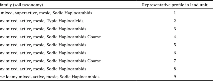
Table 3. Families of representative soils in the study area (Saedi & Jafarzadeh 2004; Saedi et al. 2005)
Soil family (soil taxonomy) Representative profile in land unit Fine mixed, superactive, mesic, Sodic Haplocambids 1
by Osie (1993) for qualitative land suitability de-termination of five soil series in South-Western Nigeria for crops such as maize, rice and cassava, cultivated under rainfed conditions.
Limitation method regarding number and intensity of limitations
This method defines land classes according to number and intensity of limitations. The crop requirement tables are requested which define limitation levels for each characteristic. The meth-odology evaluates, in the first place, the climatic characteristics, regrouped according to radiation, temperature, rainfall and humidity. For each cli-matic characteristic group, the most severe limi-tation determines the climatic suitability class, which is then used as the corresponding limitation level for the total land evaluation. The evalua-tion is carried out by comparing the actual land characteristics with the limitation levels defined by the crop requirement tables. This method is more difficult than SLM, but the approach is more accurate, because it considers the land with sev-eral limitations of the same level as belonging to a lower-class land than that with only a single limitation of the same level.
Parametric methods (PM)
The parametric land evaluation consists in nu-merical rating of different limitation levels of land
characteristics according to a numerical scale between the maximum (normalised as 100%) and the minimum value. Finally, the climatic index, as well as the land index, is calculated from these individual ratings. In our case, the indices were calculated following two alternative procedures: The Storie method (Storie 1976):
The index was taken as a product of individual ratings:
I = A × b × C × … (1) 100 100
where:
I – index (%)
A, b, C etc. – ratings (%)
Square-root method (Khiddir 1986):
I = Rmin × b × C × … (2) 100 100
where:
I – index (%)
Rmin – minimum rating (%)
A, b, C etc. – remaining ratings (%)
RESULTS AND DISCUSSION
[image:5.595.68.533.527.727.2]According to Vink’s (1960) report, the suitability is largely a matter of producing crop yield with relatively low inputs and also a matter of crop needs
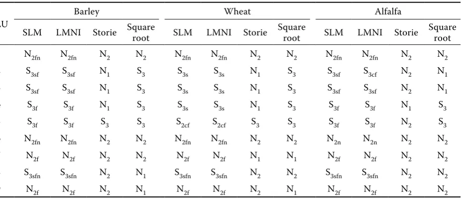
Table 4. Land suitability classes in the study area for barley, wheat and alfalfa based on different methods
LU Barley Wheat Alfalfa
SLM LMNI Storie Square root SLM LMNI Storie Square root SLM LMNI Storie Square root
1 N2fn N2fn N2 N2 N2fn N2fn N2 N2 N2fn N2fn N2 N2 2 S3sf S3sf N1 S3 S3s S3s N1 S3 S3sf S3cf N2 N1 3 S3sf S3sf N1 S3 S3s S3s N1 S3 S3sf S3sf N2 N1 4 S3f S3f N1 S3 S3s S3s N1 S3 S3f S3f N1 S3 5 S3f S3f S3 S3 S2cf S2cf S3 S3 S3f S3f N2 S3 6 N2fn N2fn N2 N2 N2fn N2fn N2 N2 N2n N2n N2 N2 7 N2f N2f N2 N2 N2f N2f N1 N1 N2f N2f N2 N2 8 S3sfn S3sfn N2 N1 S3sfn S3sfn N2 N2 S3sfn S3sfn N2 N2 9 N2f N2f N2 N1 N2f N2f N2 N1 N2f N2f N2 N2
and the influence of soil and site characteristics upon the crop. The identification and delineation of land with desirable attributes are two important stages in finding a land suitable for a specific crop. In this study, after analyzing soil samples, the require-ments of wheat, barely, alfalfa, maize and safflower, summarised by Sys et al. (1993) were used. Then the simple limitation method (SLM), the limitation method regarding number and intensity (LMNI), and the parametric methods (the Storie and the square-root methods) were employed. The classes of land suitability were determined (S1 or highly suitable with production of 80–100% of optimum, S2 or moderately suitable or 60 to 80% of optimum, S3 or marginally suitable or 40–60% of optimum and N or non suitable (N1 & N2)). Economic factors were excluded and moderate level of management was assumed. The evaluations based on SLM and LMNI resulted in similar land suitability classes, which, however, differed from those obtained with the parametric square-root method, if the levels of limitations were high. The results obtained by the parametric square-root method are probably more realistic, as suggested by comparison with other reports (Movahhedi Naeni 1993; Ghasemi Dehkordi 1994; Sarvari & Mahmoudi 2001; Ja-farzadeh & Atabakazar 2004; JaJa-farzadeh et al. 2005a, b; Jafarzadeh & Abbasi 2006; Shahbazi & Jafarzadeh 2004) in which different methods were applied in different parts of country for the same crops. The parametric square-root method suggests that the region of the Bilverdy research
station possesses optimal climatic condition for irrigated barley and safflower, indicating for this case a high suitability class (S1), while the climatic conditions during the growing cycle make the region only moderately (S2) or marginally (S3) suitable for wheat, alfalfa and maize. The soil attributes such as pH, organic matter, gravel content, salinity and alkalinity, taken either alone or in combination, have an influence on the land suitability for barley, wheat, alfalfa, maize and safflower. The results of evaluation of soil properties suggest that the lands in the regions belong to land classes between marginally suitable (S3) and non-suitable (N2). This result can be obtained by either of the two limitation methods (SLM or LMNI) and also by the parametric square-root method. The Storie method suggests that practically all lands belong to the non-suitable (N1–N2) classes (Tables 4 and 5), which, however, is an unrealistic result. The square-root method indicates that the lands are non-suitable (N1–N2) for maize only. Based on the results (especially those from the square-root method), the priority crops for the area studied turn to be wheat (first), barley (second), alfalfa and safflower (third), for which the region belongs to the marginally suit-able class. These crops can yield 40–65% of their optimal production.
CONCLUSION
In general, the area is highly suitable (S1) from the climatic point of view (c) for safflower,
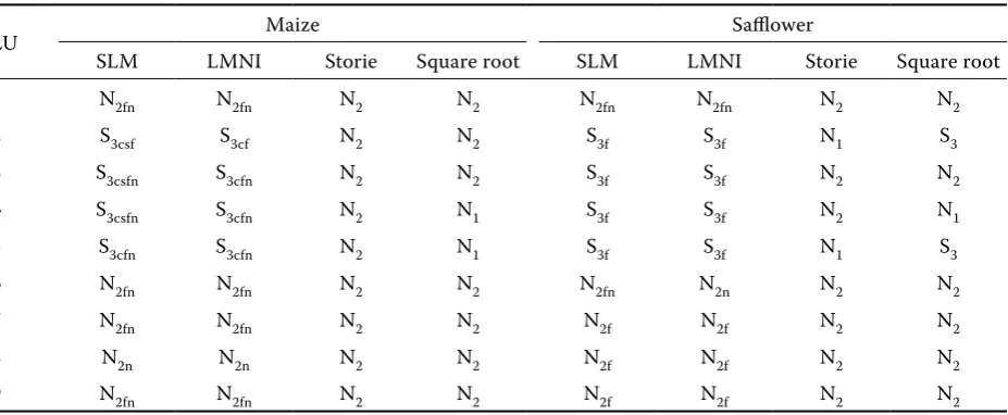
mod-Table 5. Land suitability classes of the study area for maize and safflower based on different methods
LU Maize Safflower
SLM LMNI Storie Square root SLM LMNI Storie Square root 1 N2fn N2fn N2 N2 N2fn N2fn N2 N2 2 S3csf S3cf N2 N2 S3f S3f N1 S3
3 S3csfn S3cfn N2 N2 S3f S3f N2 N2
4 S3csfn S3cfn N2 N1 S3f S3f N2 N1
5 S3cfn S3cfn N2 N1 S3f S3f N1 S3 6 N2fn N2fn N2 N2 N2fn N2n N2 N2 7 N2fn N2fn N2 N2 N2f N2f N2 N2
8 N2n N2n N2 N2 N2f N2f N2 N2
9 N2fn N2fn N2 N2 N2f N2f N2 N2
[image:6.595.68.532.100.291.2]erately suitable (S2) for wheat, barley and alfalfa and marginally suitable (S3) for maize. However, the soil fertility characteristics (f), the salinity and alkalinity conditions (n) and, in some cases, the soil physical characteristics (s) make the lands in the area marginally suitable (S3) or even non-suit-able. Based on these results (especially on those obtained with the parametric square-root method, which seems to be the best), the cultivation of ir-rigated wheat and barley can be recommended, but the majority of the region is non-suitable for maize and alfalfa with safflower. Limitations are posed mainly by the high gravel content, high pH, low organic matter and high salinity and alkalin-ity, either alone or in combination. The picture is principally same for all soil suborders (Cambids or Calcids) and great groups (Haplocambids or Haplocalcids) in the area.
References
Alamdari P. (2004): Qualitative land suitability evaluation of Khajeh research station for wheat, barley, alfalfa, maize and safflower. [M.Sc. Thesis.] Faculty of Agriculture, Soil Science Department, University of Tabriz.
Banaei M.H. (ed.) (1998): Soil Moisture and Tempera-ture Regimes Map of Iran. Soil and Water Research Institute, Ministry of Agriculture of Iran.
FAO (1976): A Framework for Land Evaluation. FAO Soils Bulletin 32, FAO, Rome.
FAO (1983): Guidelines: Land Evaluation for Rainfed Agriculture. FAO Soils Bulletin 52, FAO, Rome. FAO (1991): Production Yearbook. Vol. 45, FAO,
Rome.
Ghasemi Dehkordi V.R. (1994): Soil study and land suitability evaluation, Barkhar region of Isfahan. [M.Sc. Thesis.] Faculty of Agriculture, Soil Science Depart-ment, Tehran University.
Jafarzadeh A.A., Atabakazar M.R. (2004): Land suitability evaluation of Shakaryazi region for wheat, barley, alfalfa, sugar beet and safflower. In: Int. Conf. CIGR. Collection of Extended Abstracts, Beijing, Vol. 2, IV–71.
Jafarzadeh A.A., Abbasi G. (2006): Qualitative land suitability evaluation for the growth of onion, potato, maize, and alfalfa on soils of the Khalat pushan research station. Biologia, 61 (Suppl. 19): S349–S352.
Jafarzadeh A.A, Khoshzaman T., Neyshabouri M.R., Shahbazi F. (2005a): Qualitative land suitabi-lity in Yakhfarvazan region of Ahar for wheat, barley, safflower, bean, soybean and potato. In: Int. Conf. ICEM. Hyderabad, 342–348.
Jafarzadeh A.A., Momtaz H.R., Neyshabouri M.R. (2005b): Qualitative evaluation of land in Karkaj research station of Tabriz University for wheat, potato, maize, tomato, bean and alfalfa. In: Int. Conf. ICEM. Hyderabad, 95–102.
Khiddir S.M. (1986): A statistical approach in the use of parametric systems applied to the FAO framework for land evaluation. [Ph.D. Thesis.] State University Ghent.
Movahhedi Naeni S.A.R. (1993): Land suitability eva-luation of Gorghan area for main agricultural crops. [M.Sc. Thesis.] Faculty of Agriculture, Soil Science Department, Tarbiat Modarres University.
Osie B.A. (1993): Evaluation of some soils in south-wes-tern Nigeria for arable crop production. Communicati-ons in Soil Science and Plant Analysis, 24: 757–773. Saedi S., Jafarzadeh A.A. (2004): Land and soil
detai-led survey of Khajeh Research Station. [Final report.] Islamic Azad University of Tabriz.
Saedi S., Jafarzadeh A.A., Birounara A., Taghi-pour T. (2005): Detailed survey and soil classification of Bilverdy Research Station. Tabriz Islamic Azad University.
Sarvari S.A., Mahmoudi S.H. (2001): Qualitative land suitability evaluation for irrigated sugar beet in Ghaz-vin region. Iranian Journal of Soil and Water (Special Issue), 15: 66–75.
Shahbazi F., Jafarzadeh A.A. (2004): Qualitative evaluation of land suitability in Khushe Mehr region of Bonab for wheat, barley, alfalfa, onion, sugar beet and maize. Agricultural Science, 14: 67–85.
Soil Survey Staff (1993): Soil Survey Manual. Agricultural Handbook No. 18., U.S. Department of Agriculture – Soil Conservation Service, Washington, DC. Soil Survey Staff (2006): Keys to Soil Taxonomy, 10th Ed.,
U.S. Department of Agriculture – Natural Resources Conservation Service, Washington, DC.
Storie R.E. (1976): Storie Index Soil Rating (revised 1978). Spec. Publ. Div. Agric. Sci. No. 3203, University of California, Berkeley.
Sys C., Verheye W. (1974): Land evaluation for irrigation of arid regions by the use of the parameteric method. In: Transactions of 10th Int. Congress of Soil Science.
Moscow, Vol. 10, 149–155.
Sys C., Van Ranst E., Debaveye J. (1991a): Land evaluation. Part I: Principles in Land Evaluation and Crop Production Calculations. Agric. Pub. No. 7, General Administration for Development Cooperation, Brussels.
Sys C., Van Ranst E., Debaveye J. (1993): Land evalua-tion. Part III: Crop Requirements. Agric. Pub. No. 7, General Administration for Development Cooperation, Brussels.
Vink A.P.A. (1960): Qualitative aspect of land classifi-cation. In: Transactions of the 7th Int. Congress of Soil
Science. Madison, Vol. 4, 371–378.
Corresponding author:
Dr. Ali Asghar Jafarzadeh, University of Tabriz, Faculty of Agriculture, Department of Soil Science, 51664 Iran