© 2019, IRJET | Impact Factor value: 7.211 | ISO 9001:2008 Certified Journal | Page 2964
Location based Mobile Multimedia Pusher System
Amit Chaurasia
1, Yash Chaurasia
2, Vishal Gupta
3, Ashwani Singh
4, Vaishali Malpe
51,2,3,4B. Tech, Department of Computer Science, Terna Engineering College, Maharashtra, India 5Assistant Professor, Department of Computer Engineering, Terna Engineering College, Maharashtra, India
---***---Abstract -In today’s generation internet drives the diversification of internet applications. As communication operators widely produce wireless mobile communication networks, the public can access network services if they are within the wireless signal range of mobile base stations. Therefore, a mobile device with computing process ability can allow access to a ubiquitous network via mobile communication network. The Android operating system released from Google allows users to modify source code freely, hence facilitating the development of software applications and improving user interface and performance. Such free access can provide safety to developer’s rights, and thus, it has commercial value. Based on the Android phone, this study proposed the design and implementation of LBMMPS (Location Based Mobile Multimedia Pusher System), which pushes incident multimedia content to friends online in real time. People can share videos, photos, and messages with other friends online in real time. By using GPS coordinates of incidents into Google Map, users can indicate the location where an incident occurs via a map interface. This application LBMMPS records the location of a moving trajectory of a special incident and shows the incident’s movements on the map.
Key Words: Android, Multimedia Pusher, Google Map
Location based Services.
1. INTRODUCTION
Increase in mobile data network bandwidth promotes the development of multimedia network applications. Compared with conventional e-commerce, multimedia video services deliver richer video information. The integration of mobile communication networks and mobile devices allow network video services to be rapidly fused with daily life. Android is an open platform of mobile apparatus development, which architecture mainly consists of an application layer, a mediation layer, and a Linux kernel, which features open source code that allows developers to freely modify source code and improve user interface and performance. In terms of authorization, Apache Software License (ASL) is employed in the mediation and application layers, allowing developers to modify
open source code and freely expand without releasing the modified source code. As a result, the manufacturer can reserve research achievements and improve commercial value. This study employs the latest Android mobile phone open platform, coupled with a mobile communication network, and designs a LBMMPS (Mobile Multimedia Pusher System), which provides real time multimedia sharing and a connected interactive platform.
2. RELATED WORK
In terms of academic research, numerous scholars have researched Android and mobile computing. Shu et al. [1] employed the Android platform to design and implement LBS (Location-based Service) and suggested that the Android platform is applicable to LBS development. Kumar et al. [2] indicated that, because of open source codes and supporting critical web browser and GPS services, the Android coupled with a mobile communication network and a camera could apply be applied to LBS and provide a good environment for GIS application developers. Chang [3] combined OSGi and the Android platform to study a vehicle network management system, which could aid road centers in remote diagnosis and vehicle management. Whipple [4] built a working application to evaluate the capabilities of Android platform. They combined the GPS receiver and the Google Map to prove that the Android smartphone could apply to public safety problems. With the help of Firebase system, it is very easy and handy produce such application at very fast rate. Recently the development in the google map and geolocation has provide a large field to explore the technologies in geolocation. It provides street maps, satellite photos, aerial photography,3600 panoramic views of street (Street View), real-time traffic conditions (Google Traffic), and route planning for travelling by foot, car, bicycle and air or public transportation.
3. DESIGN OF LBMMPS
A. Application Scenario
© 2019, IRJET | Impact Factor value: 7.211 | ISO 9001:2008 Certified Journal | Page 2965 could not join this trip because she had to attend a
qualification exam. Thus, Joe uses LBMMPS to push videos, photos, and messages about sightseeing in Taiwan during his travel, to share with Mary in real time. In the Map mode, Mary could know the location of these multimedia content Joe problems.
B. System Function
LBMMPS provides connected interaction to enable real- time sharing of image content with connected friends, and Location-based Services can be provided through keyword searches of browsed content and flexible shared GPS coordinates, according to geographic location and the time axis concept. LBMMPS is featured in real-time active pushing of video, the content includes captured movies, and photo text information can be actively pushed in real time to connected friends. As the mobile phone transmits content to share with other mobile phones, the mobile phone end requires a high load computing capability and network bandwidth. Hence, if transferred via the server end, LBMMPS-based architecture can reduce mobile phone load. In addition, when the mobile phone end is uploading file content, the LBMMPS system will instantly obtain the GPS location and time, and records in the server along with the file. Thus, other connected friends can browse via the Google MAP interface or search according to time or keyword. LBMMPS connected users can send video content, complete articles, or text messages to the server at any time. They can also set file sharing priority, where, the higher priority connected friends can receive notice, view content shared by friends, and interact with the content publisher in real time.
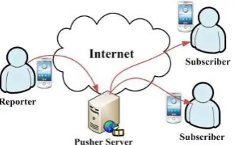
[image:2.595.338.528.334.437.2]C. System Architecture
Figure 1. System architecture of LBMMPS
Figure 1 shows the LBMMPS architecture, when a Reporter captures scenery photos or movies. The Android mobile phone instantly sends the content and
GPS coordinates information to the Pusher Server, then the Pusher Server sends the content to the Subscriber. This system consists of three components, namely, Reporter, Subscriber, and Pusher Server, respectively detailed as follows,
Reporter
Reporter is the multimedia content provider; media object information comes from user-input information text, camera- captured photos, and movies. Incident coordinates are provided by a GPS module. Therefore, a media object consists of the file provider’s information (UserInfo), file priority settings (FriendFlag), incident coordinates (Location), and multimedia content (Content). Priority setting can distinguish priority access of friends from that of other users.
Figure 2. Reporter components
Subscriber
[image:2.595.340.534.571.665.2]Subscriber is the recipient of the multimedia content that can receive multimedia content and interact with the content provider through messages, while the pusher server notification system provides text messages or e-mails.
[image:2.595.80.246.589.692.2]© 2019, IRJET | Impact Factor value: 7.211 | ISO 9001:2008 Certified Journal | Page 2966 Pusher Server
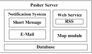
[image:3.595.65.252.194.305.2]The Pusher Server provides the mediation service between Reporter and Subscriber, including storing the Reporters- provided multimedia content and a Notification system that notifies subscribers to view multimedia content.
[image:3.595.37.290.461.582.2]Figure 4. Pusher Server components
Figure 5 shows content sharing flow of LBMMPS. After authentication, the Reporter may shoot multimedia content at any time. By pre-setting sharing priority prior to sending the content, Pusher server notifies Subscribers by pushing text messages and pulling e-mails, according to connected friends classification status. Subscribers can obtain and watch multimedia content and make comments.
Figure 5. Content delivery in Push and Pull mode
4. IMPLEMENTATION OF LBMMPS
This section outlines the system implementation details and software/hardware requirements.
A. System Environment
Table 1 shows the main software/hardware information of LBMMPS, where, the Pusher server is built on a Firebase Database system. Hardware consists of 8-cores CPU, 9,216MB memory, and 2,000GB HDD. A
Firebase web server provides the GUI based on web service, the GUI is developed in XML. LBMMPS provides SSL authentication services.
Table -1: System hardware/software
Pusher Server
OS Linux Distribution, Debian R5
CPU Intel(R) Xeon(R) CPU, E5405, 2.00GHz, 8 Cores
Memory 1024*9 (MB)
Storage Hard Disk 2,000 (GB)
Web
Server Firebase Web Server
Database Firebase Realtime Database 2.0
XML XML 5.2.6-1+lenny3
Mobile
Phone HTC Magic model
Pusher
Client Android SDK 1.5 Release 3
B. Function of LBMMPS
LBMMPS system includes a Reporter/Subscriber and Pusher server, a GPS module to obtain the GPS coordinates of the Reporter and provides the pusher server the video data content. Based on the friend relationship, the Notification System decides to actively push text messages or pull e-mails to notify subscribers. When a friend receives a text message notice, the Android mobile phone text message listening program will determine if it is for control purposes. If yes, then a pop-up window will notify subscribers. Through text messages of the notification system, a Subscriber can directly watch the shared video pushed through the Android mobile phone. If using a desktop computer or notebook, the subscriber can also use the services via their Internet services.
5. DEMONSTRATION OF LBMMPS
A. Connect Interaction
To enhance interaction among system users, a connect interaction function is provided for users to manage friends.
B. Content Filter
© 2019, IRJET | Impact Factor value: 7.211 | ISO 9001:2008 Certified Journal | Page 2967 categories, such as information, photo, or movie. The
object filter enables choices of information to view, according to object, such as friend or individual. Users can also employ the keyword search method to filter information.
C. Browse Information
Browse Information is used to determine which user the information comes from and shows the replies of other users, location of interface provided for the logged-in user to reply, delete, add a friend, update, and logout.
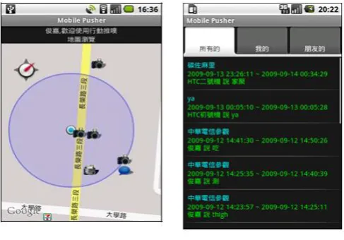
D. Search in Map Mode
[image:4.595.316.555.97.253.2]For a more visual data search, a user can employ Google Map, and use the map browse method to check information, photo or video data. In Figure 6, the small compass in the left upper corner points to the north, and the blue point in the center represents the current location. Users can click on any icon of dialog information, camera, or video camera to content.
Figure 6. Map mode Figure 7. Time-axis mode
E. GPS Tracker
Users can choose to record the GPS coordinates at the start of the journey, and automatically upload the GPS coordinates to the Pusher Server at a regular time interval. They can also plot a path according to path coordinates, and choose to add sharing information, photos, and movies to the path. The figure below shows one path record.
Figure 8. Photo mode Figure 9. GPS tracker
6. CONCLUSION
This study designed a LBMMPS on the Android platform, and provided ubiquitous service through a mobile communication network, in order to push incident multimedia information content to friends. To provide Location-based Service closer to the user, the system combines GPS coordinates and Google Map services when recording an incident, allowing the user to browse the multimedia content of an incident, while it is happening through the Map Interface of Google Map. In the future, this research team will integrate real-time streaming services and mobile digital TV system in order to provide diversified multimedia content.
REFERENCES
[1] Xianhua Shu, Zhenjun Du and Rong Chen, “Research on Mobile Location Service Design Based on Android”, in the 5th International Conference on Wireless Communications, Networking and Mobile Computing, pp. 1-4, 2009. [2] Sandeep Kumar, Mohammed Abdul Qadeer and Archana Gupta, “Location Based Services using Android (LBSOID)”, in the International Conference on Internet Multimedia Services Architecture and Applications (IMSAA), pp. 1-5, 2009.
[3] Teng-Wen Chang, “Android/OSGi-based Vehicular Network Management System”, in the 12th International Conference on Advanced Communication Technology (ICACT), pp. 1644-1649, 2010.
[image:4.595.40.284.412.582.2]© 2019, IRJET | Impact Factor value: 7.211 | ISO 9001:2008 Certified Journal | Page 2968 Systems, Man, and Cybernetics (SMC), pp.
2059-2061, 2009.
[5] Debian, http://www.debian.org.
[6] Google Map, http://maps.google.com.tw. [7] Android, http://developer.android.com.
[8] Yu, C.L., Collection of Google Android SDK Development Paradigms, Delight Press, 2009. [9] Gasolin, Google! Android mobile phone