ISSN: 2334-2986 (Print), 2334-2994 (Online) Copyright © The Author(s). All Rights Reserved. Published by American Research Institute for Policy Development DOI: 10.15640/jea.v4n2a12 URL: https://doi.org/10.15640/jea.v4n2a12
Learning from Seaside`s Master Plan
Adilson Costa Macedo1
Abstract
Review the design of Seaside, an unincorporated master-planned community in Florida, USA, brings to light issues related to rethinking design standards and how people appropriate public spaces. It includes urban and building patterns found in traditional American towns and cities. Characteristics that were not a novelty in the years 1970 when the design of Seaside was conceived. The interest resides into the way the urban tissue was framed using the old patterns and the garden cities principles. This monograph is concerned with the basic diagram used for the town design that cannot be considered as a good one. Nowadays, at summer time, observing the Town Central Square crowded with people, cars parked and many cars passing by on the town access road brings to discussion a critical approach to such diagrams. The thinking sequence related to this context comes from the analysis of the area, particularly the proximity between the regional road and Central Square..
Keywords: Smart Growth, New Urbanism, Resort Town, Urban Design, Urban Morphology
1. Preliminary Assumptions
This monograph addresses issues relating to the origins of Seaside’s urban design, its development, and its establishment as a community, forty years after construction started. It is a case study based on secondary sources (books, magazines and the internet), the author’s visit to the site, as well as experience from observing other small American towns. It expresses the concern explained by author about the fragility of the plan for Seaside, as it relates to the use of the neighborhood model designed by Clarence Stein in 1929, to a context. of late XX Century.
The study is organized sequentially, based on general information on the location, an account by those responsible for the project, short process description, and comments on the master plan and final conclusions. For a description of the project, the guidelines used by William Lennertz were adopted, as laid out in the chapter entitled “town-making fundamentals” from Towns and Town-Making Principles.(Duany; Plater-Zyberk, 2006). The description begins by identifying the origins of the project, after the master plan conclusion. These include the road network, walkways, the regulatory blueprint (zones for integrated activities), the distribution of public buildings and squares, ordinances (directives, supporting elements for project’s implementation), and the actual implementation of the project (putting the plan into practice). The description of the Seaside project follows the same procedures used by American architects for developing the urban design of an entire town or infilling projects in large cities.
The charrette – an intense period of design activity consisting of a series of initial meetings involving all parties interested in the project as a means of allowing architects to gain a consensual basis for their proposals – was peculiar to Seaside. The charrette itself, as a process of design-aid, is not analyzed in this text: this study focuses on the pattern of urban tissue. In this case, Architecture is considered responsible for both site plans and built volumes, regardless of any consideration on architectural styles. As the main feature monograph shows the influence of Clarence Stein’s diagram (1929) for a neighborhood onto Duany’s design for Seaside proposed around fifty years later.
2. The site
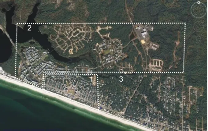
The town of Seaside is situated in Santa Rosa Beach, Walton County, Northwest Florida, a spot on the Gulf of Mexico’s panhandle. Walton County spreads on a peninsula separating the Gulf of Mexico from Choctawhatchee Bay. Seaside is a regional community, with access from Florida State Road Hwy30A, between Fort Walton Beach and Panama City. It occupies an area of 80 acres,with a population of around2,000 (2010 official data). Construction began in 1978 and it was inaugurated in 1982.It stretches for about 1,000 meters along the Santa Rosa Beach waterfront and borders the community of Watercolor to the North and East and Seagrove Beach to the South. Construction of neighboring Watercolor began in 1997 and was completed in 2008. This new community has capitalized on the status of the location and the increase in property prices that Seaside brought to the coastline of Walton County. It comprises an
area of 201.90 acres and can house up to 15,000 residents.i The aerial photograph shows the limits of
Seaside and its proximity to Watercolor. Figure 1 indicates Seaside (1), Watercolor (2), and other landowners (3).
Figure 1: Seaside and Watercolor boundaries Source – Google Earth, 03.14.2008 and Author
3. Building a new community
houses would be conceived as wooden cottages, with the design inspired by similar settlements located in the South of Florida. Davis was a renowned real estate entrepreneur, with an academic background in History and Business Management from Harvard. Seaside was built on a tract of land he received as inheritance from his father. His interest was to create a community reliving the lifestyle from the traditional towns. These principles were shared by his wife, Daryl Davis, who actively participated in the historical research for the venture [Katz,1993].
At the beginning, expectations for this venture were modest: the construction of cottages to form a summer vacation resort. With this idea in mind, they contacted Andres Duany and his wife Elizabeth Plater-Zyberk, a couple of Miami architects renowned for working on residential projects that made use of traditional American architectural styles. They were also professors at the University of Miami, School of
Architecture, and founding partners of the firm DPZ Architects & Town Planners.ii Once DPZ had been
hired, the Davis couple joined the architects in travelling around the state in order to broaden their knowledge about the typical architectural styles in the state of Florida and to observe small communities where there was a degree of centralization of commerce, services and institutions that could be easily accessed on foot by residents [Fulton, 2000].
In his “community-resort”, Davis imagined a place where residents could leave their cars at home and use bicycles or small electrical vehicles. The streets were to be lined with low wooden fences, the houses were to have the traditional front porches, rather than the now-usual garage and yard to park or maneuver vehicles, which became the standard format for suburban houses in America from the 1950s onwards. People had to be able to get to and around the center of the town on foot. At a certain moment, Davis's dream started to take the form of a conceptual project, thanks to the input of the architects. This short story, part of the much larger one that is Seaside, is essential to an understanding of the project as a
whole.iiiIt is an issue related to sustainability. It points to the fact that the harmonious unity between the
points of view of the client and the professional is essential for the success of a project, as long as they are followed by correct technical implementation procedures. This fact applies to any professional field, especially architecture. In the town of Seaside, this synergy was a success: an interested client, with a good understanding of the wider world and adequate financial resources on one side and a first-rate architectural
firm on the other.iv
3. Seaside’s urban design concepts
With the evolution of the project, apart from the cottages, other types of construction started to appear as opportunities for developers and challenges to the architects. Individual residences became more diversified, from the type of cottage envisaged at the beginning, to large and luxurious beachfront houses.
In this case the Hwy30A functions as a route through the city, crossing its central area. Institutional buildings have been distributed around several points of the community, thus creating urban reference points and small gathering points. The master plan shows the urbanized stretch between the beach and Hwy 30A, the still incomplete central square, the Lyceum to the left, above the Center. Ruskin Place is right above it, in the North-South axis, and the main sports complex of Seaside is above it, to the right. Figure 2.
Figure 2: The master plan
Source: The Seaside Research Portal. seaside.library.nd.edu 2010
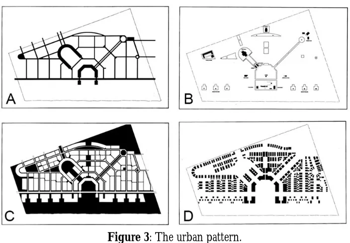
The pattern of the urban tissue is morphologically expressed by the diagrams developed by Duany; Plater-Zyberk. It shows the relative position between the Highway 30A and Main Square that is an issue later discussed in this paper. Figure 3
Figure 3: The urban pattern.
The vehicular system (streets and roads) is described by the authors as reflecting “both the character of the land and the efforts to make a memorable network that will accept future growth in an orderly manner” [Duany et al, 2003]. The master plan makes evident how the local streets go fromHwy30A to an internal ring designed to distribute circulation connecting to the neighboring Watercolor and settlements alongthe highway to the East, Figure 3A.
The civic buildings are spread out onto diverse selected sites in town. They are the town hall, chapel, school, and the tennis club, located inland to stimulate different areas. Six landmarks were built in outstanding positions on the linear low sand hill along the highway. They are small-based and tall, intended to be reference marks on the landscape. Each one is at the point of intersection between the sand dune and the axis of the streets leading inland, “pavilions at the beachfront terminus of each street belong to the residents of these streets” [Duany et al, 2003]. The sequential formation of these pavilions and the visual aspect of the center give Seaside its unique identity, not only for those who circulate around in it, but also for those who view it from the waters of the Gulf (Katz, 1994), Figure 3B.
Regarding the pedestrian movements, it “comprises squares and parks, plus midblock pedestrian paths, which provide the pedestrian routes throughout town, in addition to the sidewalk system” [Duany et al, 2003]. This assumption would be complemented by the notion that people walking on the access streets to the Hwy30A are supposed to cross the highway and continue on the pedestrian path to the seashore, Figure 3C.
The group of blocks, lots and private buildings are designed according to the directives of the Seaside master plan. Local streets define the neighborhood blocks. There are walkways at the back of residential sections, a standard that dates back to traditional urbanism sub-divisions. The site plan is expected to be as defined by the urban designers: The private buildings may be houses, row houses, apartments, shops, offices, lodging or workshops. Building forms are generated by the provisions of a code as interpreted by many designers. Buildings uses are not strictly controlled as in conventional codes but determined by a conjunction of a specified building type and its urban location, Figure 3D. [Duany et.
al, 2003]v
Figure 4: Typical urban block arrangement and a mixed use of Inn and housing.
Source: DPZ. Images Library, 1985. Courtesy of Duany Plater-Zyberk Co. Below, picture by the author, 03.07.2009.
The fabric of private buildings is punctuated by family houses of different sizes permeated with buildings constructed or adapted to be Inns. Figure 4shows the insertion of the building in the urbanized context (street, alley, setbacks, fence, and front porch).For this morphological analysis, these elements would suffice, but the picture also shows the middle class neighborhood character of Seaside: the appearance of people walking (enjoying the holiday-spot atmosphere) and the “Inn by The Sea” sign, by
Vera Bradley.vi
4. About the master plan
Seaside, with its 80 acres and 2,000 residents, would be considered a village, or, at the most, a town, in a morphological classification in accordance with North American standards. There are definitions for hamlet, village, town and city. The word resort defines a place of leisure, outside urban limits. Davis's resort-community, with its diversified land use, has its own administration. Being an unincorporated
community, it is considered a town by the local people.vii
From the study of Seaside master plan comes the analogy with Clarence Stein’s diagram of the neighborhood unit, presented in 1929 as part of the Regional Plan of New York and Environs. In fact, this
notorious diagram was reviewed in the last decade of the 20th Century, providing new patterns for
accessibility, added by Duany, Plater-Zyberk & Company, and furthering the concept of sustainable
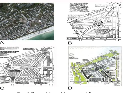
Figure 5: The actual place and three conceptual diagrams.
Source: Google Earth, 11.29.2015 and Wikimedia Commons, 02.23.2016
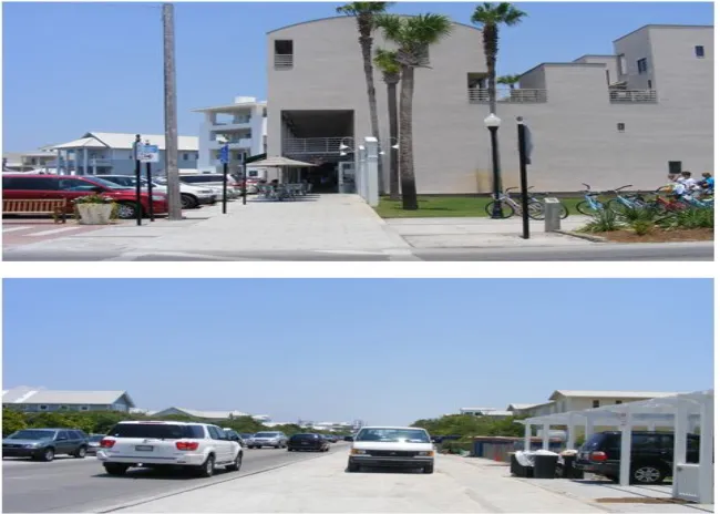
The three diagrams show the neighborhood central square accessible through a crossing road connected to arterial streets. The aerial photo of Seaside highlights its Central Square adjacent to the arterial road, in this case Highway 30A. This design is not comprised in the pattern arrangement suggested by the diagrams. At first, they indicate only a secondary road connecting the regional highway to the neighborhood center; such design guideline is simplified in Seaside, with the highway functioning as access road. In practice, this would mean an amount of vehicular traffic unexpected by the city planners in the late 1970s.Nowadays; the reality is a sequence of new communities facing Hwy30A, such as the neighboring Watercolor, generating a lot of traffic.
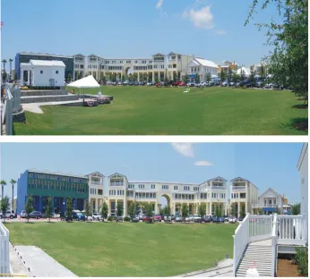
Figure 6: Octagonal shaped commercial arcades characterize the Square Source: Author’s pictures 03.07.2009.
The small white building on the left (Figure 6) is the Post Office, located right on the Central Square visual axis. Directly accessible from the highway, the building was implemented with the purpose
of being an urban reference.ix
The row of commercial buildings in the background forms an octagonal ring all around the Amphitheater lawn; functioning as a visual limit of the square. Figure 6 takes the observer closer to the facades and highlights the different architectural expressions criteria of each lot.
Figure 7: Central Square according to the Krier-Opticosproposition.
Source: Opticos Design Inc image file, 2005.
It is possible to notice the Dreamland Heights Hotel in Figure 8 sited as the second building in
façade of Amphitheater.xThe main entrance to the building, sketched in sequence and facing Hwy 30A,
would be part of the complex bordering the highway: Figure 8shows the lot reserved for this improvement. The picture also highlights the traffic volume, giving an idea of what happens in a summer vacation day.
Figure 8: Blind façade, grassy terrain awaiting new building on a busy road
From these remarks is important characterize Seaside as an entity separated by Hwy30A into two quite different parts: one near the ocean and another across the highway. The former was planned as a set of lots facing the sea, properties big enough to shelter large houses, naturally stimulated by market value related to this particular place. Along the highways, either housing or commercial buildings were located across from the Central Square. Across the highway, the boarding corridor is occupied by the housing blocks and the main square frontage. From this linear pattern the Town grows inland. The urban tissue is
controlled by a form-based code which started in Seaside and was further improved by DPZ architects.xi
5. Conclusion
The Town of Seaside was designed and constructed with great attention to detail: its small size favored the implementation process. It was conceived according to the strategy used by Davis to create a pleasant location in a region that was not a well-known tourist destination, at the time. Attaining a high level of quality in regards to the constructed space was part of Davis's strategy as an entrepreneur. And the process was certainly encouraged by Duany and Plater-Zyberk. Davis brought his dream to fruition by constructing a unique location in the Florida panhandle (Dutton, 2000).As previously stated, Seaside’s construction was very detail-oriented. It is a small, village-like town, controlled by the circumstances of its establishment. It was conceived according to the strategy used by Davis to create a pleasant location in a region not yet recognized as a tourist destination.
Davis's enthusiasm with the originality that the components of traditional American towns could bestow upon Seaside, and other similar communities, led to the foundation of The Seaside Institute (1982). The Institute started organizing seminars to direct project guidelines and discuss the theory and practice of New Urbanism and Smart Growth (Dutton, 2000). It is an indicator of the devotion to the town project and the concern with control over its urban tissue. This goal was made possible due to the town’s reduced size and the premises about urban morphology that were adopted from the beginning. With an urbanistic style and building systematizing view, architect Leon Krier was invited as project consultant. Along with Krier, Opticos Design Inc. from Berkeley, California, was hired to organize a unified land development ordinance template for planning and urban design, known as the Smart Code, for the construction of Seaside. Up to now this code has been systematically reviewed and published as the Smart Code & Manual.
The charrette is an on-site event, held where the project is to be implemented. In the Seaside project, the two most experienced professionals from DPZ participated and were aided by others with less experience, in conjunction with technicians from Walton County, landscape architects, historians, engineers, ecologists, economists and specialists from the real estate market. "The charrette began with a visiting day to the location of the future community and neighboring towns that could serve as inspiration and an introduction to planning and project principles.
Typically, in the following days, the team, together with the client, works day and night, frequently meeting with representatives from public entities and independent advocacy groups in defense of local interests. They make tentative drawings of everything, from the master plan to concepts of typical buildings, including codes, and specific open areas" (Lennertz, in Duany 1991). Surely, since it is a project for a new community, there are no specific groups from the location itself, as mentioned by Lennertz, referring to a generic case. Following this process, the professionals from the firm in charge of the community plan work intensely using data and physical models created during the initial part of the charrette. The authors’ concepts merge with the ideas resulting from the event. Once the process is over, a public presentation of the results is given on the last night, and, in the case of Seaside, it included around forty drawing boards. According to Lennertz, in the end, consensus is achieved on the majority of directives.
This wide-ranging initial discussion process on what the community should look like is enough to stimulate a sense of community early on. The Seaside plan followed the precepts of a so-called a planned community, integrating standards of the physical space with management capacity. As there was no zoning law in Walton County, no difficulties arose to institute the urban ordinance code as proposed by DPZ and other consultants. Another initiative by the community and Robert Davis, through The Seaside Institute, was to define it as an unincorporated community. This meant not having its own administration, thus remaining part of a larger territorial division, in this case, Walton County.
Even though over thirty-five years have passed since it was inaugurated, it is interesting to observe that the Center of Seaside is still not complete. Projects are undertaken by renowned architects and work signed by Steven Holl, Machado & Silvetti, and Leon Krier – Opticos can be seen around the Center. The very high standards demanded by the community regarding the physical premises of the establishments around the Central Square drove lot prices up.This resulted in interesting – from an urban form point of view –plots around the Central Square remaining vacant.
Despite the questioning background raised by the monograph, the Town of Seaside has undoubtedly earned its position in the USA as an important landmark for the New Urbanism movement.
References
Calthorpe, P. & Fulton W. (2001).Theregionalcity: planning for the end of sprawl (1sted). Washington DC: Island
Press.
Duany, A.&Plater-Zyberk, E.&Alminana, R. (2003). The new civic art, elements of town planning. New York: Rizzoli.
Duany A. &Plater- Zyberk, E. (2006) Towns and town making principles. New York: Rizzoli.
Duany, A. Wright, WSortien S. (2006) Smart code & manual, V8 New Urban Publications Inc. New York. Dutton, J.A. (2000). New american urbanism, re-forming the suburban metropolis. Milão: Skira.
Gindroz, Raymond L. (2003). The urban design handbook: techniques and working methods. Pittsburgh: W. W. Norton,
Krier, L. (1998). Architecture: Choice or Faith. London. Andreas Papadakis Publishers,
Leccese, M &Mccormick, K. (2000).Charter of the New Urbanism.Congress for the New Urbanism. New York: McGraw-Hill.
Lennertz, W. (2006). The charrete handbook: the essential guide for accelerated, collaborative community planning“. New York:American Planning Association, ASSN Publishers.
Macedo, A. C. A Carta do Novo Urbanismo Norte-Americano (2007).São Paulo, Revista Integração, 48, 24-32: Universidade São Judas Tadeu
Parolek, D; Karen; C; Paul C(2008). Form-Based Codes, a guide for planners, urban designers, municipalities and developers. New York:Wiley.
Szold, T; Carbonell, A (2002). Smart Growth, Form and Consequences. Cambridge, MA: Lincoln Institute of Land Policy.
Urban Design Associates (2004). The architectural pattern book: a tool for building great neighborhoods. Pittsburgh: W.W. Norton.
Websites
www.opticosdesign.com.html (13. 03.2008) www.zakuski.utsa.edu;krier(19.04.2008) www.com.org;charter( 13.03.2008) www.casestudies.uli.org/ (16.04.2008)
www.urbandesignassociates.com/ (16.04.2008).
iThe quantitative data used was supplied by the Urban Land Institute (ULI) – Development Case Studies. ii The author was in touch with DPZ architectural office in Miami.
iiiReferences found in Dutton and Katz books.
iv The connections between Davis and Duany are presented in the text “Seaside, Florida” taken from the
Everything2 website on 5/27/02.
v The citations regarding Figure 3 were taken from the book The New Civic Art, Elements of Town Planning. viTaken from a Google advertisement: “Vera Bradley is a leader in fashionable, colorful, cotton quilted handbags,
accessories, luggage, and paper and gift items for women of every age”.
viiData from the United States Census Bureau.
viii Figures B, C and D are mentioned in Douglas Farr’s book Sustainable Urbanism, Urban Design with nature. ix The Post Office building was designed by architect Leon Krier.
x The Dream Land Hotel was designed by Steven Holl& Associates and is already built.