www.nat-hazards-earth-syst-sci.net/12/351/2012/ doi:10.5194/nhess-12-351-2012
© Author(s) 2012. CC Attribution 3.0 License.
and Earth
System Sciences
Earthquake-triggered landslides in southwest China
X. L. Chen, Q. Zhou, H. Ran, and R. Dong
Key Laboratory of Active Tectonics and Volcano, China Earthquake Administration, Beijing, 100029, China Correspondence to: X. L. Chen (04chxl@sina.com)
Received: 31 May 2011 – Revised: 4 November 2011 – Accepted: 14 December 2011 – Published: 17 February 2012
Abstract. Southwest China is located in the southeastern
margin of the Tibetan Plateau and it is a region of high seis-mic activity. Historically, strong earthquakes that occurred here usually generated lots of landslides and brought de-structive damages. This paper introduces several earthquake-triggered landslide events in this region and describes their characteristics. Also, the historical data of earthquakes with a magnitude of 7.0 or greater, having occurred in this region, is collected and the relationship between the affected area of landslides and earthquake magnitude is analysed. Based on the study, it can be concluded that strong earthquakes, steep topography as well as fragile geological environment, are the main reasons responsible for serious landslides in southwest China. At the same time, it is found that the re-lationship between the area affected by landslides and the earthquake magnitude in this region are consistent with what has been obtained worldwide. Moreover, in this paper, it is seen that the size of the areas affected by landslides change enormously even under the same earthquake magnitude in the study region. While at the same tectonic place or fault belt, areas affected by landslides presented similar outline and size. This means that local geological conditions and historical earthquake background have an important influ-ence on landslides distribution, and they should be consid-ered when assessing earthquake-triggconsid-ered landslide hazards at Grade 1 according to ISSMGE.
1 Introduction
As a kind of secondary disaster caused by strong earth-quakes, earthquake-triggered landslides have drawn much attention in the world because of severe hazards it causes. In a mountainous region, sometimes a great loss of lives and properties caused by landslides even exceeds the losses caused by the earthquake itself. For example, in the Wenchuan earthquake of 12 May 2008, almost 20 000
fatal-ities were due to landslides triggered by the shaking (Yin et al., 2009; Zhang, 2009). Different from the landslides caused by rainfall, earthquake-triggered landslides can take place in a comparatively wider region, and sometimes they are the most potentially destructive amongst the secondary geotech-nical hazard associated with earthquakes. These large and widely distributed landslides usually cannot be prevented by current mitigating measures, nor can the regular measures used to monitor or predict rainfall-triggered landslides. In-stead, the effective preventive measures are early warning and evacuation of vulnerable communities. In order to mit-igate the damages, researches on the potential earthquake-induced landslide zoning are being conducted in many coun-tries at present (Jibson and Michael, 2009; Scott and Keefer, 2003; National Institute for Land and Infrastructure Man-agement, Ministry of Land, Infrastructure, Transport and Tourism, 2004).
352 X. L. Chen et al.: Earthquake-triggered landslides in southwest China
should be the simplest and most important method in eval-uating earthquake-triggered landslide hazards: the hazard is expressed as a binary function defining geographical limits within which landslides will be expected from an earthquake of specified magnitude and location (Bommer et al., 2002).
In Southwest China, due to its complex geological and geographical conditions, many strong earthquakes occurred frequently and are accompanied by a large number of land-slides that was associated with the serious damage (Yi et al., 2002; Xu et al., 2005; Chen et al., 2010; Wang et al., 2009; Wen et al., 2004). For example, the destruction caused by landslides during Wenchuan Earthquake in China in 2008 was unexpected and shocked the world. This earth-quake not only caused an amount of landslides of more than 15 000 (Yin et al., 2009), also, it triggered some infrequent huge landslides along the seismic faults. Daguangbao land-slide with estimated volume of 750 million m3is the largest one among the individual landslides triggered by Wenchuan earthquake (Huang et al., 2009). Similarly, landslides caused by the Diexi earthquake in 1933 formed a large dam on the Min river, and later this dam collapsed and inundated the downstream region, resulting in thousands of deaths. Ob-viously, as a secondary seismic disaster, earthquake-induced landslides in the southwest China clearly constitute an im-portant factor of the high level seismic risk to which the pop-ulation and fragile environment of this region are exposed.
According to the latest earthquake statistics, there are 835 earthquakes with magnitude 4.7 or greater which oc-curred in the study area (Earthquake Disaster prevention de-partment of State Seismological Bureau, 1995; Earthquake Disaster prevention department of China Earthquake Admin-istration Bureau, 1999). Therefore, the data of landslides which occurred with these earthquakes would enrich the worldwide landslides database. Limited to incompleteness of historical documents, this paper will present just a part of earthquake-triggered landslides in southwest China and de-scribe several earthquakes which triggered many landslides in the modern time and had formal post-earthquake investiga-tions. Despite of imperfect data, earthquake-triggered land-slides of southwest China provided in this paper will supple-ment the previous researches, as well as the worldwide data for a better understanding in landslide hazard. Also, the re-sults obtained in this study will be a preliminary step in fur-thering the study on influencing factors related to landslide hazard assessment at the region scale.
2 Regional setting
The study region called Southwest China is located in the southeastern margin of Tibetan Plateau. This research actu-ally focuses on a slightly larger area from 99–105◦E and 23– 33◦N, which includes the western part of Sichuan province and the eastern part of Yunnan province in China (Fig. 1).
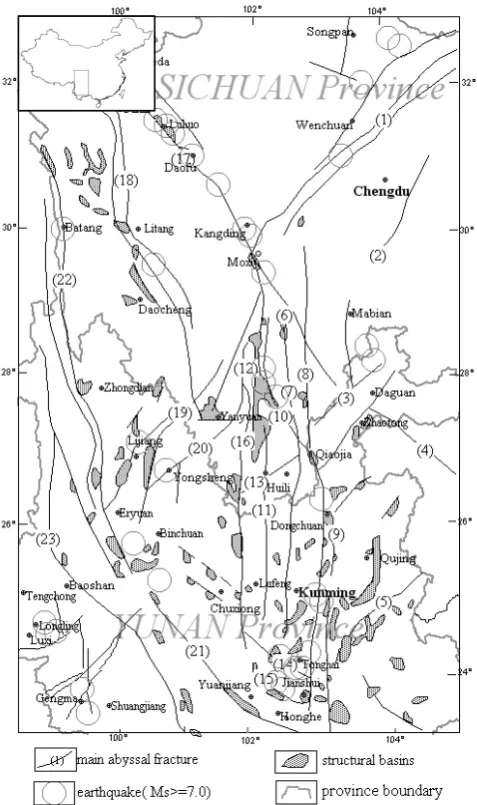
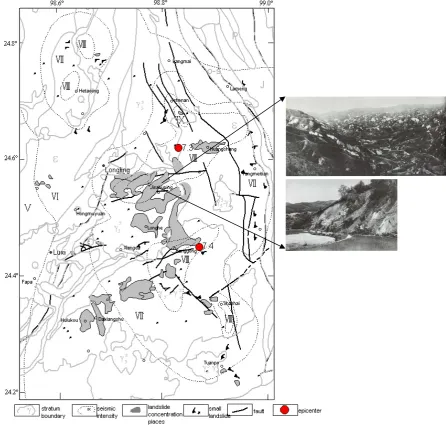
Fig 1. Distribution of the main faults and structural basins in southwest China (revised from Southwest China Intensity Zoning Team of State Seismological Bureau)
(1) Longmenshan fault; (2) Emei-Jinyang fault; (3) Lianfeng-Qiaojia fault; (4) Yiliang-Shuicheng fault; (5) Mile-Shizong fault; (6) Puxionghe fault; (7) Xiluohe fault; (8) Luoxi fault; (9) Xiaojiang fault; (10) Zemuhe fault; (11) Anninghe fault; (12) Nanhe fault; (13) Ninghui fault; (14) Qujiang fault; (15) Shiping-Jianshui fault; (16) Mopanshan-Lvzhijiang fault; (17) Xianshuihe fault; (18) Litang fault; (19) Xiaojinhe fault; (20) Jinhe-Yongsheng-Binchan fault; (21) Yuanjiang fault; (22) Jinshajiang fault; (23) Lancangjiang fault
Fig. 1. Distribution of the main faults and structural basins in
south-west China (revised from Southsouth-west China Intensity Zoning Team of State Seismological Bureau), (1) Longmenshan fault; (2) Emei-Jinyang fault; (3) Lianfeng-Qiaojia fault; (4) Yiliang-Shuicheng fault; (5) Mile-Shizong fault; (6) Puxionghe fault; (7) Xiluohe fault; (8) Luoxi fault; (9) Xiaojiang fault; (10) Zemuhe fault; (11) Anninghe fault; (12) Nanhe fault; (13) Ninghui fault; (14) Qu-jiang fault; (15) Shiping-Jianshui fault; (16) Mopanshan-LvzhiQu-jiang fault; (17) Xianshuihe fault; (18) Litang fault; (19) Xiaojinhe fault; (20) Jinhe-Yongsheng-Binchan fault; (21) Yuanjiang fault; (22) Jin-shajiang fault; (23) Lancangjiang fault.
2.1 Geology and geomorphology
The present structural outline of southwest China has re-sulted from the combination of Indo Sinian orogenesis, Yan-shan detachment movement and the Himalayan thrust nappe movement. From the Cenozoic era, features of the fault blocks, which formed during Indo Sinian orogenesis and
Yanshan movement, had changed due to the extension move-ment of the crust (Southwest China Intensity Zoning Team of State Seismological Bureau, 1985). As a result, there are around one hundred structural basins with various character-istics formed in this region. Also, the fault zones with NS, NE and NW trending directions dominate in this area (Zhang et al., 2003). Generally, the fracture zones are hundreds of kilometres in length, and have a width ranging from 10 km to 30 km. They extend straight and are unaffected by the geomorphology. The fault basins, in general, change from 1 km to 10 km in width and 10–70 km in length, and are dis-tributed mostly along the fault zones (Southwest China In-tensity Zoning Team of State Seismological Bureau, 1985). In southwest China, the contrast between the elevations in this region is remarkable, high mountains always intersects with deep valleys. It is one of the most obvious tectonic fea-tures that deep fracture zones and the fault blocks created by the faults are very well-developed.
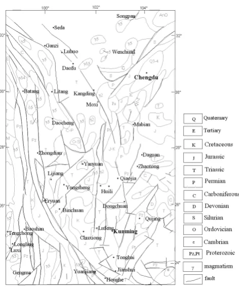
In the seventies of last century, a comprehensive study of earthquake intensity zoning in southwestern China is con-ducted by Southwest China Intensity Zoning Team, State Seismological Bureau of China. In total, there are 23 frac-ture zones with different lengths and trending directions marked in this region (Fig. 1). Among these fracture zones, Anninghe fracture zone and Mopanshan-luzhijiang fracture zone are so typical that they straightly extend in NS direc-tion through this area, with magmatic rocks from different geological periods distributing along them, reflecting strong tectonic movements. During the long geological period, the fracture zones tend to have a significant effect on the advanc-ing depositional history. Blocks adjacent to fracture zones are shown as uplifting with respect to sinking. For instance, the uplift blocks tend to consist of the early Palaeozoic se-quence, while the fault basins are filled with Palaeozoic or Mesozoic formations. Regarding this area as a whole, there is a tendency for the NS fault zones, along which the basins are situated, to show a changeable elevation higher in the north and west with respect to the south and the east; and for the NW fault zones, higher in the northwest with respect to southeast. The variation in elevation for the basins in this re-gion indicates the relationship between the rising of the Tibet Plateau and the subsiding of the basins. From Sinian Period to Quaternary, although almost all kinds of stratum are out-cropped in this place, they have been cut in pieces due to the frequent and strong events which occurred (Fig. 2).
2.2 Seismicity and seismic hazard
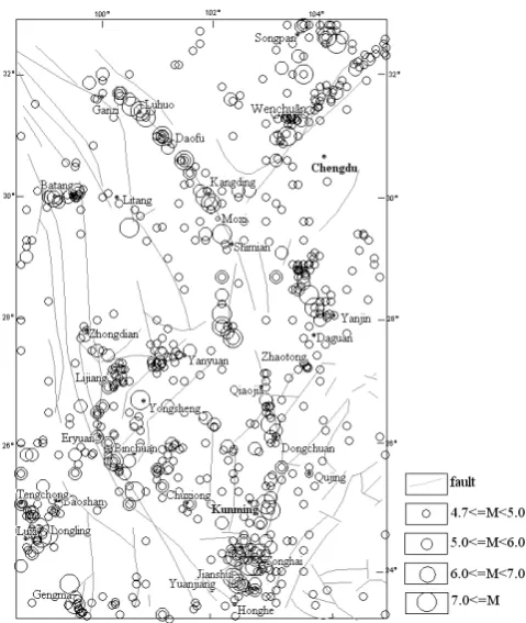
Historically, southwest China is very prone to earthquakes. According to the latest earthquake statistics in the study area, there are 835 earthquakes with magnitude 4.7 or greater, in which there are 119 earthquakes of 6.0≤M <7.0, 35 earth-quakes of 7.0≤M <8.0, and 2 earthquakes of M≥8.0 (Fig. 3, Earthquake-resistant and damage prevention depart-ment of State Seismic Bureau, 1995; Earthquake-resistant
Fig 2. Geological map in southwest China (Revised from Lithospheric dynamics atlas of China, 1989)
2.2 Seismicity and seismic hazard
In history, southwest China is very prone to earthquakes. According to the latest earthquake statistics in the study area, there are 835 earthquakes with magnitude 4.7 or greater, in which there are 119 earthquakes of 6.0≤M<7.0, 35 earthquakes of 7.0≤M<8.0, and 2 earthquakes of M≥8.0 (Fig.3, Earthquake-resistant and damage prevention department of State Seismic Bureau , 1995; Earthquake-resistant and damage prevention department of China Earthquake Administration Bureau, 1999).
Of the two 8.0 earthquakes, one is 2008 Wenchuan earthquake recorded by seismograph instrumentals, the other is located at Songming region in Yunnan province in 1833. The latter’s seismic parameters were obtained by inference from various history records about the
Fig. 2. Geological map in southwest China (Revised from
Litho-spheric dynamics atlas of China, 1989).
and damage prevention department of China Earthquake Ad-ministration Bureau, 1999).
Of the two 8.0 earthquakes, one is the 2008 Wenchuan earthquake recorded by seismograph instrumentals, the other is located at Songming region in Yunnan province in 1833. The latter’s seismic parameters were obtained by inference from various historic records about the damages during this earthquake. Both of these two 8.0 earthquakes caused a huge number of landslides and collapses (Yin et al., 2009; Huang et al., 2009; Wang et al., 2009).
Research and field investigation find out that the strong earthquakes were always generated along the deep frac-ture zones, showing some close relationship between them (Southwest China Intensity Zoning Team of State Seismo-logical Bureau, 1985; Zhang et al., 2003). Moreover, epicen-tres of several shocks are regularly aligned in the same struc-tural zone. For example, at Xianshuihe seismic zone, there are more than 50 earthquakes documented with magnitude 4.7 or greater, in which there are 22 of 6.0 or greater. Espe-cially, there are 4 earthquakes with magnitude 7.0 or greater occurred in this seismic zone since 1900.
354 X. L. Chen et al.: Earthquake-triggered landslides in southwest China
damages during this earthquake. Both of these two 8.0 earthquakes caused a huge number of landslides and collapses (Yin et al, 2009; Huang et al 2009; Wang et al, 2009).
Research and field investigation find out that the strong earthquakes were always generated along the deep fracture zones, showing some close relationship between them (Southwest China Intensity Zoning Team of State Seismological Bureau 1985, Zhang et al, 2003). Moreover, epicenters of several shocks are regularly aligned in the same structural zone. For example, at Xianshuihe seismic zone, there are more than 50 earthquakes documented with magnitude 4.7 or greater, in which there are 22 of 6.0 or greater. Especially, there are 4 earthquakes with magnitude 7.0 or greater occurred in this seismic zone since 1900. Yi and Xu et al studied the features of active tectonics and recurrence behavior characteristics of strong earthquakes in this region, the results showed that the low velocity layers associated with the high conducting layers should be the cause of frequent earthquake occurrence in the upper crust (Yi et al, 2002; Xu et al, 2005).
Fig. 3. Seismicity in southwest China (Revised from Southwest China Intensity Zoning Team of State Seismological Bureau, 1985).
3 Landslides caused by earthquakes in southwest China
3.1 Earthquake database
Reports and documents of earthquake-triggered landslides in southwest China have been collected from a wide vari-ety of source, there are 835 earthquakes with magnitude 4.7 or greater occurred in the study area according to the latest earthquake statistics. Although the records of strong earth-quakes (M >=7.0) dates back to 814 BC, data of the oc-currence of landslides in the events is extremely sparse prior to 1500 (Earthquake-resistant and damage prevention depart-ment of State Seismic Bureau, 1995). Limited to the develop-ment level of economy and culture in southwest China in the past time, not every earthquake which triggered landslides had a detailed investigation and records. As a result there is often uncertainty regarding the source parameters of some of the earlier events and, in particular, focal depths are of-ten poorly determined. Not only in China, it is universal that historical earthquake-triggered landslide data is scarce in the world. The first formal and scientific post-earthquake inves-tigation was undertaken following the earthquake swarm in Calabria, Italy in 1783 (Keefer, 2002). Before it, the his-torical accounts of landslides in earthquakes are typically so incomplete and vague that conclusions based on these ac-counts are of limited usefulness (Keefer, 2002).
Neverthe-less, historical landslide documents are still the important base for the landslides research. Table 1 shows earthquakes with magnitude 7.0 or greater in southwest China.
In southwest China, except for a few earthquakes which occurred in modern times had relatively detailed landslide in-ventory based on field investigations, such as Luohuo quake, Longling earthquake, most of the historical earth-quakes were just simply recorded with the place where the big size landslides occurred. Due to this reason, it is diffi-cult to count the landslide number and to calculate the ar-eas affected by landslides. Fortunately, in the 1990s, Chi-nese Earthquake Administration took charge of collecting and compiling the historical earthquakes catalogue, which was intended to obtain more accurate and reliable informa-tion about seismic parameters such as magnitude, epicen-tre, secondary disasters and so on. As a result of the work, some historical earthquakes could be traced back, then seis-mic intensity lines can be obtained based on history docu-ments and corresponding field works. Although it is still dif-ficult to draw lines enclosing the landslides based on the his-torical earthquake catalogue, the seismic intensity line will help. In this paper, the seismic intensity line of VII is used instead to roughly calculate the area affected by landslides. As to the relationship between seismic intensity and land-slides distribution, it is said that there are many landland-slides which occurred in the area with intensity of VI and even lower according to the publications in recent years (Keefer, 2002, 2006; Jibson, 2000; Qi et al., 2010). But in south-west China, studies of documented historical earthquakes and earthquakes which occurred in modern times show that earthquake-induced landslides are prior to occur more likely to within the area with seismic intensity VII or greater (Qiao et al., 1992; Zhou et al; Yang et al., 2002; Wang et al., 2009; Institute of Geography of Sichuan province, 1973, 1974; Earthquake disaster prevention department of State seismo-logical Bureau, 1995, 1999). Qiao’s study also showed that some earthquake-triggered landslides were mostly concen-trated around the epicentre regions such as the Batang earth-quake in 1870, Diexi earthearth-quake in 1933 and so on (Qiao et al., 1992). Certainly, there are some earthquake-triggered landslides in the area with an intensity line of VI, such as Longling earthquake that will be introduced in this paper later, but the number and size of landslides in these events are far smaller. The difference between the characteristics of landslide distribution in the different regions reveals the influence of local geological and topographic conditions on landslide development. Though sometimes it may underesti-mate the landslide area using the seismic intensity line of VII for calculating the affected area in the study region, consider-ing characteristics of landslide distribution and the limitation of data, it may be an acceptable way to deal with the data.
Table 1. Earthquakes with magnitude 7.0 or greater in southwest China.
Earthquake Date Focal Magnitude Location Epicentre seismic Area affected Reference*
No. (yy-mm-dd) depth (km) Epicentre intensity landslide (km2)
Latitude Longitude
1 814-4-6 27.9 102.2 7 Xichang,Sichuan IX E
2 1216-3-24 28.4 103.8 7 Leibo,Sichuan IX E
3 1500-1-13 24.9 103.1 7 Yiliang,Yunnan >=IX E
4 1515-6-27 26.7 100.7 7.75 Yongsheng,Yunnan X 20 010 E, S
5 1536-3-29 28.1 102.2 7.5 Xichang,Sichuan X E
6 1588-8-9 24 102.8 7 Jianshui,Yunnan >=IX 8843 E, S
7 1652-7-13 25.2 100.6 7 Midu,Yunnan IX+ 4392 E, S
8 1713-9-4 32 103.7 7 Maoxian,Sichuan IX E
9 1725-8-1 30 101.9 7 Kangding,Sichuan IX E
10 1733-8-2 26.3 103.1 7.75 Dongchuan,Yunnan X 15480 E, S
11 1786-6-1 29.9 102 7.75 Kangding,Sichuan E
12 1786-6-10 29.4 102.2 7 Luding,Sichuan E
13 1789-6-7 24.2 102.9 7 Huaning,Yunnan IX+ 8416 E, S
14 1799-8-27 23.8 102.4 7 Shiping,Yunnan IX 5647 E, S
15 1816-12-8 31.4 100.7 7.5 Luhuo, Sichuan X E
16 1833-9-6 25 103 8 Songming,Yunnan >=X 27480 E, S
17 1850-9-12 27.7 102.4 7.5 Xichang,Sichuan X 11 710 E, S
18 1870-4-11 30 99.1 7.25 Batang,Sichuan X E
19 1887-12-16 23.7 102.5 7 Shiping,Yunnan IX+ 2946 E, S
20 1893-8-29 30.6 101.5 7 Daofu,Sichuan IX E
21 1904-8-30 31 101.1 7 Daofu,Sichuan IX E
22 1913-12-21 24.15 102.45 7 Eshan,Yunnan IX 2839 E, S
23 1923-3-24 31.3 100.8 7.3 Luhuo,Sichuan X 1868 E, S
24 1925-3-16 25.7 100.2 7 Dali,Yunnan IX+ 4888 E, S
25 1933-8-25 32 103.7 7.5 Maowen,Sichuan X 7161 E, S
26 1941-5-16 23.7 99.4 7 Gengma,Yunnan IX 2654 E, S
27 1948-5-25 29.5 100.5 7.3 Litang,Sichuan X 6110 E, S
28 1955-4-14 30 101.9 7.5 Kangding,Sichuan X 4416 E, S
29 1970-1-5 13 24 102.7 7.8 Tonghai,Yunnan X+ 8479 E,,ES
30 1973-2-6 11 31.48 100.53 7.6 Luhuo,Sichuan X 409 E, GS, C
31 1974-5-11 14 28.2 103.9 7.1 Daguan,Yunnan IX 610 E,GS
32 1976-5-29 21 24.45 98.87 7.4 Longling,Yunnan IX 3382 E, GS
34 1976-8-16 15 32.61 104.13 7.2 Songpan,Sichuan IX 1991 E, ES
36 1988-11-6 16 23.37 99.5 7.2 Gengma,Yunan X 5966 E, ES
37 1996-2-3 10 27.083 100.267 7 Lijiang,Yunnan IX 8433 E, EY
38 2008-5-12 14 31 103.4 8 Wenchuan,Sichuan XI 21000 N
* E: Earthquake disaster prevention department of China Earthquake Administration (1995, 1999); ES: Earthquake Administration of Sichuan Province; C: Chengdu earthquake investigation team of State seismological Bureau; EY: Earthquake Administration of Yunnan Province; GS: Institute of Geography of Sichuan province; S: Southwest China Intensity Zoning team, State Seismological Bureau; N: National Wenchuan Earthquake experts committee.
3.2 Earthquake-induced landslides
As mentioned before, southwest China is located in the southeastern margin of the Tibetan Plateau. During the tec-tonic evolution, this region experienced tectec-tonic movements many times and today it is still one of the highest seismic-ity regions in China. In addition to the steep topography, earthquake-induced landslide is a kind of common hazard phenomena in this region.
In this paper, 3 earthquakes (Luhuo earthquake in 1973, Zhaotong earthquake in 1974, and Longling earthquake in 1976) will be introduced. These earthquakes occurred in modern time and landslides triggered during the events were recorded comparatively in detail through post-seismic field investigations.
In China, Chinese Seismic Intensity is used widely in the earthquake-triggered landslides research. Table 2 shows the relationship of Chinese Seismic Intensity value and peak ground acceleration.
3.2.1 Luhuo earthquake in 1973
356 X. L. Chen et al.: Earthquake-triggered landslides in southwest China 3.2 earthquake-induced landslides
As mentioned before, southwest China is located at southeastern margin of the Tibetan Plateau. During the tectonic evolution, this region experienced many times of tectonic movements, and today it is still one of high seismicity regions in China. In addition to the steep topography, earthquake-induced landslide is a kind of common hazard phenomena in this region.
In this paper, 3 earthquakes( Luhuo earthquake in 1973, Zhaotong earthquake in 1974, and Longling earthquake in 1976) will be introduced. These earthquakes occurred in modern time and landslides triggered during the events were recorded comparatively in detail through post-seismic field investigations.
In China, Chinese Seismic Intensity is used widely in the earthquake-triggered landslides research. Table 2 shows the relationship of Chinese Seismic Intensity value and peak ground acceleration.
Table 2. Distribution of Peak Ground Acceleration Corresponding to Each of the Chinese Seismic Intensity values (Li et al, 2008)
Chinese seismic Intensity <Ⅵ Ⅵ Ⅶ Ⅷ Ⅸ ≥Ⅹ
Peak Ground Acceleration (gal) 10.0-44.9 45.0-89.9 90.0-177.9 178.0-353.9 354.0-707.9 ≥708.0
3.2.1 Luhuo earthquake in 1973
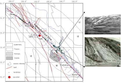
Luhuo earthquake occurred in Luhuo county, Sichuan province, on Feb. 6, 1973. The macroepicenter was located at 31.48°N,100.53°E. Mainshock magnitude is 7.6 with focal depth 11 km. Epicenter seismic intensity is up to Ⅹ(Fig. 4).
Fig. 4. Geological map of Luhuo earthquake area and locations of earthquake-triggered landslides (revised from the Institute of Geography
of Sichuan province. Photos are from the Institute of Geology, State Seismology Bureau).
Table 2. Distribution of Peak Ground Acceleration Corresponding to Each of the Chinese Seismic Intensity values (Li et al., 2008).
Chinese seismic Intensity <VI VI VII VIII IX ≥X
Peak Ground Acceleration (gal) 10.0–44.9 45.0–89.9 90.0–177.9 178.0–353.9 354.0–707.9 ≥708.0
1. Geology and geomorphology
The main affected area of Luhuo earthquake present at Daxueshan Mountain range, with an average elevation of 3800 m. Terrain in this region changes sharply. The Xianshuihe river runs from northwest to southeast along the Xianshuihe fault zone, companied by narrow val-leys alternating with wide valval-leys. At narrow valley, the bank is steep and the river bed gradient is big, while at wide valley, the bank is moderate and river bed gradient is small.
In this area, the outcropped strata are simple, which only include Permian, Triassic and Quaternary System. The lower Permian stratum is mainly composed of lime-stone, while the upper Permian stratum is composed of basalt and shale. The Triassic stratum is some kind of metamorphic flysch formation. The component of Qua-ternary strata is river-terrace gravel layer, which mostly distribute along the Xianshuihe valley.
Field investigation found Xianshuihe fault was the seis-mic fault responsible for Luhuo earthquake. Taking ac-count of fault activity, Xianshuihe fault can be divided into two parts bounded at Moxi: the northwest part of Xianshuihe fault has the character of left-lateral strike-slip fault, while southeast part has the reverse compo-nent (Xu, et al., 2005).
2. Landslides caused in the earthquake
The epicentre region has a profile of 41 km in length, and 4.5 km in width. Within this region, all of the Ti-bet style buildings were collapsed, and the ground crack distributed in groups or belts. Landslides and collapses can be seen everywhere (Fig. 3).
Post-earthquake investigation found that the landslides spatial distribution was controlled by the Xianshuihe fault zone, almost all of the landslides and collapses oc-curred in the Xianshuihe Valley along the faults. The landslide affected area is around 70 km in length along
Table 3. Number of earthquake-induced landslide in different
seis-mic intensity area.
Seismic Number of Percent intensity landslide %
X 96 70.1
IX 37 27.0
VIII 4 2.9
Total 137 100
the valley, and the widest part is less than 2 km. In to-tal, there are 137 landslides recorded by the field inves-tigation group. With the increasing of seismic inten-sity, the number of landslides is increasing. The land-slides distribution in different seismic intensity area is shown in Table 3. Among these 137 landslides, only one landslide occurred in Permian limestone, whereas all of others were found in Quaternary accumulation layer. Statistical studies also show that the favourite range of slope angles for landslides is between 30◦and 50◦degree. All the landslides occurred in the area with seismic intensity above VIII (Institute of Geography of Sichuan province, 1973).
3.2.2 Zhaotong earthquake in 1974
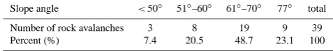
Zhaotong earthquake occurred at the boundary region of Yongshan County and Daguan County of Yunnan province, on 11 May 1974. The macro-epicentre is at the 103.9◦E, 28.2◦N. Mainshock magnitude isMs=7.1 with focal depth
8 km. Epicentre seismic intensity is up to IX (Fig. 5). 1. Geology and geomorphology
The affected area of Zhaotong earthquake is located in the northern part of eastern Yunnan plateau. This re-gion is kind of undulating hills with elevation around 1300∼1800 m. In the study region, almost all of the strata from the Sinian Period to Quaternary period are outcropped. The tectonics in Quaternary system dis-tribute along the rivers, form the river terrace and the river beds.
2. Landslides triggered in this earthquake
Zhaotong earthquake triggered lots of landslides. Most of the landslides occurred in the epicentre region of seismic intensity IX, some distributed in the area with seismic intensity XIII or XII (Fig. 5). Landslides were seldom found beyond these areas. The places where landslides developed usually have steep slope angle 26∼45◦, while rock avalanche can be found at the steeper places and fault fractural zone. Only one land-slide slid along the bedding layer in the Permian lime-stone, whereas all others occurred in the Quaternary
Table 4. Distribution of landslides by slope angle (from Institute of
Geography of Sichuan province).
Slope angle 16◦–25◦ 26◦–35◦ 36◦–45◦ 46◦–55◦ total
Number of landslides 5 4 13 6 28
Percent (%) 17.8 14.3 46.4 21.5 100
Table 5. Distribution of rock avalanches by slope angle(from
Insti-tute of Geography of Sichuan province).
Slope angle <50◦ 51◦–60◦ 61◦–70◦ 77◦ total
Number of rock avalanches 3 8 19 9 39
Percent (%) 7.4 20.5 48.7 23.1 100
residual deposits and deep weathered layer. For rock avalanches, they concentrated in the Permian limestone and Triassic sandshale which are deeply weathered and have developed joints.
Tables 4 and 5 show the relationship between landslides and slope angle, rock avalanches and slope angle, respec-tively; Table 6 shows relationship between landslides, rock avalanches and seismic intensity (Institute of Geography of Sichuan province, 1974).
3.2.3 Longling earthquake in 1976
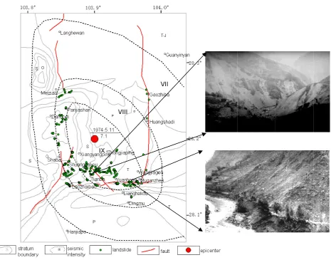
Longling earthquake occurred at Longling County, Yunan province on 29 May 1976. Actually, Longling earthquake contains two mainshocks with magnitude of 7.3 and 7.4. Epicentre of the magnitude 7.3 mainshock is at 98.83◦E, 24.62◦N, and epicentre of the magnitude 7.4 mainshock is at 98.87◦E, 24.45◦N. As a result, there are 2 epicentre seis-mic zones formed with seisseis-mic intensity IX.
1. Geology and geomorphology
The study area is located in the western part of Yunnan province, on the west side of Lancangjiang deep fault zone. It is composed of a series of anticlines, synclines and faults. This region has experienced intense tec-tonic movement, and subjected to frequent severe earth-quakes. Frequent and sustainable magmatic actions re-sulted in magnetite, which formed in different periods from Caledonian and Hercynian to Quaternary. Geo-morphologically, the study region takes on an aspect of structural basins alternating with hills. It has 6 distinct levels of planation surface bounded by faults. Their el-evations from top to bottom are: higher than 2400 m, 2200 m, 2000 m, 1800 m, 1530∼1600 m, and 1000 m, respectively. Structural basins usually are 100 m lower than planation surfaces around them.
358 X. L. Chen et al.: Earthquake-triggered landslides in southwest China Fig from
1) G
The
This
regio
The
river
2) L
Zhao
epic
XIII
land
foun
laye
depo
lime
Ta
and
and
g 5. Geologic m Institute of Ge
Geology and
affected are
s region is ki
on, almost al
tectonics in
r beds.
Landslides tri
otong earthq
center region
I or XII (Fig
dslides devel
nd at the ste
er in the Pe
osits and de
estone and Tr
able 4 and 5
slope angle,
seismic inten
al map of Zhao eography of Sic
geomorpholo
a of Zhaoton
ind of undula
ll of the strat
Quaternary
iggered in thi
quake trigge
n of seismic
g. 5). Seldom
loped usually
eeper places
ermian limes
ep weathere
riassic sands
5 show the r
, respectively
nsity (Institu
otong earthquak chuan province.ogy
ng earthquak
ating hills wi
ta from the S
system distri
is earthquake
ered lots of
intensity IX
m landslides
y have steep
and fault fr
stone, where
ed layer. For
shale which a
relationship b
y; table 6 sho
ute of Geogra
ke area and loca . Photos are fro
ke is located a
ith elevation
Sinian Period
ibute along t
e
landslides.
X, some distr
s were found
p slope angle
ractural zone
eas all othe
r rock avalan
are deep wea
between land
ows relation
aphy of Sichu
ations of earthqu om Institute of G
at north part
around 1300
d to Quaterna
the rivers, for
Most of the
ributed in th
d beyond th
e 26 ~ 45°, w
e. Only one
ers occurred
nches, they
athered and h
dslides and
nship between
uan province
uake-triggered Geology, State
of eastern Yu
0~1800 m. In
ary period are
rm the river
e landslides
e area with
hese areas. T
while rock a
landslide sli
in the Qua
concentrated
have develop
slope angle,
n landslides,
e, 1974).
landslides (revi Seismology BuYunnan platea
n the study
e outcropped
terrace and t
occurred in
seismic inte
The places w
avalanche ca
id along bed
aternary res
d in the Perm
ped joints.
rock avalan
, rock avalan
ised ureau)
au.
d.
the
n the
ensity
where
an be
dding
idual
mian
nches
nches
Fig. 5. Geological map of Zhaotong earthquake area and locations of earthquake-triggered landslides (revised from Institute of Geography
of Sichuan province. Photos are from Institute of Geology, State Seismology Bureau).
Table 6. Distribution of landslides by seismic intensity (from
Insti-tute of Geography of Sichuan province).
Seismic intensity IX VIII VII VI total
Rock avalanches NumberPercent (%) 25.610 59.023 15.46 00 100.039
Landslides Number 17 4 7 0 28
Percent (%) 60.7 14.3 25.0 0 100.0
deeply weathered and becomes a loose soil layer. A lot of shallow landslides occurred in this weathered residue during the Longling earthquake. The combina-tion of lithological condicombina-tion and topographic condicombina-tion is prone to induce shallow landslides.
2. Landslides generated by the earthquake
Longling earthquake triggered lots of landslides, which spread through a wide area in groups (Fig. 6). For a
sin-gle landslide, it usually has a dimension of 20–100 m in length, 10–60 m in width. Most of the landslides oc-curred in the residual deposits of soil, with a thickness ranging from 1 to 2 m and the maximum thickness 4– 5 m. The places where landslides developed are usually at the river valleys with steep slope angle 35–40◦ and height deviation greater than 200 m. Lots of the land-slides occurred in the region of seismic intensity greater than VII, some scattered in the area with seismic in-tensity VI (Institute of Geography of Sichuan province, 1976).
Of these 3 earthquake examples, which occurred in dif-ferent parts of the study region and had the similar features in landslides distribution with steep topographic features and seismic intensity, Luhuo earthquake, which occurred at the north part of the study region, triggered landslides that are narrowly limited to Xianshuihe valley within the seismic in-tensity line of VIII, and showing a more close relationship with the seismic faults than the other 2 earthquakes. In
X. L. Chen et al.: Earthquake-triggered landslides in southwest China 359
Fig 6. Geological map of Longling earthquake area and locations of earthquake-triggered landslides (revised from Institute of Geography of Sichuan province. Photos are from Institute of Geology, State Seismology Bureau)
Of these 3 earthquake examples, which occurred in different parts of the study region and had the similar features in landslides distribution with steep topographic features and seismic intensity, Luhuo earthquake, which occurred at the north part of the study region, triggered landslides that are narrowly limited to Xianshuihe valley within seismic intensity line of VIII, and showing more close relationship with the seismic faults than the other 2 earthquakes. In addition, there are some differences existing in the landslides types and landslides materials.
More detailed information is needed to explore the reasons that caused dissimilarity of
landslides in earthquakes in southwest China.
3.3 Areas affected by the earthquake-triggered landslides
Fig. 6. Geological map of Longling earthquake area and locations of earthquake-triggered landslides (revised from Institute of Geography
of Sichuan province. Photos are from Institute of Geology, State Seismology Bureau).
addition, there are some differences existing in the landslide types and landslide materials. More detailed information is needed to explore the reasons that caused dissimilarity of landslides in earthquakes in southwest China.
3.3 Areas affected by the earthquake-triggered
landslides
Keefer (1984) defined the area affected by the earthquake by: drawing a boundary around all the reported landslide local-ities and calculating the size of the region enclosed (Keefer, 1984). Bommer et al., used the same technique to calculate the landslide-affected area in his study of earthquake-induced landslides in Central America (Bommer et al., 2002). In
360 X. L. Chen et al.: Earthquake-triggered landslides in southwest China
Fig. 7. Earthquake epicentres and area of associated landslides in
southwest China (solid lines are the earthquakes having detailed landslides records, dash lines are inferred from the history docu-ments, which using seismic intensity line of VII for instead).
Since the smallest earthquake could cause landslides big-ger than 4.0 (Keefer, 1984), 835 historical earthquakes of M≥4.7 occurred in the study region are supposed to trigger landslides. Actually, only a part of the historical earthquakes are documented with landslide reports due to sparsely inhab-ited and an uncultured situation in the past time. Generally, the area affected by earthquake shows strong correlation with earthquake magnitude, and earthquakes with a bigger magni-tude can cause a wider influencing area (Keefer, 1984; Bom-mer et al., 2002; Rodr´ıguez et al., 1999). In the study region, there are, in total, 37 historical earthquakes with magnitude 7.0 or greater recorded (Table 1). But only a few of these historical earthquakes that occurred in the modern time had detailed field investigation (Earthquake-resistant and dam-age prevention department of State Seismic Bureau, 1995; Earthquake-resistant and damage prevention department of
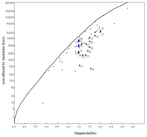
Fig. 8. Areas affected by landslides triggered by earthquakes with magnitude ≥7.0 in southwest China as a function of magnitude. Upper bound line and dots are from Keefer (1984). The triangles and numbers refer to the
identification of individual events in Table 1.
From Fig. 7 and Fig. 8, it can be seen that with the same earthquake magnitude, the areas affected by the landslides vary enormously. For example, earthquakes of No.6, 13, 14, 24, 7, 19, 22 and 26 are all with magnitude 7.0, however the areas affected by landslides change greatly from 2600 to 8843km2 when the same measurement is used.
However, the size and shape of the landslide-affected area are very similar in some areas where there are frequent occurrence of strong earthquakes, such as in Xianshuihe fault zone and Shiping-Jianshui fault zone (Fig6 & 7).
4 Conclusions
Although there are more than hundreds of earthquakes generated or supposed to generate landslides in southwest China in history, the data which can be used for deep analysis is extraordinarily few. This paper provides several earthquake examples which have comparatively detailed records of landslides distribution, and also presents a set of data regarding to earthquakes with magnitudes 7.0 or greater in this region. Despite the fact that the data set is not comprehensive, the work in this paper still allows some useful preliminary research that may be helpful in the further work.
Primary analysis shows that steep slope degree and high seismic intensity are the common characteristic of the landslides triggered by strong earthquakes in southwest China. Generally, the spacial distribution of landslides triggered by earthquake is controlled by the tectonics, such as Wenchuan earthquake and Luhuo earthquake, which occurred at Longmenshan fault zone and Xianshuihe fault zone, respectively. Landslides spread along the seismic faults and decreased quickly in the direction perpendicular to seismic faults (Huang and Li, 2008; Wang
Fig. 8. Areas affected by landslides triggered by earthquakes with
magnitude≥7.0 in southwest China as a function of magnitude. Up-per bound line and dots are from Keefer (1984). The triangles and numbers refer to the identification of individual events in Table 1.
China Earthquake Administration Bureau, 1999; Institute of Geography of Sichuan province, 1973, 1974, 1976). Finally, only 24 earthquakes with magnitude 7.0 or greater are used to calculate the landslide affected areas in this study.
Figure 7 shows the earthquake epicentres and areas of as-sociated landslides in southwest China. Figure 8 shows the correlations between the earthquake magnitude and the areas affected by the landslides, and the upper bound used here is identified by Keefer (1984).
From these 2 figures, the first observation that can be made is that all of the data dots representing landslides fall un-der the upper-bound line identified by Keefer. This means that the relationship between seismic magnitude and land-slides affected area in southwest China is consistent with the knowledge obtained by Keefer in 1984. In this study, though there are 2 approaches used to calculate the size of affected area, and different measurements would result in a different estimated size of landslides area, the affected areas can be compared when the same measurement is used.
From Figs. 7 and 8, it can be seen that with the same earth-quake magnitude, the areas affected by the landslides vary enormously. For example, earthquakes of No. 6, 13, 14, 24, 7, 19, 22 and 26 are all with magnitude 7.0, however the areas affected by landslides change greatly from 2600 to 8843 km2 when the same measurement is used.
However, the size and shape of the landslide-affected area are very similar in some areas where there are frequent oc-currences of strong earthquakes, such as in Xianshuihe fault zone and Shiping-Jianshui fault zone (Figs. 6 and 7).
4 Conclusions
Although there are hundreds of earthquakes generated with supposed generated landslides in southwest China in history, the data which can be used for deep analysis is extraordinar-ily limited. This paper provides several earthquake exam-ples which have comparatively detailed records of landslide distribution, and also presents a set of data regarding earth-quakes with magnitudes 7.0 or greater in this region. Despite the fact that the dataset is not comprehensive, the work in this paper still allows some useful preliminary research that may be helpful in further work.
Primary analysis shows that steep slope degree and high seismic intensity are the common characteristic of the land-slides triggered by strong earthquakes in southwest China. Generally, the spacial distribution of landslides triggered by earthquake is controlled by the tectonics, such as Wenchuan earthquake and Luhuo earthquake, which occurred at Long-menshan fault zone and Xianshuihe fault zone, respec-tively. Landslides spread along the seismic faults and de-creased quickly in the direction perpendicular to seismic faults (Huang and Li, 2008; Wang et al., 2008). A com-parison of the data with previous observations made during the 1973 Luhuo, 1974 Zhaotong and 1976 Longling earth-quakes show significant similarities in the distributions of the landslides with earthquake intensity and steep slope. It can be concluded that strong earthquakes, steep topography and fragile geological environment are main reasons responsible for serious landslides in southwest china.
The most important conclusion drawn from the data and the correlations explored within this study is that there are significant differences in the nature of earthquake-triggered landslides in this region. In the whole study region, even though some earthquakes had the same seismic magnitudes, there is a great difference between the areas affected by land-slides. While at the same tectonic place or fault belt, area af-fected by landslides presented similar outline and size. The difference of the characteristics of landslide distribution re-veals the influence of local geological and topographic con-ditions on landslides occurrence.
In spite of the strong correlation between earthquake mag-nitude and the area affected by landslides, the apparent con-clusion that earthquake magnitude is good criteria for pre-dicting seismically induced landslides is not very satisfac-tory even with the simplest method for predict earthquake-triggered landslides. When applying earthquake magnitude for assessing earthquake-triggered landslides hazard at 1 grade (ISSMGE, 1999), it is important to consider the lo-cal geologilo-cal condition and history earthquake background, rather than to simply rely on the basis of geographical re-gions. The knowledge drawn from this study at the same tec-tonic place or fault belt – the area affected by landslides pre-senting similar outline and size – would be useful to assess earthquake-triggered landslides hazard at a regional scale.
Also, though the magnitude is important for earthquake-triggered landslides prediction in the long term, more and more researches show that the ground shaking intensity influ-ences the occurrence of landslides to a deeper degree. Geo-logical setting in a wider region will need more attention. For example, in northwest China, where the Loess Plateau is the most widely distributed region of loess on earth, earthquake-triggered landslides in northwest China show different dis-tribution characteristics compared to earthquake-triggered landslides in southwest China. Earthquake with magnitude 5.0 or greater will cause serious geotechnical disasters in the loess sites (Wang, 2003). Deep research about earthquake-triggered landslides in Loess Plateau in China will be con-ducted in the near future.
Acknowledgements. This research was supported by Ministry of Industry and Information Technology of People’s Republic of China (Grant No. 2010ZX03006-007) and the Institute of Geology, China Earthquake Administration (Grant No. IGCEA1006). The authors would like to express deep thanks to the faculty, staff and drivers for their support in the work. Lots of thanks to the anonymous reviewers for their insightful reviews that greatly improved the manuscript.
Edited by: M. E. Contadakis
Reviewed by: two anonymous referees
References
Australian geomechanics society landslide zoning working group: Guideline for landslide susceptibility, hazard and risk zoning for land use planning, Australian Geomechanics, 42, March, 2007. Bommer, J. J., Carlos, E., and Rodr´ıguez, C. R.:
Earthquake-induced landslides in Central America, Eng. Geol., 63, 189–220, 2002.
Cornell, C. A.: Engineering Seismic Risk Analysis, Bull. Seism. Soc. Am., 58, 1583–1606, 1968.
Chen, X. L., Nobuaki, K., Ryosuke, T., and Kato, N.: Prediction of slope failure due to earthquake, Chinese Science Bulletin, 54, 2888–2894, 2009.
Chen, X. L., Zhou, B. G., Ran, H. L., Yamamoto, Y., and Hyodo, M.: Geohazards induced by the Wenchuan Earthquake, Geologi-cally Active, Taylor & Francis Group, London, ISBN 978-0-415-60034-7, 2010.
Chengdu earthquake investigation team of State seismological Bu-reau: Reports on investigation of Luhuo earthquake occurred on Feb. 6, 1973 (in Chinese).
Chinese seismic ground motion zoning working group: Seismic zonig map in China, Beijing, Standards Press of China, 2001 (in Chinese).
Earthquake Administration of Sichuan Province: 1976 Songpan earthquake (in Chinese), Beijing, Seismological Press, 1979 (in Chinese).
Earthquake Administration of Sichuan Province: 1981 Daofu earth-quake (in Chinese), Beijing, Seismological Press, 1986 (in Chi-nese).
362 X. L. Chen et al.: Earthquake-triggered landslides in southwest China
(23rd century B. C. to 1911), Beijing, Seismological Press, 1995 (in Chinese).
Earthquake disaster prevention department of China Earthquake Administration: Catalogue of modern earthquakes in China, Bei-jing, China Science and Technology Press, 1999 (in Chinese). Earthquake Administration of Yunnan Province: 1996 Lijiang
earthquake (in Chinese), Beijing, Seismological Press, 1998 (in Chinese).
Guzzetti, F., Carrara, A., Cardinali, M., and Reichenbach, P.: Land-slide hazard evaluation: a review of current techniques and their application in a multi-scale study, Central Italy, Geomorphology, 31, 181–216, 1999.
Heckerman, D.: Probabilistic interpretation of MYCIN’s certainty factors, Uncertainty in Artificial Intelligence, edited by: Kanal, L. N. and Lemmer, J. F., Elsevier, New York, 298–311, 1986. Huang, R. Q. and Li, W. L.: A study on the development and
distri-bution rules of geohazards triggered by “5.12” Wenchuan Earth-quake, Chinese J. Rock Mech. Eng., 27, 2585–2592, 2008 (in Chinese).
Institute of Geography of Sichuan province: Report of investigation on Luhuo earthquake triggered landslides on Feb. 6, 1973 (in Chinese).
Institute of Geography of Sichuan province: Report of investigation on Daguan-Yongshan earthquake triggered rock fall, landslides, debris flow on Feb. 6, 8, 1974 (in Chinese).
Institute of Geography of Sichuan province: Report of investigation on Longling earthquake triggered landslides on May 29, 1976 (in Chinese).
Institute of Geology, State Seismological Bureau: The photo album of eight strong earthquake disasters in China, Beijing, Seismo-logical Press, 1983.
ISSMGE: Manual for Zonation on Seismic Geotechnical Hazards (revised version), Technical Committee for Earthquake Geotech-nical Engineering, TC4, International Society for Soil Mechanics and Geotechnical Engineering, The Japanese Geotechnical Soci-ety, Tokyo, 1999.
Jibson, R. W., Harp, E. L., and Michael, J. A.: A method for produc-ing digital probabilistic seismic landslide, Eng. Geol., 58, 271– 289, 2000.
Keefer, D. K.: Landslides caused by earthquakes, Geol. Soc. Am. Bull., 95, 406–421, 1984.
Li, P. (Ed.): Southwest China Intensity Zoning team, State Seis-mological Bureau, Seismic intensity zonation for the marginal region of the Qinghai-Tibet plateau: a case study of the Xichang prefecture, Beijing, China Academic Publishers, 1985.
Li, X. J., Zhou, Z. H., Huang, M., Wen, R. Z., Yu, H. Y., Lu, D. W., Zhou, Y. N., and Cui, J. W.: Preliminary Analysis of Strong-Motion Recordings from the Magnitude 8.0 Wenchuan, China, Earthquake of 12 May 2008[J], Seismol. Res. Lett., 79, 844–854, 2008.
Ma, X. Y. (Ed.): Lithospheric dynamics atlas of China, Beijing, China Cartographic Publishing House, 1989.
National Institute for Land and Infrastructure Management: Min-istry of Land, Infrastructure, Transport and Tourism. A study on methodology for assessing the potential of slope failures during earthquakes, Japan, 2004 (in Japanese).
National Wenchuan Earthquake experts committee: Atlas of seis-mic hazard during Wenchuan Earthquake, Beijing, SinoMaps Press, 2008 (in Chinese).
Qi, S. W., Xu, Q., Lan, H. X., Zhang, B., and Liu, J. Y: Spatial distri-bution analysis of landslides triggered by 2008.5.12, Wenchuan Earthquake, China, Eng. Geol., 116, 95–108, 2010.
Qiao, J. P. and Pu, X. H.: A preliminary study on the distributive regulation of seismic landslide in Sichuan and Yunnan, J. Seis-mol. Res., 15, 411–417, 1992 (in Chinese).
Rodr´ıguez, C. E., Bommerb, J. J., and Chandlerb, R. J.: Earthquake-induced landslides: 1980–1997, Soil Dynam. Earthq. Eng., 18, 325–346, 1999.
Saaty, L. and Wong, M. M.: Projective average family size in rural India by the analytic hierarchy process, J. Math. Soc., 9, 181-209, 1983.
Sassa, K., Fukuoka, H., and Wang, F. W.: Dynamic properties of earthquake-induced large-scale rapid landslides within past land-slide masses, Landland-slides, 2, 125–134, 2005.
Scott, S. B. and Keefer, D. K.: Seismic landslide hazard for the city of Berkeley, California, USGS, Open file, 2001.
Shan, X. J.: Integration and application of remote sensing and ge-ographical information system technology for the evaluation of geological environment, Beijng, Institute of Geology, CEA, 1999 (in Chinese).
Southwest China Intensity Zoning Team: State Seismological Bu-reau, Investigation of seismology and geology of strong earth-quake zone in Sichuan-Yunnan region, Beijing, Seismological Press, 1979 (in Chinese).
Wang, H. B., Sassa, K., and Xu, W. Y.: Analysis of a spatial distri-bution of landslides triggered by the 2004 Chuetsu earthquakes of Niigata Prefecture, Japan, Nat. Hazards., 41, 43–60, 2007. Wang, L. M. (Ed.): Loess dynamics, Beijing, Seismological Press,
2003 (in Chinese).
Wang, Y. Q., Xin, H. B., Gao, Y. P., and Zhou, G. S.: Study on comprehensive index method for predicating earthquake-induced landslides, Chinese J. Geotech. Eng., 23, 311–314, 2001 (in Chi-nese).
Wang, Y. S., Luo, Y. H., Ji, F., Huo, J. J.,Wu, J. F., and Xu, H. B.: Analysis of the controlling factors on geo-hazards in mountain-ous epicentre zones of the Wenchuan Earthquake. J. Eng. Geol., 16, 759–763, 2008 (in Chinese).
Wen, B. P., Wang, S. J., Wang, E. Z., and Zhang, J. M.: Character-istics of rapid giant landslides in China, Landslides, 4, 247–261, 2004.
Wilson, R. C. and Keefer, D. K.: Predicting areal limits of earthquake-induced landsliding. In evaluating earthquake haz-ards in Los Angeles region, US Geological Survey, Professional Paper 1360, 317–345, 1985.
Xu, X. W., Zhang, P. Z., and Wen X. Z.: Features of active tectonics and recurrence behaviors of strong eaathquakes in the western Sichuan province and its adjacent regions, Seismol. Geol., 27, 446–461, 2005 (in Chinese).
Yang, T., Deng, R. G., and Liu, X. L.: The distributing and subarea character of the seismic landslides in Sichuan, J. Mountain Sci., 20, 456–460, 2002 (in Chinese).
Yi, G. X., Wen, X. Z., and Xu, X. W.: Study on recurrence behaviors of strong earthquakes for several entireties of active fault zones in Sichuan-Yunnan region, Earthquake research in China, 18, 267– 276, 2002 (in Chinese).
Yin, Y. P., Wang, F. W., and Sun, P.: Landslide hazards triggered by the 2008 Wenchuan earthquake, Sichuan, China, Landslides, 6, 139–152, 2009.
Zhang, L. M.: Challenges in multi-hazard risk assessment and man-agement, Geohazard chain in Beichuan Town caused by Great Wenchuan Earthquake, in: Geotechnical Risk and Safety, Taylor and Francis Group, London, 237–244, 2009.
Zhang, P. Z., Deng, Q. D., Zhang, G. M., Ma, J., Gan, W. J., Min, W., Mao, F. Y., and Wang, Q.: Active tectonic blocks and strong earthquakes in the continental of China, Science in China (Ser D), 46 (Suppl), 13–24, 2003.