Developing A Mobile GIS Tour Guide App For
Dar-Es-Salaam City, Tanzania.
Rigobert Francis Buberwa, Anastazia Msusa
Abstract: Navigation around Dar-es-salaam City for foreigners is often not easy, transit using Google Maps, Open Street Maps or Bing Maps is usually difficulty as they lack detailed information. Integration of Geographic Information System (GIS) and Information Communication Technology (ICT) has improved tools used to query spatial related databases, this study strives to develop a Mobile GIS app for tour guide in Dar-es-salaam; the study uses a customized Unified Network for Transport (UNETRANS) in developing the App. To meet this objective, the Mobile App was developed using C# programming language and Xamarin tools in Visual Studio Integrated Development Environment, and implemented in a three- tier architecture which runs on Windows and Android Operating Systems. The study has successfully developed an App which responds to number of GIS network analysis queries, including route selection and nearest landmark. Being the pilot study, the study was limited to Main roads in Dar-es-salaam only.
.
Index Terms: Location Based Services, Mobile Application, Unified Modeling Language, GIS-T data model, Three-tier Client Server Architecture, Integrated Development Environment, Graphical User Interface.
————————————————————
1
I
NTRODUCTIONGeographic Information System (GIS) is an information specializing in the input, storage, manipulation, analysis, reporting, and visualization of spatially referenced data[1]. GIS provides platform for planning, making policies, and management in various fields including but not limited to construction, environment, agriculture, and transportation. Most transport information problems are spatially referenced; this has triggered for the foundation of a new branch of GIS which deals with transportation issues known as Geographic Information System for Transportation (GIS-T), there exists a number of departments in transportation sector where GIS-T can be applied, these include infrastructure planning, design and management, transportation safety analysis, travel demand analysis, traffic monitoring and control, public transit planning and operations, environmental impact assessment, hazards mitigation, and Intelligent Transport System (ITS). GIS-T is a link between Transport Network database and Geo-database, the manipulation between the two provides better planning and decision making tool by enabling an efficient means of displaying transport network. GIS-T can be therefore defined as the principles and applications of Geographic Information Technologies to transportation problems[2]. The rapid development of Information Communication and Technology (ICT) on the other hand, has triggered revolution of Mobile GIS. mobile GIS has enabled mobile users to move in a geographic space, know their spatial location and have an access to wide geographic information. It is important to exploit this evolution for spatial decision support and movement management, Mobile GIS is essentially made to reduce the time and energy spent in navigation[3]. There are various technologies utilized by Mobile GIS applications based on software packages and hardware devices, these technologies have lead to Mobile GIS application being referred to as Location -Based Services (LBS)[4]. This study strives to analyze, design and develop a Mobile Geographic Information System App to be used as a tour guide in Dar-es-salaam, Tanzania.
2
LIRETATURE
REVIEW
2.1 Mobile GIS and Location Based Services
Mobile GIS enables users to know their location on a small screen, and may be connected to the internet or other devices in offline mode[3], drawing on Tsou [5], Mobile GIS can be
defined as an integrated software/hardware framework for the access of geospatial data and services through mobile devices via wired or wireless networks. Mobile GIS can be applied in two major areas : Location Based Service (LBS) and Field based GIS, while the later deals with GIS data collection, data validation and update in the field such as changing the attribute table or adding new points on the existing GIS dataset, the former (concern of this study) focuses on business-oriented location management function such as navigation, street routing, finding a specific location, or tracking vehicle[6]. Location Based Service may be defined as information services accessible with mobile devices through the mobile network and utilizing the ability to make use of the location of the mobile device[7], similarly Open Geospatial Consortium (OGC) defines Location Based Services as a wireless-IP service that uses geographic information to serve a mobile user[8]. The two definitions seem to describe three technologies namely: The new Information and Communication Technologies (NICTs) such as hand held devices and mobile telecommunication; Geographic Information Systems; and, Internet [9]. LBS enable the user to request information needed, his preference and position. The provider of such location service delivers information as per user‘s needs. The idea behind LBS is to answer three basic questions; where am I? Where are my friends? What is here around me?[10]. To answer the above posed questions, LBS requires a mobile device, positioning capabilities, a communication network, and a service and content provider.
2.2 GIS-T Data Model and UNETRANS
an evolution of ARCGIS, Butler [13] proposed an improved UNETRANS data model by aggregating six packages in four packages see Table 1 .
Table. 1. Aggregated Package definition of the improved UNETRANS [13]
Package Name Package Description
Inventory
The package includes support for all types of transportation facilities, including their characteristics and elements
Network
The package takes care of the transportation-specific network data model used by ARCGIS Network Analyst extension, which replaces the geometric network model used by the original UNETRANS
Events
The package combines the former activities and incidents packages into comprehensive group of entities that represent thing that happens and transport facilities
Mobile Objects
The package involves users of the transportation system and it expands the original Mobile Object Package
Customizing an improved UNETRANS for the purpose of this study, only the Network package was found relevant. Figure 1 and Table 2, present a customized conceptual model for developing Mobile GIS tour guide App for Dar-es-salaam city and its definition respectively.
Fig.1. Conceptual model of the Network package city modified after [14]
Table .2. Object and Feature class definitions for the conceptual model of the Network Package modified after [14]
Object/Feature Class Object/Feature class definition
SimpleJunctionFeatureClass A representing simple simple feature spatial class feature of transport network.
ObjectClass
A list of tables representing non-spatial data related to any transport network.
FeatureClass
A spatial feature representing points, lines, or polygon on transport network.
TransportJunction
A feature that bounds a Route Link or any significant point of interaction between transport routes.
BusRoute
An object that associates RouteFeature, BusStop or BusTerminal into a comprehensive set of travel information.
RoadFeature
Any linear object intended to represent a right-of-way for transportation activities
BusStop
A point where passengers can board or alight a public transport.
BusTerminal
One or more stops point close to each other. It is also a type of TransportJunction representing a hub location for bus travel where passengers can board busses, transfer between busses, and get travel information.
BusInformation
Records of all buses registered for transport business as city buses.
BusRouteInformation A link Class between BusRoute and BusInformation classes
3
METHODOLOGY
The study was informed by both qualitative and quantitative data obtained from Tanzania Surface and Marine Transport Regulatory Authority (SUMATRA). The data used include: digitized Terminals (bus, taxi, train and ferry), digitized bus stops, and landmarks, Satellite images from Bing Map Provider servers, digitized bus routes, and photographs.
3.1 Systems Activities and Analysis
System
Mobile App user
Mobile App Administrator Launch Mobile App
Request Route information
Navigate to find destination
Update Geo-database
Print Report <<extend>>
Figure. 2. Use case diagram of the Mobile GIS app for Tour Guide in Dar-es-salaam
3.2 Mobile GIS Tour guide App Design and Development
The development of a Mobile GIS tour guide app for Dar-es-salaam city was done using Three-Tier Client –Server Architecture, this was due to the fact that the memory size of Bing Maps used in the application were huge as compared to that of most Mobile devices, so an external database to store these maps was necessary. Logically the architecture partitions major functions into three tiers:
3.2.1The Presentation tier
This tie was coded using C# programming Language and Xamarin tools, it runs on Android and Windows platform so as to enable users of the App communicate with the application tier for instance in finding locations and getting alternate routes to a destination. The Interface was made easy to interact with, using either English or Swahili language (Local Language).
3.2.2Application tier
This is the tier in which the user‘s requests are processed and it serves as a connection between the presentation tier and the data tier. It requires the presence a web application server, which listens to connection requests from mobile GUI (Client-side) and direct the requests to relevant application module for service[15]. In this study application tier used data from inbuilt local database stored within the App‘s root directory.
3.2.3Data tier
This component hosts the database of the model; it serves as a warehouse of data [16]. Data tier stores and manages spatial and non spatial data of road network and features of interest. The data tier was divided into two categories namely; the Bing Map Provider servers whereby the application tier fetches the background satellite images of BING Map providing Dar-es-salaam city roads network, and the Mobile GIS-T Geodatabase developed from Figure 3.
3.3 Geodatabase development for Mobile GIS Tour App UML mapping rules were used to map classes in Figure 1 into Relational tables and ultimately into flat files and kept in text file, each text file housed a table containing spatial and non spatial data of bus stops, route, other landmarks such as
religious centre, health centers, hotels and restaurants, government offices, and filling stations arranged in an order showing PointName, its latitude, longitude and its description
Figure. 3. Geodatabase design
4
DISCUSSION
OF
THE
RESULTS
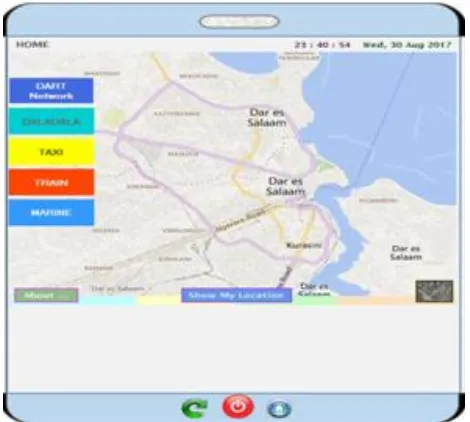
The Mobile GIS Tour guide App interface was developed to display five major layers and twelve minor layers namely: Dalala (The commuter buses), Taxi, Marine, Train (Figure 4) and twelve minor layers which are: Banks, Churches, Mosques, Filling stations, ATMs, Education Centers, Food/Restaurants, Government offices, Hospitals, Hotels, and Shopping Centers. User of an App need to select any layer or combination of layers he/she wishes to navigate. The developed App includes also GIS network analysis modules such as:
4.1 Route Selection
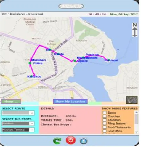
This module enables the App user to navigate from one point to another using several alternative routes in Dar-es-salaam. The App user needs to select type of transportation (Daladala, Taxi, Marine or Train). In case of Daladala, one needs to click the ‗SELECT ROUTE ‗option and then SELECT BUS STOP which shows all intermediate bus stops between the origin and destination bus stops see Figure 5 and Figure 6
Figure .5. Mobile GIS App showing Bus route from Kariakoo to Kivukoni.
Figure .6. Mobile GIS App showing Bus route from Kariakoo to Kivukoni indicating intermediate Bus stops.
4.2 Finding the nearest Land Mark
This study has also covered some Location-Based services such as ―what is nearest‖, ―how can I go to‖ and ―find the nearest‖. The app in Figure 7 through to Figure 10 shows the nearest Bus stops, Health Centers, Filling Stations and Shopping Centers respectively.
Figure .7. Mobile GIS App showing the nearest Bus Stops from the App user
Figure.9. Mobile GIS App showing the nearest Filling stations from the App user
Figure .10. Mobile GIS App showing the nearer shopping Centers from the App user.
5
CONCLUSION
This study has successfully developed a Mobile GIS App by customizing an improved UNETRANS data model., the App might be used as a tour guide map to people new to Dar-es-salaam City. The output of this study has been found instrumental in responding to number of spatial related GIS network queries, such as route selection and navigation, finding the nearest landmark, and determining the App user location. Being the pilot study, it was limited to Dar-es-salaam main roads only. The study is now been extended to cover other types of road in Dar-es-salaam and later to other cities within Tanzania.
6
REFERENCES
[1]. Mapa, S. and R. Lima, Combining Geographic Information Systems for Transport and Mixed Linear Programming in Facility Location-Allocation Problems. Journal of Software Engineering and Applications, 2014. 7(10): p. 844-858.
[2]. Shaw, S. and J. Rodriques, Geographic Information System for Transportation (GIS-T), in The Geography of Transport Systems. 2006: New York Routledge.
[3]. Eleiche, Network Analysis Methods for Mobile GIS. 2011, University of West Hungary.
[4]. Peng, Z., R and M. Tsou, H, Internet GIS: Distributed Geographic Information services for the internet and wireless networks. 2003, New York: John Willy nd Sons, Inc.
[5]. Tsou, M., H, Integrated Mobile GIS and Wireless Internet Map Servers for Environmental Monitoring and Management. Journal of Cartography and Geographic Information Science, 2004. 31(3): p. 153-165.
[6]. Jagoe, A., Mobile Location Service: the definitive guide. 2002, Upper Saddle River, New Jersey: Prentice Hall.
[7]. Virrantaus, K., et al. Developing GIS-Supported Location Based Services. in Proc.of WGIS'2001-First International Workshop on Web Geographical Information Systems. 2001. Kyoto, Japan.
[8]. OGC, Open Location Services. Open Geospatial Consortium, 2005. 1(1).
[9]. Shiode, N., et al., eds. The impact and Penetration of Location Based Services. Telegeoinformatics, ed. H. Karimi and A. Hamadi. 2004, CRC Press. 349-366.
[10]. Steiniger , S., M. Neun, and A. Edwardes. Foundations of Location Based Services. 2006 [cited 2018 8 November]; Available from: https://www.researchgate.net/publication/230777155_ Foundations_of_Location_Based_Services.
[12]. Kayondo , M., L, G. Bax, and S. T-Togboa, S. Geographic Information Systems for Transportation-Data Model for Road Infrastructure Maintenance in Uganda. in Advances in Geomatics and Research. 2011. Kampala -Uganda.
[13]. Butler, J., A, Designing Geodatabases for Transportation. 2008: ESRI Press.
[14]. Ngereja, Z., R, Towards a GIS-T Database Design Design and Implementation for Public Transit Planning- The Case Study of Dar-es-Salaam Metropolitan City, Tanzania. 2009, New University of Lisbon.
[15]. Whitten, J., L and D. Lonnie, C, Introduction to Systems Analysis and Design. 2008: McGraw Hill.
![Fig.1. Conceptual model of the Network package city modified after [14]](https://thumb-us.123doks.com/thumbv2/123dok_us/8632329.1422037/2.612.41.297.403.666/fig-conceptual-model-network-package-city-modified.webp)