Design and Implementation of Mobile Map
Application for Finding Shortest Direction
between Two Pair Locations Using Shortest Path
Algorithm: A Case Study
1Akinwol Agnes Kikelomo., 2Yekini Nureni Asafe., 3Adelokun Paul., 4Lawal Olawale N
1,3,4
Department of Computer Technology, Yaba College of Technology, Yaba.
2
Department of Computer Engineering, Yaba College of Technology, Yaba.
---ABSTRACT--- The shortest path problem is an approach towards finding the shortest and quickest path or route from a starting point to a final destination, four major algorithms are peculiar to solving the shortest path problem. The algorithms include Dijkstra’s Algorithm, Floyd-Warshall Algorithm, Bellman-Ford Algorithm and Alternative Path Algorithm. This research work is focused on the design of mobile map application for finding the shortest route from one location to another within Yaba College of Technology and its environ. The design was focused on Dijkstra’s algorithm that source node as a first permanent node, and assign it 0 cost and check all neighbor nodes from the previous permanent node and calculate the cumulative cost of each neighbor nodes and make them temporary, then chooses the node with the smallest cumulative cost, and make it as a permanent node. The different nodes that lead to a particular destination were identified, the distance and time from a source to a destination is calculated using the Google map. The application then recommends the shortest and quickest route to the destination.
Keywords: Map, Mobile map, Dijkstra’s Algorithm, Floyd-Warshall Algorithm, Bellman-Ford Algorithm, Alternative Path Algorithm, Shortest path problem
--- --- Date of Submission: July 19, 2017 Date of Acceptance: July 26, 2017 --- --
1.
INTRODUCTION
A
map is a visual representation of an entire area or a part of an area, typically represented on a flat surface. The work of a map is to illustrate specific and detailed features of a particular area, most frequently used to illustrate geography. There are many kinds of maps; static, two-dimensional, three-dimensional, dynamic and even interactive. Maps attempt to represent various things, like political boundaries, physical features, roads, topography, population, climates, natural resources and economic activities [1].A map is useful for both a layman and an intelligent person, as maps contain loads of information. It is up to an individual how he makes use of it. Maps are generally used for: Analysis; Confirmation, Communication, Decoration, Collection, Investment, Exploration, Hypothesis Stimulation Navigation, Control & Planning, Map Reading, Storage of Information, Historical perspective [2].Some maps are created with very specific goals in mind. The focus of this research work is to create a map for to determine shortest path between two locations on a map. The study is to use the graph theory to develop mobile map for Yaba College of Technology campus using shortest path algorithm to determine the shortest and fastest route from source to destination. In Yaba College of Technology, there is no provision of map used for locating buildings within the school campus. The school only provide the map to specify route that leads to various
buildings in the college. The process is manual which is time consuming and sometime lead to frustration for first time visitors and others. Different route can lead to a particular location within the college. This route has different distance that they cover and can be difficult to choose the exact route if one is not familiar with the school environment. The research work is to achieve the following objectives: to discover the shortest route from a particular source to a destination, and to design a model for shortest path and implement the model designed.
2.
LITERATURE REVIEW
2.1.Graph and its Application
Graph is a diagram (as a series of one or more points, lines, lines segments, curves, or areas) that represents the variation of a variable in comparison with that of one or more other variables. It is also the collection of all points whose coordinates satisfy a given relation (as a function). Graph is a collection of vertices and edges that pairs of vertices [3].
2.2.Types of Graph
each edge has a direction;Simple Graph: A graph with no loops and no parallel edges; Connected Graph: A graph G is said to be connected if there exists a path between every pair of vertices; Disconnected Graph: A graph G is disconnected, if it does not contain at least two connected vertices;Regular Graph: A graph G is said to be regular, if all its vertices have the same degree. In a graph, if the degree of each vertex is ‘k’;Complete Graph: if a vertex is connected to all other vertices in a graph;Cycle Graph: If the degree of each vertex in the graph is two;Cyclic Graph: A graph with at least one cycle;Acyclic Graph: A graph with no cycles;Bipartite Graph: A simple graph G = (V, E) with vertex partition V = {V1, V2} is called a bipartite graph if every edge of E joins a vertex in V1 to a vertex in V2;Complete Bipartite Graph: A bipartite graph ‘G’, G = (V, E) with partition V = {V1, V2} is said to be a complete bipartite graph if every vertex in V1 is connected to every vertex of V2; and Star Graph: A complete bipartite graph of the form K1, 1 is a star graph with n-vertices. A star graph is a complete bipartite graph if a single vertex belongs to one set and all the remaining vertices belong to the other set. Graph of any of the categories mentioned can be used to solve Shortest Path Problems; Network Flow Problems; Matching Problems; 2-SAT Problem; Graph Coloring Problem; Traveling Salesman Problem (TSP)[4,5].
2.3.Shortest Path Problem
Shortest path is a fundamental problem in graph theory. It is can also be one of the principal problem in network analysis. The shortest path problem is a problem of finding the shortest path or route from a starting point to a final destination. Generally, in order to represent the shortest path problem, we use graphs. A graph is a mathematical abstract object, which contains sets of vertices and edges. Edges connect pairs of vertices. Along the edges of a graph it is possible to walk by moving from one vertex to other vertices. Depending on whether or not one can walk along the edges by both sides or by only one side determines if the graph is a directed graph or an undirected
graph. In addition, lengths of edges are often called weights, and the weights are normally used for calculating the shortest path from one point to another point. In the real world it is possible to apply the graph theory to different types of scenarios.
For example, in order to represent a map, we can use a graph, where vertices represent cities and edges represent routes that connect the cities. If routes are one-way then the graph will be directed; otherwise, it will be undirected. Another definition of Liu, "The path(s) through the network from a known starting point to an optional ending point that minimizes distance, or some other measure based on distance, such as travel time". Furthermore, there are three main types of shortest path problems. Which are: Single source shortest path (SSSP) algorithms; Single destination shortest path (SDSP) algorithms; All-pairs shortest path (APSP) algorithms [6,7].There exist different types of algorithms that solve the shortest path problem that uses geneticalgorithm which include: Dijkstra’s Algorithm; Floyd-Warshall Algorithm; Bellman-Ford Algorithm; and Alternative path algorithm [8,9,10].
3.
RESEARCH METHOD AND DESIGN
3.1.Research Data
In the process of design of proposed application, we source for data about various popular locations within YabaTech. The locations are:
First gate Second gate Medical center Library New building art complex college hall food village science complex
Since the research is focus on design of a software, we develop a program algorithm that will serve as guide for coding with the use of appropriate programming tool.
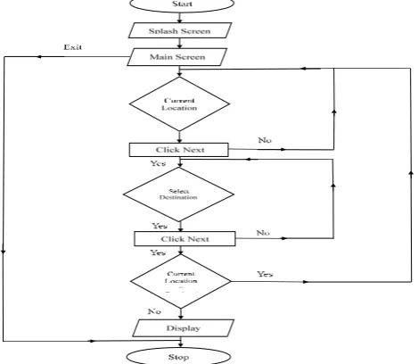
The following procedure explains how the system flowchart works
i. User launches the application’s icon
ii. The welcome screen displays and then takes the user to the main screen
iii. User is asked to select his / her current location iv. User is asked to select his / her destination.
v. Click Next
vi. It tests if the current location is not equal to destination. If current location is equal to destination, then it will go back to select current location. Else
vii. It will display result and stop. 3.2. Programming Tools
The programming tools proposed to be use for design of the proposed system is:
Android studio: This is software used in coding and designing native android applications. It contains XML files and Java files. The reason for the choice of programming language is because the Android Operating System is one of the major Operating Systems dominating the world of mobile devices nowadays and since mobile devices are also trending, beating down the usual use of laptops and desktops, the decision of designing a mobile application was birthed.
Android SDK: This is software that is used for developing android application.
3.3.System Design and Specification
This application will be design to show different locations in the college. It shows the distances between a pair of location selected and also displays them on a map and advices user on the shortest routes from the origin to the destination of the journey within the college.
The input specification describes the kind of information that will be feed into the application to be designed while the output specification lay emphasis on how the appearance and the kind of result the application will produce after it has been successfully executed, aftermath of debugging.
The following are the Input Specification requirement:
The user is required to select his/her current location.
The user is required to select his/her Destination. The following are the output specification requirement:
The application displays the distance to cover and also shows the route to the destination in meters.
The application also shows you the time required to get to your destination from your source.
Table 1: Data Structure for Source and Destination database design
Field Name Data
type
Length
Source Char 1 - 255
Destination Char 1 - 255
4.
IMPLEMENTATION AND TESTING
The algorithm in figure I was coded using the proposed programming language, and data structure in table I. The system was implemented, debug and tested, and it was observed that the research objective was achieved and the program has since been deployed for usage free of charge within and outside the college. The figure 2 shows the splash screen after launching of the program.
Figure 2: Splash Screen
Figure 3: Main Activity Users Interface
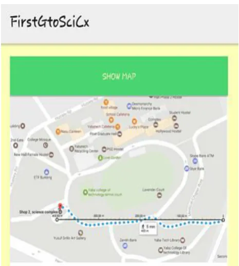
After selection of the locations, a user interface as shown in figure 4 appear and user can then pair two different location and view the path to his or her destination. In figure 4 the pair locations are first gate and science complex and the result displayed is as shown figure 5. The shortest path is shown in the map display.
Figure 4: Pair Locations for first gate and science complex
Figure 5: Result for pair location first gate and science complex.
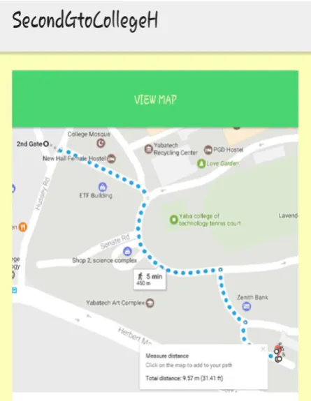
The System was also tested to find the shortest path between: first gate and college hall, and second gate to college hall. The alternative route was shown for the two pair and the result was displayed and compared to have significant time difference. figure 6,7,8, and 9 shows the displayed result.
Figure 7: Alternative route first gate to college hall
Figure 8: Shortest path second gate to college hall
Figure 9: alternative route second gate to college hall
If two same locations are selected no map will be displayed instead the following user interface with inscription you cannot pair two same locations will be display and the system will advise the user to pair two different location. see figure 10. User can then click back button to select two different locations.
Figure 10: users interface for two same locations
5.
CONCLUSION
within the locations. The distance and time of different nodes that leads to a particular destination were identified and compared in order to choose the shortest and fastest route in the network. A mobile map application was designed and implements using the Android studio, and Android SDK. The system was tested and it meets the standard and solution required to resolve the problem identified.
REFERENCES
[1.] Mojo H., (2016). Graph theory. Available at www.en.m.wikipedia.org/wiki/Graph_Theoy. Retrieved 9th August 2016.
[2.] Map of India (n.d) what is map? available at http://www.mapsofindia.com/what-is-map.html. Retrieved on December 25th, 2016.
[3.] Merriam W., (2016). Definition of Graph. Available at www.merriam-webster.com/Dictionary/graph. retrieved 13th July, 2016.
[4.] Jaehyun, P. (2015), Basic Graph Algorithms. CS 97SI. Stanford University.
[5.] Amanda B., (2016). Types of maps. Available at www.thoughtco.com/types of maps. retrieved 19th august 2016.
[6.] Al-Tameemi, H.L.H., (2014). Using Dijkstra Algorithm in Calculating AlternativeShortest Paths for Public Transportation with Transfersand Walking. Ankara.
[7.] Kairanbay, M., &Hajar, M.J., (2013). A Review and Evaluations of Shortest Path Algorithms. International Journal of Scientific and Technology Research, Vol 2, 99-101.
[8.] Holger, B., Stefan, F., Peter, S., Dominik, S., &Domagoj, M., (2010). Transit Ultrafast Shortest-Path Queries with Linear-time Preprocessing. Germany.
[9.] Avdhesh, K.S., & Sourabh, K., (2013). Finding of Shortest Path from Source to Destination by traversing every Node in wired Network International Journal of Engineering and Technology, Vol 5, 2655-2656.