NETWORK ANALYSIS USING GIS AND REMOTE SENSING FOR
EMERGENCY RESPONSE SYSTEM OF PUNE CITY
Ashwini D. Saindane1
1. INTRODUCTION
A hazard becomes a disaster only when it affects human settlements and causes loss of life and damage to property. In order to reduce the impact of such events proper mitigation efforts have to be generated through an emergency response system. It means an immediate response to any risk hazard condition generated and efforts to mitigate the disaster at the earliest. These may be related from health of human beings too saving life, property, and surrounding environment. Emergency situations require a quick and focused response as human life and property are at stake.
High concentrations of humans in cities and their activities make them vulnerable to various kinds of risks arising from a variety of activities leading to an emergency condition. A larger proportion of population in any metropolitan cities lives in poor quality houses, which are often overpopulated, hence are more prone to fire. Therefore, it is more or less essential in congested cities to have a proper and adequate fire protection system. Due to the rapid increase in population, industrialization, rapid rise in new colonies, construction of high-rise building etc, and the fire risk in the cities has been tremendously increased.
A proper emergency response management system is required which encompasses two to three services in the cities to protect its population and property from risks e.g. fire station, ambulance and hospital services. Each emergency situation caters to a different service need. Appropriate planning and management of these services is needed for appropriate urban management as a whole. Geographical Information System (GIS) can become a strong tool in handling emergency response based management system as it supports large datasets and analysis with a large number of variables and thus can substantially help in spatial decision-making.
2. SIGNIFICANCE OF STUDY
The planning and mitigation of disasters require huge amount of accurate information regarding the geographical area under consideration. The research work is different from other work. Usually, the researcher and the scholar use traditional techniques, approaches and tools designed for emergency response system are experiencing inadequate to deal with rapid change.
Therefore, this study has been selected to understand the issues with a holistic approach. The integrated use of modern technology like GIS and GPS has used to assess the emergency response system of Pune city for mitigation plan. Present research work focusing on network analysis of fire and medical services for encouraging an effective response system in order to minimize adverse impact on environmental, cultural, social and economic sector.
3. EMERGENCY MANAGEMENT:
Emergency management (or Disaster Management) is the discipline that deals with emergency and helps in avoiding risks. It involves preparing, supporting and rebuilding society when natural or human-made disasters occur. In general, emergency management is the continuous process by which all individuals, groups and communities manage hazards in an effort to avoid or ameliorate the impact of disasters resulting from hazards. Actions taken depend in part on perceptions of r isk of those exposed. Effective emergency management relies on thorough integration of emergency plans at all levels of government and non-government organizations. Activities at each level (individual, group, community) affect every other level. It is common
1
Department of Geography, S. P. College, Pune, Maharashtra, India
International Journal of Latest Trends in Engineering and Technology
Vol.(14)Issue(4), pp.018-025
DOI: http://dx.doi.org/10.21172/1.144.05
e-ISSN:2278-621X
Abstract- Network Analysis present multiple solution aspects for a variety of problems related to spatial networks include finding the most efficient travel route, generating travel directions, locating the closest facility and defining service areas based on travel time and distance covered. The present study demonstrates the potential use of network analysis in defining the best service area of different services such as hospitals and fire stations of Pune City (PMC). In addition, to identified service area using buffer analysis tool. Present study purposes used Google earth image of Pune City. Initially, digitization was carried by using Arc GIS software in point, line and polygon feature for various analysis. It also helps in analyzing the shortest distance path for Emergency Response System of Pune City.
to place the responsibility for governmental emergency management with the institutions for civil defense or within the conventional structure of the emergency services.
4. PHASE ACTIVITIES:
The nature of emergency management is highly dependent on economic and social conditions. The process of emergency management involves four phases: mitigation, preparedness, response and recovery.
4.1 Mitigation:
Mitigation is mainly about knowing and avoiding unnecessary risks. This includes assessment of possible risks to personal/family health and property. One example of mitigation would be to avoid buying property that is exposed to hazards, e.g. in a flood plain, in areas of subsidence or landslides. Homeowners may not be aware of a property being exposed to a hazard until it strikes. However, specialists can be hired to conduct risk identification and assessment surveys. Purchase of insurance covering the most prominent identified risks is a common measure.
Figure 1.1 Emergency Response System Cycle 4.2 Preparedness:
Unlike mitigation activities, which are aimed at preventing a disaster from occurring, personal preparedness focuses on preparing equipment and procedures for use when a disaster occurs, i.e. planning. Preparedness measures can take many forms which include construction of shelters, installation of warning devices, creation of back-up life-line services (e.g. power, water, sewage) and rehearsing evacuation plans.
4.3 Response:
The response phase includes the mobilization of necessary emergency services in the disaster area. This includes movement of core emergency services, such as firefighters and ambulance crews. They may be supported by a number of secondary emergency services, such as specialist rescue teams.
4.4 Recovery:
The recovery phase starts after the immediate treatment to human life affected by the catastrophic event. During reconstruction it is recommended to consider the location or construction material of the property. The most extreme home confinement scenarios include war, famine and severe epidemics and may last a year or more. Planners for these events usually buy bulk foods and appropriate storage and preparation equipment, and eat the food as part of normal life.
5. SELECTION OF STUDY AREA
6. OBJECTIVE
The main objective of the present research work is to assess emergency response system of Pune city using geospatial tools.
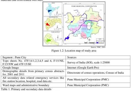
7. DATABASE
The data collection involved collection of topographical maps, ward maps, satellite data and demographic details. The environment of these data and their source are shown in Table 1. The Survey of India topographical maps scale 1:50,000 will be used for the current study of the following features: drainage, water bodies, contours, roads and rail network and administrative boundaries. Other data sources are satellite images of Pune city, various maps collected from published materials and from related web sites.
Figure 1.2: Location map of study area
Segment : Pune City Sources
Topo sheets No. 47F/14/1,2,3,4,5 and 6, F/15/NE,
F/15/NW and 47F/15/SE Survey of India (SOI), scale 1:25000
Google Image Internet (Google Earth Pro)
Demographic details from primary census abstracts
for, 2001 and 2011 Directorate of census operations, Census of India
All secondary data related emergency services like
fire station location, hospital, road data etc. Pune Municipal Corporation (PMC)
Ward maps and administrative boundary Pune Municipal Corporation (PMC)
Table 1: Primary and secondary data details
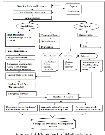
8. METHODOLOGY
The present research work is divided into several stages some of them are consecutive and the rest are concurrent (Figure 1.3). The methodology followed in this research is summarized in the following stages:
Step I - Literature review: Exhaustive literature survey of the topic of investigation is to be undertaken. Published Literature, Reports have collected from various libraries, institutes; Govt. departments etc. Besides, relevant literatures will also reference books, Bulletins, Review etc. by obtained through Internet facility.
Step II - Data collection and Preprocessing:
The data collection is considered as the most time consuming phase in initial stage of research. It takes huge human effort to collect the appropriate data which is divided in two types: spatial and non-spatial data. In the present study, topographical maps collected from Survey of India, Pune. Preprocessing has involved scanning, geo-referencing and digitization of Survey of India Topo sheets at 1:50,000 scales to serve as the base map. Firstly, Survey of India (SOI) topo sheets have geo-referenced using WGS 1984, Universal Traverse Mercator (UTM) projection system. After geo- referencing the SOI topo sheets and other maps have digitized in different features like point, line and polygon such as administrative boundaries, roads and railway network, contour, drainage network and built-up area etc.
Step III - Field visit:
Field visit is an important step to understand the ground truth and complexity of a dynamic phenomenon in emergency services of the study area. This step indicates the visit to the study area in different time or period using Global Positioning System (GPS) instrument and digital camera etc.
Step IV - Laboratory work:
Step V- Data analysis:
Firstly, road network and location of services like fire, hospital and police stations has been extracted through Google image and to assess the vulnerable areas and existing emergency response system of study area. Based on the road network markup of various facilities like fire, medical center, police station etc is done. The shortest path to reach incident place and related associate place is prepared. Fire risk zone identification based on slums, industries, mills and petrol pumps along the road network is arranged. Emergency support systems like fire brigade station and medical center facility management are located. Step VI - Report writing and submission:
Finally, data generated during the field and laboratory study has collated, analyzed, interpreted and results.
9. ANALYTICAL FRAMEWORK:
Figure 1.3:Flowchart of Methodology
10. EMERGENCY RESPONSE SYSTEM OF PUNE CITY
Emergency response means immediate action based on accurate information. For efficiency, we need proper infrastructure, modern technology, total alertness, specialist application and very important heavy investment. An emergency response is required for the city to counter the increasing risk and threats in reality as well as in perceptions. It is important to understand that just giving theoretical solution to improve efficiency is not enough as the department or organization, which is supposed to implement the proposal, needs to be looked into deeply. The GIS based emergency response management system supports mitigation of various disasters that occur in the city area of Pune city. Mainly this system provides solution or ideas for certain disaster mitigation within city area based on road network, basic utility facilities and land use/ land cover. Present research work carried out buffer analysis for identified services area of fire and hospitals. In addition, to research work demonstrates network analysis for identified shortest distances between fire incidents and small & big accidents in relation to emergency response system
11. BUFFER ANALYSIS FOR EMERGENCY SERVICES OF PUNE CITY:
The buffer analyses of fire stations, ambulances services and major hospitals have done in multiple ring buffer analysis tool in Arc GIS environment.
12. SERVICE AREA OF FIRE BRIGADE STATIONS IN PUNE CITY:
Figure 2.1: Buffer Analysis of fire stations in Pune city
13. SERVICE AREA OF MAJOR HOSPITALS IN PUNE CITY:
In Pune Municipal Corporation (PMC) runs, about 50 hospitals and municipal clinics spread over the city jurisdiction. There are also 528 private hospitals and 19 family welfare centers registered with the PMC. Here, we have assessed the service area of major hospitals with buffer areas of 1 kilometer and 2 kilometer. In present study service area is created around the hospital point for finding that how many other facilities are present within 1000m and 2000m area. So that in any case the particular hospital is closed user can immediately find out the other one within the accessible area. Hospital services like ambulance, blood bank, CT scan, MRI Scan could not able to provide immediately or quick in peripheral areas like Wagholi, Dhanori, Sus, Dhyari, Mundhwa, Manjari Budruk, Undri and Pisoli etc (Figure 2.2;2.3).
Figure 2.2: Buffer Analysis of Major Hospitals in Pune city
Figure 2.3: Buffer Analysis of Ambulance Service in Pune city
14. SHORTEST PATH ANALYSIS FOR EMERGENCY SERVICES OF PUNE CITY
range of applications in transportation (Lim and Kim 2005). Naqi et al. (2010) stated that the shortest path helps calculate the most optimal route, and optimal routing is the process of defining the best route to get from one location to another. The best route could be the shortest or fastest depending on how it is defined. Rapid emergency response to the scene of a traffic accident and transportation of the injured to a medical facility is critical for saving lives. Traffic congestion is a major problem in urban areas and Davis County, Utah is no exception. Traffic congestion can disrupt emergency response, but dynamic network routing can offer solutions. A GIS can be a useful tool for determining emergency vehicle response routing, and the application of dynamic variables like historical traffic count data can help emergency response vehicles avoid traffic congestion and improve response times.
15. CREATION OF MAP FOR HEALTHCARE AND FIRE FACILITIES:
Figure 2.4: Fire and Hospital facility Map
Data collected like coordinates of location with the help of GPS instrument. Based on these data created map of hospitals and fire station location in ArcGIS platform (Figure 2.4).
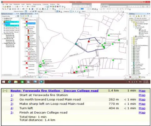
16. CREATION OF SHORTEST PATH:
With the help of network analysis tool to find out shortest path between two locations by calculating the distance based on road length. This will help the user to reduce the traveling time to reach a particular hospital. Figure 2.5 to 2.8 shows that, the shortest distance from incidence to Yerwada fire station, Accidental Place to Mamata, Amit, Kataria, Hospitals near Deccan College road, Pune.
Figure 2.5: Shortest Distances Route between Yerwada Fire Station to incidence
Figure 2.6: Minimum Distances Route from Accident Incident to Mamata Hospital
Figure 2.7: Minimum Distances Route from Accidental Place to Kataria Hospital
Figure 2.8: Shortest Distances Route from Accidental Place to Amit Hospital
17. CONCLUDING REMARK:
minute’s time want for middle part of city. In Suggestion, there is needed more Fire Brigade centers and van at the peripheral area of the Pune city for providing better accessibility in very short time. This study finds the shortest path from the user location to hospitals selected. Network Analysis is carried out for all the network related problems. This will help the user to find the shortest path from their location to the health center. In addition, to the user can able to find all the closest facility within their area dynamically, which is helpful in terms of reducing their travel time and finding appropriate hospital immediately
18. REFERENCES
[1] Census of India, 2011.
[2] Chevalier, P., Isabelle, T., Geraets, D., Goetghebeur, E., Janssens, O., Peeters, D., and Plastria, F., (2012): Locating Fire Stations: An Integrated Approach for Belgium, Socio-Economic Planning Sciences, Elsevier, vol. 46(2), pp. 173-182.
[3] El houssaini, S., and Badri, A., (2012): Development of a GIS-Based Monitoring System for Road Network. Journal of Computing, Volume 4, Issue, pp. 90-94.
[4] ESRI (Environmental Systems Research Institute). (2011). Fire Agencies Improve Response with GIS, Arc User Online. Available from: http://www.esri.com/news/arcuser/0100/firetools.html. (August 10, 2011).
[5] Kanga S., Sharma L., Pandey P., and Nathawat M.S., (2014): GIS Modeling Approach for Forest Fire Risk Assessment and Management, International Journal of Advancement in Remote Sensing, GIS and Geography, Vol. 2 (1), pp. 30- 44.
[6] Min, S., and Wei-fang, W. (2012): Application of GIS Best Path Algorithm in Harbin Roads. World Rural Observations 4(1), pp. 86-90.
[7] Nisanci R., (2010): GIS based fire analysis and production of fire-risk maps: The Trabzon experience, Scientific Research and Essays, Vol. 5(9), pp. 970- 977.
[8] Pasha I., (2006): Ambulance Management System using GIS (Unpublished). MSc Thesis in Geoinformatics, Department of Computer and Information Science, Linköping University, Sweden. pp. 78.
[9] Pune Fire Brigade, (2011): Fire Hazards Response and Mitigation Plan, Pune Municipal Corporation.
[10] Zhan F.B., (1997): Three Fastest Shortest Path Algorithms on Real Road Networks, Data Structures and Procedures Journal of Geographic Information and Decision Analysis, Vol. 1 (1), pp. 70- 82.
Websites:
http://www.census2011.co.in/
http://censusindia.gov.in/
http://www.punecorporation.org/
http://pune.gov.in/puneCollectorate/.