M E T H O D O L O G Y
Open Access
Framework for developing volcanic fragility
and vulnerability functions for critical
infrastructure
Grant Wilson
1,2, Thomas M. Wilson
1*, Natalia I. Deligne
3, Daniel M. Blake
1and Jim W. Cole
1Abstract
Volcanic risk assessment using probabilistic models is increasingly desired for risk management, particularly for loss forecasting, critical infrastructure management, land-use planning and evacuation planning. Over the past decades this has motivated the development of comprehensive probabilistic hazard models. However, volcanic vulnerability models of equivalent sophistication have lagged behind hazard modelling because of the lack of evidence, data and, until recently, minimal demand. There is an increasingly urgent need for development of quantitative volcanic vulnerability models, including vulnerability and fragility functions, which provide robust quantitative relationships between volcanic impact (damage and disruption) and hazard intensity. The functions available to date
predominantly quantify tephra fall impacts to buildings, driven by life safety concerns.
We present a framework for establishing quantitative relationships between volcanic impact and hazard intensity, specifically through the derivation of vulnerability and fragility functions. We use tephra thickness and impacts to key infrastructure sectors as examples to demonstrate our framework. Our framework incorporates impact data sources, different impact intensity scales, preparation and fitting of data, uncertainty analysis and documentation. The primary data sources are post-eruption impact assessments, supplemented by laboratory experiments and expert judgment, with the latter drawing upon a wealth of semi-quantitative and qualitative studies. Different data processing and function fitting techniques can be used to derive functions; however, due to the small datasets currently available, simplified approaches are discussed. We stress that documentation of data processing, assumptions and limitations is the most important aspect of function derivation; documentation provides transparency and allows others to update functions more easily. Following our standardised approach, a volcanic risk scientist can derive a fragility or vulnerability function, which then can be easily compared to existing functions and updated as new data become available.
To demonstrate how to apply our framework, we derive fragility and vulnerability functions for discrete tephra fall impacts to electricity supply, water supply, wastewater and transport networks. These functions present the probability of an infrastructure site or network component equalling or exceeding one of four impact states as a function of tephra thickness.
Keywords:Tephra fall, Volcano, Risk, Hazard, Critical infrastructure, Electricity, Water supply, Wastewater, Transportation
* Correspondence:[email protected]
1Department of Geological Sciences, University of Canterbury, Private Bag
4800, Christchurch 8140, New Zealand
Full list of author information is available at the end of the article
Introduction
Volcanic eruptions are multi-hazard events which pose a considerable threat to society, including critical infrastruc-ture (Wilson et al. 2012a; Cottrell 2014; Wilson et al. 2014). Critical infrastructure such as electricity supply, water supply and wastewater, transportation, communica-tions and associated buildings, are man-made systems and processes which function together to deliver essential ser-vices to society (Rinaldi et al. 2001). Disruption or damage to critical infrastructure can cause significant societal im-pacts and economic losses. To reduce critical infrastruc-ture losses during volcanic eruptions, successful risk assessment and management - a combination of hazard, exposure and vulnerability assessments - is required. Ro-bust quantitative probabilistic volcanic risk models are in-creasingly desirable for volcanic risk management, particularly for loss forecasting, infrastructure manage-ment and land-use planning. This has driven the develop-ment of sophisticated probabilistic hazard models (e.g., Schilling 1998; Bonadonna 2006; Costa et al. 2006; Del Negro et al. 2008; Wadge 2009). However, vulnerability models have lagged considerably and there is now an in-creasingly urgent need for quantitative vulnerability as-sessment of volcanic hazard impacts. Quantitative vulnerability assessments are available for buildings (e.g., Spence et al. 2005; Zuccaro et al. 2008; Jenkins and Spence 2009; Jenkins et al. 2014a), primarily driven by occupant life safety concerns. For critical infrastructure there are a number of qualitative/semi-quantitative assessments (e.g., Patterson 1987; Johnston and Nairn 1993; Daly and Wilkie 1999; Wilson et al. 2012a; Jenkins et al. 2014b; Wilson et al. 2014) however, quantitative vulnerability assessments are lacking. To address the need for comprehensive quan-titative volcanic vulnerability assessments for all infra-structure sectors, a framework is required to guide volcanic risk scientists through the process of deriving vulnerability estimates.
The aim of this paper is to present a framework for deriv-ing quantitative relationships between hazard intensity (e.g., tephra thickness, flow dynamic pressure) and damage, dis-ruption or other impact metrics to infrastructure compo-nents or sectors from volcanic hazards. The focus is on the derivation of fragility and vulnerability functions as these are the most appropriate way to express infrastructure vul-nerability and are widely used in other natural hazard fields (e.g., Porter et al. 2007). In sectionVolcanic Vulnerability Assessment Approacheswe introduce vulnerability and fra-gility functions and briefly review currently published func-tions for volcanic vulnerability assessments. In section Volcanic Vulnerability and Fragility Frameworkwe present a framework for the derivation of fragility and vulnerability functions focusing on input data, impact and hazard inten-sity metrics, function fitting, uncertainty analysis and docu-mentation. The framework is designed to evolve when new
data becomes available and is recorded in different forms. In section Volcanic Tephra Fall Fragility Functions we demonstrate application of the framework through the der-ivation of fragility functions for electricity, water supply, wastewater treatment, and transportation networks im-pacted by tephra fall. These functions are a first attempt at quantifying vulnerability of critical infrastructure sectors for tephra fall impacts and should be updated (e.g., calibration, adjust function fitting, improve uncertainty assessment) when new volcanic impact data become available. We also suggest that the framework is transferable to other assets such as people or agriculture. However, impacts to these as-sets are highly spatially dependent (e.g. due to specific soci-etal and climatic factors respectively) and application should be approached cautiously due to limited impact data in some locations. Finally, inConclusionswe summarise the main contributions of our paper and discuss future research priorities emerging from this work and the wider field.
Volcanic vulnerability assessment approaches There are a number of qualitative and quantitative ap-proaches that can be used to assess the vulnerability of ex-posed elements to volcanic hazards (Table 1). Use of qualitative descriptions of volcanic hazard impacts to differ-ent exposed elemdiffer-ents forms an important foundation of volcanic impact knowledge. These qualitative descriptions are defined based on documentation and reviews of im-pacts from previous eruptions (e.g., Blong 1984; Spence et al. 1996; Blong 2003a; Baxter et al. 2005; Stewart et al. 2006; Wilson et al. 2012a; Jenkins et al. 2013, 2014a; Wilson et al. 2014). This knowledge has been successfully used for volcanic risk management, such as informing emergency management exercises, development of public and sector specific information resources and some risk assessments (Wilson et al. 2014).
While qualitative descriptions of impacts is inform-ative, a move towards quantification of impacts is re-quired to facilitate robust numerical estimation of risk (Wilson et al. 2012a; Jenkins et al. 2014b; Wilson et al. 2014; Brown et al. 2015). Risk quantification allows for comparisons between infrastructure sites/networks and with other natural hazard risks; it provides a basis for cost-benefit analysis of mitigation strategies. Impact state (IS) scales and threshold levels can be used to categorise qualitative impact data (Blong 2003b), providing a semi-quantitative assessment of impact to infrastructure sites.
Fully quantitative vulnerability assessment requires fra-gility and vulnerability functions. Rossetto et al. (2013) and Tarbotton et al. (2015) define these function types as:
2. Fragility functionsquantify the probability that a particular impact state will be equaled or exceeded as a function of hazard intensity.
A benefit of fragility functions is that they can be plotted as suites of data so that the likely impact across assets with differing vulnerability is described in a visually appealing and easy-to-interpret form. For example, multiple buildings
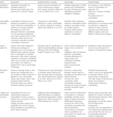
in an area with the same hazard intensity (e.g., 200 mm tephra thickness) may have different impact states (e.g. un-damaged, damaged gutters, collapsed roof) because of vari-ations in vulnerability. A set of fragility functions for tephra thickness describes the likely impacts across these buildings at 200 mm (and other tephra thicknesses). Whether vulner-ability or fragility functions are derived is dependent on the specifications of the vulnerability assessment and available Table 1Description, examples, advantages and disadvantages of different types of vulnerability assessments for volcanic hazards. Note that the advantages and disadvantages refer to the example implementation of the vulnerability assessments, not the approaches themselves
Name Description Implementation example Advantages Disadvantages
Qualitative descriptions
Qualitative description of probable impacts to infrastructure based upon the presence of a volcanic hazard.
Review and documentation of critical infrastructure impacts from historic eruptions (Wilson et al.2012a; Wilson et al.2014).
Detailed explanation of likely impacts and vulnerabilities for each infrastructure sector, highlighting potential mitigation strategies.
No indication of the differing levels of vulnerability at a particular site.
Difficult to compare multiple locations.
No spatial extent of vulnerability.
Vulnerability indicators
Vulnerability indicators are an attribute or property of a system which influences vulnerability or resilience to volcanic hazards. The degree to which this attribute influences vulnerability can be expressed qualitatively (e.g., high, medium, low) or with numerical values that can be summed to provide an overall vulnerability value/score.
Infrastructure vulnerability indicators to assess vulnerability to volcanic hazards on Vulcano Island, Italy (Galderisi et al.2012).
Identifies which attributes influence vulnerability and/or resilience, providing a basis for further research. Provides relative spatial distribution of areas of different vulnerability.
Assigning qualitative
descriptions or numerical values to indicators is subjective. Difficult to have common indicators and rankings for different spatial scales and different infrastructure designs.
Impact states (IS)
Impact state scales categorise infrastructure damage or disruption into a set number of defined states, typically ranging from no damage to complete destruction. Each state is typically assigned a numerical vulnerability value such as repair cost, damage ratio (repair cost relative to replacement cost) or percentage of damage.
Damage scale for classification of tephra induced building damage following 1991 Mt. Pinatubo eruption (Spence et al.1996).
Allows simple classification of impact into a number of states.
Highlights areas of relatively high/low vulnerability. Provides distribution of impact states and comparison between impacted areas. Easy to process post-eruption.
Qualitative impact descriptions do not cover all aspects of impact or infrastructure design.
Threshold levels
Similar to damage states in that impacts are categorised into a set number of states; however, in addition to the vulnerability values, each impact state is also assigned hazard intensity threshold values (e.g., tephra thickness, dynamic pressure).
Threshold level scales developed to indicate hazard intensity for each damage state for buildings and critical infrastructure (Spence et al.2004; Jenkins et al.2014b, Wilson et al.2014).
Provides a relationship between impact state (i.e., damage and disruption) and hazard intensity.
Accounts for some uncertainty within vulnerability estimates through the range of hazard intensity threshold values provided.
Selected hazard intensity metrics may not be appropriate to estimate impacts for all infrastructure components. The wide range of infrastructure design and operation
characteristics influences vulnerability.
Fragility and vulnerability functions
Quantitative functions (i.e., mathematical equations). Vulnerability functions express relative loss or economic cost to hazard intensity.
Fragility functions express the probability of a level of impact being equalled or exceeded for a given hazard intensity.
Fragility functions developed for tephra fall impacts on buildings and electrical transmission systems (Spence et al.2005; Zuccaro et al.
2008; Wardman et al.2012b).
Impact intensity relationship is provided as a changing probability estimate over a range of hazard intensities. Mathematical approach accounts for some of the uncertainty associated with these assessments. The functions can directly inform quantitative risk assessments for impact and loss estimation.
Requires large statistically valid datasets for robust correlations. Selected hazard intensity metric may not be the most
appropriate to estimate impact for all infrastructure
components.
volcanic impact data. For volcanic risk assessment, the functions account for uncertainties (through probabilities) in the link between hazard intensity and damage (loss) upon which risk mitigation and management decisions are based. Functions can also be developed which consider mitigation actions, such as strengthening of components or clean-up, providing useful data for risk reduction cost-benefit analyses. Fragility functions are commonly used for earthquake (e.g., Porter et al. 2007), tsunami (e.g., Reese et al. 2011; Mas et al. 2012), mass movement (e.g., Quan Luna et al. 2011; Totschnig et al. 2011) and flood (e.g., Reese and Ramsay 2010; De Risi et al. 2013) vulnerability and risk assessments.
Existing volcanic vulnerability and fragility functions
Volcanology has fewer existing vulnerability and fragility functions than some other natural hazard fields (e.g., earth-quake). Reasons for this include: (1) limited data from which functions can be derived because the systematic col-lection and analysis of impact data for volcanic hazards is in its infancy (generally evolving post 1980 following the eruption of Mount St Helens); (2) infrastructure hazard as-sessments rarely account for volcanic hazards; (3) catastro-phe modelling by (re)insurance organisations often does not consider volcanic hazards; (4) there are no building or infrastructure design codes for volcanic impacts which would prompt the derivation of functions; and (5) volcanic eruptions are often infrequent events on human and infra-structure timeframes (Douglas 2007; Wilson et al. 2014). In addition, a range of intrinsic volcanic hazard properties can cause different impacts, leading to difficulties in deriving functions, for instance finer grainsize tephra will generally more rapidly block air filters compared to the same volume per unit area of coarser tephra. Despite these challenges, several vulnerability and fragility functions have been devel-oped for different volcanic hazards and critical infrastruc-ture (e.g., Blong 2003a; Douglas 2007; Jenkins and Spence 2009; Jenkins et al. 2013, 2014a, 2014b, 2015; Kaye 2007; Maqsood et al. 2014; Pomonis et al. 1999; Schriever and Hansen 1964; Spence et al. 1996, 2004, 2005, 2007; Valentine 1998; Wardman et al. 2012a; Wardman et al. 2014; Wilson et al. 2012a; Wilson et al. 2012b; Zuccaro et al. 2008; Zuccaro and De Gregorio 2013).
Key findings emerge from critical infrastructure im-pact (Blong 1984; Wilson et al. 2012a; Wilson et al. 2014) and volcanic fragility function literature:
1. A number of vulnerability and fragility functions are available for buildings for tephra fall (Spence et al.
2005; Kaye2007; Jenkins and Spence2009; Maqsood et al.2014), pyroclastic density currents (Spence et al.2007; Zuccaro et al.2008; Jenkins and Spence
2009) and lahar (Zuccaro and De Gregorio2013; Jenkins et al.2015) impacts.
2. There have been few (e.g., Kaye2007; Wardman et al.2012a; Wilson et al.2012a) attempts at
developing volcanic vulnerability and fragility functions for critical infrastructure sectors. This is primarily due to difficulties assessing vulnerability across a wide range of infrastructure types, designs, operating practices and societal pressures.
3. The majority of available volcanic vulnerability and fragility functions are derived for specific
infrastructure and building typologies. While this increases their accuracy for local risk assessments, these functions are difficult to apply in other locations. Indeed, several authors have argued for the need to customise vulnerability and fragility functions to the study area to ensure accuracy (i.e. Jenkins et al.2014a; Wilson et al.2014).
Nevertheless there is an increasing requirement for regional or global volcanic risk and vulnerability assessments (e.g. the UNISDR Global Assessment of Risk; Jenkins et al.2014b), thus derived functions need to account for a range of infrastructure typologies or assume generic typologies. 4. There are limited quantitative empirical
(post-eruption impact assessments and laboratory
experiments), analytical or theoretical data to inform the development of volcanic fragility or vulnerability functions for critical infrastructure sectors.
5. A number of semi-quantitative impact state scales are available (e.g., Spence et al.2004; Jenkins et al.
2014b; Wilson et al.2014; Jenkins et al.2015) from which vulnerability and fragility functions could be derived given sufficient impact data.
6. There is a reasonable amount of qualitative vulnerability data available, primarily from post-eruption assessments, which can be used to inform quantitative volcanic vulnerability assessments.
What is currently missing is a methodology to com-bine qualitative and quantitative data to develop quanti-tative vulnerability estimates for critical infrastructure sectors. We address this gap here with a new volcanic vulnerability framework, which provides a method to use all available vulnerability data to derive vulnerability and fragility functions.
2014a) and tsunami (e.g., Tarbotton et al. 2015) vulnerabil-ity assessments.
Impact data
The data used to derive vulnerability and fragility func-tions is henceforth termed impact data. Impact data re-lates infrastructure impact to hazard intensity and can be classified into four main groups: empirical; expert judgment; analytical; and hybrid (Table 2).
A brief discussion of combining impact datasets (hybrid data) is warranted as this is the most likely approach for deriving volcanic fragility functions given the limited avail-ability of impact data. Dataset are often combined to ob-tain sufficient data to derive fragility functions; care is required to do this appropriately as there will be different biases, sources and magnitudes of uncertainty amongst datasets (Calvi et al. 2006); this discrepancy can influence the quality of the resulting function(s).
In the case of post-eruption impact assessment data, there may be many different datasets available for nu-merous eruptions and locations, all of which could be of
variable detail and quality. Rossetto et al. (2014b) sug-gests that prior to combining datasets, impact data should be harmonised by assuring that: (1) data type are of the same form, e.g., if one dataset is at building-by-building scale and another contains grouped data (e.g., multiple buildings in one area), the more detailed data should be aggregated to the grouped scale; (2) building and infrastructure typologies are consistent among data-sets, if not, the most general typologies should be used; and (3) impact scales are identical across datasets, if not, a conversion to the coarsest scale (i.e., the scale with the least levels) should occur. Ensuring consistency among the different datasets permits more meaningful deriv-ation of vulnerability and fragility functions. We recom-mend using standard infrastructure impact scales such as the recently developed Level 0–3 damage and disrup-tion categories for tephra fall, PDCs, lava flows, and la-hars (Wilson et al. 2014) for future post-eruption impact assessments and function derivation. However, we note that damage/impact states for other hazards such as earthquakes, cyclones/hurricanes and tsunami are often classified on alternative scales (e.g. Damage Level cat-egories of 0–5), as are previous volcanic damage/impact states (e.g. Blong 2003c, Baxter et al. 2005). Therefore, additional analysis may be required to correlate previous work with Wilson et al.’s (2014) four-tier scale.
Due to differences in impact data quality we propose a qualitative quality rating system to indicate the quality of data for different infrastructure components and sec-tors (Table 3). To reduce uncertainties, high quality data should be preferentially used to derive volcanic vulner-ability and fragility functions.
Impact metrics (IM)
An impact metric (IM) is used to assess the volcanic im-pact (e.g., damage) intensity for a particular infrastructure component or sector. IMs are commonly bounded be-tween 0 and 1 or 0–100 and are the dependent variable of vulnerability and fragility functions. For vulnerability func-tions, the IM can be a value or index which describes im-pact or economic loss. Any IM can be used for a vulnerability function depending on applicability and justi-fication. Common IMs for vulnerability functions are:
1. Damage percentage–percentage of damage
sustained by an asset compared to pre-impact condi-tion (e.g., a building is 90% damaged after a lahar impact).
2. Loss of function–loss of function of an asset as a percentage compared to pre-impact condition (e.g., a water treatment plant lost 20% of its function after a tephra fall).
3. Damage index–damage percentage normalised between 0 and 1.
4. Function loss index–loss of function percentage normalised between 0 and 1.
5. Damage ratio–a ratio between the cost of repair relative to the cost of replacement.
6. Economic cost–absolute cost of impact(s) in monetary value.
7. Impact state (IS)–states of damage and disruption defined by semi-quantitative impact descriptions (see the four level impact scale of Wilson et al. (2014)).
The IM for fragility functions is the probability of an asset equalling or exceeding a specified level of impact. Typically, the level of impact is defined by ISs with one function defined for each IS (i.e., a set of fragility func-tions) or only for the highest IS. As such, the fragility function gives the probability of equalling to or exceed-ing theith IS. Given that ISs are sequential, such that ISi
implies that ISi-1 has occurred, the probability of being
equal to a specific IS can be calculated by the difference between consecutive ISs.
Hazard intensity metrics (HIM)
A hazard intensity metric (HIM) describes the intensity of a volcanic hazard at a particular site. It is the independent variable of vulnerability and fragility functions. Volcanic hazards have a number of different properties which can convey intensity, as not all HIMs adequately capture all of the impactful attributes of volcanic hazards (Wilson et al. 2014). Therefore, the selection of an appropriate HIM is important. As discussed in Wilson et al. (2014), the selec-tion of a HIM must consider: (1) the HIM’s appropriateness to describe a range of infrastructure impact intensities; (2) the ease of HIM measurement in the field or laboratory; (3) the applicability of the HIM to hazard model outputs; and (4) which HIM has been used in existing impact datasets. The most common HIMs are (Wilson et al. 2014): thick-ness or mass loading (tephra fall, PDC deposits, lahar de-posits), dynamic pressure (PDC, lahar), flow height (lava flow, lahar), presence or absence (lava flow, gas emissions), density per unit area (ballistics), impact energy (ballistics) and concentration (gas emissions, tephra fall).
Table 2Classification, advantages and disadvantages of volcanic impact data used to derive fragility and vulnerability functions. Modified from Schultz et al. (2010) and Wilson et al. (2014)
Data classification Data type Advantages Disadvantages
Empirical Post-eruption impact assessments Laboratory experiments
Range of volcanic hazard and infrastructure characteristics taken into account
Previous impacts are likely to occur again in the future
Repeatable experiments in controlled conditions
Data highly site, region, infrastructure specific Scarce data of variable quality
Difficulties in replicating volcanic hazards in laboratory
Expert judgement
Expert elicitation Consider a wide range of impacts, including those not previously observed
Not limited by impact data or models Can be used to refine and update existing functions
Widely accepted elicitation methods available
Quality depends on subjectivity and expertise, particularly if experience consists of atypical eruption impacts Can be difficult to validate
Differing and contradictory opinions
Analytical Numerical modelling
Increased reliability and repeatability and reduced bias
Models can be validated against post-eruption impact data
Can be extrapolated to new situations
Substantial computation may be required for more complex modelling
Models based on simplifications and assumptions
Hybrid Combination of different approaches
Can reduce limitations and uncertainties through the combination of different data types
Limitations are the same as individual approaches Differences in data scale and aggregation (see text)
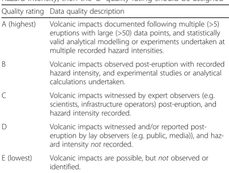
Table 3Data quality ratings to evaluate the quality of volcanic vulnerability data. We suggest that a precautionary approach should be taken where data could fall within two categories, assigning that data the lower quality rating option. For example, if a scientist witnesses an eruption but does not record the hazard intensity, then the‘D’quality rating should be assigned Quality rating Data quality description
A (highest) Volcanic impacts documented following multiple (>5) eruptions with large (>50) data points, and statistically valid analytical modelling or experiments undertaken at multiple recorded hazard intensities.
B Volcanic impacts observed post-eruption with recorded hazard intensity, and experimental studies or analytical calculations undertaken.
C Volcanic impacts witnessed by expert observers (e.g. scientists, infrastructure operators) post-eruption, and hazard intensity recorded.
D Volcanic impacts witnessed and/or reported post-eruption by lay observers (e.g. public, media)), and haz-ard intensitynotrecorded.
Function derivation
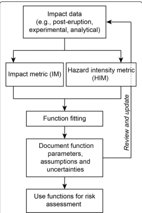
Volcanic vulnerability and fragility function derivation requires: (1) data curation to convert raw impact data into a form which can be used for function derivation; and (2) a method to fit functions to available data.
Data preparation
Data preparation is generally required to derive volcanic vulnerability and fragility functions. For vulnerability functions, each data point needs to have a hazard inten-sity metric (HIM) value and an inteninten-sity metric (IM) value. For fragility functions, each data point needs to have a HIM value and an impact state (IS) level (a spe-cific type of IM; Table 4). For the latter, data are ordered by increasing HIM value and binned, such that each bin has approximately the same number of data. The prob-ability of equalling to or exceeding each IS can be calcu-lated for each HIM bin. This is achieved by summing the number of data points which are greater than or equal to the IS of interest relative to the number of data points that are assigned to lower IS’s (Fig. 2 for an ex-ample). Discrete HIM values are obtained by taking the median of each HIM bin. This method is commonly used to derive fragility functions for earthquake (Porter et al. 2007) and tsunami (Tarbotton et al. 2015) hazards. Despite the sparsity of quantitative data for volcanic im-pacts, the approach to bin the HIM values was adopted to produce a framework that is consistent with those used for other hazards. Additionally, by using this ap-proach, initial fragility functions derived for volcanic hazards can be easily interpreted and modified as more data becomes available. The initial fragility function de-velopment will also highlight where particular impact data is lacking, identifying areas where analytical data, and empirical data collected through targetted labora-tory experiments, can assist.
Function fitting
Any number of discrete or continuous mathematical functions can be fitted to impact data to obtain volcanic vulnerability and fragility functions. While in the earth-quake community there are guidelines for best-practice function form (Rossetto et al. 2014b), there is no equiva-lent in the volcano community. In volcanology, the good faith practice is that selected functions represent the data appropriately. In data-poor contexts, these often take on binary or piecewise linear forms.
The simplest approach is using a binary function, such that below some hazard intensity threshold impact does not occur and above the threshold, impact occurs. For example, if lava is present, an asset (e.g., a road) may be considered completely destroyed whereas if lava is ab-sent, the asset is undamaged.
Volcanic vulnerability and fragility functions can be described by linear equations applied to either the whole dataset or to individual segments; this is our preferred method for limited datasets. The start and end point of each line segment is defined by the available data points after the HIM binning process. In our function deriv-ation examples below, we took this approach because only three HIM bins could be reasonably applied to the limited volcanic impact data; using a complex mathem-atical equation to interpolate between three data points was unjustified. Eq. 1 shows the form of the piecewise linear equation used to calculate the probability of theIS equalling or exceeding theithIS:
P ISð ≥ISiÞ¼
f
0
m1;i HIM
þc1;i m2;i
HIM þc2;i m3;iHIMþc3;i
HIM¼0
k1<HIM≤k2
k2<HIM≤k3
k3>HIM
wherem1,i,m2,iand m3,iare slope constants and c1,i,c2,i and c3,iare intercept constants for three linear segments for thei-thIS. Constantsk1,k2andk3,wherek1≠k2≠k3, are critical HIM values for which the different linear seg-ments apply. Other mathematical equations, such as ex-ponential and polynomial, can be used to define vulnerability and fragility functions; however, care must be taken with these and with linear equations, as they are unbounded on the x-axis and y-axis and could result in negative values or probabilities >1.
A note on normal and lognormal cumulative distribu-tion funcdistribu-tions (CDFs), commonly used in earthquake and tsunami fields to define infrastructure fragility func-tions (Rossetto et al. 2013; Tarbotton et al. 2015), is war-ranted. Porter et al. (2007) and Rossetto et al. (2013) note desirable properties of lognormal CDFs for fragility function derivation are that: (1) the function is con-strained on the y-axis between 0 and 1, which is ideal for fitting probabilities bounded in this range; (2) the x-axis is constrained between 0 and +∞, which prevents negative hazard intensities; and (3) lognormal CDFs are skewed to the left which better represents earthquake damage data clustered around low hazard intensities. In volcanology, lognormal CDFs have been used for fragility functions for building damage as a result of tephra fall and ballistics (e.g., Spence et al. 2005; Jenkins and Spence 2009; Jenkins et al. 2014a; Blong et al. 2017) based on how well it represents building impact data and its use for earthquake hazards.
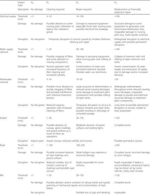
Table 4Impact states for expected impacts to critical infrastructure as a function of tephra fall thickness. Modified and updated from Wilson et al. (2014)
Impact State
IS0 IS1 IS2 IS3
Description No damage Cleaning required Repair required Replacement or financially expensive repair
Electrical supply Threshold (mm)
<3 3–10 10–100 >100
Damage No damage Possible abrasion to some moving parts, infiltration of tephra into substation gravel.
Damage to exposed equipment especially those with moving parts, possible electrical line breakage.
Structural damage to some equipment at generation and transmission/distribution sites, irreparable damage to moving parts (e.g., hydro power turbines).
Disruption No disruption Temporary disruption to service caused by insulator flashover, cleaning and repair.
Widespread disruption to electrical supply with possible permanent disruption.
Water supply network
Threshold (mm)
<1 1–20 20–100 >100
Damage No damage Possible clogging of filters and some abrasion to moving components.
Damage to pumping equipment, other moving parts and infilling of tanks.
Collapse of reservoir roofs and infilling of open reservoirs and tanks.
Disruption No disruption Normal operation with increased frequency of filter cleaning and increased turbidity.
Contamination of water and increased treatment required. Possible water use restrictions.
Severe contamination of water supply and exhaustion of supply due to damage and/or increased demand.
Wastewater network
Threshold (mm)
<3 3–10 10–50 >50
Damage No damage Possible minor abrasion to pumps, clogging of filters and possible interference with chemical treatment process.
Large amounts of sedimentation in network some causing blockages, some damage to treatment plant components and possible infilling of open tanks.
Widespread sedimentation throughout entire network causing some blockages, irreparable damage to pumps and extensive structural damage to treatment plant components.
Disruption No disruption Reduced capacity, operation with increased cleaning of filters.
Temporary disruption to service to unblock network and clean tanks possibly resulting in discharge of untreated sewage.
Long term to possible permanent disruption to service. Unable to treat wastewater.
Airport Threshold (mm)
<1 1–30 30–150 >150
Damage No damage Possible abrasion of runway, apron markings and paved surfaces as a result of clean-up operations.
Moderate abrasion of paved surfaces and landing lights.
Complete burial.
Disruption Airport open Airport closure, reduced visibility and traction. Possible permanent closure.
Road Threshold
(mm)
<1 1–100 100–250 >250
Damage No damage Possible increased abrasion of road markings and paved surfaces.
Weak bridges may experience structural damage.
Complete burial, structural damage to some bridges.
Disruption No disruption Reduced visibility, loss of traction, covering of markings and possible road closure.
Roads impassable for some vehicles.
Roads impassable if tephra is unconsolidated, compacted tephra may be driven on by some vehicles. Likely road closures.
Rail Threshold
(mm)
<1 1–30 30–150 >150
No damage Possible abrasion and/or corrosion of railway tracks and signals, jamming of mechanical signals and contamination of track ballast.
Complete burial
(2015), Tarbotton et al. (2015) and references therein for discussion and review of statistical data fitting tech-niques. Expert judgment can also be used to fit functions to limited or incomplete datasets or when simplifying complex problems, which is often required in volcan-ology. For expert judgment to be reproducible and trans-parent, we offer a list of guidelines for fitting functions to volcanic impact data using statistical data fitting tech-niques. These guidelines are not required when suffi-cient data are available to derive vulnerability estimates (e.g., earthquake vulnerability assessment), but are vital in volcanology where there are limited data to base vul-nerability estimates on.
1. Individual functions in a set are sequential, such that ISi+1is never reached beforeISi. This allows the
progressive accumulation of impact. For example, a building impacted by a PDC would not experience complete destruction and then experience damage to openings from missile impact. However, transitions along the IS sequence may be instantaneous and prior ISs may be omitted
completely (e.g. during a lahar, a well-sealed building with few openings may not experience any infiltra-tion of debris before complete damage).
2. Individual functions in a set can converge but not intersect. Intersecting functions violate the rule of sequential functions.
3. A probability of 0 means impacts will never occur and conversely a probability of 1 means impacts will certainly occur.
4. No impacts occur when the HIM value is zero. This rule assumes normal infrastructure operation in the absence of volcanic hazards.
5. Functions are non-decreasing, i.e., functions do not decrease as the HIM value increases. This rule as-sumes the impact intensity is constant or becomes more intense as volcanic hazard intensity increases. 6. Pre-condition (e.g., maintenance, age) of
infrastructure sites can influence their vulnerability to volcanic hazards and functions should be modified for specific individual sites. 7. Factors such as equipment typology, level of
preparedness, mitigation strategies can influence volcanic vulnerability and functions should be tailored to individual infrastructure sites on a case-by-case basis to address these site specific factors. 8. Different impact mechanisms can influence volcanic
vulnerability and the interaction or dominance of different volcanic hazard impact mechanisms and should be considered.
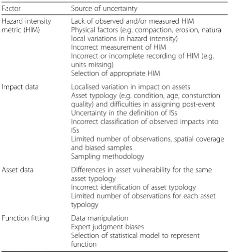
Uncertainty analysis
There are a number of uncertainties which influence the quality of vulnerability and fragility functions (Table 5). Aleatoric (statistical) uncertainty is introduced by the nat-ural variation of volcanic eruptions, hazard occurrence, or the variation of infrastructure response to volcanic hazards. Table 4Impact states for expected impacts to critical infrastructure as a function of tephra fall thickness. Modified and updated from Wilson et al. (2014)(Continued)
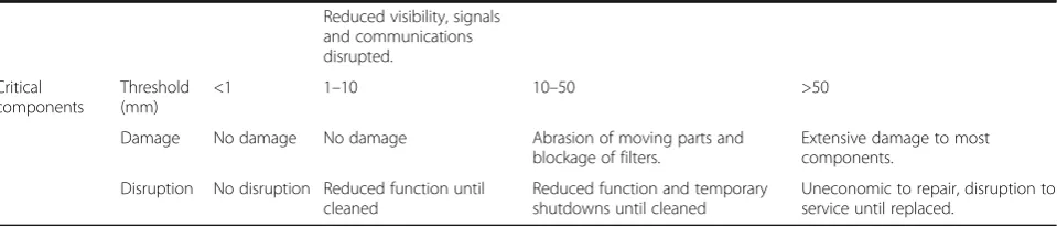
Reduced visibility, signals and communications disrupted.
Critical components
Threshold (mm)
<1 1–10 10–50 >50
Damage No damage No damage Abrasion of moving parts and blockage of filters.
Extensive damage to most components.
Disruption No disruption Reduced function until cleaned
Reduced function and temporary shutdowns until cleaned
Uneconomic to repair, disruption to service until replaced.
Different sources of epistemic (systematic) uncertainty are associated with HIMs and the volcanic impact dataset (Ros-setto et al. 2014a). As single HIMs cannot adequately de-scribe all the impactful aspects of a particular hazard, a compromise is made when selecting a HIM for vulnerabil-ity and fragilvulnerabil-ity functions introducing uncertainty. This could be overcome by deriving multiple volcanic function sets for different HIMs or combining multiple HIMs. In addition, most volcanic HIMs cannot be measured in real time and rely on measurements taken after an event, eye-witness reports, and inference from volcanic deposits or impacts. For example, it is difficult to measure dynamic pressures of PDCs due to their potential to cause injury and destroy measurement equipment; therefore, the dy-namic pressure is typically estimated from deposits or resulting asset damage (e.g., Jenkins et al. 2013). This can lead to large uncertainties in the measurement of volcanic hazard intensity (e.g., Engwell et al. 2013).
Large sources of uncertainty within volcanic impact data arise from the classification of impacts into ISs and the often small sample size. The number of observations in volcanic impact datasets can affect data interpretation and statistical analysis. Currently this is a large source of uncertainty for volcanic hazard vulnerability and fragility functions, with many datasets containing few data (~10s of data points). As a comparison, for earthquake fragility functions, Rossetto et al. (2014b) consider ~30 buildings for each building class as a minimum for function deriv-ation, with best practice involving >100 buildings.
Regardless of the source of uncertainty or its magnitude, identification, minimisation and quantification of all un-certainties should be undertaken. Rossetto et al. (2014a) considers this a fundamental step in the derivation of vul-nerability and fragility functions for infrastructure assets.
For the volcanic fragility functions derived in the fol-lowing sectionVolcanic Tephra Fall Fragility Functions, uncertainty is accounted for at each HIM value by calcu-lating the probability that an infrastructure site could be in one of four ISs. Variation in the HIM value is taken into account by binning these values and using the me-dian bin value as discrete HIM values on each fragility plot. Other approaches, such as the use of confidence in-tervals (e.g., 5th and 95th percentiles), could be used to account for uncertainties, particularly with large data sets where these intervals can be statistically estimated.
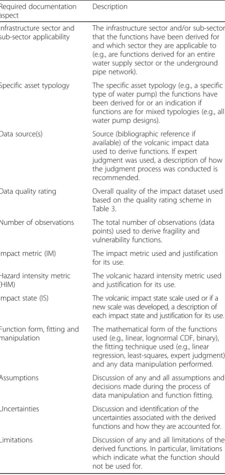
Documentation
Documentation of volcanic vulnerability and fragility functions is critical for their reproducibility, reliability and implementation. Users must understand what the functions show, how they were derived, their limitations and applicability. Transparency and understanding can be achieved by documenting the aspects in Table 6 for each (or set of ) vulnerability and fragility function(s) for volcanic hazards. Documentation also provides the basis for review and updating of functions when further vol-canic impact data becomes available.
Tephra fall fragility functions
Overview
In this section we present fragility functions for discrete tephra fall impacts to the electricity supply, water sup-ply, wastewater and transport networks using the meth-odology outlined in the first half of this paper; Additional file 1 provides equations for all functions derived here. Buildings are not included here as a num-ber of studies (e.g., Spence et al. 2005; Zuccaro et al. 2008; Jenkins and Spence 2009; Maqsood et al. 2014) have already derived fragility functions for different building typologies. The approach is transferable to other assets such as people and agriculture where im-pact data exists for certain localities (e.g. taking account of cultural or climatic factors specific to that region and hence the vulnerability of the asset). We focus on tephra fall as it is the most common and widespread volcanic hazard (Wilson et al. 2012a) and there are more tephra fall impact data available with which to de-rive fragility functions. We use tephra thickness as the HIM as it is the most commonly recorded HIM. Our fragility functions describe the probability of equalling or exceeding one of four ISs defined by Wilson et al. (2014) as: IS0–no damage; IS1–cleaning required; IS2 – repair required; and IS3– replacement or financially
Table 5Sources of error and uncertainty for volcanic fragility and vulnerability functions
Factor Source of uncertainty
Hazard intensity metric (HIM)
Lack of observed and/or measured HIM Physical factors (e.g. compaction, erosion, natural local variations in hazard intensity)
Incorrect measurement of HIM
Incorrect or incomplete recording of HIM (e.g. units missing)
Selection of appropriate HIM
Impact data Localised variation in impact on assets Asset typology (e.g. condition, age, consturction quality) and difficulties in assigning post-event Uncertainty in the definition of ISs
Incorrect classification of observed impacts into ISs
Limited number of observations, spatial coverage and biased samples
Sampling methodology
Asset data Differences in asset vulnerability for the same asset typology
Incorrect identification of asset typology Limited number of observations for each asset typology
Function fitting Data manipulation Expert judgment biases
expensive repair (Table 4). Functions were fit using segmented linear equations and modified with expert judgment where functions violate data fitting rules (see section Function Fitting). Additional file 2 highlights vulnerable components and key knowledge gaps for each sector.
Caveats
The following caveats apply to all fragility functions here:
1. Presented fragility functions only consider generic infrastructure design and typology due to limited vulnerability data on specific typologies.
Vulnerability will be different when considering different typologies and sites; therefore, functions should be tailored on a site-by-site basis.
2. Interdependencies between infrastructure sectors are not considered; the vulnerability of each sector is assessed in isolation. Interdependencies between sectors are complex, often with multiple and bi-directional failure modes. For example, transporta-tion may rely on continuous electricity for traffic sig-nals, but the electricity network may rely on
transportation for generator fuel supply (Rinaldi et al.2001, Blake2016). Interconnected systems create benefits during normal operation, but can bring vul-nerabilities and challenges when natural hazards are encountered (Hughes and Healy2014, Blake2016) and will likely influence overall vulnerability. 3. Presented fragility functions only consider discrete
tephra fall events and not prolonged, reoccurring or remobilised tephra falls, nor clean-up and restor-ation of infrastructure sectors following tephra fall. 4. Cumulative multi-hazard effects are not considered,
and some assets may encounter multiple impacts with different intensities from various volcanic or other natural hazards.
5. Mitigation actions are not considered.
Electricity supply network
Electricity supply networks comprise electricity gener-ation sites, substgener-ation sites and transmission networks. These three sub-sectors differ in the type of equipment used and resulting tephra impact mechanisms and are therefore considered separately. Commonly observed tephra fall induced impacts are: insulator flashover; breakage of transmission lines; abrasion of turbines and cooling systems at generation sites; and disruption of service at substations (Wardman et al. 2012a).
Available tephra fall vulnerability data
The majority of the vulnerability data for electrical net-works impacted by tephra falls comes from post-eruption impact assessments. There are data for at least 10 eruptions dating back to the 1980 Mt. St. Helens eruption; summarised by Wardman et al. (2012a) and Wilson et al. (2014). The majority of these data report impacts to transmission and distribution networks, al-though there are some data for generation and sub-station sites. The data are primarily qualitative and document disruption and damage as a function of tephra fall intensity. Wardman et al. (2014) conducted system-atic laboratory experiments to determine the probability of insulator flashover as a function of tephra thickness Table 6Required documentation for volcanic vulnerability and
fragility function(s) Required documentation aspect
Description
Infrastructure sector and sub-sector applicability
The infrastructure sector and/or sub-sector that the functions have been derived for and which sector they are applicable to (e.g., are functions derived for an entire water supply sector or the underground pipe network).
Specific asset typology The specific asset typology (e.g., a specific type of water pump) the functions have been derived for or an indication if functions are for mixed typologies (e.g., all water pump designs).
Data source(s) Source (bibliographic reference if available) of the volcanic impact data used to derive functions. If expert judgment was used, a description of how the judgment process was conducted is recommended.
Data quality rating Overall quality of the impact dataset used based on the quality rating scheme in Table3.
Number of observations The total number of observations (data points) used to derive fragility and vulnerability functions.
Impact metric (IM) The impact metric used and justification for its use.
Hazard intensity metric (HIM)
The volcanic hazard intensity metric used and justification for its use.
Impact state (IS) The volcanic impact state scale used or if a new scale was developed, a description of each impact state and justification for its use.
Function form, fitting and manipulation
The mathematical form of the functions used (e.g., linear, lognormal CDF, binary), the fitting technique used (e.g., linear regression, least-squares, expert judgment) and any data manipulation performed.
Assumptions Discussion of any and all assumptions and decisions made during the process of data manipulation and function fitting.
Uncertainties Discussion and identification of the uncertainties associated with the derived functions and how they are accounted for.
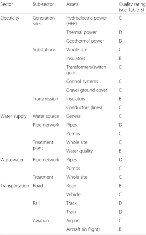
and moisture content. Experiments to document flash-over were conducted in a controlled environment using different insulator types common in New Zealand with both dry and wet tephra. Other experimental research on tephra induced insulator flashover was conducted by Nellis and Hendrix (1980) and Matsuoka et al. (1995). Laboratory experiments by Zorn and Walter (2016) ex-amined changes in solar panel performance as a function of increasing tephra thickness; however, this study is limited in scope (i.e., only examined horizontal panels) and is not applied here. We assess and summarise the quality of the available vulnerability data for electrical generation sites, substations and transmission networks in Table 7 based on the scale presented in Table 3.
Fragility functions
Electricity generation Tephra can affect electricity
gen-eration through impacts to the cooling systems of ther-mal power stations and through abrasion of hydroelectric power (HEP) turbines. These impacts can cause disruption to electricity generation.
Due to the size and scale of equipment used at electri-city generation sites, no experiments have been under-taken to systematically determine the vulnerability of these to tephra fall. Thus, the fragility functions pre-sented here are based on post-eruption impact assess-ment data. Twelve case studies docuassess-menting impacts to different generation types are available; Fig. 3a shows that the majority are classified as IS1(cleaning required)
with no documented cases of IS3(replacement or
finan-cially expensive repair).
Impact mechanisms for the three generation types (hydroelectric, thermal and geothermal) considered here are fundamentally different; however, there are insuffi-cient data to derive separate fragility functions for each generation type. Therefore, all data are used, with expert judgment to avoid violating data fitting rules, to derive a set of fragility functions (Fig. 3b) for mixed-generation types (i.e., all hydroelectric, thermal, and geothermal generation). While no available case studies document impacts at IS3, we assume they are likely to occur in
fu-ture eruptions and therefore IS3 has been included in
the fragility function with a probability 0.2 for the 51– 300 mm bin (based on expert judgement). See Wardman et al. (2012a) for a full treatment of tephra fall impacts to power stations.
Substations Substations are vulnerable to tephra fall
primarily due to flashover on insulators and energised components, ash contamination causing reduced resist-ivity of gravel ballast in substation yards (and thus in-creasing step-touch potential), and blockage of transformer cooling systems (Wardman et al. 2012a).
There are 16 post-eruption impact assessments available. We are unaware of any experimental data for substation components. The majority of the post-eruption impact data are classified as IS1(cleaning required; Fig. 4a) as a
result of operators cleaning gravel ground cover or sen-sitive equipment such as transformers. Few instances of substation impact ≥IS2 have been documented due to
precautionary shut-downs for cleaning (Fig. 4a). How-ever, like generation sites, IS3is likely to occur in future
eruptions and is therefore estimated with a probability 0.2 for the 51–300 mm bin (Fig. 4b), again based on ex-pert judgement at this stage.
Electricity transmission lines Electricity transmission
lines are vulnerable to tephra fall resulting in temporary or permanent disruption of electricity supply. The ma-jority of the 24 post-eruption impact data points are classified as requiring cleaning (IS1) to be reinstated
Table 7Quality rating of available tephra fall impact data for considered sectors
Sector Sub-sector Assets Quality rating
(see Table3)
Electricity Generation sites
Hydroelectric power (HEP)
C
Thermal power D
Geothermal power D
Substations Whole site C
Insulators B
Transformers/switch gear
C
Control systems C
Gravel ground cover C
Transmission Insulators B
Conductors (lines) C
Water supply Water source General C
Pipe network Pipes D
Pumps C
Treatment plant
Whole site C
Water quality B
Wastewater Pipe network Pipes D
Pumps C
Treatment Whole site C
Transportation Road Road B
Vehicle C
Rail Track D
Train D
Aviation Airport C
(Fig. 5a). Disruption is typically caused by flashover (the most common impact observed; Wardman et al. 2012a), controlled shutdowns to prevent damage, and cleaning of equipment. Physical damage such as line breakage (IS2) has been documented in three previous eruptions
(Wardman et al. 2012a). More intense damage (IS3) has
not been documented, although could reasonably occur in future eruptions. In addition to these post-eruption impact data, Wardman et al. (2012a) and Wardman et al. (2014) conducted laboratory experiments to investi-gate what volume and characteristics of tephra led to flashover on high voltage (HV) insulators. Insulator flashover is classified as IS1, and therefore, we used the
Wardman et al. (2012a) flashover fragility function to in-form and modify the IS1 function (Fig. 5b). The set of
functions in Fig. 5b are derived from all known impacts to transmission lines and estimate the probability of each ISs as a function of tephra thickness. We note that the functions do not specifically account for tephra moisture at this stage, however it should be noted that flashover probability is increased when tephra is wet (Wardman et al. 2012a).
Water supply networks
Water supply networks include water source areas (rivers, lakes, and groundwater), water treatment, storage facilities and distribution networks (above or below ground). Im-pacts commonly caused by tephra fall are: changes in water quality (chemical and turbidity); increased water de-mand (typically for tephra clean-up); abrasion of pumps; and blockage of filters at treatment plants. See Stewart et al. (2010) and Wilson et al. (2014) for further discussion of impacts to water supply networks.
Available tephra fall vulnerability data
turbidity) through numerical modelling and laboratory ex-periments. We are unaware of any quantitative studies on the physical impacts of tephra fall to water treatment plants (WTP) and pipe distribution networks. We assess and sum-marise the quality of the available vulnerability data for water supply sources, pipe networks and treatment plants in Table 7 based on the scale presented in Table 3.
Fragility functions
Tephra fall can impact water supply networks causing both disruption and physical damage. Analysis of post-eruption impact data shows that the most common im-pact intensity is IS2 followed by IS1 (Fig. 6a). There is
one instance of IS3 from Pacaya where above-ground
pipes suffered damage from large tephra particles (Wardman et al. 2012b). Because there is only one in-stance of pipe damage, the set of fragility functions we derive here are for individual WTPs and not pipe net-works. Water supply pipe networks are likely to be more resilient to tephra fall impacts as they are commonly underground and ingestion of tephra contaminated water is avoided; further research is required to confirm
this. However, tephra deposited into water sources may be transported through the pipe network into the WTP, which could result in pipe damage. Tephra arriving at the WTP from the pipe network or from tephra contam-inated subaerial reservoirs will likely increase system vulnerability.
The functions in Fig. 6b reflect only direct tephra fall impact at a water treatment plant. Fig. 6b shows that for thin tephra falls there is a higher probability of tolerance (IS0) and disruption type impacts (IS1). As tephra
thick-ness increases there is a higher probability of a water treatment plant being at IS2, reflecting the higher
occur-rence of these impacts during previous eruptions. While there are limited data to assess the probability of IS3, we
assume that as tephra thickness increases, the probabil-ity of IS3 will also increase as a result of the increase
likelihood of tephra induced abrasion of pumps. Abra-sion damage on pumps and other mechanical compo-nents is more likely at tephra thicknesses ≥30 mm than <30 mm (Wilson et al. 2014).
occur is not accounted for. These impact types are con-trolled by the tephra concentration (or‘dose’) that com-ponents are exposed to over time, which is currently poorly understood and very sensitive to any mitigation measures applied. Therefore, discretion must be used when applying Fig. 6b functions as higher ISs (IS2, IS3)
are likely to occur sometime after a tephra fall event. In addition, WTPs can be highly specialised and specifically designed for the local/regional water characteristics. Each of the 20 post-eruption instances of water supply impact occurred at a WTP with different designs and layouts, and the subtlety of these differences is lost in deriving these functions (Fig. 6b). Therefore, we recom-mend that fragility functions for WTP be derived specif-ically for each water treatment site on a case-by-case basis to improve vulnerability assessments.
Wastewater treatment network
Wastewater networks comprise a network of under-ground collection pipes, pumps above-under-ground treatment facilities, and discharge pipes. Wastewater networks may be combined with stormwater systems or the two may
be completely separate, with the former configuration increasing the overall network vulnerability as tephra can be ingested directly into the network (Barnard 2009). Impacts commonly caused by tephra fall are: abrasion of pumps and mechanical components; pipe blockages; and treatment disruption (collapse of bio-logical processes) which could result in the bypassing of untreated wastewater. See Wilson et al. (2014) for fur-ther discussion of impacts to wastewater networks.
Available tephra fall vulnerability data
settings. While these experiments cannot be directly compared to wastewater pumps, they can provide insight as to the potential impacts and guide any expert judg-ment. We assess and summarise the quality of the avail-able vulnerability data for wastewater pipe networks and wastewater treatment plants (WWTP) in Table 7 based on the scale presented in Table 3.
Fragility functions
Available post-eruption impact data shows that the most common impact intensities are IS1 and IS2 (Fig. 7a). IS3
has been documented at tephra thicknesses between 5 and 25 mm after the 1980 Mt. St. Helens eruption. In this case the Yakima WWTP suffered severe abrasion damage to pumps and pumping components and the treatment plant was bypassed which resulted in the discharge of un-treated waste into the Yakima River (Blong 1984). While these impacts are documented as occurring with tephra thicknesses between 5 and 25 mm (given by isopach maps), significantly more tephra likely passed through the treatment plants as tephra was washed into the
stormwater network (Blong 1984). Therefore, the prob-ability of exceeding IS3increases as tephra thickness
in-creases (Fig. 7b). However, for thicknesses >10 mm, there is a higher probability of a site being at IS2. This trend is
influenced by the post-eruption impact data which contain a number of older wastewater networks which are com-bined with stormwater networks. Tephra can enter storm-water networks though drainage systems, introducing additional tephra into the wastewater treatment plant, leading to increased impact at lower recorded tephra thicknesses. This limitation of the derived functions is dif-ficult to overcome with available data which does not rec-ord volume of tephra entering a treatment facility. By obtaining additional data which combines tephra volume and exposure time, vulnerability assessments will improve; however, this data is difficult to obtain.
through direct air fall. As there is a limited under-standing of how tephra enters and moves through wastewater pipe networks, the fragility functions in Fig. 7b are derived only for individual treatment sites and do not consider the influence of tephra entering through the pipe network.
Transportation networks
Transportation networks include those on land, air and sea. Transportation networks typically include large ex-pansive linear components (e.g., roads, railways), nodes (e.g., airports, ports) and vehicles (e.g., cars, trains). This section does not consider impacts to the marine sector, vehicles, trains, aircraft or support buildings (e.g., airport terminals and train stations). Impacts commonly caused by tephra fall include: reduction in visibility and traction; covering of roads and runways; and vehicle damage (windscreen and chassis abrasion, filter blockage, seized engines). See Wilson et al. (2014), Blake (2016) and Blake et al. (2016; 2017a, b) for further discussion of impacts to transportation.
Available tephra fall vulnerability data
the skid resistance (traction) and visibility of road mark-ings on road surfaces covered by ash of different charac-teristics. Blake (2016) also conducted experiments quantifying visibility reduction during tephra falls. How-ever, this paper does not incorporate results from these latest laboratory tests.
We assess and summarise the quality of the available vulnerability data for transportation networks in Table 7 based on the scale presented in Table 3.
Fragility functions
Road transportation Tephra fall can cause disruption
to the road network and can lead to traffic accidents, congestion, reduced vehicle speed and possible road closure. Post-eruption impact data are used to derive road fragility functions. The reader is referred to Blake et al. (2017b) for illustration of how to incorporate tar-geted experimental results to refine fragility functions. The majority of the available post-eruption impact data can be classified as IS1(Fig. 8a), suggesting that in most
cases loss of traction and visibility will occur. Typically these impacts occur with thin (~1–3 mm) tephra de-posits (Table 4) and therefore, disruption of road trans-portation is common in distal areas. In a number of cases roads have been closed; however, this is typically determined by the risk tolerance and safety protocols of managing authorities. The set of fragility functions (Fig. 8b) reflect the tendency for more sites at IS1 across all
tephra thicknesses, as it has the highest occurrence probability. At 100 mm there is a ~ 0.2 probability that a road remains in IS1 as post-eruption data and
experi-ments by Barnard (2009) suggest that in some cases ve-hicles can drive through tephra deposits between 50 and 100 mm thick, albeit at a reduced speed. However, we note that the ground clearance of some vehicles is close to 100 mm. The only available impact assessments for IS3 are from Barnard (2009) and Cole and Blumenthal
(2004), who suggest that all vehicles become obstructed in >300 mm tephra accumulation, and from Wilson (Chaitén 2008 eruption impact assessment field notes, unpublished), who identified that a non-engineered bridge sustained structural damage with ~200 mm of tephra loading during the 2008 Chaitén eruption. We as-sume the probability of exceeding IS3 in the 101–
1000 mm bin to be 0.1 based upon these assessments.
Rail transportation Railway lines can be disrupted
dur-ing tephra fall as a result of tephra coverdur-ing tracks, redu-cing grip, jamming mechanical switches and disrupting communication signals (Blong 1984; Magill et al. 2013). There have been six eruptions with documented impacts to railway lines due to tephra fall. Three eruptions are excluded from our fragility functions however; two
(Vesuvius 1906 and Sakurajima 1955-present) due to lack of reliable tephra intensity data, and one (Chaitén 2008) because of complications linked to thick snow accumula-tion at the time of ashfall. A total of eight observaaccumula-tions are derived from the three remaining eruptions (Soufriere St Vincent 1902, Mt. St. Helens 1980 and Shinmoedake 2011). However, we highlight that each eruption affects a different rail type (i.e. tram, diesel or electric), and no distinction is made for our fragility functions although it is possible that tephra of the same intensity may result in a different impact state depending on the rail type. Further field or experimental data will confirm this in future.
Of the documented instances, the majority are at IS1
with an equal number at IS0and IS2(Fig. 9a). The set of
fragility functions derived from these data and expert judgment show that IS1 has the highest probability of
occurring for all tephra thicknesses (Fig. 9b). This reflects the documented tephra fall impacts which are primarily loss of function and minor damage. Most railway tracks are between ~90–200 mm high (Mundrey 2010), so if tephra at least this thick accumulates, the track will be buried and train wheels will no longer make contact with the track, causing complete disruption. This is reflected in the fragility function with a probability of equaling or exceeding IS1 of 0.9 for the 11–40 mm bin, i.e., a low
probability (0.1) of sustaining no impact (Fig. 9b). Tram tracks or tracks which are level with road surfaces (e.g., level crossings) are likely to be buried when thinner tephra deposits accumulate (i.e., they may become dis-rupted with lower tephra fall intensities).
AirportsThe most common impact to occur at airports
during tephra fall is airport closure. Closure can result from tephra accumulating on runways and taxiways or the presence of tephra in the airspace surrounding an airport (not considered here). Blake et al. (2017a) investi-gates the skid resistance at airports, an important factor which enables aircraft acceleration, deceleration and change of direction on airfield surfaces. We are unaware of any instances of physical damage to runways or taxi-ways from direct tephra falls. However, at La Aurora International Airport, Guatemala, the runway was se-verely abraded after the 2010 eruption of Pacaya volcano as a result of tephra clean-up (Wardman et al. 2012b). Therefore, we only consider the probability that an air-port will be closed (effectively IS1) during tephra fall.
Also the probability of closure is likely more useful to airport operators before and during an eruption than an estimate of potential damage.
closure as a function of tephra thickness (Fig. 10b). The resulting binary function shows that the probability of closure rapidly increases at low tephra fall intensities, up to 0.8 at 4 mm, and at 20 mm all documented cases report airport closure. The main factors influencing airport clos-ure are aircraft damage and life safety. Aircraft can sustain severe damage flying though tephra (Guffanti et al. 2010), therefore airports close (in most cases at relatively thin tephra deposits) to reduce the likelihood of damage and aircraft crashes. However, factors such as operational re-quirements, scheduling and economics, not accounted for here, may determine at which point an airport closes.
Critical components
Critical components such as heating, ventilation and air conditioning (HVAC) systems and small electronics (e.g., control systems, computers) are integral to most infra-structure sectors. Vulnerability data from post-eruption impact assessments and laboratory experiments (Gordon et al. 2005; Barnard 2009; Wilson et al. 2012b) confirm that these components are impacted by tephra fall. Common impacts are: abrasion of fans and motors;
blockage of filters and ventilation holes; decreased us-ability of computers; and temporary shutdown of sys-tems. See Wilson et al. (2014) for further discussion of impacts to critical components.
All documented impacts are measured against tephra thickness. However, tephra thickness is not the most appropriate HIM to use for these components, as the primary damaging mechanism is ingestion of tephra into the component, which is primarily driven by component design. As such, fragility functions for critical components are not derived here. Future experi-mental studies are required which consider the tephra concentration and the time components are exposed to tephra, i.e., experiments should match fragility to tephra ‘dose’.
Conclusions
quantitative volcanic risk assessments. A standard framework promotes consistent vulnerability assessment and provides a method for the derivation of new fragility and vulnerability functions - a much needed step in vol-canic risk assessment.
Our framework details data source and preparation, function requirements, data fitting approaches, uncer-tainty considerations and documentation required to de-rive a new vulnerability and/or function for a critical infrastructure sector or component impacted by volcanic hazards. The primary data source used here are post-eruption impact assessments which document impacts from historic eruptions. Laboratory experiments are beneficial as they can be repeated to generate large im-pact datasets. Laboratory data are available for some in-frastructure sectors and components but are limited due to the difficulties of replicating volcanic hazards and large infrastructure components interactions in the la-boratory. Where data are limited, expert judgment com-plements independently obtained data in developing fragility and vulnerability functions. We provide a set of rules to guide expert data fitting to provide transparency
in this part of this process. Using these rules, expert de-rived functions are based on a standard foundation and are mathematically valid. These rules are not required in cases where large datasets are available (e.g., earthquake vulnerability datasets) and therefore are a unique ap-proach for fields with scarce vulnerability data, such as for volcanology.
Throughout the process of estimating fragilities and vulnerabilities, the quality of the resulting functions is affected by uncertainties related to raw data and its ma-nipulation affects. Where possible, uncertainties should be minimised and documented. In addition, data prepar-ation, the function derivation process and assumptions should be documented to ensure process transparency and repeatability. This also enables others to assess the quality and suitability of functions.
fragility functions for tephra fall present an opportunity for studying the consequences of multiple hazards on critical infrastructure networks and cascading effects. Source data for the functions are primarily from post-eruption impact assessments supplemented by experi-mental data. We applied our expert judgement guidelines as data was scarce in all cases. The resulting functions give the probability of an infrastructure site being equal to or exceeding one of four impact states as a function of tephra thickness.
The derived fragility functions are a first attempt at quantifying the vulnerability of critical infrastructure sec-tors to tephra fall. As such, these functions are appropriate for volcanic risk assessments provided the documented assumptions and limitations are fully understood. We en-visage these fragility functions will be updated with new post-eruption impact data, experimental data and expert judgment.
Recommendations
We recommend volcanic impact scientists adopt the method and framework presented here as a standard ap-proach for deriving and updating fragility and vulnerability functions for critical infrastructure sectors impacted by volcanic hazards. Fragility and vulnerability functions are the next step to contribute towards robust probabilistic
volcanic risk assessments; essential for the successful man-agement of volcanic risk.
To derive new, and update existing, fragility and vulner-ability functions, high quality vulnervulner-ability data are re-quired. Table 7 shows that for the majority of the critical infrastructure considered here, data quality is average (C) to below average (D). There are no infrastructure sectors that have vulnerability data which can be classified as high quality (A). This indicates that while there are data avail-able to derive functions, additional research is required to improve data quality and quantity. A particular focus should be the systematic collection and central archiving of additional post-eruption impact data as this provides real-world vulnerability data. There also needs to be a continued focus on laboratory experiments to improve the understanding specific component vulnerabilities.