Harlem River Yard Ventures, Inc. (HRYV) proposes to modify the approved Land Use Plan for the Harlem River Yard (HRY), located in the South Bronx, New York City, to allow for the development of a new Federal Express distribution facility within the eastern portion of the HRY.
This technical memorandum serves to update environmental conditions associated with the development plan for the HRY, as presented in the December 1993 Harlem River Yard Intermodal Transportation and Distribution Center Final Environmental Impact Statement
(FEIS) and the February 1996 Bronx Community Paper Company in the Harlem River Yard Final Supplemental Environmental Impact Statement (FSEIS). It discusses the potential environmental impacts of the proposed amendment to the approved Land Use Plan to determine whether the proposed amendment has the potential to result in significant adverse environmental impacts not identified in the previous FEIS or FSEIS, and therefore whether an additional supplemental environmental impact statement (SEIS) is appropriate for consideration of the proposed changes. Under New York State’s Environmental Quality Review Act (SEQRA), the lead agency may require an SEIS—limited to the specific adverse environmental impacts not addressed in the previous analyses of this site—in response to changes proposed for the project, newly discovered information, or changes in the circumstances related to the project.
As reflected in the technical analysis that follows, the proposed project, a Federal Express (FedEx) distribution facility, is similar in terms of its environmental effects to the previously approved land uses for this site. In addition, background conditions also remain similar to those analyzed in the previous environmental documents. Therefore, no additional analysis or supplemental environmental impact statement is warranted for this proposed change to the development program and project completion date.
A.
BACKGROUND
HISTORY OF THE HARLEM RIVER YARD
The Harlem River Yard is a 96-acre site located in the southernmost section of The Bronx, New York City. (See Figure 1: Project Location.) It is bounded by the Harlem River and Bronx Kill to the south, East 132nd Street to the north, Lincoln Avenue to the west, and a line defined approximately by an extension of Walnut Avenue to the east.
The HRY has served railroad-related uses since 1873, when the New York, New Haven & Hartford Railroad Company leased a rail right-of-way and laid track across what had previously been farmland. The use of rail freight declined nationally after the construction of the interstate highway system and the rise of trucking in the 1950's, with urban areas like New York City particularly affected. Rail use at the HRY had ceased altogether by 1972. The New York State Department of Transportation (NYSDOT) acquired the HRY in 1982, with the intention of creating an intermodal rail facility, but by 1988, competing demands for state funds and the
QUEENS
MANHATTAN
THE BRONX
QUEENS
THE BRONX
MANHATTAN
MOTT HAVEN PORT MORRIS RANDALL ISLAND WARD’S ISLANDEAST RIVER
HARLEM RIVER SCALE 0 2000 FEETProject Site (Approximate Boundary) Harlem River Yard
continuing decline of freight-rail made this plan economically infeasible. A NYSDOT study recommended that revenue-generating industrial uses be added to the HRY in order to subsidize the proposed intermodal terminal and attract investment. In June 1989, NYSDOT solicited competitive proposals to finance, construct, and undertake management responsibility for a mixed-use or intermodal transportation facility at the HRY, and Harlem River Yard Ventures (HRYV) was selected as the developer.
PREVIOUS ENVIRONMENTAL STUDIES FOR THE HARLEM RIVER YARD
Harlem River Yard Ventures is required, under the terms of its lease with NYSDOT, to develop the HRY in accordance with a Land Use Plan approved by that agency. NYSDOT analyzed the environmental impacts of the initial plan developed by HRYV in the 1993 FEIS and this plan was approved by NYSDOT in 1994. Following the adoption of the Land Use Plan, several modifications were proposed. The environmental impacts of these modifications were analyzed under SEQRA in the 1996 FSEIS, and in Environmental Assessment Forms (EAFs) completed in 1998 and 2000. Each of these modifications was subsequently approved.
1993 HRY INTERMODAL TRANSPORTATION AND DISTRIBUTION CENTER FEIS
HRYV’s original Land Use Plan contemplated development of the western portion of the HRY with an intermodal terminal, solid waste transfer station, distribution warehouse, refrigerated/dry warehouse, and flower market warehouse; with the eastern portion to be developed into one of two options. The first option called for a wastepaper recycling plant including a newsprint deinking plant and paper mill. The second option called for additional warehousing in place of the deinking plant and paper mill. The FEIS examined the potential environmental impacts from development of the HRY under this Land Use Plan, including both options for the eastern portion of the HRY. Detailed analyses were included for land use and zoning, urban design, socioeconomic conditions, community resources, cultural resources, traffic and transportation, air quality, noise, infrastructure, natural resources, and hazardous materials. The FEIS for the Harlem River Yard Intermodal Transportation and Distribution Center was issued in December 1993; the Land Use Plan was approved by NYSDOT in May 1994.
The intermodal terminal and solid waste transfer station approved for the western portion of the HRY were both constructed.
1996 BRONX COMMUNITY PAPER COMPANY FSEIS
The proposed Bronx Community Paper Company (BCPC) would have realized a modified version of the wastepaper recycling option put forth for the eastern portion of the HRY in the 1993 FEIS. Because no specific program for a wastepaper recycling plant was proposed at the time of the FEIS, that document used generic assumptions to analyze the environmental effects of the wastepaper recycling option. The April 1996 FSEIS provided an analysis based on specific design and operational details for an expanded wastepaper recycling plant, deinking plant, and paper mill. NYSDOT approved the BCPC’s inclusion in the HRY Land Use Plan in May 1996. In addition, the Empire State Development Corporation (ESDC) approved zoning overrides of certain sections of the Zoning Resolution in order to accommodate a non-rail use in a railroad site, and to allow for off-site visibility of BCPC’s steam plume under certain weather conditions.
Market conditions have not proved favorable for the development of the newspaper recycling program at this location, and the proposed BCPC project is no longer considered a viable use at the HRY.
1998 NEW YORK POST EAF
The New York Post proposed to construct a color printing plant in the easternmost portion of the HRY, on a site formerly used by the Metropolitan Transportation Authority as a bus garage. An EAF was prepared for this proposal in 1998, determining that the printing plant would not result in any new significant adverse environmental impacts not previously identified in the FEIS or FSEIS. NYSDOT subsequently approved this modification to the Land Use Plan. The 453,700-square-foot New York Post facility was constructed and is currently operational.
2000 NEW YORK POWER AUTHORITY EAF
The New York Power Authority (NYPA), in an attempt to address the potential shortfall in electric generating capacity in the metropolitan region, proposed to construct a power plant on a 2-acre site in the eastern portion of the HRY. The proposed facility would consist of two natural gas turbine engine units, together capable of generating up to 79.9 megawatts of electricity. This project was evaluated as part of a larger EAF that was prepared in 2000 to assess ten proposed NYPA natural gas turbine generators to be sited throughout New York City and Long Island. The EAF determined that the HRY facility would not result in any new significant adverse environmental impacts not identified in the previous SEQRA documents for the HRY. In addition, the New York State Department of Environmental Conservation (NYSDEC) granted air quality permits for the operation of the plant. The NYPA power plant was constructed and became operational in 2001.
B.
PROPOSED ACTION
Since the Land Use Plan was initially contemplated in the 1993 FEIS, the western portions of the HRY have been developed with the intermodal terminal and solid waste transfer station analyzed in that document. The BCPC facility, contemplated in the 1996 FSEIS for the eastern portion of the HRY, was never constructed. Parts of the proposed BCPC’s site were reconsidered in later environmental analyses, and subsequently developed into the New York Post color printing facility and NYPA power plant. The currently proposed FedEx distribution facility would be located on another portion of the HRY designated for the BCPC in the 1996 FSEIS.
PROJECT DESCRIPTION
The proposed project would relocate the operations currently undertaken at the FedEx distribution facility located at Eleventh Avenue and West 34th Street in Manhattan to a 10-acre site in the Harlem River Yard. The new facility would be built on a vacant parcel bounded by the Bronx Kill to the south, industrial uses to the north, the Triborough Bridge to the west, and the Little Hell Gate Bridge to the east.
The 34th Street FedEx distribution facility in Manhattan currently functions as a distribution warehouse and depot that receives and temporarily stores incoming freight from Newark Airport, deploys distribution fleets for local deliveries and collections, accumulates mail and packages for departure freight, and provides services for visiting customers. With the relocation of the 34th Street facility—due to the construction of the New York City Transit 7 train
extension—the service areas of other FedEx facilities located in Manhattan would be adjusted to accommodate for the changes associated with the geographical relocation of this facility. Once operations begin at the HRY distribution facility, the service area is expected to encompass northern Manhattan (north of West 77th Street and East 81st Street). In addition to shifting various Manhattan operations to HRY, it is expected that other services—currently operating from facilities in Mount Vernon, NY and John F. Kennedy International Airport in Queens— would be consolidated to the HRY facility. Although not considered in the detailed traffic analysis, some trailers currently stored at another facility in Manhattan—which FedEx is also being displaced from due to the construction of the New York City Transit 7 train extension— would be temporarily accommodated in the future expansion area of the building at the HRY site during the early phase of the project. These vehicles would be permanently relocated off-site upon the full build-out of the proposed project.
The distribution facility would be in operation for approximately 22 hours per day, Monday-Saturday. Saturday operations are typically much lower than on weekdays. The facility would be closed on Sundays. The facility’s peak hours would take place between 8:00-9:00 AM and 5:00-6:00 PM. The facility will initially accommodate 84 delivery vans, but will have the potential to accommodate 156 delivery vans. FedEx is currently considering viable options to incorporate hybrid and or alternatively fueled vans into the HRY fleet. Although the FedEx HRY facility is not expected to at first realize its full operating levels, the maximum projected operations were conservatively assumed to take place at the facility’s completion in late 2007. When the facility is in full operation, it is projected to employ up to 326 employees over various shifts. The majority of these employees represent transfers from other existing FedEx facilities. Based on information provided by FedEx, the proposed facility at maximum build out would operate with approximately 382 delivery van trips, 26 tractor trailer trips, 652 employee trips and 372 customer trips over a 24-hour period. Detailed trip generation estimates for both the AM and PM peak hours are summarized in Attachment A, “Traffic and Parking”. It is estimated that the facility would generate approximately 199 and 190 vehicle trips during the AM and PM peak hours, respectively.
As shown in Figure 2, the proposed distribution facility would consist of two buildings and surface parking. The main building, which would house the FedEx sorting and distribution facility, would include sorting areas, loading docks, administrative areas, and a customer service center. The second, smaller building would house an on-site vehicle maintenance facility. It is anticipated that the proposed facility would have approximately 142,512 gross square feet (gsf) of space, inclusive of 3,811 gsf for the on-site vehicle maintenance facility.The larger building would be located at the center of the project site, with parking and the smaller building located along the site’s edges. As currently contemplated, the facility would provide parking for approximately 183 customer/employee vehicles, 156 FedEx vans, and 52 cargo transfer vehicles (CTV). Vehicles would access the site via Saint Ann’s Avenue.
In addition to the FedEx facility, trips generated by other uses—previously approved in the HRY Intermodal Transportation and Distribution Center FEIS in 1993—which are expected to be built at the HRY in the future or which are currently located at the HRY but are not operating at or near their full potential, were also included in the 2007 Build analysis. These uses include an intermodal terminal, a team track, a waste transfer station, and a distribution warehouse. Both the intermodal terminal and the team track have been built but, currently are not in operation and do not generate any trips. The waste transfer station currently processes 3,000 tons per day (TPD) of waste but, at full operation can process up to 4,000 TPD. The distribution warehouse has not been built but is contemplated to be up to 200,000-square feet. Detailed trip generation
N
SCALE
0 100 FEET
estimates for these uses for both the AM and PM peak hours are summarized in Attachment A, “Traffic and Parking”. It is estimated that these uses would generate 203 and 225 vehicle trips during the AM and PM peak hours respectively.
DISCRETIONARY ACTIONS
The site of the proposed FedEx distribution facility is currently governed by the amendments to the Land Use Plan proposed in the 1996 FSEIS. This amendment calls for the site to be developed into a wastepaper recycling plant. The development of the FedEx distribution facility would require a modification to the Land Use Plan and several other approvals, including: • Approval by NYSDOT to modify the previously approved Land Use Plan to allow for the
use of the FedEx distribution facility and
• Approval by the New York City Industrial Development Agency (NYCIDA) for funding. These discretionary approvals are subject to environmental review, pursuant to SEQRA, to determine whether this proposed modification could result in potential significant adverse impacts on the human and physical environment not previously identified. The potential effects of the proposed modifications on the various environmental areas are assessed below and follow the guidelines established in New York City’s City Environmental Quality Review (CEQR) Technical Manual, 2001.
In addition, the New York City Planning Commission (CPC) will review material changes affecting the development of the areas subject to the 1995 ESDC override of Zoning Resolution Section 42-462, to verify that the development criteria set forth in the restrictive covenant filed by HRYV in connection with the 1995 override have been met.
C.
COMPARISON OF IMPACTS BETWEEN THE PROPOSED ACTION
AND PREVIOUS ENVIRONMENTAL ASSESSMENTS
The purpose of this technical memorandum is to evaluate both the change in the proposed development program and the changes to background conditions that may have occurred due to the passage of time since the build years anticipated in the FEIS and FSEIS.
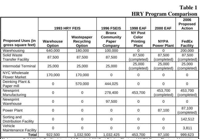
The proposed modification to the development program and project build year would not alter the conclusions for the environmental areas examined in the FEIS and FSEIS. The currently proposed FedEx distribution facility is in keeping with the goals of the original and amended HRY Land Use Plans, and would fit well with the industrial purposes intended for the HRY. Table 1, “HRY Program Comparison,” presents the program components analyzed in the previous environmental assessments as well as the components of the proposed action.
The proposed FedEx sorting and distribution facility (along with the previously approved and constructed New York Post printing plant and NYPA power plant) would replace the paper recycling and deinking facility that was analyzed as part of the 1993 FEIS and 1996 FSEIS and approved as part of the HRY Land Use Plan.
Table 1
HRY Program Comparison
1993 HRY FEIS 1996 FSEIS 1998 EAF 2000 EAF2006 Proposed
Action
Proposed Uses (in
gross square feet) Warehouse Option
Wastepaper Recycling Option Bronx Community Paper Company NY Post Color Printing Plant NYPA Power Plant FedEx Facility Warehousing 640,000 180,000 100,000 0 0 200,000 Solid Waste Transfer Facility 87,500 87,500 87,500 87,500 (completed) 87,500 (completed) 87,500 (completed) Intermodal Terminal 25,000 25,000 25,000 25,000 (completed) 25,000 (completed) 25,000 (completed) NYC Wholesale Flower Market 170,000 170,000 0 0 0 0
Deinking Plant &
Paper mill 0 570,000 444,025 0 0 0 Newsprint Manufacturing 0 0 278,400 453,700 453,700 (completed) 453,700 (completed) Newsprint Warehouse 0 0 97,500 0 0 0 Power Plant 0 0 0 0 87,100 87,100 (completed) Sorting and Distribution Facility 0 0 0 0 0 142,512 Vehicle Maintenance Facility 0 0 0 0 0 3,811 Total 922,500 1,032,500 1,032,425 453,700 87,100 999,623
Notes: Solid Waste Facility, Intermodal Terminal, NY Post Printing Plant, and NYPA Power Plant would remain active uses under the proposed action. Square footage for NYPA Power Plant is approximate.
The proposed action’s potential environmental effects are considered in the following sections for the relevant environmental areas set forth in the CEQR technical manual. These effects are considered in comparison to the previous environmental analyses conducted for the HRY—the 1993 FEIS, 1996 FSEIS, 1998 EAF, and 2000 EAF—to determine whether the proposed action has the potential to result in new significant adverse impacts not identified in those documents.
LAND USE, ZONING, AND PUBLIC POLICY
To determine the proposed action’s potential effects in terms of land use, zoning, and public policy, existing conditions and anticipated future conditions were considered for a study area consisting of a quarter-mile radius from the project site. (See Figure 3) The study area’s southern limit is the Bronx Kill, which serves as a natural boundary.
LAND USE
Since the completion of the 1996 FSEIS, two changes have occurred on parcels that are not part of the current project, but were included in the FSEIS project site. At the easternmost portion of the HRY site, the New York Post color printing plant has been constructed and is currently operational. This development was not considered in either the 1993 FEIS or the 1996 FSEIS, but was the subject of its own EAF in 1998. In 2001, the New York Power Authority constructed a 79.9 megawatt power plant on a two-acre parcel located between the current project site and the Little Hell Gate Bridge. Both of these changes in use were incorporated into the NYSDOT Land Use Plan and are compatible with the industrial use of the Yard.
E A S T R I V E R E.132ND ST. E. 135TH ST . E. 133RD ST. I-87 E. 134TH ST . . LOCUST AVE. WALNUT AVE. WILLOW AVE. ST ANN'S BRUCKNER BL CYPRESS AVE. CYPRESS AVE. TRIBOROUGH BRIDGE N
Project Site Boundary Study Area Boundary (1/4-Mile Perimeter)
SCALE
0 500 FEET
Residential
Residential (with Ground-Floor Retail) Commercial
Industrial, Utilities, Transportation, Public Parking Open Space
Vacant Parcels Vacant Building
Land uses in the parts of the project study area outside of the Harlem River Yard have remained substantially unchanged since 1996. The blocks to the north of the HRY are still primarily characterized by industrial uses, with some anomalous residential uses on East 133rd and 134th Streets. Most of these residences are buffered from heavy industrial uses by a row of warehouses along East 132nd Street. Figure 3 shows existing land uses in the study area.
Because there have been few new developments, the essential land use patterns within the study area have remained consistent with what was detailed in the FSEIS. In keeping with this trend, no significant changes to land use are anticipated to occur within the study area by the proposed project’s 2007 build year.
Because of its industrial character, the proposed FedEx distribution facility would be similar in terms of land use to the proposals contemplated for the project site in the 1993 FEIS and 1996 FSEIS. It would be compatible with surrounding uses both inside and outside of the HRY, and therefore would not alter the conclusions reached by the prior environmental analyses.
ZONING
The project site’s zoning has remained unchanged since the completion of the FSEIS. Most of the site is in an M3-1 heavy industrial district, with the exception of the portion of the site within 200 feet of the Triborough Bridge, which is in an M2-1 medium industrial district. The proposed action does not contemplate a change in the existing zoning and the proposed project would conform with the site’s M3-1 and M2-1 zoning in terms of both use and bulk.
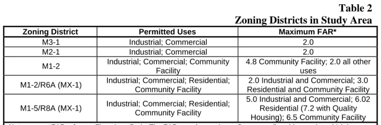
Several blocks of the study area north of the HRY have been rezoned from M1-2 to a Special Mixed Use District since the issuance of the FSEIS. The Port Morris/Bruckner Boulevard Rezoning, adopted by the City Council on March 9, 2005, expanded the existing Port Morris Special Mixed Use District to the east, south, and west. The blocks in the study area west of Willow Avenue between East 133rd and 134th Streets (and between East 132nd and 134th Streets west of Saint Ann’s Avenue just outside of the study area) were included in this rezoning. (See Figure 4.) The Special Mixed Use District allows for residential use and community facilities in addition to the industrial and commercial uses permitted by the underlying manufacturing zoning. (See table 2, “Zoning Districts in Study Area.”) Prior to the rezoning, the affected blocks in the study area were fully built out with a preponderance of non-conforming residential uses. The rezoning action brings these uses into conformance with the Zoning Resolution, and should not be expected to lead to significant changes in land use within the study area.
The proposed project would be built in conformance with the project site’s current zoning. Furthermore, the proposed project would be compatible with the zoning districts currently in the study area. It is not expected that the proposed action would result in any zoning changes in the study area, and it would not alter the conclusions reached in the previous environmental assessments.
Project Site Area Study Area Boundary (1/4-Mile Perimeter)
Zoning District Boundary
Special Purpose District Boundary
E A S T R I V E R N SCALE 0 1000 FEET
Table 2
Zoning Districts in Study Area
Zoning District Permitted Uses Maximum FAR*M3-1 Industrial; Commercial 2.0
M2-1 Industrial; Commercial 2.0
M1-2 Industrial; Commercial; Community Facility
4.8 Community Facility; 2.0 all other uses
M1-2/R6A (MX-1) Industrial; Commercial; Residential; Community Facility
2.0 Industrial and Commercial; 3.0 Residential and Community Facility M1-5/R8A (MX-1) Industrial; Commercial; Residential;
Community Facility
5.0 Industrial and Commercial; 6.02 Residential (7.2 with Quality Housing); 6.5 Community Facility
Note: *FAR refers to Floor Area Ratio. The FAR sets the maximum floor area allowable on a lot, which is determined by multiplying FAR by lot area.
Source: New York City Zoning Resolution
PUBLIC POLICY
Since the completion of the FSEIS, the New Waterfront Revitalization Program (NWRP) was approved by the City Council in October, 1999. This 197-a plan establishes the City’s policies for development and use of the waterfront, and provides the framework for evaluating the consistency of all discretionary actions in the coastal zone with those policies. Under this program, the project site falls within a Significant Maritime and Industrial Area (SMIA). The stated goal for SMIAs is to support water-dependent and industrial uses in New York City coastal areas that are well-suited to their continued operation. Though the proposed FedEx distribution facility is not water-dependent, the waterway in front of the project site is not navigable by barge, and the proposed project would not have an adverse effect on the future development potential of the existing barge basin at the far west end of the HRY. Therefore, the project’s industrial use is consistent with the NWRP. More specific analysis of the proposed project’s compliance with the policies of the NWRP is provided later in this technical memorandum under “Waterfront Policies.”
The Mayor’s Office for Industrial and Manufacturing Businesses has proposed the creation of Industrial Business Zones (IBZ) to help protect and grow New York City’s industrial job base. This policy is likely to be adopted by the proposed project’s 2007 build year. IBZs are areas in which the City will provide business assistance services to active industrial firms, as well as tax credits for industrial businesses that wish to relocate there. In addition, IBZs reflect a commitment by the City not to support the rezoning of industrial land within these areas for residential use. The project site is located within the prospective Port Morris IBZ, and the proposed FedEx distribution facility would fit within the goals of this policy.
Aside from the policies listed above, no additional changes to any public policies have occurred, or are expected to occur, that would affect the proposed project site.
SOCIOECONOMIC CONDITIONS
The proposed project would occupy a currently vacant portion of the HRY, and would not result in the displacement of any residents or businesses.
The proposed FedEx distribution facility would employ up to 326 employees over various shifts. The majority of these employees would be transferred from FedEx’s current facility at 34th
Street in Manhattan. Together with the existing intermodal terminal (69 employees), waste transfer facility (46 employees), NY Post printing plant (approximately 400 employees), and NYPA generating facility (1 employee), businesses in the HRY would be expected to employ approximately 842 workers after the proposed action. This number of jobs is roughly equivalent to the 803 employees estimated for the warehouse option in the 1993 FEIS and the 840 employees estimated for the program analyzed in the 1996 FSEIS.
The proposed distribution facility would increase the storage and distribution of the HRY, and would increase the level of economic activity at the site from today’s vacant condition. The increase in economic activity would be similar to previous proposals, and the proposed action would not alter the conclusions of no significant adverse socioeconomic impacts reached by the previous environmental analyses.
COMMUNITY FACILITIES
As stated above, businesses operating within the HRY would be expected to employ approximately 842 workers with the proposed action. This estimate is similar to the 803 and 840 estimated employees analyzed in the 1993 FEIS and 1996 FSEIS, which determined that sufficient resources and the capacity to accommodate additional demands were present in the community. Therefore, the new employees that would result from the proposed action would not be expected to result in significant negative impacts on local community resources such as schools, libraries, hospitals, and day care centers. The HRY maintains its own security presence, thus allaying demand for police protection. Demand for fire protection services would not be different from what was required by the programs analyzed in the FEIS and FSEIS. Thus, the proposed action would not be expected to result in any significant adverse impacts on local community resources.
VISUAL CHARACTER
As with the previously approved proposals, this development would replace vacant, weed-covered track areas with modern, well-designed industrial facilities. The FEIS and FSEIS, each analyzing the same conditions, both concluded that the introduction of modern industrial buildings would mark an improvement to the visual character of the HRY.
The proposed action would result in the development of two, single story buildings both with an approximate height of about 24 feet. These structures would not be expected to result in any significant adverse visual impacts. The proposed action would not create visual impacts to the north of the HRY, as existing buildings on East 132nd Street and the industrial character of the surrounding area provide a buffer that would screen project site activities from the high-rise residential towers located north of the study area.
No significant adverse impacts are anticipated on views from Randall’s Island because of the current condition and industrial nature of the HRY as well as that of adjacent properties. As concluded in the 1993 FEIS and 1996 FSEIS, the introduction of new industrial structures would be in conformity with the general character of the surrounding industrial district. In addition, the 1993 FEIS noted that a planting buffer would be provided along the waterfront upon completion of the various development components, which would help screen and soften views of the site from much of Randall’s Island.
HISTORIC AND ARCHAEOLOGICAL RESOURCES
As discussed in the 1993 FEIS and 1996 FSEIS, neither the proposed warehouse, waste paper facility, nor Bronx Community Paper Company options would have resulted in any significant adverse effects on historic or archaeological resources.
The proposed FedEx distribution facility would be built over a portion of the footprint analyzed for the BCPC in the 1996 FSEIS. At that time, it was determined that there was no risk of the BCPC’s construction adversely affecting archaeological resources because it would not involve excavation below the layer of fill that covers the HRY. As with the BCPC proposal, construction of the proposed FedEx distribution facility would not involve excavation below this layer of fill, and therefore would not result in any significant adverse effects on archaeological resources. The project site is proximate to the Little Hell Gate Bridge, which is listed in the State and National Registers of Historic Places. Construction of the FedEx distribution facility would not involve any direct alteration to the bridge or its approach. The bridge was built over an active industrial site that could reasonably be expected to change with innovations in industrial technologies, new structures, new industrial uses, etc. The proposed sorting and distribution facility is consistent with the visual context of an industrial area and would be a continuation or updating of the context in which the bridge was built. No other historic resources are located on or near the project site. Thus, development of the proposed FedEx distribution facility would not have any significant adverse effects on historic or archaeological resources.
TRANSPORTATION
See Attachment A, “Traffic and Parking.”
AIR QUALITY
See Attachment B, “Air Quality.”
NOISE
See Attachment C, “Noise.”
INFRASTRUCTURE
Demands for potable water created by the proposed FedEx distribution facility would be less than or similar to those considered for the eastern portion of the HRY in the warehousing option in the 1993 FEIS. Storm sewers and culverts on the project site would be enhanced to provide for adequate drainage of stormwater, and there is sufficient capacity in existing sanitary and storm sewers to accommodate the new flows expected from the proposed facility, as was similarly concluded in the FEIS.
As with the programs considered in previous environmental analyses, commercial waste generated by on-site facilities at the HRY would be handled by private carters. In addition, as required by New York City law, businesses must have arrangements for their recyclables to be collected for recycling, including paper, glass, metals, and plastic.
The proposed project would not result in any significant adverse effects on New York City’s potable water supply, storm and sanitary sewer systems, or solid waste management practices that were not identified in the 1993 FEIS and 1996 FSEIS.
ENERGY
The baseline conditions described in the 1993 FEIS remain accurate and are applicable to the FedEx sorting and distribution warehouse facility. The proposed action would result in increased energy demand for gas and electricity, but cost-effective methods to decrease overall energy demand would be employed by FedEx in the construction of its facility. Therefore, the proposed action is unlikely to result in any significant adverse impacts to energy usage.
WATERFRONT POLICIES
Since the completion of the 1993 FEIS and 1996 FSEIS, New York City has amended its Local Waterfront Revitalization Policy (LWRP). The new LWRP consists of 10 policies designed to maximize the benefits derived from economic development, environmental preservation, and public use of the waterfront, while minimizing the conflicts among those objectives. Each policy is presented below, followed by a discussion of its applicability to the proposed action, and, if applicable, the proposed action’s consistency with the policy.
Policy 1: Support and facilitate commercial and residential development in areas well-suited to
such development.
Policy 1.1: Encourage commercial and residential redevelopment in appropriate coastal zone areas.
The project site is located within the Harlem River Yard, an intermodal rail facility and industrial park. It is zoned for heavy manufacturing uses. Therefore, the site is not appropriate for commercial and residential development, and this policy does not apply.
Policy 1.2: Encourage non-industrial development that enlivens the waterfront and attracts the public.
The HRY and its shoreline are not accessible to the public. Therefore, this policy does not apply.
Policy 1.3: Encourage redevelopment in the coastal area where public facilities and infrastructure are adequate or will be developed.
Public facilities and infrastructure in the area surrounding the project site would be adequate to support the proposed FedEx distribution facility. No undeveloped coastal areas would be affected by the proposed development.
Policy 2: Support water-dependent and industrial uses in New York City coastal areas that are
well-suited to their continued operation.
Policy 2.1: Promote water-dependent and industrial uses in Significant Maritime and Industrial Areas.
The project site, which is located in a Significant Maritime and Industrial Area, would be developed into an industrial distribution and sorting facility. Therefore, the proposed action conforms with this policy.
Policy 2.2: Encourage working waterfront uses at appropriate sites outside the Significant Maritime and Industrial Areas.
The proposed development is located entirely within a Significant Maritime and Industrial Area. Therefore, this policy is not applicable.
Policy 2.3: Provide infrastructure improvements necessary to support working waterfront uses. The project site is physically separated from the waterfront by active railroad tracks. The nearest body of water, the Bronx Kill, is not navigable by barge. Therefore, the project site is not well-suited to support working waterfront uses, and this policy does not apply.
Policy 3: Promote use of New York City’s waterways for commercial and recreational boating
and water-dependent transportation centers.
Policy 3.1: Support and encourage recreational and commercial boating in New York City’s maritime centers.
The Bronx Kill is not one of New York City’s maritime centers and there are no policies or plans for boating along this stretch of waterfront. Therefore, this policy does not apply.
Policy 3.2: Minimize conflicts between recreational, commercial, and ocean-going freight vessels.
The development resulting from the proposed action would not involve recreational, commercial, or ocean-going freight vessels. Therefore, this policy does not apply.
Policy 3.3: Minimize impact of commercial and recreational boating activities on the aquatic environment and surrounding land and water uses.
The proposed action would not be expected to result in commercial or recreational boating activities. Therefore, this policy does not apply.
Policy 4: Protect and restore the quality and function of ecological systems within the New York
City coastal area.
Policy 4.1: Protect and restore the ecological quality and component habitats and resources within the Special Natural Waterfront Areas, Recognized Ecological Complexes and Significant Coastal Fish and Wildlife Habitats.
The development site is not located within a Special Natural Waterfront Area, Recognized Ecological Complex, or Significant Coastal Fish and Wildlife Habitat, nor is there any natural area located on the development site. Therefore, this policy does not apply.
Policy 4.2: Protect and restore tidal and freshwater wetlands.
There are no tidal or freshwater wetlands on the development site. Therefore, this policy does not apply.
Policy 4.3: Protect vulnerable plant, fish, and wildlife species, and rare ecological communities. Design and develop land and water uses to maximize their integration or compatibility with the identified ecological community.
There are no vulnerable plant, fish, and wildlife species, nor rare ecological communities present on the project site. Therefore, this policy does not apply.
Policy 4.4: Maintain and protect living aquatic resources.
The development site is located slightly inland from the Bronx Kill and is separated from the shoreline by railroad tracks. The development that would result from the proposed action would not involve the harvesting of fish, spawning habitat, aquaculture, or fish stocking. Therefore, this policy does not apply.
Policy 5: Protect and improve water quality in the New York City coastal area.
Policy 5.1: Manage direct or indirect discharges to water bodies.
Best management practices would be used to ensure the control of storm water runoff and combined sewer outflows discharging into water bodies during both construction and operation of the proposed facility.
Policy 5.2: Protect the quality of New York City’s waters by managing activities that generate non-point source pollution.
The development program would utilize best management practices to minimize the generation of any nutrients or pollutants or new contributions to non-point source pollution to the Bronx Kill.
Policy 5.3: Protect water quality when excavating or placing fill in navigable waters and in or near marshes, estuaries, tidal marshes or wetlands.
Construction at the development site would require some excavation work. No excavation would occur in navigable waters or in or near marshes, estuaries, tidal marshes, or wetlands, nor would excavation fill be placed in navigable waters or in or near marshes, estuaries, tidal marshes, or wetlands.
Policy 5.4: Protect the quality and quantity of groundwater, streams, and the sources of water for wetlands.
There are no streams or wetlands located on the development site. In the Bronx, groundwater is not used for drinking water or any other purposes. All on-site dewatering, if required, would be conducted in conformance with all applicable regulations.
Policy 6: Minimize the loss of life, structures, and natural resources caused by flooding and
erosion.
Policy 6.1: Minimize losses from flooding and erosion by employing non-structural and structural management measures appropriate to the condition and use of the property to be protected and the surrounding area.
The proposed action would not result in an alteration to the natural features of the shoreline or any structural or non-structural flood or erosion control measures.
Policy 6.2: Direct public funding for flood prevention or erosion control measures to those locations where the investment will yield significant public benefit.
Public funding for flood prevention or erosion control measures is not part of the proposed action. Therefore, this policy does not apply.
Policy 6.3: Protect and preserve non-renewable sources of sand for beach nourishment.
There are no non-renewable sources of sand associated with the development site. Therefore, this policy does not apply.
Policy 7: Minimize environmental degradation from solid waste and hazardous substances.
Policy 7.1: Manage solid waste material, hazardous wastes, toxic pollutants, and substances hazardous to the environment to protect public health, control pollution and prevent degradation of coastal ecosystems.
None of the uses envisioned under the proposed development program would involve the use or discharge of hazardous or toxic pollutants. All contaminated materials uncovered during construction would be handled and removed in accordance the applicable state and federal regulations to prevent impacts on surrounding areas. Solid waste generated during construction and operation of the project would be hauled to out-of-City landfills by a private contractor.
Policy 7.2: Prevent and remediate discharge of petroleum products.
No petroleum products would be expected to be disturbed or discharged as a result of the proposed action. In the unlikely event that petroleum is disturbed or discharged, it would be remediated in conformance with all applicable laws, rules, and regulations, thereby complying with the goals of this policy.
Policy 7.3: Transport solid waste and hazardous substances and site solid and hazardous waste facilities in a manner that minimizes potential degradation of coastal resources.
Solid waste generated by the proposed distribution facility would be hauled by a licensed contractor or waste hauler according to applicable laws and regulations; no hazardous substances would be expected to be generated. The proposed action would not result in a solid or hazardous waste facility.
Policy 8: Provide public access to and along New York City’s coastal waters.
Policy 8.1: Preserve, protect and maintain existing physical, visual, and recreational access to the waterfront.
The HRY is not accessible to the public, and provides no physical, visual or recreational access to the Bronx Kill, East River, or Harlem River waterfronts. Therefore, this policy does not apply.
Policy 8.2: Incorporate public access into new public and private development where compatible with proposed land use and coastal location.
Because of its location within the HRY, the proposed project would not be compatible with the development of public waterfront access. The project site does not extend to the water’s edge; it is separated from the shoreline by railroad tracks and approximately 20 feet of additional ground.
Policy 8.3: Provide visual access to coastal lands, waters, and open space where physically practical.
The nearest publicly accessible thoroughfare to the project site, East 132nd Street, is separated from the Bronx Kill and Harlem River by the HRY. There are no publicly accessible coastal lands or open spaces within the HRY. In the vicinity of the proposed project, the northern portion of the HRY (closest to East 132nd Street) is developed with a row of warehouses and industrial buildings that preclude any possibility of visual access to the Bronx Kill. Therefore, this policy does not apply.
Policy 8.4: Preserve and develop waterfront open space and recreation on publicly owned land at suitable locations.
The project site is located in a Significant Maritime and Industrial Area, and is therefore not considered to be a suitable location for publicly accessible waterfront open space.
Policy 8.5: Preserve the public interest in and use of lands and waters held in public trust by the State and City.
The development site does not contain any lands or waters held in public trust by the State and City.
Policy 9: Protect scenic resources that contribute to the visual quality of the New York City
coastal area.
Policy 9.1: Protect and improve visual quality associated with New York City’s urban context and the historic and working waterfront.
The proposed project is located within a rail yard that houses a variety of industrial uses. The project site, which is currently vacant, would be developed with two industrial buildings and associated parking. Consistent with this policy, the proposed action would be expected to maintain the visual quality currently associated with this urban context.
Policy 9.2: Protect scenic values associated with natural resources.
There are no scenic natural resources located on the project site. Views of the Bronx Kill from East 132nd Street are already obscured by existing warehouse buildings, thus the proposed project would not reduce existing views of this resource. Because the HRY is already industrial in terms of its visual character, the proposed project would not impair the scenic value of the Bronx Kill when viewed from Randall’s Island. Therefore, the development that would result from the proposed action would be consistent with this policy.
Policy 10: Protect, preserve, and enhance resources significant to the historical, archaeological,
and cultural legacy of the New York City coastal area.
Policy 10.1: Retain and preserve designated historic resources and enhance resources significant to the coastal culture of New York City.
As discussed in the “Historic and Archaeological Resources” section, above, the proposed action would not result in any significant adverse effects to any designated historic resources. Therefore, the proposed action is in conformance with this policy.
Policy 10.2: Protect and preserve archaeological resources and artifacts.
As discussed in the “Historic and Archaeological Resources” section, above, the proposed action would not result in an significant adverse impacts to archaeological resources. Therefore, the proposed action is in conformance with this policy.
HAZARDOUS MATERIALS
A limited remediation program to contain contaminants on the project site was presented in the 1993 FEIS and was reviewed by the New York State Department of Environmental Conservation (NYCDEC) and approved by its Hazardous Waste Remediation Bureau. Phase I and Phase II investigations conducted at this time indicated that contamination at the site was primarily due to its past usage as a rail yard and coal storage yard. Based on these investigations, a limited remediation program was approved by NYSDEC that included provisions that the entire site area be covered with controlled fill or topsoil or be paved and that proper engineering controls for dust suppression and personnel protection measures be implemented during construction at the site.
The 1996 FSEIS found that contaminated materials effects associated with the Bronx Community Paper Company were comparable or less than those previously considered in the FEIS, and the approved remediation program still properly addressed the conditions on the site. Construction of the currently proposed FedEx distribution facility would involve a similar degree of ground disturbance as the BCPC would have, but over a smaller area. Therefore, the hazardous materials effects associated with the proposed FedEx distribution facility are comparable or less than those previously considered, and the approved remediation program remains appropriate.
CONSTRUCTION AND CONSTRUCTION IMPACTS
The proposed FedEx distribution facility would occupy a smaller area than the BCPC project analyzed in the 1996 FSEIS and would take about one-year to build. Otherwise, the short-term construction impacts of the FedEx project would be similar to those explained in the FEIS and reiterated in the FSEIS.
The proposed project would have an anticipated construction period of approximately 10 months. Staging for construction activities would take place on-site and would result in minimal disruption to the local community. During construction of the project, worker activities would be governed by a Health and Safety Plan (HASP) to protect potential human exposure to hazardous materials during ground disturbance or dewatering activities. Proper dust suppression controls and personnel protection measures would be implemented during construction at the site to prevent or minimize exposure. As noted in the Hazardous Materials section, once construction has been completed, it is expected that the entire site will be covered with controlled fill or topsoil or be paved to prevent human exposure to hazardous materials. Therefore, no significant adverse construction impacts are expected to occur as a result of the proposed action. Ï
Attachment A: Traffic
and
Parking
A.
INTRODUCTION
This analysis addresses the projected traffic impacts of the proposed FedEx distribution facility at the Harlem River Yard (HRY). The analysis considers the impacts and uses considered in the 1993 Final Environmental Impact Statement (FEIS), as well as subsequent changes in the planned uses. In order to consider present conditions, the traffic analysis: (1) measured actual traffic volumes at key intersections; (2) evaluated the additional impacts projected for the proposed FedEx facility; and also considered the impacts of planned future uses at the HRY, which either have not been implemented or in the case of the solid waste transfer station and the intermodal terminal, that are implemented but are not yet operating at their authorized capacity. Because this analysis is based on a 2006 measured baseline it avoids reliance on the traffic counts that were the basis of the earlier FEIS.
Several studies were previously conducted for potential uses at the HRY, including the Harlem River Yard Intermodal Transportation and Distribution Center FEIS in 1993, the Bronx Community Paper Company Final Supplemental Environmental Impact Statement (FSEIS) in 1996, the New York Post Environmental Assessment Form (EAF) in 1998, and a technical assessment memorandum for the Proposed Modifications to the Solid Waste Transfer Station at the HRY in 2001. The 1993 FEIS provided comprehensive projection of traffic conditions, determination of potential significant adverse traffic impacts, and recommendation of feasible mitigation measures. The subsequent studies concluded that changes in the proposed uses within HRY would fall within the development envelope evaluated as part of the 1993 FEIS.
Although the proposed FedEx distribution facility would be similar in use as those contemplated in these previous studies, the area’s background conditions and traffic analysis methodologies have changed over the years and the specific activities associated with FedEx distribution would result in new auto and truck trips within a portion of HRY that are expected to be greater than those previously assessed. Hence, a detailed analysis was conducted to assess the project’s potential for impacts on traffic and parking conditions in the area. This analysis examines 2006 existing and future 2007 No Build and Build conditions.
As detailed below, the analysis results showed that the proposed project, incorporating some minor project-sponsored improvements, is not expected to result in significant adverse traffic and parking impacts and that a Supplemental EIS to address potential significant adverse impacts associated with the proposed FedEx facility would not be required.
B.
1993 FEIS COMMITMENTS
The 1993 FEIS determined that project-generated activities would result in the potential for significant adverse traffic impacts at three intersections in one or more of the analyzed peak periods. The following measures were proposed to mitigate these impacts. As part of the data
collection efforts conducted for this study, field confirmations were made on whether these measures or variations thereof have been implemented.
• Bruckner Boulevard and St. Ann’s Avenue: Prohibit left turns from Bruckner Boulevard in conjunction with minor signal timing adjustments during the AM and PM peak periods. Field observations indicated that these measures were not implemented at the time updated traffic data were collected.
• Bruckner Boulevard at Lincoln and Alexander Avenues: Restripe Bruckner Boulevard approaches to Lincoln and Alexander Avenues to provide two through lanes and a left-turn pocket in each direction in conjunction with signal timing adjustments at both intersections. Although not proposed as a feasible mitigation measure, the 1993 FEIS indicated that reducing the cycle length at the Alexander Avenue intersection from 120 to 90 seconds would further enhance traffic operations at this intersection. Field observations indicated that these recommendations were not implemented at the time updated traffic data were collected.
• Other Recommended Improvements: It was recommended that the reconstruction of curb returns along East 134th Street at Alexander Avenue, Brown Place, Brook Avenue, and St. Ann’s Avenue would enhance truck turning movements. In addition, roadway repairs along East 132nd Street between Alexander and Cyprus Avenues were necessary to facilitate improved traffic flows. Field observations indicated that the curb return improvements along East 134th Street and roadway resurfacing along East 132nd Street had both been undertaken at the time updated traffic data were collected.
The cumulative traffic for all uses currently contemplated at the HRY has been substantially reduced from the traffic volumes analyzed and found acceptable in the 1993 FEIS. For that reason and based on the current traffic baseline measurements, this analysis concludes that a more limited set of improvements (compared to those incorporated in the 1993 FEIS) should be implemented as part of the future development of the HRY.
C.
EXISTING CONDITIONS
ROADWAY NETWORK
The roadway network in the vicinity of the project site is shown in Figure A-1. This analysis considers six signalized intersections near the project site that are most likely to be affected by project-generated traffic. These intersections, comprising the traffic study area, include Bruckner Boulevard at Lincoln Avenue, the Willis Avenue Bridge, St. Anns Avenue, and East 138th Street; and St. Anns Avenue at East 134th Street and East 135th Street. The physical and operational characteristics of the study area roadways are as follows:
• Bruckner Boulevard is a principal two-way east-west roadway within the study area that functions as a service road to the Bruckner Expressway (Interstate 278/Interstate 95). The service road is striped with two moving lanes in each direction, with certain portions of the roadway—where curbside parking is restricted—operating with three moving lanes.
• St. Anns Avenue is a two-way north-south roadway that provides one effective moving lane and a parking lane in each direction. The roadway, whose southern terminus is located at its intersection with East 132nd Street, is one of the access points to the Harlem River Yard.
NYC R.R. BRIDGE THIRD AVE. BRIDGE WILLIS AVE. BRIDGE E. 138TH ST. E. 137TH ST. ALEXANDER AVE. WILLIS AVE. LINCOLN AVE. THIRD AVE. RIDER AVE. CANAL ST. W . LEXINGT ON AVE. E. 135TH ST. E. 134TH ST. E. 133RD ST. BRUCKNER BLVD. BRUCKNER BL VD. BRUCKNER BL VD. E. 132ND ST. TRIBOROUGH BRIDGE APPROACH ST . ANNS AVE. BROOK AVE. BROWN PL. CYPRESS AVE. FIRST A VE. SECOND AVE. THIRD AVE. E. 124TH ST. E. 125TH ST. PALADINO AVE. E. 126TH ST. E. 129 TH ST. E. 130TH ST. E. 131ST ST. E. 127TH ST. E. 128TH ST.
MAJOR DEEGAN EXPRESSW AY E. 123RD ST. HARLEM RIVER RANDALL'S ISLAND HARLEM RIVER YARD BRONX KILL TRIBOROUGH BRIDGE N SCALE 0 1000 FEET Project Site
• Willis Avenue Bridge is a Bronx bound bridge over the Harlem River. It connects to the northbound Major Deegan Expressway (Interstate 87), the eastbound Bruckner Expressway (Interstate 278/Interstate 95) via Bruckner Boulevard, and other local South Bronx streets. The northbound approach of the Willis Avenue Bridge at Bruckner Boulevard has four moving lanes. Parking is restricted on both sides of this approach.
• Lincoln Avenue is a two-way north-south roadway, whose northern terminus is at its intersection with East 138th Street and southern terminus at its intersection with East 132nd Street. The roadway operates with up to two moving lanes in each direction within the study area. Parking is available on both sides with various restrictions.
• East 134th Street is a one-way eastbound roadway that functions as a service road to the southbound Major Deegan Expressway near the project site. To the east, the roadway is bisected by the Bruckner Expressway and the Triborough Bridge Approach. To the west, it terminates at the Manhattan bound Third Avenue Bridge. East 134th Street provides up to two effective moving lanes and parking is permitted on both sides with various restrictions.
• East 135th Street is a one-way westbound roadway that functions as a service road to the northbound Major Deegan Expressway throughout the study area. To the east, the roadway is also bisected by the Bruckner Expressway and the Triborough Bridge Approach. To the west, it connects with the Manhattan bound Third Avenue Bridge and continues to Park Avenue. East 135th Street provides three effective moving lanes and parking is permitted on both sides with various restrictions.
• East 138th Street is two-way east/west street with one effective moving lane in each direction and a parking lane along both sides of the road. The roadway operates between the East and Harlem Rivers offering connections to the Major Deegan and Bruckner Expressways, as well as Manhattan via the Madison Avenue Bridge.
INTERSECTION CAPACITY ANALYSIS METHODOLOGIES
Operational analyses, following procedures set forth in the 2000 Highway Capacity Manual
(HCM), were conducted for the six signalized intersections within the study area. The analysis methodologies used for analyzing these intersections are described below.
SIGNALIZED INTERSECTIONS
The operational characterization of a signalized intersection relates to the level of service (LOS) of individual lane groups and approaches, and the overall intersection. The determination of LOS is based on the average delay per vehicle at the intersection approach, which is influenced by traffic levels, movement distribution, peaking characteristics, geometric features, and operational parameters. The delay criteria for the range of service levels for signalized intersections are shown in the table below.
Although the HCM analysis methodology also provides a calculation of the volume-to-capacity (v/c) ratio, there is no strict relationship between v/c ratios and LOS. A high v/c ratio indicates substantial traffic passing through an intersection, but a high v/c ratio combined with low average delay actually represents the most ideal operating conditions, under which an approach or the overall intersection processes traffic close to its theoretical maximum capacity with minimal delay. However, very high v/c ratios—especially those approaching 1.0—are often
LOS Criteria for Signalized Intersections
LOS Average Delay
A ≤ 10.0 seconds B > 10.0 and ≤ 20.0 seconds C > 20.0 and ≤ 35.0 seconds D > 35.0 and ≤ 55.0 seconds E > 55.0 and ≤ 80.0 seconds F > 80.0 seconds
Transportation Research Board. Highway Capacity Manual, 2000.
correlated with a deteriorated LOS. LOS A and B indicate good operating conditions with minimal delay. At LOS C, the number of vehicles stopping is higher, but congestion is still fairly light. LOS D describes a condition where congestion levels are more noticeable and individual cycle failures (a condition where motorists may have to wait for more than one green phase to clear the intersection) can occur. Conditions at LOS E and F reflect poor service levels, and cycle breakdowns are frequent. The HCM methodology provides a summary of the total intersection operating conditions. The analysis selects the two critical movements (the worst-case from each roadway) and calculates a summary critical v/c ratio, delay, and LOS.
TRAFFIC CONDITIONS
Existing traffic volumes in the study area were established based on field counts conducted from 7:00 to 9:00 AM and 4:00 to 6:00 PM on January 24, 2006, at the study area intersections. In addition to the manual counts, Automatic Traffic Recorder (ATR) counts were also performed to identify daily variations over a 7-day period. Field inventories of roadway geometry, traffic control, bus stop locations, and parking regulations/activities were recorded and official signal timing data was obtained from the New York City Department of Transportation (NYCDOT) to provide the appropriate inputs for the operational analyses. The traffic count data were used to determine the baseline traffic networks, including the peak hours of traffic activity in the study area. The baseline traffic volumes for the study area intersections were determined to take place from 7:45 to 8:45 AM and 5 to 6 PM, for the weekday morning and evening peak hours, respectively. Figures A-2 and A-3 show the baseline traffic volumes for the weekday AM and PM peak hours.
Within the study area, the maximum existing two-way traffic volumes on Bruckner Boulevard are approximately 3,160 and 3,360 vehicles per hour (vph) during the AM and PM peak hours, respectively. Existing two-way traffic volumes on St. Anns Avenue are between 190 and 505 vph during both the AM and PM peak hours. East 134th Street carries existing two-way traffic volumes between 210 and 415 vph during both the AM and PM peak hours. East 135th Street maximum traffic volumes are approximately 280 and 345 vph during the AM and PM peak hours, respectively. East 138th Street serves between 450 and 585 vph during both the AM and PM peak hours. Lincoln Avenue volumes are approximately 215 vph during the AM peak hour and 275 vph during the PM peak hour. The Willis Avenue Bridge during the AM and PM peak hours serves approximately 1,375 and 1,730 vph, respectively.
WILLIS AVE. BRIDGE E. 138TH ST. E. 137TH ST. ALEXANDER AVE. WILLIS AVE. LINCOLN AVE. THIRD AVE. RIDER AVE. E. 135TH ST. E. 134TH ST. E. 133RD ST. BRUCKNER BLVD. HARLEM RIVER YARD TRIBOROUGH BRIDGE BRUCKNER BL VD. BRUCKNER BL VD. ST . ANNS AVE. BROOK AVE. BROWN PL. CYPRESS AVE. FIRST A VE. SECOND AVE. E. 125TH ST. E. 126TH ST. E. 127TH ST. E. 128TH ST. E. 123RD ST. HARLEM RIVER RANDALL'S ISLAND BRONX KILL E. 132ND ST. TRIBOROUGH BRIDGE APPROACH BRUCKNER BLVD. WILLIS AVE. BRIDGE BRUCKNER BLVD. LINCOLN AVE. BRUCKNER BL VD. BRUCKNER BL VD. E. 135TH ST. E. 134TH ST. BRUCKNER BLVD. ST . ANNS AVE. 90 170 100 80 50 20 160 30 25 670 35 35 1445 5 40 10 125 125 20 30 160 95 20 165 35 90 100 1625 10 5 5 5 1355 20 260 800 30 140 85 85 475 885 60 35 185 50 135 5 5 5 5 90 245 3.13.06 SCALE 0 600 FEET N
WILLIS AVE. BRIDGE E. 138TH ST. E. 137TH ST. ALEXANDER AVE. WILLIS AVE. LINCOLN AVE. THIRD AVE. RIDER AVE. E. 135TH ST. E. 134TH ST. E. 133RD ST. BRUCKNER BL VD. BRUCKNER BL VD. ST . ANNS AVE. BROOK AVE. BROWN PL. CYPRESS AVE. FIRST A VE. SECOND AVE. E. 125TH ST. E. 126TH ST. E. 127TH ST. E. 128TH ST. E. 123RD ST. HARLEM RIVER RANDALL'S ISLAND BRONX KILL BRUCKNER BLVD. E. 132ND ST. RANDALL'S ISLAND HARLEM RIVER YARD TRIBOROUGH BRIDGE APPROACH BRUCKNER BLVD. WILLIS AVE. BRIDGE BRUCKNER BLVD. LINCOLN AVE. BRUCKNER BL VD. BRUCKNER BL VD. E. 135TH ST. E. 134TH ST. BRUCKNER BLVD. ST . ANNS AVE. 45 85 45 65 70 35 200 100 10 660 5 50 1160 25 35 35 120 155 5 55 225 130 45 190 120 105 80 1690 40 5 5 5 1725 5 255 660 25 40 85 55 440 1080 50 45 270 25 40 45 5 5 5 120 155 3.13.06 SCALE 0 600 FEET N
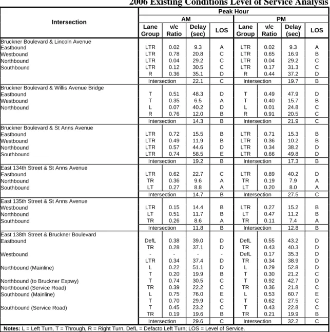
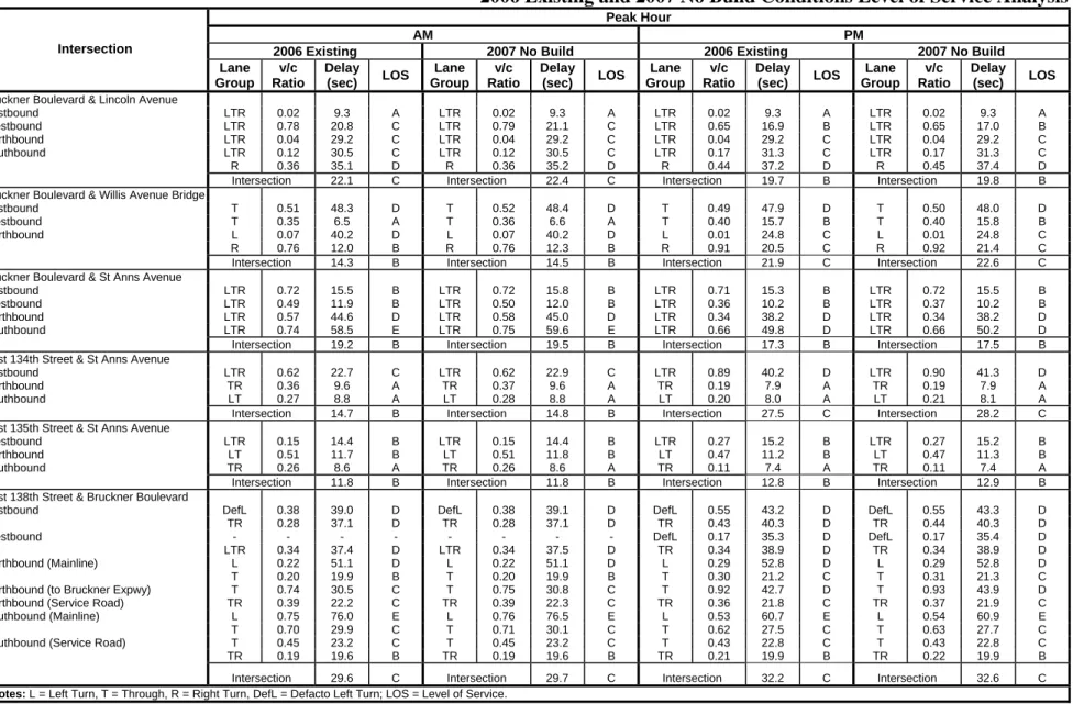
LEVELS OF SERVICE
Table A-1 presents the existing conditions capacity analysis results for the six study area signalized intersections. The capacity analysis indicates that most of the approaches/lane-groups operate at mid-LOS D or better during the AM and PM peak hours, with the exception of:
• The eastbound approach of Bruckner Boulevard at the Willis Avenue Bridge during both the AM and PM peak hours, which operates at LOS D during the AM peak hour, with a v/c ratio of 0.51 and an average delay of 48.3 seconds per vehicle (spv) and during the PM peak hour, operates at LOS D, with a v/c ratio of 0.49 and an average delay of 47.9 spv;
• The southbound approach of St. Anns Avenue at Bruckner Boulevard, which operates at LOS E during the AM peak hour, with a v/c ratio of 0.74 and an average delay of 58.5 spv, and at LOS D during the PM peak hour, with a v/c ratio of 0.66 and an average delay of 49.8 spv;
• The northbound left-turn movement of Bruckner Boulevard at East 138th Street, which operates at LOS D during the AM peak hour, with a v/c ratio of 0.22 and an average delay of 51.1 spv, and at LOS D during the PM peak hour, with a v/c ratio of 0.29 and an average delay of 52.8 spv; and,
• The southbound left-turn movement of Bruckner Boulevard at East 138th Street, which operates at LOS E during the AM peak hour, with a v/c ratio of 0.75 and an average delay of 76.0 spv, and at LOS E during the PM peak hour, with a v/c ratio of 0.53 and an average delay of 60.7 spv.
PARKING
There is on-street parking provided on the majority of the streets within a ¼-mile radius of the project site with various regulations being posted throughout the study area. Based on field observations, parking activity on surrounding streets in the study area is moderate. Since all project-associated parking needs are expected to be accommodated on-site, a quantitative analysis of on-street parking utilization was not conducted.
D.
FUTURE WITHOUT THE PROPOSED PROJECT
Future 2007 conditions without the proposed project (No Build conditions) were forecasted by increasing baseline traffic levels to reflect expected growth in overall travel through and within the study area. As per CEQR guidelines, a background growth rate of 0.5 percent per year was used. Since the counts were taken in early 2006 and the facility is expected to be in full operation sometime in 2007, an overall growth rate of 1.0 percent (0.5 percent per year over a two year period) was conservatively assumed. Other projects expected to be completed in or near the study area by 2007 are discussed in detail below.
RANDALLS ISLAND AQUATIC ENTERTAINMENT CENTER
The Randalls Island Aquatic Entertainment Center would be constructed on a 26-acre site located on the northwestern portion of Randalls Island. Randalls Island, an island located in the East River just south of the project site, currently contains 400 acres of active and passive recreational areas maintained by the Randall’s Island Sports Foundation and the New York City Department of Parks and Recreation. The major component of this project—an outdoor water
Table A-1
2006 Existing Conditions Level of Service Analysis
Peak Hour AM PM Intersection Lane Group v/c Ratio Delay (sec) LOS Lane Group v/c Ratio Delay (sec) LOS Bruckner Boulevard & Lincoln Avenue
Eastbound LTR 0.02 9.3 A LTR 0.02 9.3 A Westbound LTR 0.78 20.8 C LTR 0.65 16.9 B Northbound LTR 0.04 29.2 C LTR 0.04 29.2 C Southbound LTR 0.12 30.5 C LTR 0.17 31.3 C R 0.36 35.1 D R 0.44 37.2 D Intersection 22.1 C Intersection 19.7 B
Bruckner Boulevard & Willis Avenue Bridge
Eastbound T 0.51 48.3 D T 0.49 47.9 D
Westbound T 0.35 6.5 A T 0.40 15.7 B
Northbound L 0.07 40.2 D L 0.01 24.8 C
R 0.76 12.0 B R 0.91 20.5 C
Intersection 14.3 B Intersection 21.9 C
Bruckner Boulevard & St Anns Avenue
Eastbound LTR 0.72 15.5 B LTR 0.71 15.3 B
Westbound LTR 0.49 11.9 B LTR 0.36 10.2 B
Northbound LTR 0.57 44.6 D LTR 0.34 38.2 D
Southbound LTR 0.74 58.5 E LTR 0.66 49.8 D
Intersection 19.2 B Intersection 17.3 B
East 134th Street & St Anns Avenue
Eastbound LTR 0.62 22.7 C LTR 0.89 40.2 D
Northbound TR 0.36 9.6 A TR 0.19 7.9 A
Southbound LT 0.27 8.8 A LT 0.20 8.0 A
Intersection 14.7 B Intersection 27.5 C
East 135th Street & St Anns Avenue
Westbound LTR 0.15 14.4 B LTR 0.27 15.2 B
Northbound LT 0.51 11.7 B LT 0.47 11.2 B
Southbound TR 0.26 8.6 A TR 0.11 7.4 A
Intersection 11.8 B Intersection 12.8 B
East 138th Street & Bruckner Boulevard
Eastbound DefL 0.38 39.0 D DefL 0.55 43.2 D
TR 0.28 37.1 D TR 0.43 40.3 D
Westbound - - - - DefL 0.17 35.3 D
LTR 0.34 37.4 D TR 0.34 38.9 D
Northbound (Mainline) L 0.22 51.1 D L 0.29 52.8 D
T 0.20 19.9 B T 0.30 21.2 C
Northbound (to Bruckner Expwy) T 0.74 30.5 C T 0.92 42.7 D Northbound (Service Road) TR 0.39 22.2 C TR 0.36 21.8 C Southbound (Mainline) L 0.75 76.0 E L 0.53 60.7 E
T 0.70 29.9 C T 0.62 27.5 C
Southbound (Service Road) T 0.45 23.2 C T 0.43 22.8 C TR 0.19 19.6 B TR 0.21 19.9 B
Intersection 29.6 C Intersection 32.2 C Notes: L = Left Turn, T = Through, R = Right Turn, DefL = Defacto Left Turn; LOS = Level of Service.
park—would only be operated during the summer months. However, another smaller component of the project—an indoor beach club—would be in operation year-round. The development is expected to attract 1.3 million annual visitors and to be in operation by early 2007. Although the project is expected to generate several thousand daily trips, most are expected to be made primarily on the regional highway network and during time periods that do not coincide with those of the proposed project. Hence, trips associated with the aquatic entertainment center were not incorporated into the 2007 No Build analysis.