Geert Barentsen
1, Rainer Arlt, Detlef Koschny, Prakash Atreya, Joachim Flohrer, Tadeusz
Jopek, André Knöfel, Pavel Koten, Jonathan Mc Aulie, Jürgen Oberst, Juraj Tóth, Jeremie
Vaubaillon, Robert Weryk, Mariusz Wi±niewski and Przemyslaw oªadek
Email:
[email protected]
We propose a standard XML-based le format for storing and transferring reduced data from photographic and video meteor observations and meteoroid orbits and trajectories. The format is the result of discussions within the Virtual Meteor Observatory (VMO) team, which aims to facilitate collaboration in the meteor science community and increase the scientic impact of combined observational data. The proposed format is extensible and allows meteoroid orbits and trajectories to be traced back to the original observing data and algorithms. We provide a description of the structure of the format and give precise denitions for each data eld.
1 Introduction
The Virtual Meteor Observatory (VMO) project aims to facilitate collaboration between different meteor groups, by giving meteor researchers an easy way to query and retrieve data available to the worldwide com-munity. During the first meeting of the VMO team, it was agreed that a first step towards this goal is to spec-ify a standard file format to store and exchange meteor data (Barentsen et al. 2007, Koschny et al. 2009). The format should store data that has been reduced to a form that makes it suitable for scientific use, yet pro-vide sufficient technical details to allow the quality and origin of the observation to be assessed. Such a format would allow existing data archives and software tools to become compatible through single format conversion tools. It would also encourage software to support a standard format and allow observations to be stored in centralized and searchable archives.
The architecture of the VMO was discussed previ-ously and the reader is referred to Koschny et al. (2008) for a description. In this paper, we propose a file format for storing the reduced results from photographic and video-based observations (hereafter collectively referred to as “camera observations”). We also specify how to store meteoroid trajectories and orbits (which may be derived from any observing technique). In a follow-up article in WGN, we will extend the format to visual ob-servations and fireball reports. By then, we will have covered almost all data sections proposed by Koschny et al. (2009), with the exception of observations by for-ward or backfor-ward scatter radio techniques. Formats for forward scatter data are available from Brentjens (2006) and Terrier (2009) and may be incorporated in the future.
The format presented here, “VMO Format 1.0”, is also documented on the website of the International Me-teor Organization1, where it is accompanied by addi-tional examples and validation tools. We recommend
1http://vmo.imo.net/documentation
users to check the website for updates.
2 File structure
The VMO file format is based on XML, which is a stan-dard method for storing complex information in simple text files. An XML file is a hierarchical structure of ele-ments, which are strings of data enclosed by start- and end-tags. For example, a Perseid meteor of magnitude +2.5 seen on 2009 August 12 may be formatted using XML as follows: <meteor> <time>2009-08-12T00:04:13.25</time> <shower_code>PER</shower_code> <mag>2.5</mag> </meteor>
An example of a well-known XML-based format is XHTML, which is used to define the layout of webpages using elements such as <title> and <img>. In this paper, we describe the VMO format by defining our own suitable elements. These elements must be used according to the XML syntax rules, which are not given here but can easily be retrieved online2.
A file in the VMO format starts with the <vmo> root element, which appears exactly once and encloses the entire contents of the file. The root element must specify the version number (1.0) and the orga-nization that defined the format (IMO) as follows: <vmo version="1.0" xmlns="http://www.imo.net">. The root element may have certain child elements such as <location> (defining an observing site) and
<cam session> (a camera observing session). These
child elements may appear an unlimited number of times in any order. Some of the elements refer to each other, for example a camera observing session refers to an observer and a location as follows:
<vmo version="1.0" xmlns="http://www.imo.net"> <location>
<location_code>DEPOTS</location_code> <name>Potsdam</name>
... </location> <observer> <observer_code>ARLRA</observer_code> <first_name>Rainer</first_name> <last_name>Arlt</last_name> ... </observer> <cam_session> <location_code>DEPOTS</location_code> <observer_code>ARLRA</observer_code> ... </cam_session> </vmo>
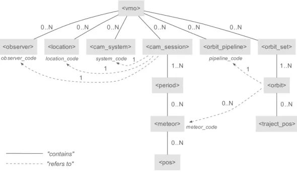
A precise definition of the various elements and their relations is given in Tables 1–13. A graph of the struc-ture is shown in Figure 1, an example file is shown in Figure 2.
Note that we introduce sessions which are comprised of smaller observing periods. Such sessions are not nec-essary for the complete and unambiguous storage of data, but the grouping into sessions makes the handling of data packages far more comfortable. Typical sessions may correspond to nights, but can also correspond to group campaigns or other practical entities. All pho-tographic, video, and later on also visual observations will be grouped in sessions.
The tables and graph show the allowed multiplicity (occurence) of each element. The possible values are “1” if the element is obligatory, “0..1” if the element is optional but should not appear more than once, “0..N” if the element is optional and can appear several times, and “1..N” if the element is obligatory and can appear several times. Elements may appear in any order.
Most elements are intentionally left optional to allow the format to be used even when only minimal data is available. This allows the format to be useful for older data which was created before any standard was defined, or even historical data. However, one should make a reasonable effort to include as many elements as possible.
3 Conventions
In addition to the element definitions given in the ta-bles, a VMO file must adhere to the following conven-tions:
1. The number of digits used to store a number must always be at least 1 or 2 larger than would be called for by the “significant-figures rule”. For example, if an eccentricity was determined to be 0.3266, but with an uncertainty of 0.0021, one should retain the precision ofe= 0.3266±0.0021 and not round to e = 0.327 ± 0.002. The “significant-figures rule” shouldnotbe used when storing numbers that may be used in further com-putations, because it introduces rounding errors. 2. Uncertainties must be given as a standard
er-ror (σ) or covariance value. These errors must
be obtained by propagating the uncertainties of the input data (e.g., the meteor astrometry) to the output data (e.g., the orbital elements). This may be done using analytical propagation formu-las or statistical Monte Carlo iterations.
3. All equatorial coordinates must be given in dec-imal degrees (epoch J2000.0). At least 5 dig-its behind the decimal sign must be supplied if arcsecond-precision is available.
4. All times must be given in Coordinated Universal Time (UTC). This is the international standard on which civil time is based, with leap seconds added at irregular intervals. Times must be for-matted using the ISO 8601 standard (e.g., “2009-08-12T23:14:05”).
4 Traceability
During discussions on the VMO format, several meteor scientists emphasized the importance of being able to trace reduced data back to the original observations and processing steps (Koschny et al. 2007). For example, it should be possible to retrieve the original single-station data that was used to compute an orbit. It should also be possible to determine which algorithms and process-ing steps were used in the computations. The VMO format allows such traceability in the following ways:
1. Orbits and trajectories may be linked to the original single-station data by means of a
<meteor code> element (cf. Figure 1). These
unique meteor codes may be assigned using the rules given in Table 7.
2. Orbits refer to an<orbit pipeline>element (cf. Table 9), which holds references and descriptions of the various processing steps and algorithms used in the determination of the trajectory and orbit. In addition, the state vector of the meteor can be stored to allow the orbit to be recomputed easily.
3. The format provides a <file> element (cf. Ta-ble 13), which allows raw and intermediate data to be linked to the reduced data. For example, we may link an original video clip to a meteor as follows:
<vmo version="1.0" xmlns="http://www.imo.net"> ... <meteor> <shower_code>PER</shower_code> <mag>2.5</mag> <file> <path>videos/met293.avi</path> <comments> Meteor of 2009 Aug 12, 23:14:05 </comments> </file> </meteor> ... </vmo>
Figure 1: Structure of the most important elements in the VMO format. Solid lines denote an element containing another element, dashed arrows denote an element referring to another element through a unique code. Numbers next to the arrows denote the minimum and maximum multiplicity of the relation. All the elements are defined in detail in Tables 1–13.
<?xml version="1.0" encoding="UTF-8"?>
<!-- VMO Format example for video observation --> <vmo version="1.0" xmlns="http://www.imo.net">
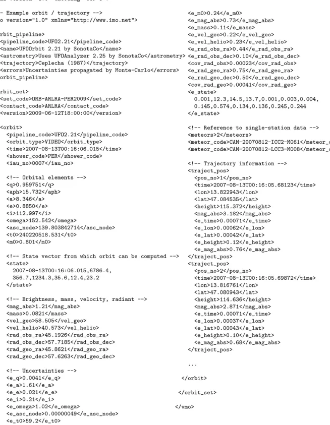
<observer> <observer_code>KOSDE</observer_code> <first_name>Detlef</first_name> <last_name>Koschny</last_name> <city>Noordwijkerhout</city> <country_code>Netherlands</country_code> <email>[email protected]</email> </observer> <location> <location_code>NLNOOR</location_code> <name>Noordwijkerhout</name> <country_code>NL</country_code> <lon>4.491112</lon> <lat>52.265282</lat> <height>55</height> </location> <cam_system> <system_code>TEC1</system_code> <name>TEC1 system, ESA/RSSD</name> <system_type>VIDEO</system_type> <contact_code>KOSDE</contact_code> </cam_system> <cam_session> <system_code>TEC1</system_code> <location_code>NLNOOR</location_code> <observer_code>KOSDE</observer_code> <software_code>METREC_V4.1+</software_code> <camera_code>WATEC</camera_code> <lens_code>FUJ50_1.2</lens_code> <gain>highest setting</gain> <period> <start>2009-01-30T18:04:40</start> <stop>2009-01-31T05:00:00</stop> <teff>10.9175</teff> <meteor> <meteor_code>CAM-20090130-TEC1-M001</meteor_code> <time>2009-01-30T18:17:21.69</time> <shower_code>SPO</shower_code> <speed>14.9</speed> <mag>2.04</mag> <e_mag>0.42</e_mag> <pos> <pos_no>1</pos_no> <time>2009-01-30T18:17:21.69</time> <mag>2.63</mag> <pos_ra>110.91751</pos_ra> <pos_dec>72.38500</pos_dec> <e_mag>0.42</mag> <e_pos_ra>0.0321</e_pos_ra> <e_pos_dec>0.0321</e_pos_dec> </pos> <pos> <pos_no>2</pos_no> <time>2009-01-30T18:17:21.74</time> <mag>2.54</mag> <pos_ra>110.01901</pos_ra> <pos_dec>72.09010</pos_dec> <e_mag>0.42</e_mag> <e_pos_ra>0.0321</e_pos_ra> <e_pos_dec>0.0321</e_pos_dec> </pos> ... </meteor> </period> </cam_session> </vmo>
Figure 2: Example of a video meteor in the VMO format. Note that the right column of this figure needs to be stored below the left column in a real file.
This mechanism allows observing software to use the VMO format as the main output format for the reduced data, while keeping the raw and in-termediate data in the software-specific formats. Data archives may decide whether or not to store this raw data centrally, depending on the avail-able storage and bandwidth resources. There is a <file> option for most of the tables. The
<orbit pipeline> can be accompanied by actual reference papers or even entire software packages using the<file>element.
5 Extending the format
The VMO format is designed to store reduced data, e.g. astrometric and photometric measurements, which are ready to use for scientific analyses. In addition to these parameters, observations produce a lot of raw and intermediate data. We have chosen not to include most of such data, either because it would make the format needlessly complex or because there is no standard way to store the information.
However, the XML syntax provides a mechanism to include additional data in an existing format by means of adding custom elements. Any user may add his own elements by using a namespace prefix in the element names. These elements marked in that way are now out-side the namespace of the VMO, http://www.imo.net. For example, the Polish Fireball Network (PFN) de-cided to include the list of astrometric reference stars in the VMO files. This is achieved by adding a pre-fix, ”pfn”, in front of their custom elements, and the namespace http://pfn.pkim.pl. For example:
<vmo version="1.0" xmlns="http://www.imo.net"> ... <pfn:refstar xmlns:pfn="http://pfn.pkim.org"> <pfn:x>0.2486</pfn:x> <pfn:y>0.3654</pfn:y> <pfn:ra>12.574894</pfn:ra> <pfn:dec>36.542478</pfn:dec> </pfn:refstar> ... </vmo>
It is likely that the extension to store reference star data will be included in the next version of the VMO format, after some additional discussions in the VMO team. Other future extensions may include support for spectra and moving locations (i.e., describing the path of an aircraft). We invite anyone using extensions to join the VMO team and help improve the standard.
We refer the reader to the XML syntax rules for further details on adding custom elements3.
6 Conclusion
We presented the first version of an extensible XML-based file format for reduced data from video- and photographic meteor observations and meteoroid or-bits and trajectories. There is a test site now at
3http://www.w3schools.com/xml/xml namespaces.asp
http://vmotest.imo.net which brings all these tables (and additional auxiliary ones) together in a relational database with some software tools for data ingestion and analysis. These software tools are also available as services to outside users. Data providers will have to provide ingestion routines which convert the data to the VMO format as described in this paper.
We invite the community to evaluate the format and propose corrections and extensions. Meteor researchers are also invited to contribute with actual datasets to let the VMO grow and to discover possible short-comings of the data model described here. Updated versions of the format will be published on the IMO website.
Acknowledgements
We are grateful to Sirko Molau, SonotaCo and Peter Jenniskens for their valuable comments. We thank the International Space Science Institute in Bern for their generous support in this project. Travel expenses for T. Jopek were covered by the Polish Ministry of Science and High Education, grant No. N N203 302 335.
References
[] Barentsen, G., McAuliffe, J., Koschny, D. (2007) “Letter: A Virtual Meteor Observatory”. WGN 35, 71.
[] Brentjens, M. (2006) “Radio meteor data storage in FITS format: METFITS”. Proceedings of the Radio Meteor School 2005 119–128.
[] Koschny, D., Arlt, R., Barentsen, G., Atreya, P., Flohrer, J., Jopek, T., Kn¨ofel, A., Koten, P., L¨uthen, H., Mc Auliffe, J., Oberst, J., T´oth, J., Vaubaillon, J., Weryk, R., Wisniewski, M. (2009) “Report from the ISSI team meeting ‘A Virtual Observatory for meteoroids”’. WGN 37, 21–27.
[] Koschny, D., Mc Auliffe, J., Barentsen, G. (2008) “The IMO Virtual Meteor Observatory (VMO): Ar-chitectural Design”. Earth, Moon, and Planets 102, 247–252.
[] Koschny, D., Mc Auliffe, J., Barentsen, G. (2007) “The Virtual Meteor Observatory (VMO) – A First Definition”.Proceedings of the First Europlanet Workshop on Meteor Orbit Determination 105–122. [] Terrier, P. (2009) “Radio Meteor Observing
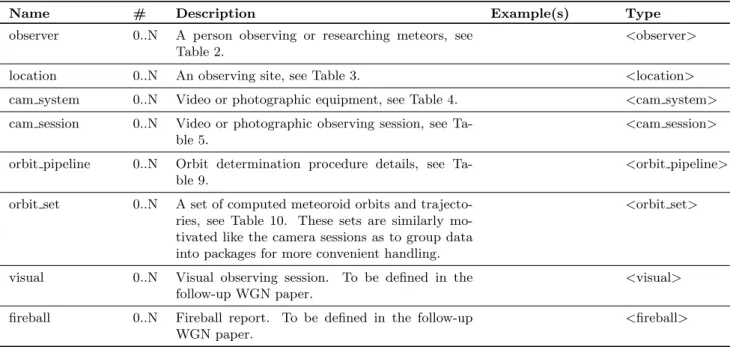
<?xml version="1.0" encoding="UTF-8"?> <!-- Example orbit / trajectory -->
<vmo version="1.0" xmlns="http://www.imo.net"> <orbit_pipeline>
<pipeline_code>UFO2.21</pipeline_code> <name>UFOOrbit 2.21 by SonotaCo</name>
<astrometry>Uses UFOAnalyzer 2.25 by SonotaCo</astrometry> <trajectory>Ceplecha (1987)</trajectory>
<errors>Uncertainties propagated by Monte-Carlo</errors> </orbit_pipeline> <orbit_set> <set_code>ORB-ARLRA-PER2009</set_code> <contact_code>ARLRA</contact_code> <version>2009-06-12T18:00:00</version> <orbit> <pipeline_code>UFO2.21</pipeline_code> <orbit_type>VIDEO</orbit_type> <time>2007-08-13T00:16:06.015</time> <shower_code>PER</shower_code> <iau_no>0007</iau_no> <!-- Orbital elements --> <q>0.959751</q> <aph>15.732</aph> <a>8.346</a> <e>0.8850</e> <i>112.997</i> <omega>152.542</omega> <asc_node>139.803842714</asc_node> <t0>240220518.531</t0> <m0>0.801</m0>
<!-- State vector from which orbit can be computed --> <state>
2007-08-13T00:16:06.015,6786.4, 356.7,1234.3,35.6,12.4,23.2 </state>
<!-- Brightness, mass, velocity, radiant --> <mag_abs>1.21</mag_abs> <mass>0.0821</mass> <vel_geo>58.505</vel_geo> <vel_helio>40.573</vel_helio> <rad_obs_ra>45.1926</rad_obs_ra> <rad_obs_dec>57.7185</rad_obs_dec> <rad_geo_ra>45.8621</rad_geo_ra> <rad_geo_dec>57.6263</rad_geo_dec> <!-- Uncertainties --> <e_q>0.0041</e_q> <e_a>1.61</e_a> <e_e>0.021</e_e> <e_i>0.21</e_i> <e_omega>1.02</e_omega> <e_asc_node>0.00000049</e_asc_node> <e_t0>59.2</e_t0> <e_m0>0.24</e_m0> <e_mag_abs>0.73</e_mag_abs> <e_mass>0.11</e_mass> <e_vel_geo>0.22</e_vel_geo> <e_vel_helio>0.23</e_vel_helio> <e_rad_obs_ra>0.44</e_rad_obs_ra> <e_rad_obs_dec>0.10</e_rad_obs_dec> <cov_rad_obs>0.00023</cov_rad_obs> <e_rad_geo_ra>0.75</e_rad_geo_ra> <e_rad_geo_dec>0.50</e_rad_geo_dec> <cov_rad_geo>0.00041</cov_rad_geo> <e_state> 0.001,12.3,14.5,13.7,0.001,0.003,0.004, 0.145,0.574,0.134,0.136,0.245,0.244 </e_state>
<!-- Reference to single-station data --> <meteors>2</meteors> <meteor_code>CAM-20070812-ICC2-M061</meteor_code> <meteor_code>CAM-20070812-LCC3-M008</meteor_code> <!-- Trajectory information --> <traject_pos> <pos_no>1</pos_no> <time>2007-08-13T00:16:05.68123</time> <lon>13.822943</lon> <lat>47.084535</lat> <height>115.372</height> <mag_abs>3.182</mag_abs> <e_time>0.00071</e_time> <e_lon>0.00062</e_lon> <e_lat>0.00042</e_lat> <e_height>0.12</e_height> <e_mag_abs>0.76</e_mag_abs> </traject_pos> <traject_pos> <pos_no>2</pos_no> <time>2007-08-13T00:16:05.69872</time> <lon>13.816761</lon> <lat>47.080943</lat> <height>114.636</height> <mag_abs>2.871</mag_abs> <e_time>0.00071</e_time> <e_lon>0.00037</e_lon> <e_lat>0.00043</e_lat> <e_height>0.10</e_height> <e_mag_abs>0.68</e_mag_abs> </traject_pos> ... </orbit> </orbit_set> </vmo>
Figure 3: Example of a meteoroid orbit in the VMO format. Note that the right column of this figure needs to be stored below the left column in a real file. The line-breaks and whitespaces inside<state>and<e state>are not allowed, but have been added for readability.
Table 1: <vmo>element: the root element which must appear exactly once in each VMO file and encloses all the data.
Name # Description Example(s) Type
observer 0..N A person observing or researching meteors, see Table 2.
<observer>
location 0..N An observing site, see Table 3. <location>
cam system 0..N Video or photographic equipment, see Table 4. <cam system>
cam session 0..N Video or photographic observing session, see Ta-ble 5.
<cam session>
orbit pipeline 0..N Orbit determination procedure details, see Ta-ble 9.
<orbit pipeline>
orbit set 0..N A set of computed meteoroid orbits and trajecto-ries, see Table 10. These sets are similarly mo-tivated like the camera sessions as to group data into packages for more convenient handling.
<orbit set>
visual 0..N Visual observing session. To be defined in the follow-up WGN paper.
<visual>
fireball 0..N Fireball report. To be defined in the follow-up WGN paper.
<fireball>
Table 2: <observer>element: contact information for a person, such as a visual observer or the operator of a video station. Each observer is uniquely identified by theobserver code, which is used by other elements to refer to an observer.
Name # Description Example(s) Type
observer code 1 Unique alphanumeric identification code for the person, in uppercase. This code has to be unique within each file, and should preferably be reg-istered centrally at http://vmo.imo.net to avoid conflicts.
‘ARLRA’ string
first name 1 Given names and optionally also the middle name. All characters from the extended latin alphabet may be used. For other alphabets, use the English transcription. Avoid nicknames.
‘Rainer’ string
last name 1 Last name(s). Again, only characters from the extended latin alphabet should be used.
‘Arlt’ string
address1 0..1 Address line 1. string
address2 0..1 Address line 2. string
address3 0..1 Address line 3. string
postal code 0..1 Postal code. string
city 0..1 City of residence. ‘Berlin’ string
country code 1 Two-letter ISO 3166 country code of residence. ‘DE’ string
birth year 0..1 Year of birth. Note that this field is optional. ‘1991’ integer
email 0..1 E-mail address. ‘[email protected]’ string
url 0..1 Personal or institute web site. ‘www.rainerarlt.de’ string
affiliation 0..1 Institute, club or association. Enter more than one if needed.
‘AKM’ string
comments 0..1 A comment field allowing free text. string
file 0..N Attach one or more files, for example a photo of the observer. See Table 13.
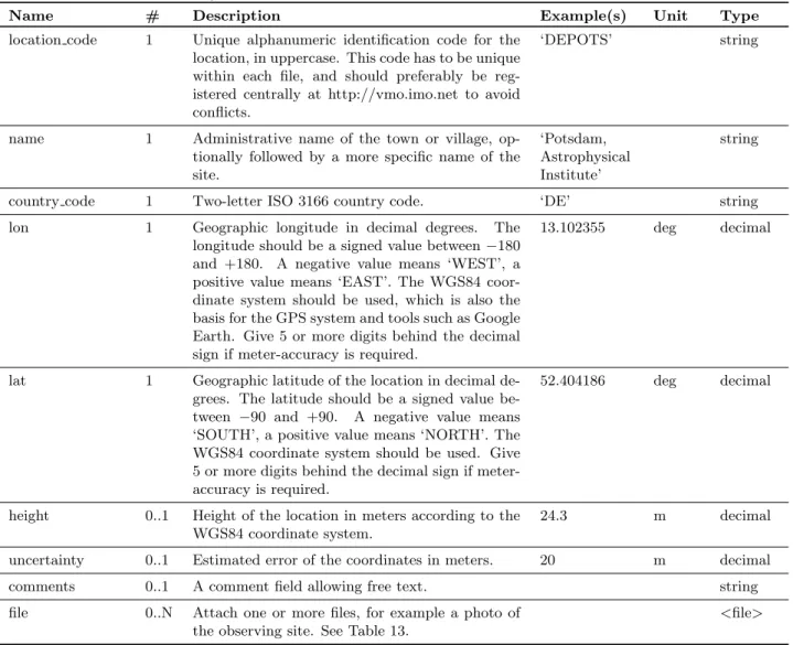
Name # Description Example(s) Unit Type location code 1 Unique alphanumeric identification code for the
location, in uppercase. This code has to be unique within each file, and should preferably be reg-istered centrally at http://vmo.imo.net to avoid conflicts.
‘DEPOTS’ string
name 1 Administrative name of the town or village, op-tionally followed by a more specific name of the site.
‘Potsdam, Astrophysical Institute’
string
country code 1 Two-letter ISO 3166 country code. ‘DE’ string
lon 1 Geographic longitude in decimal degrees. The
longitude should be a signed value between−180 and +180. A negative value means ‘WEST’, a positive value means ‘EAST’. The WGS84 coor-dinate system should be used, which is also the basis for the GPS system and tools such as Google Earth. Give 5 or more digits behind the decimal sign if meter-accuracy is required.
13.102355 deg decimal
lat 1 Geographic latitude of the location in decimal de-grees. The latitude should be a signed value be-tween −90 and +90. A negative value means ‘SOUTH’, a positive value means ‘NORTH’. The WGS84 coordinate system should be used. Give 5 or more digits behind the decimal sign if meter-accuracy is required.
52.404186 deg decimal
height 0..1 Height of the location in meters according to the WGS84 coordinate system.
24.3 m decimal
uncertainty 0..1 Estimated error of the coordinates in meters. 20 m decimal
comments 0..1 A comment field allowing free text. string
file 0..N Attach one or more files, for example a photo of the observing site. See Table 13.
<file>
Table 4: <cam system>element: information on a video or photographic observing system. Each system is uniquely identified by thesystem code, which is used by other elements to refer to a system. The actual technical details of the system have to be given in each <cam session> element, since most components may change frequently and should be specified for each session to ensure correct information.
Name # Description Example(s) Type
system code 1 Unique alphanumeric identification code for the system, in uppercase. This code should preferably be registered centrally at http://vmo.imo.net to avoid conflicts.
‘ICC3’ string
name 1 Long name of the system. ‘ESA/RSSD Intensified
CCD Camera #3’
string system type 0..1 Type of the system. Should be either ‘STILL’
(typically one exposure per meteor) or ‘VIDEO’ (multiple exposures per meteor).
‘VIDEO’ string
contact code 0..1 Contact person for the system, identified by the observer code. The<observer>element for this person should preferably, but not obligatory, be given in the same file.
‘KOSDE’ string
comments 0..1 Free text field for comments. ‘Built in 1998.’ string
file 0..N Attach one or more files, for example system doc-umentation. See Table 13.
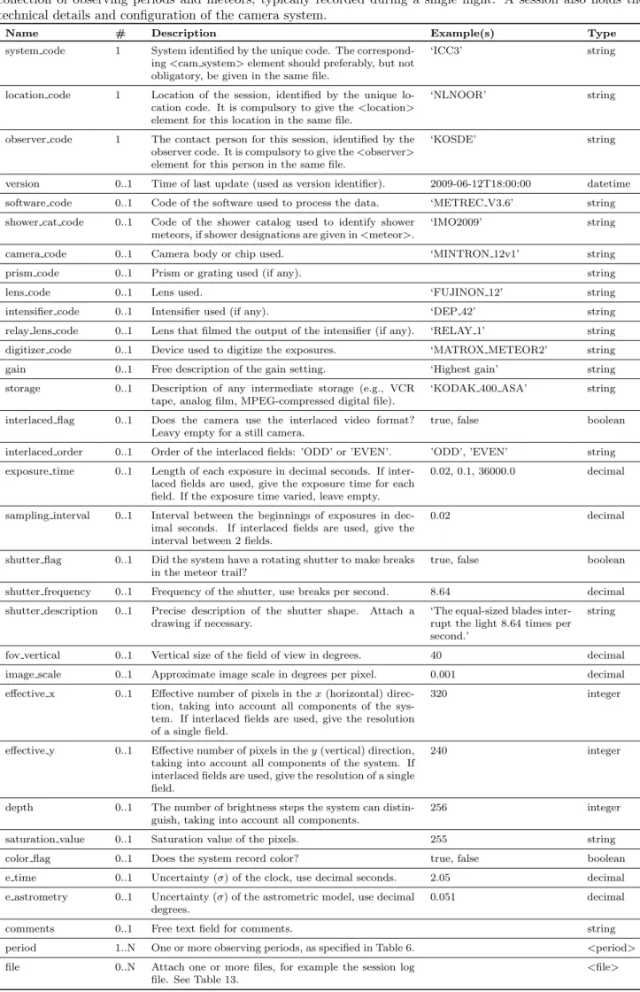
Table 5: <cam session>element: observing session performed using a camera system. A session is an arbitrary collection of observing periods and meteors, typically recorded during a single night. A session also holds the technical details and configuration of the camera system.
Name # Description Example(s) Type
system code 1 System identified by the unique code. The correspond-ing<cam system>element should preferably, but not obligatory, be given in the same file.
‘ICC3’ string
location code 1 Location of the session, identified by the unique lo-cation code. It is compulsory to give the<location> element for this location in the same file.
‘NLNOOR’ string
observer code 1 The contact person for this session, identified by the observer code. It is compulsory to give the<observer> element for this person in the same file.
‘KOSDE’ string
version 0..1 Time of last update (used as version identifier). 2009-06-12T18:00:00 datetime
software code 0..1 Code of the software used to process the data. ‘METREC V3.6’ string
shower cat code 0..1 Code of the shower catalog used to identify shower meteors, if shower designations are given in<meteor>.
‘IMO2009’ string
camera code 0..1 Camera body or chip used. ‘MINTRON 12v1’ string
prism code 0..1 Prism or grating used (if any). string
lens code 0..1 Lens used. ‘FUJINON 12’ string
intensifier code 0..1 Intensifier used (if any). ‘DEP 42’ string
relay lens code 0..1 Lens that filmed the output of the intensifier (if any). ‘RELAY 1’ string
digitizer code 0..1 Device used to digitize the exposures. ‘MATROX METEOR2’ string
gain 0..1 Free description of the gain setting. ‘Highest gain’ string
storage 0..1 Description of any intermediate storage (e.g., VCR
tape, analog film, MPEG-compressed digital file).
‘KODAK 400 ASA’ string
interlaced flag 0..1 Does the camera use the interlaced video format? Leavy empty for a still camera.
true, false boolean
interlaced order 0..1 Order of the interlaced fields: ’ODD’ or ’EVEN’. ’ODD’, ’EVEN’ string
exposure time 0..1 Length of each exposure in decimal seconds. If inter-laced fields are used, give the exposure time for each field. If the exposure time varied, leave empty.
0.02, 0.1, 36000.0 decimal
sampling interval 0..1 Interval between the beginnings of exposures in dec-imal seconds. If interlaced fields are used, give the interval between 2 fields.
0.02 decimal
shutter flag 0..1 Did the system have a rotating shutter to make breaks in the meteor trail?
true, false boolean
shutter frequency 0..1 Frequency of the shutter, use breaks per second. 8.64 decimal
shutter description 0..1 Precise description of the shutter shape. Attach a drawing if necessary.
‘The equal-sized blades inter-rupt the light 8.64 times per second.’
string
fov vertical 0..1 Vertical size of the field of view in degrees. 40 decimal
image scale 0..1 Approximate image scale in degrees per pixel. 0.001 decimal
effective x 0..1 Effective number of pixels in thex(horizontal) direc-tion, taking into account all components of the sys-tem. If interlaced fields are used, give the resolution of a single field.
320 integer
effective y 0..1 Effective number of pixels in they(vertical) direction, taking into account all components of the system. If interlaced fields are used, give the resolution of a single field.
240 integer
depth 0..1 The number of brightness steps the system can
distin-guish, taking into account all components.
256 integer
saturation value 0..1 Saturation value of the pixels. 255 string
color flag 0..1 Does the system record color? true, false boolean
e time 0..1 Uncertainty (σ) of the clock, use decimal seconds. 2.05 decimal
e astrometry 0..1 Uncertainty (σ) of the astrometric model, use decimal degrees.
0.051 decimal
comments 0..1 Free text field for comments. string
period 1..N One or more observing periods, as specified in Table 6. <period>
file 0..N Attach one or more files, for example the session log
file. See Table 13.
Table 6: <period>element: describes the observing conditions and observed meteors in a given interval.
Name # Description Example(s) Unit Type
start 0..1 Time when the observation started. Leave empty if unknown (do not just enter the time of the first meteor). Use the ISO 8601 format in Universal Time (UTC).
2007-08-11T23:46:27 datetime
stop 0..1 Time when the observation ended. Leave empty if unknown (do not just enter the time of the last meteor). Use the ISO 8601 format in Universal Time (UTC).
2007-08-12T00:47:54 datetime
teff 0..1 Effective observing time for activity analysis. Leave empty if unknown.
0.975 h decimal
lm 0..1 Average limiting stellar magnitude during the pe-riod.
6.52 mag decimal
fov alt 0..1 Measured altitude of the center of the field of view above the horizon in the middle of the period.
32.66 deg decimal
fov az 0..1 Measured azimuth of the center of the field of view in the middle of the period. North is 0, east is 90, and so forth.
241.34 deg decimal
fov rotation 0..1 Rotation of the field of view in counter-clockwise direction in the middle of the period. Measured as the angle betweeny-axis and the direction to zenith.
5 deg decimal
fov guided flag 0..1 Is the camera guided, i.e. do the equatorial coordi-nates of the field of view remain constant through-out the period?
true, false boolean
fov obstruction 0..1 Average percentage of the field of view that is ob-structed by clouds, trees, buildings, etc. during the period. This should be a number between 0 and 100.
20.5 % decimal
e teff 0..1 Uncertainty (σ) of teff. 0.050 h decimal
e lm 0..1 Uncertainty (σ) of lm. 0.25 mag decimal
e fov obstruction 0..1 Uncertainty (σ) of fov obstruction. 5.0 % decimal
meteor 0..N Observed meteors, as specified in Table 7. <meteor>
file 0..N Attach one or more files, for example the period log file. See Table 13.
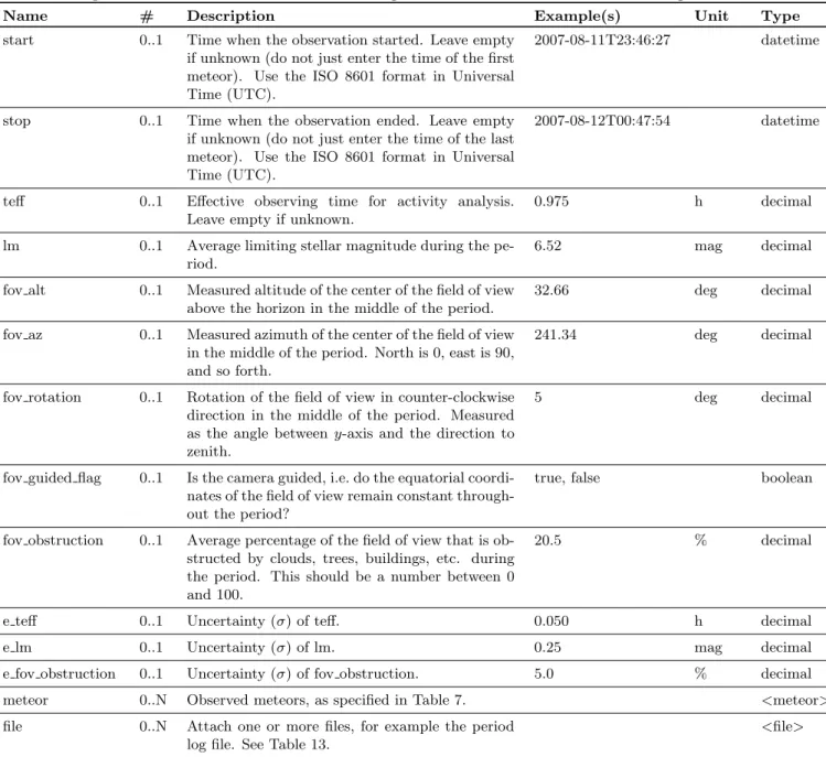
Table 7: <meteor>element: describes a meteor observed by a camera.
Name # Description Example(s) Unit Type
meteor code 0..1 Unique alphanumeric identification code for the meteor. Use the format ‘CAM-YYYYMMDD-SYSTEM-M999’ (all upper-case), whereYYYYMMDDrefers to the date on which the ses-sion started,SYSTEMrefers to the unique code of the cam-era system, and999refers to the relative number of the meteor in the session. For example, the first meteor ob-served by systemICC3in the session that started on 2007 August 11 should be called ‘CAM-20070811-ICC3-M001’. In case a multiple sessions have started on the same date, append ‘-N’ after the date, whereNis the number of the session. For example, the first meteor of the second ses-sion is ‘CAM-20070811-2-ICC3-M001’. In case more than 999 meteors are seen in a session, add extra digits to the meteor number, e.g., ‘CAM-20070811-ICC3-M1000’.
‘CAM-20070811-ICC3-M001’ string
time 0..1 Time when the meteor was first detected. Use the ISO 8601 format in Universal Time (UTC).
2007-08-12T00:12:34.45 datetime
shower code 0..1 The shower designation for the meteor. Initially this is the shower or sporadic source as designated by the observing software, but this value may be recomputed and updated at any point in time afterwards according to an updated standard radiant catalog. ‘SPO’ is also valid.
‘PER’ string
exposures 0..1 Number of exposures in which the meteor was recorded (1 if the observation was photographic).
8 integer
duration 0..1 Duration of the meteor. 1.64 s decimal
mag 0..1 Brightest instrumental magnitude. The magnitude is
“instrumental” because it depends on the spectral re-sponse curve of the camera, which may differ from a visual observer.
3.52 mag decimal
speed 0..1 Average angular speed. 20.30 deg/s decimal
in fov 0..1 Denotes whether the meteor entered or left the field of view. ‘00’ = started and ended outside the field of view, ‘10’ = started inside but ended outside, ‘01’ = started outside but ended inside, ‘11’ = both start and end are inside the field of view.
‘11’ string
begin ra 0..1 Right Ascension (J2000.0) of the begin point. The value may have been corrected, e.g. using a linear fit through the meteor or by manual measurement.
20.8753 deg decimal
begin dec 0..1 Declination (J2000.0) of the above. 45.4875 deg decimal
end ra 0..1 Right Ascension (J2000.0) of the end point. The value may have been corrected, e.g. using a linear fit through the meteor or by manual measurement.
12.8754 deg decimal
end dec 0..1 Declination (J2000.0) of the above. 49.7851 deg decimal
comments 0..1 Free text field for comments. string
e duration 0..1 Uncertainty (σ) of duration. 0.13 s decimal
e mag 0..1 Uncertainty (σ) of mag. 0.21 mag decimal
e speed 0..1 Uncertainty (σ) of speed. 0.54 deg/s decimal
e begin ra 0..1 Uncertainty (σ) of begin ra. 0.0031 deg decimal
e begin dec 0..1 Uncertainty (σ) of begin dec. 0.0025 deg decimal
cov begin 0..1 Covariance of begin ra and begin dec. 0.000035 deg2 decimal
e end ra 0..1 Uncertainty (σ) of end ra. 0.0022 deg decimal
e end dec 0..1 Uncertainty (σ) of end dec. 0.0015 deg decimal
cov end 0..1 Covariance of end ra and end dec. 0.000081 deg2 decimal
pos 0..N Optional instanteneous astrometric or photometric mea-surements, as specified in Table 8.
<pos>
file 0..N Attach one or more files, for example the meteor sum image. See Table 13.
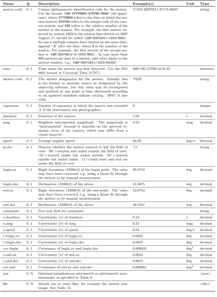
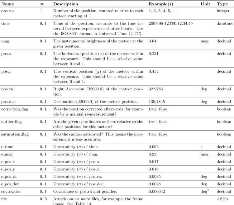
Table 8: <pos>element: describes the astrometric and photometric measurements of a meteor frame.
Name # Description Example(s) Unit Type
pos no 1 Number of the position, counted relative to each meteor starting at 1.
1, 2, 3, 4, 5, . . . integer
time 0..1 Time of the position, accurate to the time in-terval between exposures or shutter breaks. Use the ISO 8601 format in Universal Time (UTC).
2007-08-12T00:12:34.45 datetime
mag 0..1 The instrumental brightness of the meteor at the given position.
3.64 mag decimal
pos x 0..1 The horizontal position (x) of the meteor within the exposure. This should be a relative value between 0 and 1.
0.231 decimal
pos y 0..1 The vertical position (y) of the meteor within the exposure. This should be a relative value between 0 and 1.
0.454 decimal
pos ra 0..1 Right Ascension (J2000.0) of the meteor posi-tion.
32.9785 deg decimal
pos dec 0..1 Declination (J2000.0) of the meteor position. 130.4845 deg decimal
correction flag 0..1 Was the position corrected afterwards, for exam-ple by a manual re-measurement?
true, false boolean
outlier flag 0..1 Are the given coordinates outliers relative to the other positions for this meteor?
true, false boolean
saturation flag 0..1 Was the camera saturated? This means the mea-surement is less accurate.
true, false boolean
e time 0..1 Uncertainty (σ) of time. 0.062 s decimal
e mag 0..1 Uncertainty (σ) of mag. 0.23 mag decimal
e pos x 0..1 Uncertainty (σ) of pos x. 0.017 decimal
e pos y 0..1 Uncertainty (σ) of pos y. 0.018 decimal
e pos ra 0..1 Uncertainty (σ) of pos ra. 0.0035 deg decimal
e pos dec 0..1 Uncertainty (σ) of pos dec. 0.0028 deg decimal
cov ra dec 0..1 Covariance of pos ra and pos dec. 0.000042 deg2 decimal
file 0..N Attach one or more files, for example the frame image. See Table 13.
Table 9: <orbit pipeline> element: describes a pipeline of software and methods used to determine orbits. This is important as meteor scientists prefer to know the exact methods and tools used in the computation of an orbit. Note that the examples shown in this table are kept very short for formatting reasons; in reality one should attempt to give much more details.
Name # Description Example(s) Type
pipeline code 1 Unique code of the orbit determination pipeline. ‘UFO2.21’ string contact code 1 The contact person, identified by the observer
code refering to the <observer>. . .</observer>
element.
‘SONOTACO’ string
name 1 Long name of the pipeline (typically the full name of a software package, including the version num-ber and author name).
‘UFOOrbit 2.21 by Sono-taCo’
string
description 1 General description of the methods and software used to determine the orbit.
‘Uses the UFO
tools available from http://www.sonotaco.com.’
string
astrometry 0..1 Describe how astrometry was obtained from raw images. If astrometry from an existing database was used, note it here. Provide references if pos-sible. Leave empty for radar orbits.
‘Uses UFOAnalyzer 2.25 by SonotaCo. Described in detail in Sonotaco et al (2008), WGN.’
string
trajectory 1 Describe the trajectory determination algorithm. Provide references if possible.
‘Ceplecha (1987).’ string errors 1 Describe how the uncertainties in the astrometry,
trajectory and orbit are estimated.
‘Uncertainties were propa-gated from the astrometry to the orbit using Monte-Carlo (1000 iterations).’
string
mass 0..1 Describe how the mass was computed, and specify if the mass is photometric or dynamical. Provide references if possible.
‘Photometric mass. ReV-elle & Ceplecha (2002), ESA SP-500’
string
comments 0..1 Free text field to provide additional documenta-tion and comments.
‘If this was a real example, there should be much more text!’
string
file 0..N Attach one or more files, for example pipeline doc-umentation or reference papers. See Table 13.
<file>
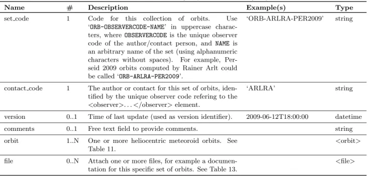
Table 10: <orbit set>element: groups a set of orbits/trajectories.
Name # Description Example(s) Type
set code 1 Code for this collection of orbits. Use
‘ORB-OBSERVERCODE-NAME’ in uppercase
charac-ters, where OBSERVERCODEis the unique observer code of the author/contact person, and NAME is an arbitrary name of the set (using alphanumeric characters without spaces). For example, Per-seid 2009 orbits computed by Rainer Arlt could be called ‘ORB-ARLRA-PER2009’.
‘ORB-ARLRA-PER2009’ string
contact code 1 The author or contact for this set of orbits, iden-tified by the unique observer code refering to the
<observer>. . .</observer>element.
‘ARLRA’ string
version 0..1 Time of last update (used as version identifier). 2009-06-12T18:00:00 datetime
comments 0..1 Free text field to provide comments. string
orbit 1..N One or more heliocentric meteoroid orbits. See Table 11.
<orbit>
file 0..N Attach one or more files, for example a documen-tation for this specific set of orbits. See Table 13.
pipeline code 0..1 Code of the orbit computation pipeline used. A correspond-ing<orbit pipeline>element should be present in the file, describing in detail how the orbit was computed.
‘UFO2.21’ string
orbit type 1 Type of observations used to determine the orbit. Should be either ’VISUAL’, ’STILL’, ’VIDEO’, ’RADAR’ or ’HY-BRID’. If ’STILL’ and ’VIDEO’ data is combined, use ’VIDEO’. For any other combination, use ’HYBRID’ and explain in comments.
‘VIDEO’ string
time 1 Reference time for the meteor; when the meteoroid was at
100 km height. Use the ISO 8601 format in UTC.
1993-04-21T23:20:24 datetime
t0 0..1 Epoch (seconds since J2000.0) for which the orbital elements are given. The epoch is not necessarily the same as the meteor reference time, because the orbital elements may be given for an earlier point in time.
−211248000.3 s decimal
q 0..1 Perihelion distance (small q). 0.9381 AU decimal
a 0..1 Semimajor axis. 6.36 AU decimal
e 0..1 Eccentricity. 0.8537 decimal
i 0..1 Inclination. 80.3717 deg decimal
omega 0..1 Argument of periapsis. 211.3147 deg decimal
asc node 0..1 Ascending node (J2000.0). 31.9439467 deg decimal
m0 0..1 Mean anomaly at epoch t0. 69.4212 deg decimal
shower code 0..1 Code of the meteoroid stream that fits the orbital elements (if any).
‘LYR’ string
iau no 0..1 IAU number of the meteoroid stream that fits the orbital elements (if any).
‘0006’ string
mag abs 0..1 Absolute maximum brightness in the visual spectral range expressed as a magnitude. This is the brightness that would be recorded if the meteor was at a height of 100 km in the zenith of a visual observer.
−3.27 mag decimal
mass 0..1 Meteoroid mass in grams. 1734 g decimal
vel obs 0..1 Observed velocitywithout any correction for atmospheric deceleration, diurnal abberation or zenith attraction.
47.60 km/s decimal
vel inf 0..1 Velocity just before atmospheric entry (= vel obs corrected for atmospheric deceleration and diurnal aberration).
47.70 km/s decimal
vel geo 0..1 Geocentric velocity (= vel inf corrected for zenith attrac-tion).
46.15 km/s decimal
vel helio 0..1 Heliocentric velocity (= vel geo converted to the heliocentric reference frame).
40.32 km/s decimal
height begin 0..1 Height at meteor begin point (leave empty if the begin point was not observed).
103.44 km decimal
height max 0..1 Height at the point of brightest absolute magnitude. 79.23 km decimal
height end 0..1 Height at meteor end point (leave empty if the end point was not observed).
77.02 km decimal
rad obs ra 0..1 Right Ascension (J2000.0) of the observed radiant. This is the radiantwithout any correction for atmospheric deceler-ation, diurnal abberation or zenith attraction.
274.1984 deg decimal
rad obs dec 0..1 Declination (J2000.0) of the above. 33.5586 deg decimal
rad geo ra 0..1 Right Ascension (J2000.0) of the geocentric radiant. This is the radiant corrected for atmospheric deceleration, diurnal abberation and zenith attraction.
274.7741 deg decimal
rad geo dec 0..1 Declination (J2000.0) of the above. 33.2541 deg decimal
z avg 0..1 Average zenith distance of the observed radiant from the different stations.
51.41 deg decimal
conv best 0..1 Best (closest to 90◦) convergence angle. This is the angle between the apparent great circles of meteor motion as seen from any two observing stations; indicating the quality of the observing geometry. Leave empty for radar orbits.
64.5 deg decimal
meteors 0..1 Total number of single-station meteor observations used to compute the orbit.
Table 11: <orbit>element (continued).
Name # Description Example Unit Type
meteor code 0..N Codes of the meteors used to determine the orbit. The corre-sponding<meteor>elements (cf. Table 7) should preferably be given in the same file or be available in a central archive.
string
complete 0..1 Could the meteor trajectory be reconstructed completely from the available data? ‘11’ = yes; ‘01’ = begin is missing; ‘10’ = end is missing; ‘00’ = begin and end are missing.
‘11’ string
state 0..1 7-element state vector (t, x, y, z, vx, vy, vz) of the meteoroid
while producing the meteor;tis the ISO 8601 timestamp in UTC,x, y, zare the Geocentric Equatorial Inertial coordinates relative to epoch J2000.0 (GEI2000), andvx, vy, vzare the
ve-locities in the same reference frame. The state vector should be corrected for atmospheric deceleration and diurnal aberra-tion, but not for zenith attraction. This vector allows for the easy recomputation of orbital elements using different algo-rithms and reference epochs. It is strongly advised to provide this field. 1993-04-21T23:20:24, 6786.4, 3456.7, 1234.3, 35.6, 12.4, 23.2 time, km, km, km, km/s, km/s, km/s vector
e state 0..1 Uncertainty variances and covariances of the state vector. Use the following format: (σ2
t,σ2x,σy2,σ2z,σ2vx,σ
2 vy,σ
2
vz, cov(x, y),
cov(x, z), cov(y, z), cov(vx, vy), cov(vx, vz), cov(vy, vz))
0.001, 12.3, 14.5, 13.7, 0.001, 0.003, 0.004, 0.145, 0.574, 0.134, 0.136, 0.245, 0.244 s2, km2, km2, km2, km2/s2, km2/s2, km2/s2, km2, km2, km2, km2/s2, km2/s2, km2/s2 vector
e time 0..1 Uncertainty (σ) of time. 1.3 s decimal
e t0 0..1 Uncertainty (σ) of t0. 1.3 s decimal
e q 0..1 Uncertainty (σ) of q. 0.0052 AU decimal
e a inv 0..1 Uncertainty (σ) of 1/a. The error of theinverseof the semi-major axis is asked because this quantity follows a normal distribution. The error distribution of the semi-major axis itself is heavily skewed.
1.89 AU decimal
e e 0..1 Uncertainty (σ) of e. 0.040 AU decimal
e i 0..1 Uncertainty (σ) of i. 0.64 deg decimal
e omega 0..1 Uncertainty (σ) of omega. 1.42 deg decimal
e asc node 0..1 Uncertainty (σ) of asc node. 0.000012 deg decimal
e m0 0..1 Uncertainty (σ) of m0. 0.023 deg decimal
e mag abs 0..1 Uncertainty (σ) of mag abs. 0.54 mag decimal
e mass 0..1 Uncertainty (σ) of mass. 102 g decimal
e vel obs 0..1 Uncertainty (σ) of vel obs. 0.58 km/s decimal
e vel inf 0..1 Uncertainty (σ) of vel inf. 0.58 km/s decimal
e vel geo 0..1 Uncertainty (σ) of vel geo. 0.47 km/s decimal
e vel helio 0..1 Uncertainty (σ) of vel helio. 0.42 km/s decimal
e height begin 0..1 Uncertainty (σ) of height begin. 2.33 km decimal
e height max 0..1 Uncertainty (σ) of height max. 1.87 km decimal
e height end 0..1 Uncertainty (σ) of height end. 1.56 km decimal
e rad obs ra 0..1 Uncertainty (σ) of rad obs ra. 0.075 deg decimal
e rad obs dec 0..1 Uncertainty (σ) of rad obs dec. 0.050 deg decimal
cov rad obs 0..1 Covariance of rad obs ra and rad obs dec. 0.00023 deg2 decimal
e rad geo ra 0..1 Uncertainty (σ) of rad geo ra. 0.075 deg decimal
e rad geo dec 0..1 Uncertainty (σ) of rad geo dec. 0.050 deg decimal
cov rad geo 0..1 Covariance of rad geo ra and rad geo dec. 0.00041 deg2 decimal
comments 0..1 Free text field for comments. string
traject pos 0..N Optional instantaneous position along the trajectory of the meteoroid as specified in Table 12
<traject pos>
file 0..N Attach one or more files, for example an orbit graph. See
Table 13.
multiple times inside<orbit>to describe the atmospheric trajectory of a meteoroid in geographic coordinates.
Name # Description Example(s) Unit Type
pos no 1 Number of the point, counted relative to each trajectory starting at 1.
1, 2, 3, 4, 5... integer
time 0..1 Time when the meteoroid was at the given posi-tion. Use the ISO 8601 format in Universal Time (UTC).
2007-08-12T00:12:35.24 datetime
lon 0..1 Geographic longitude in decimal degrees. The longitude should be a signed value between−180 and +180. A negative value means ‘WEST’, a positive value means ‘EAST’. The WGS84 coor-dinate system should be used, which is also the basis for the GPS system.
13.148752 deg decimal
lat 0..1 Geographic latitude in decimal degrees. The lat-itude should be a signed value between−90 and +90. A negative value means ‘SOUTH’, a pos-itive value means ‘NORTH’. The WGS84 coor-dinate system should be used.
52.516435 deg decimal
height 0..1 Geographic height above zero in kilometer, rela-tive to WGS84.
87.1549 km decimal
mag abs 0..1 Absolute brightness in the visual spectral range expressed as a magnitude. This is the brightness that would be recorded if the meteor was in a visual observer’s zenith at a height of 100 km.
−2.4 mag decimal
vel 0..1 Velocity between this and the following
<traject pos>.
46.53 km/s decimal
e time 0..1 Uncertainty (σ) of time. 0.14 s decimal
e lon 0..1 Uncertainty (σ) of lon. 0.00045 deg decimal
e lat 0..1 Uncertainty (σ) of lat. 0.00071 deg decimal
e height 0..1 Uncertainty (σ) of height. 0.0041 km decimal
cov lon lat 0..1 Covariance of lon and lat. 0.00056 deg2 decimal
cov lon height 0..1 Covariance of lon and height. 0.00024 deg·km decimal
cov lat height 0..1 Covariance of lat and height. 0.00083 deg·km decimal
e mag abs 0..1 Uncertainty (σ) of mag abs. 0.42 mag decimal
e vel 0..1 Uncertainty (σ) of vel. 1.3 km/s decimal
Table 13: <file>element: allows files in custom formats to be attached.
Name # Description Example(s) Type
path 1 Location of the file relative to the location of the XML document. Can also be a remote URL.
‘videos/vid287.avi’ string