Archaeology and the Tablet PC
Introduction
The Tablet PC1 is a mobile computer of small dimensions with a screen that you can interact with by using an optical pen, which has digital ink that can be then converted to typed text using software such as Microsoft Word. The Tablet PC was created for use everywhere and under all conditions. Entire professional cat-egories need documents, files, email and electronic agendas. They need to ex-change information and data using portable systems as easily as they use a Per-sonal Computer.
Before the birth of the Tablet PC, the only way to satisfy these requirements was to choose between a PDA and a simple notebook. PDAs of the last gen-eration are small but they do not have the functions of a PC. Notebooks on the other hand are as powerful as desktops, but they cannot be defined as mobile in the true sense of the word. To solve this problem it is possible to use Tablet PCs, which are divided into two categories: slates and convertibles. Slate Tablet PCs have no lid or keyboard and they have the advantage of being particularly light and small sized. Convertible Tablet PCs are notebooks that can be transformed into a tablet by rotating and closing the screen over the keyboard.
The Tablet PC is used with an electromagnetic pen (“digital ink”), similar in shape to the optical pen of the PDA. The technology used by the most of the producers is called “Active Digitizer” and has the following particular characteristic: the layer sensor for the input is behind the LCD screen. Tablet PCs use Windows XP Tablet PC Edition that differs from the classic version of Windows XP because it is able to recognise handwriting and offers the possibility of using digital ink also for Office applications.
Tablet PC and Cultural Heritage
The use of this instrument in the cultural heritage sector is not widespread, how-ever there are some examples where a Tablet PC has had an important role in archaeological studies. Two Italian case-studies are cited: the first one for ar-chaeological research and the second one for didactic and tourist purposes. In both cases, the University of Siena has playeda fundamental role. In the first 1 See the website http://www.tabletpc.it/ dedicated to Tablet PCs. In the section FORUM, it is possible to find various links to websites with software developed for Tablet PC ap-plications.
case the LAP&T Laboratory2 of the University of Siena in Grosseto (Italy) has for many years made use of the archaeological potential of aerial photos work-ing with Tablet PCs (Campana 2005a; 2005b). In fact, it is possible to install the same software used in the laboratory and have access to data directly on the airplane.
This solution offers the mobility necessary to produce a quick and accurate result.. The possibility of connecting a Tablet PC to a GPS Bluetooth helps to localize ar-chaeological anomalies. In fact, it is possible to record the aerial flight routes, the points and the position of all archaeological traces, vertical air photographs, sat-ellite images, data from surveys, published literature and documentary sources, traditional and topographical maps and have them directly on the GIS installed on the Tablet PC.
Another example in which a Tablet PC has been used is called “In&Out”. A Tablet PC, created by the University of Siena and the Agorà ICT Society, was trans-formed into a multimedia tourist guide (Benelli, Todini and Masini 2006). Using the screen of the Tablet PC it is possible to reconstruct the life and the rituals of the Etruscan people, the history and geography of archaeological sites. Given the easy use of the Tablet PC pen, notes can be taken and it is possible to listen to mp3 music and see movies. Using Bluetooth technology, it is possible to listen directly to audio information from earphones. The “In&Out” guide represents a recent example in which new technology offers opportunities for the development of tourism.
Another project, which involved the historical town of Viggiano (PZ – Italy), is still in the working phase. The Tablet PC has been used for the creation of a GIS for the purpose of conducting a census of the Viggiano cultural heritage and in particular of its historical portals (Cianciarulo 2006). Tablet PC will also be used for the creation of a multimedia guide in which to integrate historical information, audio and video.
The experiment in
Grumentum (Grumento Nova – Basilicata – Italy):
The creation of the digital photoplan and the vector drawn on Tablet PC
The experiment3 was conducted in the archaeological site of the Roman town of
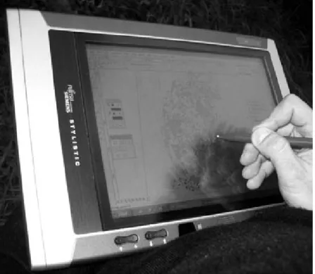
Grumentum (Mastrocinque 2006) in the Basilicata Region – South Italy. The Tab-let PC Fujitsu Siemens Stylistic ST4121 Outdoor 933 with screen TFT 10,4 inches (Fig. 1) was used in Grumentum. The processor is an Intel Pentium III 933 MHz. The hard disk of 60 GB has turned out to be more than sufficient for data saving operations. To enable the Tablet PC to work with numerous softwares contempo-raneously, the computer RAM was increased to 768 MB. Many programs were implemented to make a digital photoplan and use CAD software.
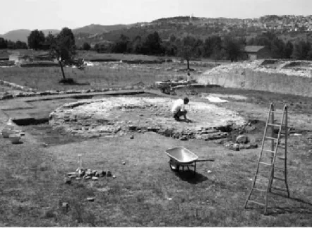
During the last excavation in August 2006, an area was excavated near the Roman
Forum (Fig. 2) and a circular structure was brought to light (Fig. 3). This area of 2 LAP&T Laboratory of Landscape Archaeology and Remote Sensing – University of Siena at Grosseto (Italy), Scientific Direction Dr Stefano Campana (http://www.lapetlab.it/).
Fig. 1 – The Tablet PC used in the Grumentum site.
12m×13m was selected to try this new methodology. After marking off the cir-cumference of the structure, the area was divided into rectangles of 2m×1,5m. At the margins of these rectangles, targetsfixed through a total station were applied. Coordinates were used in order to carry out the next step of photo rectification of the digging surface.
The excavation area was covered by little more than 50 photos taken from a digital camera with a resolution of 3 Megapixel. RDF4 software, written and pro-grammed by Prof. Francesco Guerra5, was used to rectify photos. The digital photoplan obtained (Fig. 4) became the base to be inserted in the Tablet PC. Us-ing a CAD software, such as Vectorworks v.11, the computerization and vectori-alization of the structures and archaeological finds of the area being investigated was carried out.
3Thanks to Prof. A. Mastrocinque – University of Verona (Italy), Scientific Director of Grumentum Project 2005-2007.
4 Free download http://circe.iuav.it/labfot/software/soft_rdf.htm.
5 Scientific director of the Laboratory of Photogrammetry – CIRCE – University IUAV of Venezia (http://circe.iuav.it/).
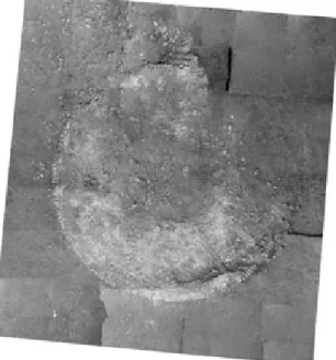
Fig. 3 – The archaeological area excavated during the Summer of 2006. The digital photoplan thus created concerned an area in which many stone frag-ments are present (Fig. 4). The excavation area had been used for drainage dur-ing the excavation and consolidation of the nearby Capitolium. It was possible to execute the vector drawing of stones and structures directly on the screen. This process was quick, and did not require any interruption in the archaeological dig. Manual drawing of a planimetry of a similar area would have demanded time and delayed archaeological work. By dedicating approximately a working day to the surveying phase of the photo targets and to taking photos which will constitute the base for the creation of the digital photoplan, it was possible to document this first phase of excavation quickly and accurately.
The area to be drawn was adapted in order to create a design using Tablet PC. It was not easy to close the polygons created through the CAD software using the digital pen equipment. A traditional mouse was used in addition to the optical pen. With the right hand the drawing was carried out and at the same time with the left hand the designed polygon was closed. In this way, we reduced the number of er-rors that would have been made by only using the optical pen. In fact, given the high sensitivity of the optical pen, there was a high risk of moving or lengthening the trace as it was drawn.
Conclusions
The final result is illustrated in Fig. 5, where the perimeter of the circular structure is shown. In the drawing it is possible to see the smaller circular structure and
Fig. 4 – The digital photoplan (scale 1:10).
towards the angle to the left, the direction of the landslide. Moreover, we have also recorded the areas in which various limestone layers were present connected to the excavated circular structure. An area in the lower part of the drawing is documented in which various mixed fragments of tiles (bricks ??) and stones are visible also from the georadar prospection. The final result is a plan of the excava-tion area on a scale of 1:20 which reveals the structures and the distribuexcava-tion of the stone materials of the landslide with annexed limestone concentrations and tiles (bricks ??) in various points of the excavation. In order to obtain the final result approximately 3 days were necessary.
Considering the level of precision of the digital photoplan the final drawing that was obtained was quite good. The process was fast, reliable and precise. Using instruments like Tablet PC facilitates the phase of surveying and drawing which, during archaeological excavations, are mostly done by hand. In those cases in which plan and section drawings are drawn by hand, they can be quickly digital-ized afterwards in the laboratory with a Tablet PC.
Dario Cianciarulo
Laboratory of Photogrammetry – CIRCE IUAV University of Venezia
References
Benelli, E., Todini, E. and Masini, M. 2006, La guida interattiva IN&OUT. Un modo nuovo di esplorare musei ed aree archeologiche, Archeologia e Calco-latori, 17: 229-240.
Campana, S. 2005a. Tecnologie GPS e personal data assistant applicate all’archeologia dei paesaggi,Archeologia e Calcolatori, 16: 177-197.
Campana, S. 2005b. Applicazioni Tablet PC alla ricognizione aerea. In C. Mus-son, R. Palmer and S. Campana (eds.), In volo nel passato. Aerofotografia e cartografia archeologica, Firenze, All’Insegna del Giglio: 259-260.
Campana, S. and Sordini, M. 2006. Mobile computing in archaeological prospection: an update. In S. Campana, M. Forte (eds.), From Space to Place. Proceedings of 2nd International Conference on Remote Sensing in Archaeology (Roma 2006), BAR International Series 1568, Oxford, Archaeo-press.
Cianciarulo, D. 2004. Applicazioni fotogrammetriche digitali e prospezioni geo-radar nel sito archeologico di Grumentum (Grumento Nova PZ). PhD thesis, Università degli Studi di Pisa, 2003-2004 (http://dareios.altervista.org/, sec-tion CURRICULUM).
Cianciarulo, D. 2006. Il parco musicale di Viggiano: la conservazione di un pat-rimonio culturale tra storia e multimedialità, Informatutti, Suppl. Akiris, XIII, 85: 88-91 (http://www.comuneviggiano.it/informatutti/articoli/17-035-06.pdf).
Cianciarulo, D. 2007. Indagini e proposte per il centro storico di Viggiano (PZ) attraverso l’archeologia dell’architettura. Dall’analisi delle aperture otto-centesche alla conservazione e alla valorizzazione del centro storico, Infor-matutti, Suppl. Akiris, XIII, 36: 24-27.
Mastrocinque, A. 2006. Indagini nell’area del Foro di Grumentum, FOLD&R F astiOnLineDocuments&Research, 69, (http://www.fastionline.org/php/down-load.php?file=FOLDER-it-2006-69.pdf).
Pillon, M. and Sartorelli, L. 2006. L’arena di Grumentum: misura, geometria, forma. PhD thesis, Università IUAV di Venezia – Facoltà di Architettura, 2005-2006.