2007
Gippsland Flood/Storm
Recovery Program
Published by the Victorian Government of Sustainability and Environment & Parks Victoria Melbourne, February 2010
© The State of Victoria Department of Sustainability and Environment & Parks Victoria 2010
This publication is copyright. No part may be reproduced by any process except in accordance with the provisions of the Copyright Act 1968.
Authorised by the Victorian Government, 8 Nicholson Street, East Melbourne. Printed by Stream Solutions
Printed on 100% Recycled paper ISBN 978-1-74242-468-2 (print) ISBN 978-1-74242-469-9 (online)
For more information contact the DSE Customer Service Centre 136 186 or Parks Victoria Information Centre 131 963
Disclaimer
This publication may be of assistance to you but the State of Victoria and its employees do not guarantee that the publication is without flaw of any kind or is wholly appropriate for your particular purposes and therefore disclaims
ENDORSEMENTS
The Gippsland Flood/Storm Recovery Program is a final Report for the Flood/Storm event of June/ July 2007 that followed devastating fires across the Victorian Alps and Gippsland during the Summer of 2006/07. The aim of the Report is to give a final summary of integrated assistance received and achievements completed.
Recovery after the event is about measures that have been taken to achieve desired outcomes by staff, ecosystems and community rebuilding.
The report details
● Visitor Services
● Natural Values, including catchment and River Health
● Indigenous and Post-settlement Heritage, and
● Community and Tourism
The engagement of the community in the plan is seen as paramount to the successful recovery of the affected areas.
The plan recognises that the flood affected area is the ‘Country’ of Gunai-Kurnai, Bidawul, Monero-Nigarigu, Jaimathmathang and Wurundjeri peoples. The Department of Sustainability and Environment (DSE) and Parks Victoria (PV) acknowledge the above indigenous communities as the traditional owners of the affected ‘Country’.
The recovery actions and priorities in the plan are approved for implementation Approved by:
Tony Edgar Chris Rose
EXECUTIVE SUMMARY
In the last week of June 2007, Gippsland received record rainfall associated with an intense low pressure system. The storm followed one of the state’s worst fire seasons, the 2006/07 Great Divide Bushfires, when 1.2 million hectares were burnt and vast areas of soil were exposed. Further compounded by other minor floods in March and November 2007, the storm in June 2007 resulted in major flooding and widespread damage to community and public assets in Gippsland.
In response, the State Government quickly established a Flood Recovery Ministerial Taskforce, which visited Gippsland to assess the flood’s impact and plan the recovery program. From this, the Taskforce outlined a $60 million Flood Recovery Initiative.
This report describes the achievements of the Department of Sustainability and Environment (DSE) and Parks Victoria (PV) in delivering $10 million of this funding, which was the public land component of the program. Another $10 million of the program was allocated to the West Gippsland Catchment Management Authority and the East Gippsland Catchment Management Authority for works focused on stream and water quality, which will be reported separately by these authorities.
Five basins in Gippsland (Latrobe, Thomson, Mitchell, Tambo and Snowy) were affected by the June 2007 flood. All five major rivers within these basins recorded major flood peaks. The flood peaks recorded along the Macalister River, which was the most severely impacted watercourse, were the largest on record.
The major flood event was characterised by the high volume of sediment, woody debris and other material in the flood waters. As this material reached in-stream assets such as stream gauging stations, town water off-takes and bridges, they too were damaged or washed away. More than 40 truck loads of floating debris, including caravans and fridges, were removed from the Glenmaggie Reservoir. Cowwarr Weir also collected a vast amount of material during the event.
Following the floods, community recovery was the highest priority, with efforts directed to restoring normal community functioning as quickly as possible. This was achieved by opening roads and tracks in public land to provide access for local residents, allow through traffic for ongoing commerce and assist the re-establishment of recreation and tourism activities. In addition, community recovery focussed on restoration of Crown Land assets such as public halls, rail trails, camping grounds and public access facilities which are mostly managed by Committees of Management (COMs) on behalf of DSE.
The key outcomes of the Gippsland Flood/Storm Recovery Program were:
● Road and track network re-opened by December, 2008.
● Beaches, jetties and piers repaired, re-established and opened for summer, 2008.
● The re-opening of 80 walking tracks and 108 visitor sites by December, 2008.
● Community halls, rail trails and 33 community projects supported.
● Iconic platypus located and breeding confirmed in four major catchments.
● Gunai/Kurnai participation in cultural heritage surveys.
● The performance of an Indigenous Archaeological Survey on public land.
● Tourism recovery accelerated through rapid public access to public land.
● Local economies supported through restoration of access and short-term employment for Licensed
CONTENTS
ENDORSEMENTS iii
EXECUTiVE SUMMARY iV
1. iNTRODUCTiON 1
1.1 Strategies, Objectives and Scope of the Plan 3
2. PROJECT MANAGEMENT 4
2.1 Governance 4
2.2 Integrated at Place 4
2.3 Progress Reports 5
2.4 Integrated with Bushfire Recovery 5
3. iNSURANCE 7
4. ViSiTOR SERViCES – Outcomes and achievements 8
4.1 Tamboritha Road 10
4.2 Mason Bay Boardwalk (Gippsland Lakes Coastal Park) 12 4.3 Ninety Mile Beach walkovers (Ninety Mile Beach Foreshore Reserve and Gippsland Lakes
Coastal Park) 13
4.4. Sale Common Boardwalk (Sale Common State Game Reserve) 14
4.5 Costin’s Bridge 15
4.6 Cheynes Bridge Recreation Area 16 4.7 Licola Multi-Purpose Community Facility 17
5. NATURAL VALUES – OUTCOMES AND AChiEVEMENTS 18
5.1 Platypus Surveys 19
5.2 Ecological Vegetation Class Studies 20 5.3 Smarter Weed Control 21 5.4. Discovery of a new and emerging weed – The Mexican Poppy 22 5.5 Blackberry Leaf Rust Fungus 23
6. iNDiGENOUS hERiTAGE: OUTCOMES AND AChiEVEMENTS 24
6.1 Reconciliation Week Bus Tours 25 6.2 Archaeological Flood Survey 26
7. COMMUNiTY AND TOURiSM RECOVERY 28
7.1 Community Infrastructure on Crown Land 29 7.2 Community Engagement 30
7.3 Tourism 31
8. REPORTiNG AND REViEw 32
8.1 Learnings 32
1. INTRODUCTION
The Gippsland Flood/Storm Recovery Program concluded on the 30 June, 2008 after more than 400 roads and 80 walking tracks spanning hundreds of kilometres were re-opened, as well as 108 recreation visitor sites on public land affected by the fires and/or flood.
The focus is now on finalising arrangements with Committees of Management, ongoing weed control, and the completion of larger engineering works which were covered by DSE and PV’s insurance policies. An Access Re-opening Strategy was developed on public land which focussed on restoring public access to near pre-flood conditions. Access to all private land has been restored and access to public land has mostly been restored, with most bridges and crossings now re-opened. The exceptions to this are listed in Appendix 3, with completion of works on these roads, bridges and crossings awaiting the processing of insurance claims.
Visitor access to fire and flood-affected public land for recreation and tourism has progressed well. Beachgoers had unrestricted access to Ninety Mile Beach from summer 2007, and removal of destroyed structures, reconstruction of damaged infrastructure and the rapid treatment of inundated toilet blocks has resulted in the rehabilitation of public campsites.
The bare soil exposed by the 2006/07 fires and 2007 floods in Gippsland created ideal conditions for the establishment of weeds. By partnering with the Department of Primary Industries (DPI), Parks Victoria (PV), Catchment Management Authorities (CMAs) and Landcare groups, opportunities to locate, identify and treat new and existing weeds was maximised. In the process, a Landcare officer identified a new weed, the Mexican Poppy, in the Wonnangatta Valley (Section 5.4), which the DSE then eradicated.
Threatened animal and plant species and communities in the flood-affected area were surveyed to assess the degree of damage incurred during the flood event. On-ground survey and monitoring focused on those species considered most at risk. With assistance from the local community, a study on the effect of floods in the Macalister River on platypus was completed. This project provided benchmark data on the platypus population in the Macalister catchment and also an understanding of the capacity of this high level predator to survive flood events.
Indigenous archaeological surveys were completed in areas impacted by the 2006/07 bushfires and subsequent flood events. Due to the difficulty in sourcing suitable contractors to undertake archaeological surveys, the archaeoligical surveys in flood and fire-affected areas were implemented concurrently. The delayed commencement of the field work impacted on the surveys as the vegetation in the fire and flood-affected areas had time to regenerate in the interim, reducing ground surface visibility. Final reports are being compiled and are expected to be completed in June, 2010.
Community engagement focused on raising awareness of the Gippsland Flood/Storm Recovery Program. Bus tours of flood-affected areas held during reconciliation week (September, 2008) were well-attended, talks were given to various community groups including the Maffra Apex Club and the Ben Cruachan walking club. Engagement continues with local tourism operators and four wheel drive clubs and anecdotal advice from the Gippsland tourism industry suggests tourism revenue has returned to pre-fire and flood levels. A brochure to recognise our achievements in the Gippsland Flood/Storm Recovery Program has been published for stakeholders and staff.
Collaboration between DSE, PV, CMAs, DPI, Landcare and local government was critical in the successful delivery of this Gippsland Flood/Storm Recovery Program.
Ongoing project management support was provided post 30 June, 2008, to Committees of Management, to facilitate final project completion.
1.1 STRATEGiES, OBJECTiVES AND SCOPE OF ThE PLAN
The scale and intensity of the Gippsland floods had significant implications for biodiversity, water resources, regional communities, Indigenous and post-settlement cultural values, industry and public infrastructure within the flood-affected areas. The recovery of these values through the Gippsland Flood/ Storm Recovery Program supported the recovery of the region as a whole.
The Gippsland Flood/Storm Recovery Program used four themes to reflect the areas of focus:
● Visitor and recreation facilities;
● Natural values, including catchment and river health;
● Indigenous and post-settlement heritage; and
● Supporting the community and tourism on public pand.
The key objectives of the Gippsland Flood/Storm Recovery Program were:
● to ensure staff and visitor safety, conserve natural and cultural values, and protect water quality;
● to plan and implement all flood recovery activities within approved management directions for
public land, as set out in various park/forest management plans;
● to recognise the rights and aspirations of traditional owners and their primacy to speak for
‘Country’;
● to restore emergency access and where possible enhance risk-mitigation and capacity for future;
● to minimise disruption to public access and the full range of commercial operations and authorised
users that depend on the park/forest;
2. PROJECT MANAGEMENT
The Flood/Storm Recovery Program was managed through a Project Control Board and Implementation Team, which reported to the Executive Director of Land and Fire. The Project Control Board comprised the DSE Regional Directors for Gippsland and North East, and the PV Regional Manager East; with DSE Recovery Manager as Executive Officer. The Implementation team included both project staff and line managers whose responsibility included the affected geographic areas. Team business was focussed around the key themes and supported by policy and technical expertise.
2.1 GOVERNANCE
The Department of Human Services (DHS) is the lead agency for recovery across state and local Government. There are four subcommittees in the DHS’s recovery program: social, economic, built and natural environments. The DSE Recovery Manager led the natural environment subcommittee, which collated data relating to the natural environment, water and agriculture. Data from all subcommittees was collated by DHS and provided the basis for decision making by the Ministerial Taskforce. The DHS established a Gippsland Regional Recovery Committee to coordinate the whole-of-government response; DSE was and continues to be an active participant in this committee. The DHS, DSE and DPI recently provided a joint presentation on the lessons learned from this flood recovery program to the State Emergency Recovery Planning Committee.
In comparison to previous recovery projects, the Flood/Storm Recovery Program provided significantly more support to other DSE portfolio agencies and organisations, particularly Committees of
Management. Through a change in funding arrangements, the DSE was able to provide more direct support to these parties, some of whom previously relied on a grants program administered through DHS. The aim of this more streamlined funding arrangement was to deliver more cost-effective outcomes and to integrate programs across the public land estate.
2.2 iNTEGRATED AT PLACE
The flood impacted on several communities across Gippsland. A number of recovery agencies worked actively to support community recovery in the areas most severely affected by the flood events. It was essential for these agencies to work cooperatively to make sure consistent advice and assistance was provided to those affected. In the past, recovery agencies have been criticised for their disparate response, with each agency contacting and visiting individuals independently, often asking similar questions. Affected individuals became frustrated by this process, which led them to disengage with the agencies, slowing the recovery process. To avoid this situation in the Flood/Storm Recovery Program, a concerted effort was made to form collaborative relationships between Recovery Officers from the various agencies; to facilitate the sharing of information and to gain an understanding of the range of assistance provided by the various agencies.
The high country township of Licola was severely impacted by the Great Divide Fires and the subsequent flood events. Support to the Licola community was initially facilitated through the Shire of Wellington, which assisted local residents in the establishment of the Licola Recovery and Development Committee. This committee was then used as a key point of contact by recovery agencies when seeking information on recovery issues and priorities. The recovery agencies were also able to use this committee to facilitate information on the recovery process into the Licola community.
A multi-agency collaboration developed between the CMA, Landcare, PV, DSE (Forest), DSE (Crown Land) and DPI allowed the pooling of resources, to mount an effective attack on the weed populations that developed after the flood events. Through local Landcare networks, priority weed species and locations were determined, and works involving the other agencies were initiated under a single supervisory and coordination structure. It was through this network that the new ‘weed’ Mexican poppy was located, identified and rapid control actions implemented.
2.3 PROGRESS REPORTS
Progress Reports, for the Project Control Board and Agency Executives, were prepared on a quarterly basis to monitor progress of works and finance, and to report achievements. These reports were also distributed widely to staff and interested stakeholders. Copies of these reports are available on FireWeb.
2.4 iNTEGRATED wiTh BUShFiRE RECOVERY
Several areas impacted on by the 2006/07 bushfires were again damaged by the subsequent Gippsland flood events. Perversely, the loss of vegetation that occurred as a result of the bushfires rendered vast areas vulnerable to erosion in large rainfall events. The resultant flood damage within the burnt areas was noticeably greater than that in surrounding areas, due to the degree of exposed soil.
Recovery agencies had already implemented a number of recovery measures following the bushfires, including establishment of teams to implement bushfire recovery actions, and the engagement and deployment of external resources and contractors. Unfortunately, the floods destroyed some of the bushfire recovery works that had been completed. In bushfire-affected areas that had not yet been recovered, the flooding exacerbated the extent of damage already incurred. For example, the bridge in
With bushfire recovery staff already in place and experienced in the recovery process, it was determined that the most efficient means of resourcing the flood recovery effort was to operate both the fire and flood/storm recovery programs concurrently, using largely the same team. Additional resources were engaged to service those areas unaffected by the bushfires, but impacted by the floods.
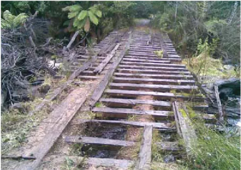
Fig. 1: An example of a bridge that suffered both fire and flood damage.
3. INSURANCE
The DSE and PV each carry separate insurance policies with the State Government’s Victorian Managed Insurance Authority (VMIA). Both organisations had a substantial range of assets damaged by the storm and flood events (see Figure 2); the repair and replacement of which were claimed under their respective policies.
Largely similar, the policies cover the repair or replacement of built assets damaged or destroyed by the storm or flood. The repair of roads, tracks and bridges form the major component of both claims. Damaged assets were assessed by DSE, PV and VMIA staff. Most of the damaged assets have been repaired, however, significant works are still required to re-open several roads and bridges (see Appendix 3). These projects are expected to be completed in the 2009/2010 financial year as the insurance claim concludes.
ORBOST BRIGHT WARBURTON MANSFIELD BAIRNSDALE MARYSVILLE
Fire and Flood Recovery Insured Assets & Infrastructure ~ July 2008
DSE/DPI Use Only
Developed by GIS Unit DSE Gippsland
Disclaimer: This map may be of assistance to you but the State of Victoria and its employees do not guarantee that the publication is without flaw of any kind or is wholly appropriate for your particular purposes and therefore disclaims all liability for any error, loss or other consequence which may arise from you relying on any information in this publication.
Map Grid of Australia 1994 (MGA94) Zone 55 Universal Transverse Mercator (UTM) Projection Geocentric Datum of Australia (GDA)
Imagery Information: Please refer to electronic version of this map for more information about any imagery.
MOE SALE MORWELL WARRAGUL DANDENONG BAIRNSDALE COWES FOSTER YARRAM MAFFRA ORBOST BRIGHT GEMBROOK CORRYONG WARBURTON INVERLOCH WONTHAGGI LEONGATHA STRATFORD MANSFIELD KORUMBURRA MARYSVILLE PAYNESVILLE HEALESVILLE LAKES ENTRANCE 300 400 500 600 700 57 00 000m. N 5700 5800 5800 5900 5900 6000 BA CA CA DA DA EA EA FA FA GA GA 6000 BSCS CSDS DSES ESFS FSGS GS BT BT CT CT CT CT DT DT DT DT ET ET ET ET FT FT FT FT GT GT GT GT BU BU CU CU CU CU DU DU DU DU EU EU EU EU FU FU FU FU GU GU GU GU BV BV CV CV CV CV DV DV DV DV EV EV EV EV FV FV FV FV GV GV GV GV BA CA CA DA DA EA EA FA FA GA GA KB KC KC KD KD KE KE KF KB KC KC KD KD Repaired DSE - Fire DSE - Flood PV - Fire PV - Flood Damaged DSE - Fire DSE - Flood PV - Fire PV - FloodMain Gippsland Towns
Major Roads
Major Rivers
Road Closure Status
Closed Open Wildfires: Season 200607 Land Tenure Park Private Land Other Public Land
048 16
Kilometres 1:750,000 Approximate Scale:
4. VISITOR AND RECREATION SERVICES:
Outcomes and achievements
ALLOCATiON $7.3M
Objectives and Strategies
● Restore visitor access
● Repair or replace visitor facilities, recreational and tourist built assets
Achievements
● The restoration of the road network for accessing public sites e.g. the re-opening of Tamboritha
Road, which provides access to the Alpine National Park, occurred within six months of the major flood event.
● The provision of public access to major visitor sites within months of the major flood event e.g.
public access to Ninety Mile beach was restored by summer 2007.
● Restoration of the walking track network e.g. Blue Pool, Little Cabbage Tree Creek Falls and
Youngs Creek Loop Track were opened within six months of the major flood event.
● Re-opening of public recreation sites e.g. Chenynes Bridge Recreation Area was re-opened by
December, 2008.
The Gippsland flood/storm events rendered a great deal of the public land inaccessible to the public. Tree fall, landslips and erosion severely damaged several roads, walking tracks and camping areas within parks, reserves and State forests in Gippsland. Immediately post-flood, the highest priorities in the recovery process were damage-assessment and the facilitation of local access to private land. Damage assessment was undertaken as soon as it was safe and practical to access impacted areas of public land. The completed asset assessments formed the basis for the identification of insurable works, the re-opening strategy and the prioritisation of recovery works.
The second priority, to facilitate access to private land, concerned the high-country townships of Licola and Glencairn, which were effectively cut-off after the flood washed away and damaged parts of Licola Road, including Cheynes Bridge. VicRoads installed a temporary bridge within six weeks of the June flood event, however, this was washed away in a subsequent flood in November, 2007. The temporary bridge was repaired within four days. A permanent flood-proof bridge was opened in September, 2008, securing access for locals into the future. Springs Road, which provides access to Licola from Seaton, was re-opened by DSE within five months of the major flood event.
Once flood damage assessments were completed and access to private land restored, the focus of the recovery program progressed to the re-opening of roads on public land, which was essential to support the social and economic needs of local communities. A public land Access Re-opening Strategy was developed and released for public comment. Comments received at public sessions at Traralgon and Bairnsdale and through direct contact with individuals and interest groups were used to direct road re-opening priorities. The Access Re-re-opening Strategy, which was published and updated regularly on the Parks Victoria website, informed the sequence of the works programs. Works on the road network in the lower country began soon after the flood waters receded, with roads re-opened in quick succession. Work on the roads and tracks in the alpine areas did not start until after the seasonal road closures were lifted in early November, 2007. Most public land was accessible by December, 2007, however some routes remain restricted due to the need for major repairs (see Appendix 3).
Flood and storm damage to visitor and recreation infrastructure on public land included damage to board walks and pedestrian bridges in recreation sites along the Gippsland Lakes, and the devastation of riverside-camping areas. The first priority of the Gippsland Flood/Storm Recovery Program was to assess the flood damage and identify risks to public safety. After debris and damaged structures were removed and flooded toilets pumped out, plans were made to begin repair works to facilitate public usage of the recreation sites as soon as possible. Much of the damage to visitor infrastructure was covered by insurance, however some works such as debris cleanup, were not. Much of these latter works were performed by seasonal workforce or other temporary staff.
Some of the major tasks and achievements in the visitor services theme are discussed on the following pages.
4.1 TAMBORiThA ROAD
The major flood in June 2007 significantly damaged 22km of the southern-most end of Tamboritha Road (see Figures 3 and 5). Tamboritha Road is the main access route into the Alpine National Park (Wonnangatta – Moroka High Country) and other public land from the west (via Licola), and provides two-wheel drive access to popular campsites along the Wellington River. The first 6km section of Tamboritha Road was constructed by the former Forest Commission, and the authority responsible for the management of this section is currently under review by VicRoads. In the interim, the DSE undertook recovery of this stretch of road. Earlier recovery works as a result of a previous flood were also undertaken by DSE prior to the June 2007 flood. These works costing $200,000, were destroyed in the June flood event.
The remaining 16km of Tamboritha Road is managed by Parks Victoria. Both the 6km section and the 16km section were extensively damaged in the June flood and repair work included the repair of two bridges, the building of a number of substantial retaining walls to prevent the river washing away the road and the reconstruction of several culverts (see Figures 4 and 6).
There was considerable public interest in the re-opening of Tamboritha Road, particularly from Licola residents and business owners. The restoration of the road was a high-priority, however works were hampered by the extent of the damage (see Figures 3 and 5) and the instability of the surrounding countryside. Indeed, two days before Christmas, 2007, a small rain event resulted in the blocking of the repaired track due to rock fall. The road was re-opened for public use in the first week of January 2008 and was only closed temporarily following this to accommodate major repairs.
The partnership between DSE, PV, VicRoads and the VMIA meant that the enormous engineering challenge associated with opening this road could be managed as a single project. The final repair bill for the re-opening of the road was in excess of $6 million.
Fig. 3: The massive rainfall in the Macalister River catchment overwhelmed and destroyed many culverts on the Tamboritha Road.
Fig. 4: The same culvert, near completion.
Fig. 5: Large sections of the Tamboritha Road were washed away completely posing a significant challenge to repair.
Fig. 6: The same section of road repaired using a substantial retaining wall.
4.2 MASON BAY BOARDwALk (GiPPSLAND LAkES COASTAL PARk)
Mason Bay is located on the Banksia Peninsula on the Gippsland Lakes. The peninsula is a low-lying, sandy remnant of an ancient shoreline, surrounded by coastal dunes. The original steps over the dunes were replaced with a boardwalk spanning the water’s edge in May, 2007. The significant wave action and extra water from the flood and storm event in June, 2007, ripped the boardwalk decking off its footings and eroded the adjoining bank (see Figure 7). Parks Victoria installed a retaining wall and repaired the damaged boardwalk with an upgraded design (see Figure 8). The new boardwalk has been secured on to a concrete base, effectively rendering it flood-proof.
Fig. 7: The Mason bay boardwalk was severely damaged by the June flood event
Fig. 8: A new flood-proof boardwalk has been erected at Mason Bay
4.3 NiNETY MiLE BEACh wALkOVERS (NiNETY MiLE BEACh FOREShORE
RESERVE AND GiPPSLAND LAkES COASTAL PARk)
The June storm-surge eroded large sections of the Ninety Mile Beach, destroying many beach access points and effectively preventing public access (see Figure 9). To provide secure access to the most popular sections of the beach, three timber walkovers were constructed. These were located at The Honeysuckles and Paradise Beach (see Figure 10) near Seaspray, and at McLoughlins Beach near Yarram. The timber ‘step and platform’ structures were designed to:
● Minimise the impact on the dune system.
● Withstand harsh storms and extreme king tides.
● Provide safe access to the beach following storm events.
The structures were built with sensitivity to the existing coastal vegetation. The walkovers located at The Honeysuckles, Paradise Beach and McLoughlins Beach, provide the public with easy access to the beach. Community feedback has been very positive; indeed, there have been many requests for the installation of more walkovers along the Ninety Mile coastline.
Fig. 9: The storm-surge caused extensive damage to the dune system at Paradise Beach
Fig 10: The completed dune system at Paradise Beach
4.4 SALE COMMON BOARDwALk (SALE COMMON STATE GAME RESERVE)
Sale Common State Game Reserve is located approximately three kilometres south-east of the Sale township and falls within the Gippsland Plains Bioregion. The reserve is 300 hectares, seventy percent of which is freshwater marsh. The remaining areas are occupied by Red Gum woodland and grasslands. The wetlands at the Common flooded several times during 2007, the last flood event occurring in November. These floods and an algal bloom over late spring 2007, and early summer 2008, delayed the repairs to the Common boardwalk which was severely damaged by the flood (see Figure 11). The boardwalk was repaired with re-enforced footings to prevent damage in future flood events (see Figure 12). Repairs were completed and the boardwalk re-opened by May, 2008.
Fig. 11: The boardwalk at Sale Common was ripped from its footings in the major flood event
Fig. 12: The new boardwalk at Sale Common has re-enforced footings to prevent damage in future events.
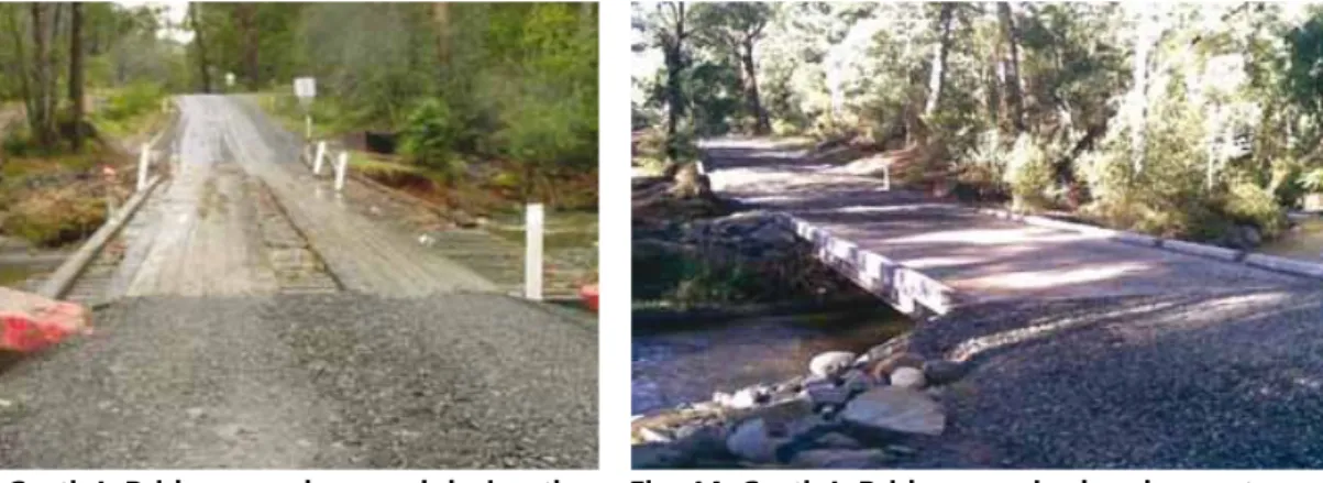
4.5 COSTiN’S BRiDGE
Costin’s Road forms part of an alternative route to access the alpine village, Tanjil Bren. It is also a key timber haulage route and used regularly by the local community. In previous years, Costin’s bridge, which facilitates the traverse of Costin’s Road over the Tanjil River, has undergone a number of repairs to extend its life including: re-decking, restoration of abutments and construction of two props under the bridge surface. Costin’s Bridge was damaged in the June 2007 floods (see Figure 13).
Due to the instability of the bridge following the flood event, Costin’s Road was closed to the public until repair works could be undertaken. A tender was developed for the bridge’s repair and the successful contractor re-constructed the bridge between 1 February and 19 March 2008 (see Figure 14).
Fig. 13: Costin’s Bridge was damaged during the June flood event, causing the closure of Costin’s Road.
Fig. 14: Costin’s Bridge, repaired and open to traffic.
4.6 ChEYNES BRiDGE RECREATiON AREA
Cheynes Bridge Recreation Area, which is a popular camping and picnic area, is adjacent to Licola Road, 35 kilometres north of Heyfield. The area sustained significant damage during the 2006/2007 Great Divide Fires and the subsequent Gippsland flood and storm events (see Figure 15). After the flood in November, 2007, the site was closed to the public for two months to allow re-vegetation and re-development works to be undertaken. The DSE worked in partnership with local Landcare and Lions groups, the Sale-Maffra Motorcycle Club, the Fulham Correctional Centre and the West Gippsland Catchment Management Authority (WGCMA) to re-develop the recreation site (see Figure 16). Works undertaken at the site included fencing and planting of the river bank to promote re-vegetation, installation of toilets, signage, picnic tables, fire pits and a new trail bike unloading area.
Fig. 15: Cheynes Bridge was completely washed away by the flood events.
Fig. 16: The re-reopening of the Cheynes Bridge Recreation Area was a combined effort between community groups and government agencies.
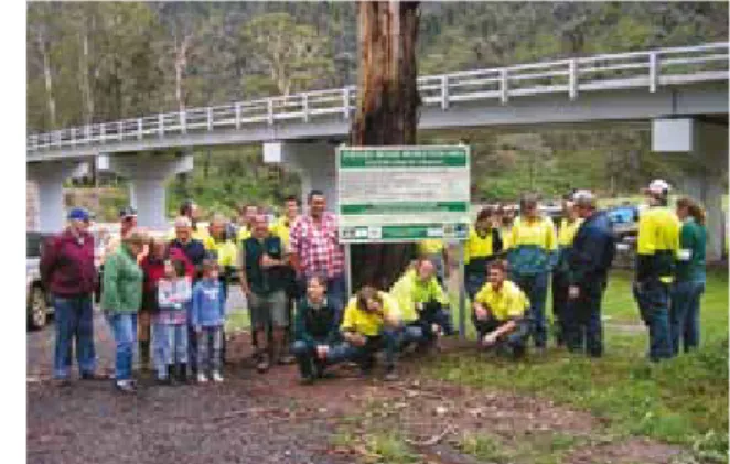
4.7 LiCOLA MULTi-PURPOSE COMMUNiTY FACiLiTY
A new tourist and community facility was opened in Licola on 27 November, 2009 (see Figure 17). The Licola Multi-Purpose Community Facility includes undercover picnic and barbecue facilities, a community meeting room, a new CFA station, information panels and refurbished public toilets. The interpretive panels,provided by Parks Victoria present information on local flora and fauna, Indigenous practices
and history. This facility was jointly funded by the Victorian Government through the Flood/Storm Recovery Program, the Wellington Shire Council, and the CFA.
5. NATURAL VALUES: Outcomes and achievements
ALLOCATiON $1.1M
Objectives and Strategies
● Protect high value biodiversity (flora and fauna) assets from high to extreme risks
● Improve the understanding of the impact of the flood and storm event on biodiversity
● Minimise the risk associated with established and new emerging weeds
● Minimise the risk associated with predators and introduced grazers on high value fauna and flora
● Minimise pest plants and animals along the public/private land interface
Achievements
● Reduction of immediate negative impacts on high value ecosystems through fencing repairs, debris
removal, weed spraying and erosion control.
● An improved understanding of the impact of the flood and storm event on platypus populations
and Ecological Vegetation Classes.
● An extensive fox baiting program to minimise risk to fauna.
● The use of a biological control to mitigate the post-flood spread of blackberry.
● Support for the Good Neighbour Program, which involves a combined effort between the DSE and
landholders to control weeds at the private/public land boundary.
● Extensive weed spraying along riparian areas affected by the flood.
The Flood Recovery Plan detailed five objectives specifically targeting the impact of the flood on rare or threatened species and communities, and minimising the development and establishment of
5.1 PLATYPUS SURVEYS
Being a top-level predator, the presence of the iconic platypus in waterways is an excellent measure of river-health. Despite this, to date, no surveys have been carried out to investigate the effects of flooding on platypus populations (Serena & Williams, 2008). In response to this and to concerns that the platypus population in the Macalister catchment upstream of Lake Glenmaggie had been adversely affected by the flood with the possibility of local extinction due to the inundation (Glenmaggie Weir), DSE partnered with the Australian Platypus Conservancy (APC) and PV to conduct live-trapping surveys from the 12th of March to the 12th of May 2008 to assess platypus numbers. In addition, community members took part in a platypus sighting program. The surveys were carried out in State forest along four Gippsland stream or river systems that suffered the major impact of fire and flood events in 2007 (for an example the damage incurred along river banks, see Figure 18).
Platypus were trapped in each of the four survey areas (for example, see Figure 19), which were:
● Wentworth River/Pheasant Creek (Mitchell River Catchment)
● Valencia Creek (Avon River Catchment)
● Mount Skene Creek/Barkly River (Macalister River Catchment)
● Aberfeldy River/Donnelly Creek (Thomson River Catchment)
Approximately double the number of animals were found inhabiting the Wentworth River and Mount Skene Creek (1.2 adults per kilometre of waterway), compared to the Aberfeldy River and Valencia Creek (0.6-0.7 adults per kilometre of waterway). There was also a correlation between the areas displaying the most severe riverbank erosion and sediment deposition, and the areas with the lowest platypus numbers. It was concluded that the severe flooding in mid-2007 had an adverse effect on platypus numbers. The report, which is now available, concluded that major floods can cause platypus fatalities directly, as a result of stress and exhaustion and indirectly, through degradation of habitat and shelter (Serena & Williams, 2008). On a positive note, juvenile platypus were recorded in three of the four study areas, providing evidence that populations are re-recruiting.
5.2 ECOLOGiCAL VEGETATiON CLASS STUDiES
Ecological Vegetation Class (EVC) Studies were performed by the consultancy firm, Practical Ecology, to assess the impact of the flood events on various EVCs. The study areas were located on public land within the catchments of central and east Gippsland, including the Thompson, Avon, Perry, Mitchell and Tambo Rivers and one wetland adjacent to the Latrobe River. In total, EVC assessments were performed at twelve study sites.
The aims of the studies were to:
● Identify threatened Ecological Vegetation Classes which have been significantly affected by the
June 2007 floods.
● Present the results of an on-ground survey and assessment of the condition and recovery of
threatened EVCs at twelve sites.
● Document the occurrence of significant flora and or fauna species.
● Assess data and information from relevant literature and databases.
The results of the studies were presented in a report titled ‘Condition assessment of threatened EVCs following the June 2007 floods of Gippsland, Victoria,’ (30th of June, 2008, Practical Ecology). In summary, it was reported that of the 382 flora taxa recorded within the study areas, 286 were indigenous and 96 were introduced. Several species listed as Victorian Rare or Threatened Species
(VROTS) were identified, including Long-flower Beard-heath Leucopogon juniperinus, Yellow-wood
Acronychia oblongifolia and Eastern Bitter-bush Adriana tomentosa var. tomentosa. The post-flood
impacts varied from study site to study site, with some areas displaying extreme erosion and debris deposition, while other areas appeared to be un-impacted. As expected, threatened EVCs flanking waterways were most severely impacted with damage including debris deposition, vegetation removal, erosion, post flood cohorts, exotic species invasion and siltation. Threatened EVCs situated higher in the riparian zone profile were, as expected, less impacted by the flood event. Exotic species invasion was evident at all study sites, however, the degree to which the flood event was responsible for the extent of exotic species colonisation could not be determined. Native species were also re-generating at several of
5.3 SMARTER wEED CONTROL
Following the 2007 floods, riparian zones flanking the flood-affected rivers were inundated with weeds. These areas are notoriously difficult to access for effective weed-control. Previously, bulldozers were used to create tracks for ground crews, who then hand-sprayed the weeds. Innovative DSE staff developed a method to tackle the issues of access and weed control in parallel. An excavator was modified (see Figure 20) to mulch a pathway to the weed-infested area and subsequently spray the weeds. The excavator can treat up to ninety percent of the weed infested areas along rivers; whereas the previous method of using bulldozers and ground crews only treated forty to sixty percent. The new method is also more cost-effective, reportedly providing a cost-saving of thirty percent. Furthermore, the new method also provides safety benefits, with the plant operator remaining a good distance from the weed spraying chemicals at all times.
Fig. 20: Using an excavator as a weed spraying platform was an innovation that has allowed more effective and efficient blackberry control along riverbeds and streams.
5.4. DiSCOVERY OF A NEw AND EMERGiNG wEED – ThE MEXiCAN POPPY
Following the flood events of 2007, a new weed was identified in the Wonnangatta Valley. The
Mexican Poppy (Argemone Mexicana) (see Figure 21), is toxic to stock, but is not readily eaten. The
weed establishes best without competition, and inhabits bare, gravel pits (see Figure 22), which were abundant following the flood events. The DSE and the West and East Gippsland Landcare networks continue to work in partnership to prevent the spread of this weed to downstream environments. Anecdotal evidence suggests that the re-establishment of native vegetation post-flood has limited the colonisation of this noxious weed. The weed is currently controlled by hand removal; as herbicide spraying has proved ineffectual. As Mexican Poppy seeds can remain dormant for several years, the DSE and local Landcare groups will remain vigilant in monitoring riparian areas for this weed.
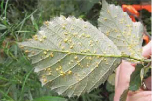
5.5 BLACkBERRY LEAF RUST FUNGUS
The major focus for the DSE’s weed management activities under the Flood/Storm Recovery Program was blackberry management. River frontages and campsites denuded of vegetation were targeted for weed management works post-flood. The denuding of vegetation acted to facilitate access to previously inaccessible areas with well-established weed populations. Excellent results were achieved in blackberry management via parallel spraying and biological control programs. The latter program involved the
release of the blackberry rust, Phragmidiumviolaceum (see Figure 23), at more than twenty sites across
Gippsland, within the Thomson, Aberfeldy, Macalister, Avon and Mitchell river catchments. Anecdotal evidence suggests that the rust release resulted in heavy defoliation of blackberry plants and a marked reduction in the production of daughter plants.
Fig. 23: The blackberry rust, Phragmidium violaceum
6. INDIGENOUS HERITAGE: Outcomes and achievements
ALLOCATiON $300 k
Objectives and Strategies
● Recognise traditional owners and their elders
● Foster relationships and knowledge exchange
● Prevent damage to indigenous sites and places during recovery work
● Protect Indigenous sites and places
● Develop a more complete picture of archaeological record of indigenous sites
● Assess the impact of flood on known post-settlement sites
● Protect priority post-settlement sites
Achievements:
● The involvement of the Victorian Alps Indigenous Reference Group (VAIRG) in the steering of the
flood and storm recovery program
● The performance of several cultural heritage inspections to ensure proposed recovery-works
conformed with the Aboriginal Heritage Act of 2006
● A post-flood Indigenous archaeological survey
6.1 RECONCiLiATiON wEEk BUS TOURS
As part of Gippsland Regional Reconciliation Week celebrations, several PV and DSE staff and members of local Indigenous groups participated in two bus tours (to Blue Pool and Dermody’s Campsite). Blue Pool, north of Briagolong, is reputed as a traditional women’s site. Dermody’s Campsite, in the Avon-Mt Hendrick Scenic Reserve, north of Boisdale, is a signficant cultural heritage site, with large artefact scatters. Both areas are very popular with locals and tourists as they are equipped with camping and barbeque facilities and display spectacular scenery. The Great Divide Fire in 2006/07 destroyed walking tracks, signage, seating and other infrastructure at both sites. These were rehabilitated shortly after the fire, however, the amenities at Blue Pool were destroyed again in the flood events, which also exposed artefact scatters (Figure 24).
The bus tours were organised by the Recovery Community Engagement Team to promote the Flood/ Storm Recovery Program and explain what was being done to respect cultural heritage values in damaged areas. There was also an oppurtunity for participants to learn about the Indigenous history of the affected regions. A smoking ceremony was held at one of the sites to cleanse the area and the people (see Figure 25). The tours presented an opportunity for staff working outside the recovery program to witness the devastating effects the fires and floods had on the natural environment in parts of Gippsland. All participants bore witness to the tremendous effort that has gone into the recovery of the affected areas and were given the chance to appreciate the Indigenous history of the region.
Fig. 24: Many indigenous artefacts were uncovered by the flood and fire events.
Fig. 25: A smoking ceremony was held to cleanse the site and the people.
6.2 ARChAEOLOGiCAL FLOOD SURVEY
After the fires and floods in 2006/07, there was concern that cultural heritage sites may have been damaged. Conversely, the fires and floods provided the opportunity to identify new sites by facilitating access to previously inaccessible areas and by uncovering artefact scatters. To assess the condition of known sites and to identify new sites, a tender was prepared for an Archaeological Flood Survey. Survey locations were developed in consultation with Gunai/Kurnai representatives and Aboriginal Affairs Victoria (see Figure 26). Following an unsuccessful tendering process (no bids were received), Ironbark Heritage and Environment were contracted to undertake the survey.
Field assessments were delayed by the extended tendering process and the seasonal closure of roads into the survey sites. The delayed start impinged on the quality of the data as understorey regrowth had occurred, obscuring sites of interest. The field assessments involved Gunai/Kurnai community representatives. Some areas still await survey and it is hoped that the survey process will be completed by January, 2010.
Some of the outcomes of the survey were:
● A number of cultural heritage sites were identified and recorded across the surveyed areas.
● Heavy sedimentation has covered some previously known sites.
● In one location erosion of the stream bank exposed artefacts in the bank cross section.
● Surface flow appeared to have washed artefact-bearing top soil down onto the bed of the
Wellington River.
● Severe erosion has removed streamside banks and flats that probably had artefacts present in the
Aberfeldy and Wellington catchments.
7. COMMUNITY AND TOURISM RECOVERY
ALLOCATiON $1M
Objectives and Strategies
● Promote the local tourist industry
● Support flood-affected communities to undertake local events
Achievements
● The involvement of the community in the Public Land Re-opening Strategy.
● The employment of Licensed Tourism Operators through the Licensed Tourist Operator Employment
Scheme.
● Media releases for the re-opening of roads, tracks, camping sites promptly released following the
completion of repair works to encourage the return of tourists to damaged areas.
● The publication of a news article in Track Watch (4WD Victoria).
● The production of a flood recovery media insert for distribution to the community through
Gippsland regional newsletters, tourist information centres and other strategic locations.
● The funding of 33 committees of management for various works on Crown Land.
● The re-opening of the Gippsland Plains and East Gippsland Rail Trails within 14 and six months,
7.1 COMMUNiTY iNFRASTRUCTURE ON CROwN LAND
Committees of Management (COMs) for Crown Land manage a significant area of land and associated community assets such as Community Halls, Recreation Reserves, Racecourses, Mechanics Institutes and Surf Life Saving clubs. In total, 33 COMs received funding for works which included structural repairs to buildings, electrical repairs and debris removal. Examples of the types of projects funded are described below. In previous disaster events, COMs have not received support directly through DSE; rather they were required to apply for Community Grants administered by the Department of Human Services. The new funding agreement arranged within the Flood/Storm Recovery Program allowed DSE to directly support these projects, thus streamlining the process.
The COM for the Old Gippstown ‘Gippsland Heritage Park’ in Moe received funding through the Flood/ Storm Recovery Program to repair damage to building exteriors and artefacts. Old Gippstown is a not for profit community-based program operating a heritage park on Crown Land. Over eighty percent of the buildings at the heritage park are original, dating back to the 1840s. The village was created by relocating buildings from around the Gippsland region to the site in Moe. The funding received from the Flood/Storm Recovery program was used to replace roofs on a number of the buildings; repaint walls; steam clean carpets; repair flashings and gutters, resurface the main access through the park and install drainage systems.
Funding was also allocated to the COMs for the East Gippsland and Gippsland Plains Rail Trails. The East Gippsland Rail Trail (EGRT) runs between Bairnsdale and Newmerella (near Orbost) over a total of 94 km. The Gippsland Plains Rail Trail (GPRT) extends 65 km from Stratford to Traralgon in Central Gippsland. The trails pass through varied landscapes of farmland, State forest and townships. Both Rail Trails, which are managed by COMs with assistance from DSE, suffered extensive damage in the 2007 floods. On the EGRT, two sections of the cutting near Lees Road collapsed as a result of a drain washout and the
subsequent extreme runoff (see Figure 27). Approximately 720cubic metresof old rail ballast was used
to reinstate the damaged embankments (see Figure 28). On the GPRT, several crossings were damaged as well as the Rainbow Creek Bridge. The rehabilitation of both rail trails received strong community support. The Gippsland Plains and East Gippsland Rail Trails were re-opened within fourteen and six months respectively of the June flood event.
7.2 COMMUNiTY ENGAGEMENT
The objectives for the community engagement program with respect to the Flood/Storm Recovery Program were to:
● Maintain and foster relationships with the local communities
● Promote the role of the community in the flood recovery process
● Engage stakeholders in recovery processes, achievements and activities
● Assist communities in the adaptation to the new landscape
A number of community engagement activities have been undertaken to inform the community about the extent of the flood damage, gain the community’s perspective on the prioritisation and implementation of recovery works, and to support the community in its recovery process. Some of community engagement activities that were organised are listed below:
● Community input invited for the development of the Access Re-opening Strategy
● The employment of Local Tourism Operators (LTOs) in recovery works
● Support for the Licola Recovery and Development Committee
● Support for volunteers from the Victorian Association of Four Wheel Drive Clubs for their
involvement in track clearing
● A talk on the recovery process was given to school groups in Cowwarr (September, 2007)
● The facilitation of tree planting days in Cowwarr (September, 2007) and Heyfield (November, 2007)
7.3 TOURiSM
The tourism industry in Gippsland was seriously impacted by the 2006/07 Great Divide Fires and the subsequent floods. The DSE and PV supported the tourism industry in Gippsland by prioritising recovery works in areas that experience high visitor numbers including the 90 mile beach coastline, recreation sites at the Gippsland Lakes, and prominent parks. For example, access to 90 mile beach was restored and jetties and piers servicing the Gippsland Lakes rehabilitated prior to the peak summer period. The tourism industry was also supported by the restoration of visitor access to National Parks and State Forest. Where possible, the re-opening of roads was fast-tracked to facilitate access for residents and tourists. For example, the severely damaged Tamboritha road, which provides access to the Alpine National Park from Licola, was inspected by a contracted safety expert to determine what public safety actions were needed to allow a partial opening of the road whilst reconstruction continued. This process allowed public access to this road within three months of the flood event, rather than having the road remain closed for fifteen months until the works were completed. The DSE and PV produced a single public document (Access Re-opening Strategy – available on the PV website) which detailed all of the roads closed due to fire/flood damage and their likely date of re-opening. Works were scheduled to facilitate the re-opening of groups of roads to coincide with peak visitor periods such as long weekend or Easter.
Some commercial businesses are heavily or wholly dependant on public land for their business continuity; in particular Licensed Tour Operators. To
support their recovery and that of the local economy and tourism industry, DSE and PV utilised these professionals where possible, capitalising on their skills and knowledge to assist works on public land.
8. REPORTING AND REVIEW
The DSE and PV reported on the implementation of the actions of the Gippsland Flood/Storm Recovery Program, undertaken to recover damage incurred on public land in the flood events in 2007. Four progress reports were prepared for the quarters to September, 2007; December, 2007; March, 2008 and June, 2008. These reports were prepared for the Project Control Board and the Executive Directors of DSE and PV. The progress reports were made available to the public via FireWeb. The reports were used to identify ongoing issues or emerging threats (e.g. weed invasion) that may need to be addressed by follow-up programs. The reports were also used to gauge the progress of the various recovery programs and their expenditure. This report forms the final report for the Gippsland Flood/Storm Recovery Program.
8.1 LEARNiNGS
Two facilitated workshops were held with staff involved in the recovery program to capture their views on the successes and failures of the Flood/Storm Recovery Program. The workshops were held in winter, 2008, in order to capture the views of recovery staff before they were re-deployed to other duties. Most views of staff at the workshops were positive. They were particularly impressed with:
● The coordination of DSE and PV recovery efforts
● Access Re-opening strategy, led by Parks Victoria
● The receipt of the $10M advance for recovery works
● The coordination and engagement of external contractors
● The ability to capitalise on the fire recovery process already in place
● The delegation of authority from a central point
REFERENCES
DSE and PV (2008) Gippsland Flood/Storm Recovery Plan. Victorian Government Department of Sustainability and Environment and Parks Victoria.
Practical Ecology (2008) Condition assessment of threatened EVCs following the June 2007 floods of Gippsland, Victoria. A report prepared for Parks Victoria.
Serena, M. and G.A. Williams (2008) The status of Platypus in flood and fire affected catchments in Gippsland, 2008. A report to Department of Sustainability and Environment and Parks Victoria. Australian Platypus Conservancy.
APPENDIX 1: FINANCE
Pr o je ct N u m b er im p le m en ta ti o n A llo ca ti o n 07 /0 8 Ex p en d it u re 37 45 9 Ro ad & w al ki ng t ra ck r is k as se ss m en t & r eo pe ni ng (D SE ) $ 2, 20 0, 00 0 (P V ) $ 2, 50 0, 00 0 (D SE ) $ 2, 88 4, 58 6 (P V ) $ 2, 50 0, 00 0 37 46 0 Br id ge r is k as se ss m en t & r ep la ce m en t 37 45 7 Ra il tr ai ls $6 00 ,0 00 $7 12 ,9 23 37 45 0 C oa st s an d po rt s $1 ,4 00 ,0 00 $1 ,1 63 ,1 82 37 45 8 Bu ilt a ss et s & in fr as tr uc tu re (D SE ) $ 40 0, 00 0 (P V ) $ 20 0, 00 0 (D SE ) $ 23 9, 51 6 (P V ) $ 20 0, 00 0 $7 ,3 00 ,0 00 $7 ,7 00 ,2 07 37 45 2 W ee ds , p re da to rs & f er al a ni m al s (D SE ) $ 30 0, 00 0 (P V ) $ 10 0, 00 0 (D SE ) $ 42 4, 14 7 (P V ) $ 10 0, 00 0 37 75 3 Re m ov e hi gh p rio rit y fa un a at r is k of lo ca l e xt in ct io n (D SE ) $ 10 0, 00 0 (P V ) $ 10 0, 00 0 (D SE ) $ 60 ,0 00 (P V ) $ 10 0, 00 0 Im pa ct s of fi re s on k ey p op ul at io ns 37 45 6 $5 00 ,0 00 $4 77 ,7 72 1, 10 0, 00 0 $1 ,1 61 ,9 19 iT A G E 3745 4 (P V ) $ 20 0, 00 0 (P V ) $ 20 0, 00 0 37 45 5 (D SE ) $ 10 0, 00 0 (D SE ) $ 30 ,0 00 $3 00 ,0 00 $2 30 ,0 00iv es Pr o je ct N u m b er im p le m en ta ti o n A llo ca ti o n 07 /0 8 Ex p en d it u re Ti O N A N D C O M M U N iT Y E N G A G EM EN T 37 46 2 $2 00 ,0 00 $9 8, 47 9 $2 00 ,0 00 $9 8, 47 9 Y A N D T O U RI SM R EC O V ER Y m un ity in fr as tr uc tu re o n 37 45 3 $1 ,0 00 ,0 00 $9 46 ,6 73 $1 ,0 00 ,0 00 $9 46 ,6 73 N SE C O ST S 88 00 1 (D SE ) $ 10 0, 00 0 (D SE ) $ 10 2, 31 2 $1 00 ,0 00 $1 02 ,3 12 $1 0, 00 0, 00 0 $1 0, 23 9, 59 0* en di tu re ($ 23 9, 59 0) w as f un de d th ro ug h in su re d w or ks .
APPENDIX 2: OPERATIONS
o n al an ce t o r ep o rt O n t ra ck B eh in d s ch ed u le Si g n ifi ca n t is su es t h at n ee d r es o lv in g je ct B u d g et fo r 07 /0 8 St at u s (s ee k ey ) A ch ie ve m en ts C o m m en t & is su es v eh ic le r oa ds , ki ng t ra ck s an d vi si to r s of f al le n de br is , c le ar ns , g ra de r oa ds , a ss es s m iti ga te d an ge ro us s an d ot he r ris ks in rd an ce w ith t he rit y of t he r e-op en in g te gy b y 30 J un e 20 08 . $4 ,3 00 ,0 00 $8 0, 00 0 $3 ,5 00 ,0 00 C o m p le te • D eb ris r em ov ed f ro m r oa d an d tr ac k ne tw or k • Tr ee h az ar d as se ss m en ts u nd er ta ke n • A ll ro ad s w ith ou t m aj or in su ra nc e w or ks r e-op en ed • M aj or ity o f ro ad /t ra ck n et w or k re -e st ab lis he d an d pr og re ss d oc um en te d in r e-op en in g st ra te gy • Th is is c om m un ic at ed in t he r e-op en in g st ra te gy f or G ip ps la nd ir Ro ad s B eh in d sc h ed u le • Pa rk s V ic to ria r oa d an d tr ac k sy st em c om pl et e • M os t D SE -m an ag ed r oa ds r e-op en ed , s om e ne ed ad di tio na l r ep ai r (s ee T ab le 1 ). U nfi ni sh ed r oa ds a re aw ai tin g th e pr oc es si ng o f in su ra nc e cl ai m s • So m e re pa ir/ re pl ac em en ts in co m pl et e, w ai tin g on t he pr oc es si ng o f in su ra nc e cl ai m s ov e de br is a nd r ep ai r ur fa ce . R ep ai r or ac e br id ge s an d ot he r ct ur es t o en su re s af et y co m pl ia nc e w ith ne er in g st an da rd s. $6 00 ,0 00 C o m p le te • Ea st G ip ps la nd R ai l T ra il re -o pe ne d w ith in s ix m on th s of t he m aj or fl oo d ev en t • G ip ps la nd P la in s Ra il Tr ai l r e-op en ed w ith in f ou rt ee n m on th s of t he m aj or fl oo d ev en t • Po te nt ia l f ut ur e co st o f $1 M t o co ns tr uc t fo ot / cy cl e br id ge s ov er m aj or r iv er s ge w ith s ta ke ho ld er s en tif y pr io rit y w or ks , te P ar kW eb t o in fo rm ic o f ro ad r e-op en in gs . C o m p le te • Fl oo d an d fir e re -o pe ni ng s tr at eg ie s am al ga m at ed an d up da te d on P ar kW eb • Pu bl ic s es si on t o fa ci lit at e pu bl ic in pu t in to t he r e-op en in g st ra te gy h el d in B ai rn sd al e an d Tr ar al go n • C on tin ue t o up da te s ta tu s of r oa ds on P ar kW ebra te g y Pr o je ct B u d g et fo r 07 /0 8 St at u s (s ee k ey ) A ch ie ve m en ts C o m m en t & is su es ti n u ed st or e be ac h ac ce ss on g 90 M ile B ea ch , cl ud in g as se ss m en t of or el in e ha za rd s by 3 0 ne 2 00 8 A ss es s an d re pa ir of se aw al ls a nd b re ak w at er s. A ss es s sh or el in e at f ou r m aj or e ro si on s ite s an d m in im is e ha za rd s to sw im m er s an d bo at u se rs . $1 ,0 00 ,0 00 C o m p le te • A bo rig in al s ite a t Ro un dh ea d pr ot ec te d • M ar ly P oi nt s ea w al l r ep la ce d • A cc es s to N in et y M ile B ea ch c oa st lin e re st or ed (M cL ou gh lin s Be ac h, T he H on ey su ck le s an d Pa ra di se Be ac h (P V )) • Er os io n pr ot ec tio n an d tr ac k re pa ir pe rf or m ed a lo ng th e Lo ch S po rt F or es ho re • M as on s Ba y bo ar dw al k an d re cr ea tio n fa ci lit ie s re st or ed (P V ). st or e fu nc tio ni ng o f at in g ca pa bi lit y w ith in ip ps la nd L ak es b y 30 ne 2 00 8 Su pp or t G ip ps la nd P or ts to r e-es ta bl is h th ei r fu ll ca pa ci ty b y 30 S ep te m be r 20 07 . $2 00 ,0 00 C o m p le te • Fl oo d da m ag e th e Pa yn es vi lle B oa t Ya rd a nd W or k C en tr e re pa ire d • Je tt ie s, s ea w al ls , w ha rf s an d na vi ga tio n ai de s in sp ec te d fo r da m ag e • Fl oa tin g de br is r em ov ed • M itc he ll Ri ve r Si lt Je tt ie s re pa ire d an d st ab ili se d • G ip ps la nd P or ts (G P) in su ra nc e cl ai m c om pl et e • G P St af f su pp or te d Ea st G ip ps la nd Po rt s w ith in sp ec tio ns a nd m on ito rin g of b oa ts o n m oo rin gs . A ll w or ks c om pl et e. pp or t flo od a ff ec te d m m un ity r es er ve s fr as tr uc tu re Re m ov e flo od d eb ris an d fa ci lit at e re pa ir/ re pl ac em en t of d am ag ed in fr as tr uc tu re o n C ro w n La nd m an ag ed b y lo ca l C om m itt ee s of M an ag em en t (C O M s) . $1 ,5 00 ,0 00 C o m p le te d • Fo rm al a rr an ge m en ts m ad e w ith C O M s fo r th e re co ve ry p ro ce ss • 33 C om m un ity P ro je ct s su pp or te d fin an ci al ly a nd ad m in is tr at iv el y e. g. W ah al la L on g Tu nn el M in e ($ 24 5, 10 1) , W ah al la T ou ris m R ai lw ay B rid ge s ($ 75 ,0 00 ), G ip ps la nd H er ita ge P ar k ($ 11 2, 37 0) , La ke s En tr an ce R es cu e Sq ua d ($ 60 ,0 00 ) • Po si tiv e fe ed ba ck r ec ei ve d fr om C O M s re ga rd in g D SE r ec ov er y su pp or t • 35 a ge nc ie s di re ct ly in vo lv ed in r ec ov er y pr oj ec t, 5 n ew m an ag em en t ar ra ng em en ts st or e th e w al ki ng t ra ck tw or k by 3 0 Ju ne 2 00 8 Re st or e se ve re ly d am ag ed w al ki ng t ra ck s an d as so ci at ed in fr as tr uc tu re in cl ud in g th e Sa le C om m on a nd M itc he ll Ri ve r w al ki ng t ra ck s. $8 00 ,0 00 $2 5, 00 0 C o m p le te • Bl ue P oo ls a nd A vo n (C ha nn el s – H ug ge ts ) w al ki ng tr ac ks r e op en ed • Sa le C om m on B oa rd w al k re -o pe ne d • Bo ar dw al k at E w in gs M or as s at P et tm an s Be ac h co m pl et e ss et s re pl ac ed fi t fo r rp os e, c on si st en t w ith st ai na bl e pr in ci pl es d fu lly c om pl ia nt w ith le va nt s ta nd ar ds b y 30 ne 2 00 8 C om pi le li st o f da m ag ed as se ts o n pu bl ic la nd . Tr ea t si te s to p ro te ct pu bl ic s af et y an d re m ov e da m ag ed o r de st ro ye d st ru ct ur es . U nd er ta ke p la nn in g an d de si gn t o re pl ac e as se ts in ac co rd an ce w ith p rio rit ie s. C om pl et e re pa ir an d re pl ac em en t pr og ra m . $4 00 ,0 00 C o m p le te • Li st o f da m ag ed a ss et s in E ric a/ H ey fie ld c om pl et ed an d lo dg ed w ith in su re rs . • Re pa irs t o al l C an n Ri ve r re cr ea tio n si te s co m pl et ed . • Bl ue P oo l w or ks c om pl et ed a he ad o f sc he du le . • C am pg ro un d gr av el lin g in E ric a di st ric t co m pl et ed . • G ip ps la nd L ak es D is co ve ry T ra il re pa irs a nd r eg ra de co m pl et ed f or s ch oo l h ol id ay u se . • M ou nt T ay lo r Bo ys C am p re pa irs c om pl et ed w ith re ve ge ta tio n ar ea s fe nc ed o ff . • D ep tf or d ca m pg ro un d ac ce ss r ep ai re d. • Re pl ac em en t of f ac ili tie s w as in a cc or da nc e w ith A us tr al ia n St an da rd s an d D SE F ac ili tie s D es ig n C om m itt ee .